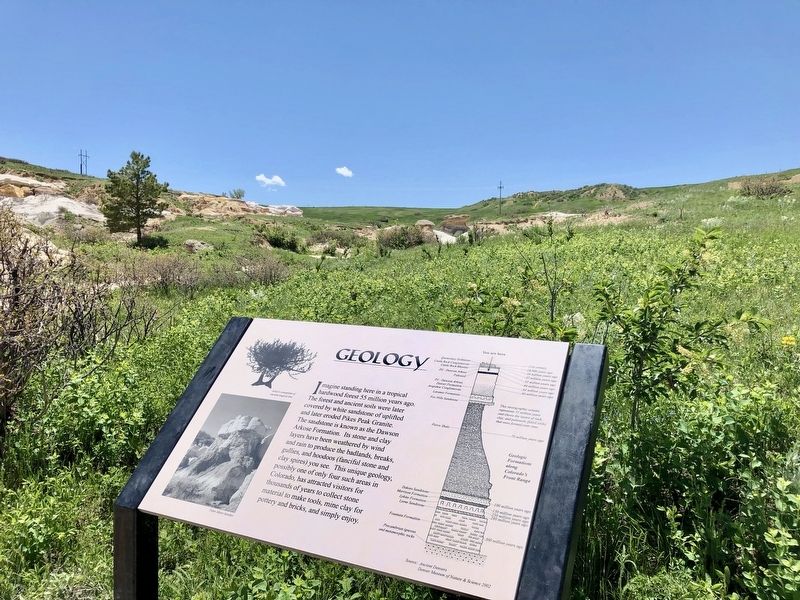
Imagine standing here in a tropical hardwood forest 55 million years ago. The forest and ancient soils were later covered by white sandstone of uplifted and later eroded Pikes Peak Granite. The sandstone is known as the Dawson Arkose Formation. Its . . . — — Map (db m135458) HM
The Rocky Mountains are the longest chain of mountains in the world. They divide the United States watershed between the Atlantic and Pacific Oceans. Colorado has 53 peaks over 14,000 feet. One inch on the Horizon equals about 38 miles. — — Map (db m4838)
In recognition of the notable career of
Zebulon Montgomery Pike,
· Soldier -- Explorer ·
The people of Colorado have placed this tablet on the summit of the great mountain first seen by Pike, November 15, 1806.
General Pike was born at . . . — — Map (db m4865) HM
The Town of Castle Rock is named after Rock Park, a historic natural landmark and perhaps the most visible open space property in Castle Rock. Since 1935, this important landmark has been famous for the annual starlighting ceremony. Rock Park became . . . — — Map (db m232534) HM
World War II (side one)
This monument is dedicated to the Timberwolves and all attached units that served with the 104th Infantry Division to eliminate the Nazi Powers in Europe in World War II. It shall serve as a memorial to our 1,473 killed . . . — — Map (db m251345) HM WM
In honor of those who
served the Aerospace Defense
Command of the United States
Air Force and dedicated to
those who have made
their final flight — — Map (db m251401) WM
All gave some
Some gave all
For combat wounded
Military Order
of the Purple Heart
Chapter 423
Dedicated Feb. 22, 1998
Commander Ernie R. Kelly
Auxiliary President
Ada L. Crowhurst
Guest Speaker
Congressional Medal of . . . — — Map (db m251294) WM
The U.S. Congress authorized the establishment of six, segregated Negro regiments on July 28, 1866. They recognized the military merits of African Americans by creating two cavalry and four infantry regiments.
In 1869, Congress enacted a . . . — — Map (db m251714) HM WM
This memorial is dedicated to those special Air Force aviators, support staff.
Army Special Forces and Marine observers
who lost their lives during the war in
Southeast Asia from 1961-1975 while flying or supporting the forward air controller . . . — — Map (db m251800) WM
In honor of those from El Paso County
that went above and beyond the call of duty.
Jesse N Funk World War I
Oct 31, 1918
US Army
Floyd K Lindstrom World War II
Nov 11, 1943
US Army
Gerald O Young Vietnam War
Nov 9, 1967 . . . — — Map (db m251286) WM
This monument is erected in grateful memory of those Canadians who died while serving with the United States forces and those Americans who died while serving with the Canadian forces. Their sacrifice strengthens and exemplifies forever the . . . — — Map (db m251321) WM
This land you are standing on was already rich in history when General
William Jackson Palmer founded the City of Colorado Springs in 1871.
This land was home to American Indian people for thousands of years.
Cheyenne Creek and its majestic . . . — — Map (db m208668) HM
September 3, 1868,
occurred on this mesa the
last massacre, in the Pike's
Peak Region, of whites by
Indians. The raiders were
Arapahoes. Near this spot
they killed and scalped
Charles Everhart age 17,
and a short distance west
of Mount . . . — — Map (db m281133) HM
(top side)
Radio Call Sign of Operation "Commando Sabre"
The Fast Forward Air Controllers (FACs)
Whose mission was to interdict the flow of supplies snd hostile forces on the Ho Chi Minh Trail in North Vietnam and Laos during 1967-1970 . . . — — Map (db m251811) WM
Anthony Bott, one of the founders of
Colorado City, quarried Dakota Sandstone
from the east face of the hogback (highest
ridge) in the 1870s and 1880s. These were
simple but significant operations for
supplying community needs. Vertical . . . — — Map (db m283032) HM
Almighty God, who art the author of liberty and the champion of the oppressed, hear our prayer. We, the soldiers of special forces, acknowledge our
dependence upon Thee in the preservation of human freedom. Go with us as we seek to defend the . . . — — Map (db m251322) WM
This monument is dedicated to honor
all who have served in the United States
Submarine Service: Especially those on
eternal patrol who gave their lives
protecting American freedoms. — — Map (db m251410) WM
(top side)
The Tactical Air Control Party
Airmen who fearlessly go into combat
with their Army brothers to provide the vital link between air and ground
Carrying the Forward Air Controller torch
From past to present and future battles . . . — — Map (db m251812) WM
This Plaque is dedicated to the fond memory of the men and families
who operated and maintained the Roswell Yards and kept the Chicago,
Rock Island & Pacific Railroad moving.
The Roswell Yards included a depot, 16 stall roundhouse, water . . . — — Map (db m304545) HM
Directly in front of you is the Academy which is dedicated to producing highly qualified and motivated officers for your U.S. Air Force. Its four year program combines Military and academic instruction and athletic competition. The airfield in the . . . — — Map (db m4884) HM
Dedicated To the 619 Coloradoans who gave their lives in service to their country
Take The Time To Remember... To Reflect... To Heal...
Memorial donated by Wilhelm Monuments — — Map (db m251393) WM
To honor those who fought
in the Korean War
25 June 1950-27 July 1953
United States casualties
33,651 dead
103,284 wounded
8,177 missing
7,140 POW — — Map (db m251323) WM
This memorial grove
and
sitting shelter
is dedicated in fond memory
of the passengers and air crew
of United Airlines #585
which crashed on this site
March 3, 1991.
Bonnie Bachman ·
Dan Birkholz ·
Andy Bodnar ·
Mildred Ann Brown . . . — — Map (db m214957) HM
Welcome to Colorado Springs
History of Colorado Springs
Founded as a resort town in 1871 by Civil War hero General William Jackson Palmer, the region has drawn visitors world-wide since its beginning. People traveled near and far to . . . — — Map (db m107277) HM
Dedicated to the War Dogs and their historic legacy of selfless service and heroic sacrifice saving American lives wherever deployed with their courageous handlers.
Lest we forget those valiant War Dogs that never came home and whose remains . . . — — Map (db m251717) WM
The land that makes up Red Rock Canyon Open Space was purchased
by the City of Colorado Springs in 2003. The five valleys and canyons of
the property are undeveloped open space, with hiking trails and climbing routes.
Today, the sandstone . . . — — Map (db m282544) HM
Pikes Peak
You are at 13,380 feet, 4,078 meters
Feeling Spacey? In the United States you can not get much closer to outer space than this! Are you dizzy and short of breath? No wonder, you are 2.5 miles (4 kilometers) above sea level! There is 40% . . . — — Map (db m45815) HM
The Ute Indians say they have always lived in the hills of Colorado. They referred to the Rocky Mountain’s easternmost peak as Sun Mountain because it vibrantly catches the early morning rays.
In the late 1700s, Spaniards referred to the peak as El . . . — — Map (db m45922) HM
Soon after President Abraham Lincoln signed the Homestead Act in 1862, homesteaders moved west across the prairies and spread into the hills of Pikes Peak. In the 1870s, the Crowe family claimed 160 acres in this valley that later came to be known . . . — — Map (db m45936) HM
Commemorating the 100th anniversary
of the inspiration of
"America the Beautiful"
by
Katharine Lee Bates
1859 - 1929
Following her visit to this Summit on July 22, 1893 . . . — — Map (db m45817) HM
Without fires, forests grow dense with trees that compete for nutrients, sunlight and space. Competition and stress leave forests susceptible to disease, insects and fire. Many plants on the forest floor die competing for nutrients adding to the . . . — — Map (db m45935) HM
As you drive up Pikes Peak, you’ll feel it get colder. You’ll also notice that the plants change. See if you can pick out four different life zones on the way to and from the summit.
A life zone is a plant and animal community that exists at . . . — — Map (db m45929) HM
Has been designated a Registered National Historic Landmark under the provisions of the Historic Sites Act of August 21, 1935 this site possesses exceptional value in commemorating and illustrating the history of the United States. US Department of . . . — — Map (db m45816) HM
Alpine and subalpine tundra is the low-growing vegetation found in the “land above the trees.” At this high elevation, the climate is harsh with searing winds, intense sunlight and frigid temperatures that limit the growing season. In . . . — — Map (db m45927) HM
The foothills of Colorado’s eastern slope form the dramatic meeting place of the Great Plains and the Rocky Mountains. In this transition area between the prairie and the mountains, grasslands intermix with scrublands of mountain mahogany and scrub . . . — — Map (db m45925)
When artists and photographers portray Colorado’s mountainous beauty, they usually capture the classic views of evergreen forests, stands of quaking aspens, and meadows of brilliant wildflowers. The montane area above 8,000 feet contains just such . . . — — Map (db m45926) HM
Watch and listen to see how many different birds you can discover on Pikes Peak. From the foothills to the summit, there are about 225 species. This variety is due to the number of habitats on the mountain. Can you match the birds to the habitat? . . . — — Map (db m45920) HM
The granite that make up Pikes Peak was once molten (or liquid) rock. It slowly cooled and hardened miles beneath the earth’s surface, giving the crystals time to grow. Over the last 500 million years several tectonic plates (the earth’s outer . . . — — Map (db m45921) HM
Passage from prairie to high plains
If you had been standing on this spot for the last 10,000 years, you would have seen the history of Colorado progress below you. This ancient route through the Rocky Mountains is named for Colorado’s Ute . . . — — Map (db m45761) HM
Take Your Time and Enjoy Your Trip: Allow at least two hours to make the 38-mile round-trip to the summit and back. Uphill traffic has the right-of-way at all times. Watch for maintenance equipment.
Driving Up: If your engine begins . . . — — Map (db m45932)
Did you know that Colorado Springs is almost a desert? Deserts receive less than ten inches of rain per year. The average precipitation in Colorado Springs is only about 15 inches per year. That’s pretty dry compared to Boston’s annual 44 . . . — — Map (db m45919) HM
The Nuúchi (Ute) People are the first inhabitants of this region, and are comprised of seven bands that historically lived here and in nearby areas of the Southwest: the Mouache and Caputa in the south; Weenuchiu to the . . . — — Map (db m267485) HM
The first documented use of skis in Colorado occurred in a snowbound mining camp during the winter of 1859-1860 near present-day Breckenridge. Ten men left in camp made skis and traveled down-valley where they built a cabin and claimed a town . . . — — Map (db m251018) HM
Carnegie Library, built 1905, has been placed on the National Register of Historic Places by the United States Department of the Interior — — Map (db m254744) HM
Cloyd Barnes, sculptor 1992 Bronze In the history of Colorado Springs and Colorado College, few individuals have been as generous or prolific in their public service as Charles L. Tutt Jr. As president of The Broadmoor, president of El Pomar . . . — — Map (db m257242) HM
On this site, on July 31, 1874, a stake was driven
into the ground marking the founding of the
City of Colorado Springs. At the time it was a
treeless prairie. Although the city's founder,
General William Jackson Palmer was away on
business, . . . — — Map (db m251169) HM
Completed in 1880, Cutler Hall
is Colorado College's first building.
On July 4, 1877, Colorado College
and the people of Colorado Springs
gathered to celebrate the beginning
of construction on the undeveloped
and isolated plot of prairie . . . — — Map (db m251731) HM
Born in Papetown, a northern Colorado Springs community, Nick worked in the family orchard and caddied at Patty Jewett and the Broadmoor. His first full-time job was at Blattman Nursery.
At age 22 he began a baseball career in the New York . . . — — Map (db m251022) HM
Hank the Cowboy has promoted the Pikes Peak or Bust rodeo since 1939. He was created and named by Stanley Reed, a staff artist with the Gazette/Telegraph, at the request of Spencer Penrose, founder of the
rodeo. He stands in this location to . . . — — Map (db m251011) HM
Author of "America the Beautiful"
Katherine Lee Bates (1859-1929) wrote the original version of this beloved anthem in 1895 during a stay in Colorado Springs. A brief trip to the 14,110 foot summit of Pike's Peak provided the inspiration for her . . . — — Map (db m250314) HM
On this spot stood the building
in which the first newspaper of
Colorado Springs was published. The
first religious services held. The first
educational work carried on. And it was the home of the first armory. — — Map (db m251034) HM
The completion of Palmer Hall in 1904 marked the crowning achievement of President William F. Slocum's 1888-1917 construction-filled tenure and provided the campus with one of its best-loved landmarks. Boston architectural firm
Andrews, Jacques, . . . — — Map (db m251728) HM
A native Philadelphian, Spencer Penrose
arrived in Colorado Springs in 1892 and became one of Colorado's most prominent
business, civic and philanthropic leaders.
He developed Utah's richest copper mine
and is best known for building the . . . — — Map (db m251008) HM
St. Mary's Cathedral
Built 1898
has been placed on the
National Register
of Historic Places
by the United States
Department of the Interior — — Map (db m286785) HM
The First Stake of the Fountain Colony was driven here
July 31 1871
Rededicated
NSDAR
Zebulon Pike Chapter
Kinnikinnik Chapter
August 1, 1983
D.A.R.
July 1, 1895 — — Map (db m202572) HM
Born into slavery on a plantation in central Kentucky, William Seymour and his wife, Elizabeth homesteaded in Kansas following the Civil War. In the late 1890's the Seymours migrated further west, herding their cattle from their Kansas ranch, and . . . — — Map (db m251015) HM
The people of Colorado have placed here this granite rock in recognition of the notable career of Zebulon Montgomery Pike · Soldier-Explorer · and in commemoration of the One Hundredth anniversary of his historic expedition
to the southwest . . . — — Map (db m201078) HM
The 1908 Van Briggle Pottery, situated on land given to the Pottery by General William J. Palmer, is a remarkable expression of the period and a showcase for the unique talents of the architect as well as the artists whose work it would house. . . . — — Map (db m201106) HM
Built in Cornwall, England, in the late 1830s, this walking beam engine was sold to the Vaucluse Gold Mine, located in Orange
County, VA, where it powered the mine's ore crushing stamp mill and other machines until just before the Civil War. . . . — — Map (db m255128) HM
Built in Marion, Ohio, in the 1920s, this steam shovel was used at the Sunrise Mine in Wyoming from 1929-1940, digging iron
ore in an open pit mine 750 feet deep and a quarter mile wide. The steam shovel was then disassembled and hauled outside . . . — — Map (db m255129) HM
This stone bridge located on the original road to the mesa reservoirs and Blair’s cabin was constructed by John Blair, landscape gardener, who had charge of the construction of grounds and stone structures in General Palmer’s Glen Eyre Estate and . . . — — Map (db m283085) HM
Cries of "gold!" lured countless
prospectors to Colorado's Rocky
Mountains in 1859. And while
miners went bust or hit pay dirt in
South Park, Leadville and later Cripple
Creek, Colorado City supplied the
means to continue the quest. At . . . — — Map (db m201136) HM
One of the earliest structures in
Colorado City, this false-fronted
log cabin was built in 1859 by
Dr. James Paul Garvin at 2608
West Colorado Avenue. In 1861,
the first Territorial Legislature met
in Colorado City, a candidate . . . — — Map (db m201139) HM
Built for the citizens of Colorado City. This library has been placed on the
National Register of Historic Places as a contributing building of the Old Colorado City Historic District. — — Map (db m304974) HM
This tablet is the
Property of the State of Colorado
———
Colorado City
Founded here in August, 1859
then in El Paso County Kansas.
So named because at the gateway
to mines thought to be on the
Colorado . . . — — Map (db m200383) HM
Colorado City was the first official capital of Colorado Territory. It sent a lobbyist to Washington, D.C. who succeeded in having the new territory which was established on February 26, 1861, named "Colorado". He also was able to have the . . . — — Map (db m251046) HM
Bear Creek is a small tributary of the Arkansas River west of Colorado Springs. It might be unremarkable - just another cold, clear stream among countless streams that carry water down Colorado's mountainsides- but it is important because of one of . . . — — Map (db m250603) HM
This tablet is the
Property of the State of Colorado
———
Log house from Colorado's first designated territorial capital, at Colorado City (now a part of Colorado Springs). This log log house was built in 1859. . . . — — Map (db m200386) HM
The first permanent settlement of the Pikes Peak Region.
The capital city of the Colorado Territory for four days in July 1862.
El Paso county seat for 10 years.
This location at the foot of Pikes Peak laid the foundation for the entire
Pikes . . . — — Map (db m201102) HM
The cabin came home in 1961. It
was placed in Bancroft Park, on
the site of the playground for the
old Bancroft School, in the 2400
block of West Colorado Avenue. The
school was named for prolific
nineteenth-century Western History
writer . . . — — Map (db m201144) HM
1891-1913 A Colorful Town
Overnight train layovers resulted in 21 bars, gambling dens and bordellos in Colorado City. Queen Laura Belle and Prairie Dog O'Byrne raced down Colorado
Ave, pulled by the elk Thunder and Buttons. . . . — — Map (db m251308) HM
Built in 1891, this building's first floor originally housed the dry goods firm of Woodland and Acheson. The second floor had furnished lodgings and the third floor had meeting rooms for several lodges. Henry Templeton was able to build this . . . — — Map (db m251037) HM
As the Temperance Movement swept across the country, the residents of Colorado City voted to "go dry" in 1913. The Women's Christian Temperance Union and others worked to ban liquor because they believed that their husbands, fathers, and . . . — — Map (db m304976) HM
This monument erected in memory of those unsung pioneers who helped build the Pikes Peak Region, the infants born to pioneer families of this area, and those later residents, both known and unknown, who came to this final resting place: Blocks 20, . . . — — Map (db m19080) HM
The Tesla Experimental Station was a laboratory built by Nikola Tesla in 1899 in an empty site on Knob Hill in Colorado Springs. The experimental lab stood north of this location on North Foote Avenue. The lab was operational from May 1899 to . . . — — Map (db m141526) HM
The First Summit House
You are looking at the remains of Pikes Peak's first summit house.
Built in 1882, this building was first used as a weather station. Hardy signalmen lived here year-round, tracking the summit's tumultuous . . . — — Map (db m282611) HM
The freedom memorial In honor of those men and women of the United States Armed Forces, who have fallen and served in The Global War on Terrorism.
They were fathers, mothers, sisters, brothers, sons, daughters.
Freedom from terror has a . . . — — Map (db m251799) WM
Erected in honor of those who gave their lives that this nation might be free. November 11, 1968
(Inscription etched around circumference of the center structure of the memorial) — — Map (db m251723) WM
The abundant seeds of piñon and juniper trees draw wildlife to this ecosystem like a magnet. Chipmunks, foxes, piñon mice and squirrels munch the blue or copper-colored juniper berries. The berries last through the winter. They provide food for . . . — — Map (db m45982) HM
In 1879, General William Jackson Palmer, the founder of Colorado Springs, convinced his friend, Charles Elliot Perkins to purchase land in Garden of the Gods. Perkins eventually bought a total of 480 spectacular acres surrounding the Gateway Rocks, . . . — — Map (db m135547) HM
617 entries matched your criteria. The first 100 are listed above. Next 100 ⊳