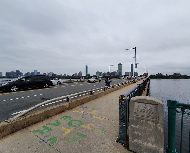
On Massachusetts Avenue at Memorial Drive, on the right when traveling south on Massachusetts Avenue.
In Commemoration of the 50th Anniversary of The Smoot.
In October 1958 the span of this bridge was measured using the body of Oliver Reed Smoot MIT '62 and found to be 364.4 smoots +/-1 ear. This provided a very useful metric for generations . . . — — Map (db m178280) HM
On Waverly Street, on the right when traveling north.
Constructed November 1775 by the Continental Army under General George Washington. This fort was used during the Siege of Boston and helped force its evacuation by the British. — — Map (db m18763) HM
On Prospect Street south of Hampshire Street, on the right when traveling south.
Clement Garnett Morgan, a graduate of Harvard College and Harvard Law School, was the first African American elected to the Board of Alderman in Cambridge. He was a founder of the Niagara Movement, a predecessor of the National Association for . . . — — Map (db m215272) HM
Historic Plaque On this spot stood Jake & Earl's Dixie BBQ
A favorite hangout of local patriots
Destroyed by a regiment of British troops in
the spring of 1775.
Officially not on the Freedom Trail, it was
still one of Paul Revere's . . . — — Map (db m70038) HM
Hear!
Dr. Martin Luther King
at
First Baptist Church
Central Square, Cambridge, Massachsuetts
Sunday, January 10, 1960 -- 7:30 P.M.
Special music by the Boston University Seminary Singers
Sponsored by the Cambridge . . . — — Map (db m215277) HM
On Magee Street east of Putnam Avenue, on the right when traveling east.
Franklin Hamilton Wright, a life-long resident of Riverside, was an early member of the City Council and one of the founders of the Cambridge Community Center. — — Map (db m215279) HM
On Essex Street north of Lamson Place, on the left when traveling north.
Charlotte Hawkins Brown was the founder of the Palmer Memorial Institute, a private preparatory school for African American children in Sedalia, North Carolina.
Charlotte, born in Henderson, N.C., was the daughter of Carole Hawkins and . . . — — Map (db m215274) HM
On Main Street at Osborne Street, on the right when traveling east on Main Street.
From this site on October 9, 1876 the first two-way long distance telephone conversation was carried on for three hours. From here in Cambridgeport Thomas G. Watson spoke over a telegraph wire to Alexander Graham Bell at the office of the Walworth . . . — — Map (db m49766) HM
On Norfolk Street at Washington Street, on the right when traveling south on Norfolk Street.
Lewis and John Milton Clarke, who were among the many contributors to the antislavery cause in Cambridge, were born in Madison County, Kentucky. They were the sons of an elderly white Revolutionary War veteran and a mulatto daughter of Samuel . . . — — Map (db m215275) HM
On Hampshire Street at Portland Street, on the right when traveling east on Hampshire Street.
A mural depicting the people, places and events from the history of Area 4 in Cambridge (historically known as Port and Cambridgeport) — — Map (db m215382) HM
On Hampshire Street at Norfolk Street, on the left when traveling west on Hampshire Street. Reported unreadable.
Founded in 1890, the Massachusetts Avenue Baptist Church is one of the oldest African-American congregations in Cambridge. The Church was erected in 1902 and 1910 in the Romanesque Revival style, has received a matching grant from Massachusetts . . . — — Map (db m215269) HM
On Hampshire Street at Tremont Street, on the right when traveling west on Hampshire Street.
Benedict M. Carvalho Sq.
F 2/c United States Navy
Born July 7, 1921
Killed in Action, February 1, 1943
Solomon Island
George Carvalho Sq.
Born April 25, 1926
T/5c United States Army
Died August 6, 1971
Cambridge . . . — — Map (db m215270) WM
On George P. Hassett Drive south of Salem Street (Massachusetts Route 60), on the right when traveling east.
[Left tablet]
Settlers were reported “upon Mysticke” in 1629. A larger group in 1630 settled near the square and named the place “Meadford”. The first recorded town meeting was held in 1674. In 1676 the first selectmen were elected and in . . . — — Map (db m198140) HM
On South Street at Curtis Street, on the right when traveling east on South Street.
In 1844 Lydia Maria Child (1802 – 1880) wrote of her childhood visits to her grandfather’s house at 114 South Street in the poem “Over the River and Through the Woods” from her home at the corner of Ashland and Salem Streets.
The rear . . . — — Map (db m294475) HM
On High Street (Massachusetts Route 60), on the right when traveling west.
On this site stood the Simpson Tavern, where in 1850 James Pierpont (1822–1893) wrote the song “Jingle Bells” in the presence of Mrs. Otis
Waterman, who later verified that the song was written here. Pierpont had the song . . . — — Map (db m50861) HM
Near Packard Avenue south of North Hill Raod when traveling south.
A Tufts Worthy and Benefactor. Founder of the Fletcher School of Law and Diplomacy. Donor of the Fletcher Professorships and many buildings. 1852-1926
"His outlook on life and life's activities was from a lofty standpoint. He detested small . . . — — Map (db m250244) HM
On High Street (Massachusetts Route 60), on the right when traveling west.
On the night of April 18-19, 1775, on his famous ride to Lexington, Paul Revere tethered his horse here and awakened Captain Hall of the Medford Minute Men to tell him that "The Regulars are out." — — Map (db m82651) HM
On Salem Street at George P Hassett Drive, on the right when traveling east on Salem Street.
Celebrating David McGillivray's 3,452-mile run in 1978 from Medford, Oregon to Medford, Mass. to benefit the Jimmy Fund.
"Those who say it cannot be done should not interrupt those who are doing it." - Dave McGillivray
Dedicated by Mayor . . . — — Map (db m244427) HM
On Salem Street (Massachusetts Route 60) at Spring Street on Salem Street.
At this location, local Medford brothers Bill and Tony Hanley established a pioneering sound company.
Innovations in speaker, amplification, microphone, and sound system design were born
here Powerful, high-quality sound reinforcement systems . . . — — Map (db m222226) HM
Near River Street at Salem Street, on the left when traveling south.
To the memory of revolutionary soldiers from Massachusetts and New Hampshire who lie in this burying ground in unmarked graves. Dedicated April 19, 1930 In Medford's Tercentenary year. — — Map (db m245270) HM WM
On Woodland Road at Molyneaux Circle at Molyneaux Circle on Woodland Road at Molyneaux Circle.
This circle is dedicated to the memory of Private Roy. V. Molyneaux 30th Division, U.S. Army
Who gallantly fought and gave his life for his country on the battlefield of France July 16th 1944
His deeds will be forever remembered by the . . . — — Map (db m73851) WM
This bell is an integral part of the history of Medford. It was cast in 1860 by Henry N. Hooper Company of Boston with a 44 inch diameter, 1,700 lbs. weight, in F Sharp.
The bell was constructed for the presidential campaign of the . . . — — Map (db m102591) HM
On Packard Avenue near North Hill Road, on the left when traveling south.
This is a replica of the majestic African elephant named Jumbo who enchanted millions while in the circus owned by Tufts University trustee P.T. Barnum. Jumbo's stuff remains were donated to Tufts by Barnum in 1989 and displayed in Barnum Hall . . . — — Map (db m250239) HM
Mansion built by Isaac Royall who came here from Antigua with his slaves in 1737. His son Isaac Royall, a loyalist, founded at Harvard the oldest law professorship in the United States. Headquarters of General John Stark during the Siege of Boston. — — Map (db m50420) HM
On Salem Street (Massachusetts Route 60) at Interstate 93, on the right when traveling west on Salem Street.
This plaque has been placed in memory of Elizabeth Short, the victim of one of the nation's most infamous and unsolved crimes.
"Betty" Short was born on July 29, 1924 and lived at 115 Salem Street, the site now occupied by the Interstate #93 . . . — — Map (db m222253) HM
The original portion of the Royall House appears to have been a farmhouse constructed in 1637 by Governor Winthrop as part of his "Ten Hills Farm." New Hampshire Lt. Governor John Usher enlarged the house and lived in it from 1692 until 1726. . . . — — Map (db m245594) HM
On Riverside Ave at Rockwell Ave, on the right when traveling west on Riverside Ave.
Known for many years as the Cradock House because it was thought to have been built in 1634 for Matthew Cradock, the construction of the house is now attributed to Peter Tufts. Although the exact date of its origin is obscure, it is known to . . . — — Map (db m55620) HM
On Grove Street at Ravine Road, on the right when traveling north on Grove Street.
The Slave Wall was built in 1765 by Pomp, a slave owned by Thomas Brooks, as a decorative entrance to his house. This site was part of the estate of the Brooks family, which was first occupied in 1679 and once included some 400 acres of land. The . . . — — Map (db m277322) HM
Near Salem Street at River Street, on the left when traveling west.
In Commemoration of
Captain Isaac Hall
1739 - 1789
Commander Medford Minute Men
Lexington - Concord alarm
April 19, 1775
A businessman and resident of Medford.
Presented on January 24, 1977
Medford Company of Minutemen . . . — — Map (db m245266) HM WM
On River Street south of Salem St, on the left when traveling south.
This property, which is listed in the State and National Register of Historic Places, has received a matching grant from the Massachusetts Preservation Projects Fund through the Massachusetts Historical Commission, Secretary of the Commonwealth . . . — — Map (db m245265) HM
On College Avenue at Professors Row, on the right when traveling south on College Avenue.
Dedicated to by the class of 1910 at their 25th reunion June 15, 1935 to the memory of absent members who have answered their last roll call. ( 17 names are listed ) — — Map (db m250243) HM
On Packard Avenue south of North Hill Road, on the left when traveling south.
This garden, which provides a home for Tufts' new Jumbo, was made possible through the generosity of Martin Richard (Dick) Asher, A53, and Sheila S. Asher in celebration of the 125th anniversary of the original Jumbo's arrival on the Tufts campus. . . . — — Map (db m250237) HM
Near College Avenue west of Boston Avenue, on the left when traveling north.
This monument has been
erected by the
Gravity Research Foundation
Robert W. Babson, Founder
It is to remind students of the blessings forthcoming when a semi-insulator is discovered in order to harness gravity as a free power and reduce . . . — — Map (db m243159) HM
On Somerville Avenue at Bleachery Court, on the right when traveling east on Somerville Avenue.
Tony Lavelli's love of basketball began when his father, a contractor, put an orange crate on a pole for him in the back yard of their house at 37 Spring Street where he lived for most of his life. By 1944, when he was a senior at Somerville High, . . . — — Map (db m255132) HM
On Somerville Avenue at Bleachery Court, on the right when traveling east on Somerville Avenue.
Colors of Defiance.
January 1, 1776. Under General George Washington's command, General Israel Putnam committed a bod act of defiance against the British: flying from the tope of Prospect Hill the first flag of the united colonies, know as . . . — — Map (db m255184) HM
On Broadway at Fellsway West, on the right when traveling north on Broadway.
Died 15 May, 1918, of wounds received in action 14 May, Toul-Boucq sector.
Enl. 21 May, 1917; reported for duty 25 July; mustered 20 July, Co. M, 9th In., 26th Div.
Overseas 27 Sept., 1917.
Born 29 Jan., 1897, at Somerville, son of . . . — — Map (db m248721) WM
George Dilboy, Private First Class, United States Army, Recipient of Congressional Medal of Honor-Born 1896, of Greek Parentage, in Alatsata, Asia Minor, near the city of Smyrna. Enlisted 19 June 1916, Company H, 103rd Infantry, 26th Infantry . . . — — Map (db m108941) WM
This stone windmill built by John Mallet about 1703 was sold to the Province for a gun powder magazine in 1747. Rifled by General Gage of the Colony's powder on I September 1774, it became a magazine of the American Army in 1775-76. — — Map (db m48827) HM
On Somerville Avenue at Bleachery Court, on the right when traveling east on Somerville Avenue.
Early 1880s. Imagine Somerville Avenue so crowded with dairies, it was called "Milk Row." Now picture today's Conway Park as the site of Somerville's first major factory, the Middlesex Bleachery and Die Works. The firm dyed cotton and woolen yarn, . . . — — Map (db m255230) HM
On Bow Street at Wesley Park, on the right when traveling north on Bow Street.
The Richmond
33 Bow Street/3 Wesley Park
has been placed on the
National Register of Historic Places
by the United States Department of the Interior
Dedicated to the memory of Paul Duhamel. 1892. — — Map (db m252707) HM
Near Highland Avenue east of Vinal Avenue when traveling east.
Central Hill Park is Somerville's first and oldest public park. Established in 1870, Central Hill Playground was constructed within the park to serve children and families citywide. Renovated in 2021 with funding from the Community Preservation Act . . . — — Map (db m243056) HM
Near Highland Avenue at Walnut Street, on the left when traveling east.
Gen. Putnam set up the French Redoubt after retreating from Bunker Hill. Along with others, the French Redoubt successfully held out against British advances and became a strategic fortification extended from what is not the back of the high . . . — — Map (db m243057) HM
On Broadway at Illinois Avenue, on the right when traveling west on Broadway.
"Ploughed Hill"
Fortified and bombarded in 1775-76
Site of Ursuline Convent
Founded 1820 and opened 1826
Burned 1834. Hill dug down 1875 to 1897
Erected by Mt. Benedict Council No. 75 — — Map (db m243062) HM
Near Washington Street east of Joy Street, on the right when traveling east.
This bench is dedicated to all the professionals - planners, engineers, construction managers, and tradespeople - who worked tirelessly to make the Green Line Extension (GLX) a reality from its conceptional stages in the 1980s to the completion of . . . — — Map (db m248724) HM
On Broadway at Cross Street, on the right when traveling north on Broadway.
In Memoriam
Members Who made the Supreme Sacrifice in World War Two
Arthur Destefano · Frederick A. Fairbanks · Stanley G. Jankun · Dominic J. Langone · John J. McCarthy · Harold D. Metzger · George S. Pando · Victor S. Pando · Frank W. . . . — — Map (db m248745) WM
Near Lowell Street west of Maxwell's Green, on the left when traveling north.
The Agar Manufacturing Company of Whippany, New Jersey, developed the Maxwell's Green site in 1927 as the northeast location for its corrugated box production business. This Somerville parcel was valued for its proximity to the Lexington & . . . — — Map (db m248730) HM
On Albion Street at Albion Terrace, on the right when traveling west on Albion Street.
Albion Park was originally low marshland, near the source of the former Winter Brook. Although most residential development in this neighborhood did not occur until the 1890s, some early houses were sited on the large tract known as Polly Swamp in . . . — — Map (db m258064) HM
On Somerville Avenue at Bleachery Court, on the right when traveling east on Somerville Avenue.
"When my family and I immigrated to the United States in 1968—directly to Somerville—I was astounded by the number of opportunities that were available for people, and inspired by an active and vibrant community that warmly welcomed my family and . . . — — Map (db m255290) HM
On Somerville Avenue at Beech Street, on the right when traveling east on Somerville Avenue.
A Handful, A Pinch and a Dash of Perfection. 1911. Minnie Simpson Turner perfects the recipe for lemon pie filling. In a time when cooking skills passed from mother to daughter and recipes called for a "handful of flour" and "pinch of salt," . . . — — Map (db m255286) HM
On Somerville Avenue at Bleachery Court, on the right when traveling east on Somerville Avenue.
A Lasting Memory, a Growing Park: George Frederick Conway
1918. Troopship gun-pointer George Frederick Conway, a Somerville native, was lost at sea while serving active duty. In 1934, World War I veterans, town officials and several . . . — — Map (db m255260) WM
On Somerville Avenue at Bleachery Court, on the right when traveling east on Somerville Avenue.
1897. As America began to outgrow its restless, rugged frontier days, Samuel Walter Foss, director of the Somerville Public Library, published a poem celebrating the virtues of warmth, friendship, and staying put. Expressing the spirt of a whole . . . — — Map (db m255303) HM
On Avon Street east of Central Street, on the right when traveling east.
In the late 1800s, this site was owned by Somerville residents Rev. Charles Lowe and Martha Perry Lowe. The Lowes cherished Somerville's rural and farming roots and chose to keep a large portion of their land as open pasture for grazing and as a . . . — — Map (db m252719) HM
On Somerville Avenue at School Street, on the right when traveling east on Somerville Avenue.
(West Side) S.L.I.
Incorporated A.D. 1853.
Erected by the Somerville Light Infantry with the balance of a fund generously contributed by their fellow citizens in and of the company on entering the U.S. service for three months . . . — — Map (db m257149) WM
On Somerville Avenue at Central Street, on the left when traveling west on Somerville Avenue.
Conway Park is named after George Frederick Conway, Somerville resident and Seaman Second Class in the U.S. Navy. Conway, age 21, was lost at sea in 1918 while serving in WWI. The site that honors his memory also reflects the city's industrial . . . — — Map (db m255064) HM WM
On Somerville Avenue at Bleachery Court, on the right when traveling east on Somerville Avenue.
There are pioneer's souls
that blaze their paths
Where highways never ran —
But let me live by the side of the road
And be a friend to man.
— Sam Walter Foss (1858-1911), Somerville poet — — Map (db m255433) HM
From Golden Glass to Silver Screen. Union Square, 1854. Brothers Amory and Francis Houghton founded Union Glass Works. For 20 years the biggest industrial employer in town, it produced exquisite ornamental glass, sometimes blended with gold. . . . — — Map (db m255304) HM
On Somerville Avenue at Bleachery Court, on the right when traveling east on Somerville Avenue.
How Do You Say "Gutter Ball" In German?
Bowling arrived in this country in 1777 thanks to the Hessians - German soldiers England hired to fight in the American Revolution, hundreds of whom were housed in Somerville as prisoners of war. . . . — — Map (db m255255) HM
On Central Street south of Pembroke Street when traveling south.
Somerville's first community-built playground bears the names of two local WWII veterans, Edward S. Sullivan and SSgt. Charles H. Hoyt. The Somerville Junction Station is located diagonally across the railroad tracks from the park, while the . . . — — Map (db m248727) HM WM
On Summer Street at Vinal Avenue, on the right when traveling north on Summer Street.
John Nunziato was one of the greatest all-around athletes ever to graduate from Somerville High School. He earned nine letters in football, baseball, and basketball in his three years at SHS. He was chosen for the All-Star Football Squad, named . . . — — Map (db m252715) HM
On Somerville Avenue at School Street, on the right when traveling east on Somerville Avenue.
This is the oldest burial site in Somerville, established on privately owned land in 1804. It was taken over by the City in 1892. The grounds contain a significant Civil War Soldiers Monument (1863), and tombs and graves of prominent citizens of . . . — — Map (db m257147) HM
On Summer Street near Vinal Avenue, on the left when traveling south.
This site, part of a bigger parcel of land including the current Somerville Growing Center on Vinal Avenue, housed the Prospect Hill Grammar School (1842), which was renamed the Dr. Luther V. Bell elementary school (1874) after the Civil War hero . . . — — Map (db m248731) HM
On Somerville Avenue at Bleachery Court, on the right when traveling east on Somerville Avenue.
Picture Perfect
1904. Somerville gained its first motion picture theater when confectioner Arthur Pearson opened Pearson's Perfect Pictures at 318 Broadway, Winter Hill. In his words, early shows were "every crude. The two [motion] pictures . . . — — Map (db m255307) HM WM
On Quincy Street north of Somerville Avenue when traveling north.
This public park space derives its name from Quincy Aldersey Vinal, a prominent member of the Vinal family. The family originally owned much of the surrounding land until it was subdivided by real estate investors, beginning in 1850, fueled by the . . . — — Map (db m248734) HM
On Somerville Avenue at Beech Street, on the right when traveling east on Somerville Avenue.
When Trolleys Ran On Hay
Somerville was home to the nation's first horse-drawn passenger rail line, running from Harvard College to Union Square Station circa 1850. Later the city was crisscrossed by individual horse-drawn trolleys. . . . — — Map (db m255300) HM
On Central Street at Monmouth Street, on the left when traveling south on Central Street.
Dedicated to the
memory of our
youth who served
in World War II
Christos Dafnoulelis •
Donald A. Matsas •
George A. Spinos •
James G. Stringos •
Ralph Stratis — — Map (db m248725) WM
On Broadway at Packard Street, on the right when traveling east on Broadway.
This park is named after Lou Ann David (1931-2011) in recognition of her outstanding service to our community. As a longtime resident of Somerville, David served on the Somerville Community Corporation, Community Action Agency of Somerville, and . . . — — Map (db m251069) HM
On Somerville Avenue at Bow Street, on the left when traveling east on Somerville Avenue.
Near this spot on April 17th, 1832, Jonathan W. Niles unearthed the first complete Anchisaurus skeleton. Niles, an employee of the Milk Row Bleachery, found the discovery while working to fill the Miller's River marsh (which now is the stretch of . . . — — Map (db m243066) HM
On Somerville Avenue at Bleachery Court, on the right when traveling east on Somerville Avenue.
1863. Caleb Chase and Somerville's James Sanborn launch "Chase and Sanborn" brand coffee, which would be the first to be sold from coast to coast, and by 1879, to be packaged in sealed cans. Their success bought Sanborn a Winter Hill mansion. In . . . — — Map (db m255311) HM
On Somerville Avenue at Bleachery Court, on the right when traveling east on Somerville Avenue.
April 18, 1775. Nightfall. Riding west to warn fellow patriots that British forces are on the march, Paul Revere crosses "The Neck" from Charlestown to what is now Sullivan Square. Ahead: two British soldiers, also mounted. Reading his horse, . . . — — Map (db m255288) HM
On Somerville Avenue at Bleachery Court, on the right when traveling east on Somerville Avenue.
A River Runs Through It. No, Really?
Once, rivers were America's highway. Today, real highways often cut people off from the serene natural beauty of local rivers. to find Somerville's hidden riverside park on the Mystic River, you have to . . . — — Map (db m255228) HM
On Somerville Avenue at Bleachery Court, on the right when traveling east on Somerville Avenue.
Country Town or Gritty City?
By 1845, Somerville managed to combine the energy and promise of a burgeoning industrial center with a delightful country atmosphere. Fed up with the dust, noise and congestion of "big city" Boston, many . . . — — Map (db m255289) HM
On Hanson Street at Durham Street, on the right when traveling north on Hanson Street.
The locals called it Duck Village but not because of any quacking. A tiny mishmash of streets was used during prohibition by bootleggers as a hideout for speakeasy and their patrons to duck authorities. — — Map (db m250131) HM
On Somerville Avenue at Bleachery Court, on the right when traveling east on Somerville Avenue.
On snowy days up through the 1930s, Prospect Hill and Stone Avenue were swarming - with sleds. Making the most of its steeply sloping hillsides, the city closed off traffic on selected streets, and residents of every age took to their toboggans. . . . — — Map (db m255180) HM
On Somerville Avenue at Bleachery Court, on the right when traveling east on Somerville Avenue.
1877. The first telephone line in the world was installed in Somerville, at the corner of Lincoln and Arlington Streets. It connected the residence of Charles Williams, Jr. with his electrical shop in Boston - where inventor Alexander Graham Bell . . . — — Map (db m255150) HM
On Somerville Avenue at Bleachery Court, on the right when traveling east on Somerville Avenue.
Some spectacular October morning, as the Tour de Somerville bicycle race flashes past the corner of Central Street and Somerville Avenue in a swirl of spokes and spandex, consider this: just over a century ago, Somerville boasted exactly one bike. . . . — — Map (db m255183) HM
On Somerville Avenue at Bleachery Court on Somerville Avenue.
The Quietman Makes Some Noise. 1979. Washington Street. To help local kids get in shape and stay out of trouble, six friends start the Somerville Boxing Club, among them Norman "Stoney" Stone. Nine years later, he notices - and nurtures - the . . . — — Map (db m255147) HM
On Summer Street at Greene Street, on the right when traveling west on Summer Street.
Before the arrival of Riverside Community Care in 2019, the building at 117 Summer Street was once The Somerville Home, a private, nonprofit organization offering long-term residential care to seniors from Somerville and surrounding towns. . . . — — Map (db m243069) HM
On Somerville Avenue at Bleachery Court, on the right when traveling east on Somerville Avenue.
Some say it was just a "fanciful name." Others believe it was named to honor a daring naval hero, Captain Richard Somers. In 1804, he packed his ship, Intrepid, with gunpowder, hoping to use it as a floating bomb to destroy the fleet of the . . . — — Map (db m255149) HM
On Broadway at Waterhouse Street, on the right when traveling north on Broadway.
James A. Logan
First Lieutenant, Air Corps
Army of the United States
Born 22 April 1921
Killed in action over Bellay-sur-Somme, France
8 July 1944
Citations
Distinguished Flying Cross Air Medal Purple Heart
Excerpt from . . . — — Map (db m244383) HM WM
On Broadway at Main Street, on the right when traveling north on Broadway.
To the Memory of
Anne Adams-Tufts
Born 1729 Died 1812
A heroine of the Revolution who did active patriotic service after the Battle of Bunker Hill. This was the door-stone of her home which stood about 100 feet South-West of this spot. . . . — — Map (db m248718) HM WM
On Walnut Street at Gilman Street, on the left when traveling north on Walnut Street.
Edward L. Leathers. Private First Class, United States Army, Reconnaissance Company, 67th Armored Regiment, Word War II.
Edward L. Leathers was born on November 13, 1924, and lived at 7 Jasper Street in Somerville. He left high school to join . . . — — Map (db m243060) WM
On Skilton Avenue at Pearl Street, on the left when traveling north on Skilton Avenue.
Somerville was once an open rural area. Since the American Revolution, the area has experienced steady growth. In 1895, Charles E. Gilman, a major landowner in the area, established his estate at the location of this park.
In 1971 the Kemp . . . — — Map (db m243059) HM
Near School Stret near Montrose Street when traveling north.
Gilman Square developed in the late nineteenth century, along with Union Square, as the two competing commercial centers in Somerville. Located along the former Boston & Lowell (later Boston & Maine) Railroad, Gilman Square is at the nexus of . . . — — Map (db m250772) HM
On Broadway at Main Street, on the right when traveling north on Broadway.
Paul Revere passed over this road in his midnight ride to Lexington and Concord. April 19, 1775. Site of the Winter Hill Fort stronghold built by the American forces while besieging Boston 1775-6. — — Map (db m248733) HM WM
On Broadway at Fenwick Street, on the right when traveling north on Broadway.
While attending Harvard Law School (c-1988-1991) our future President lived at 365 Broadway, Apt. 1B. He went on to save us from another great depression, won the Nobel Peace Prize (2009), brought Osama Bin Laden to justice, and brought integrity . . . — — Map (db m248732) HM
Near School Street at Montrose Street, on the right when traveling north.
The Boston & Lowell, Fitchburg Railroad, and Boston & Maine played formative roles in the evolution of Somerville and Medford into Boston suburbs. In 1845, the B&M was the first railroad serving Boston to offer a viable commuter fare - one that was . . . — — Map (db m250789) HM
On Carter Street at Moody Street, on the left when traveling east on Carter Street. Reported damaged.
A Quincentennial Commemorative to Christopher Columbus
The European discoverer of the New World in 1492
Commissioned "The Admiral of the Ocean Sea"
An Italian Renaissance sailor whose great imagination, courage and navigational skills led to . . . — — Map (db m179145) HM
On Main Street (U.S. 20) at Moody Street, on the right when traveling east on Main Street.
City of Waltham Centennial Memorial
1884 — 1984
Waltham Elected Officials – 1984
Mayor
Arthur J. Clark
Councillors-at-Large
Joseph J. Alessandro · John M. Duffy · Thomas R. Ferrick · Paul W. Giunta · James E. Regan · . . . — — Map (db m179146) HM
On Main Street (Massachusetts Route 20) at Weston Street (U.S. 20), on the right when traveling east on Main Street.
Through this place passed General Henry Knox in the winter of 1775 – 1776 to deliver to General George Washington at Cambridge the train of artillery from Fort Ticonderoga used to force the British Army to evacuate Boston. Erected by the . . . — — Map (db m18119) HM
757 entries matched your criteria. The first 100 are listed above. Next 100 ⊳