68 entries match your criteria.
Historical Markers and War Memorials in County Kerry, Munster
April 10, 2009
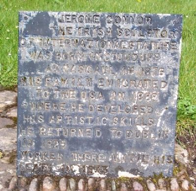
Jerome Connor Marker
| 1 ► Ireland, Munster, County Kerry, Anascaul — Jerome Connor — Dealbhoir Cumdubh Abhanascaul — 1876 - 1943 — |
| On National Road 86, on the right when traveling west. | |||
| 2 ► Ireland, Munster, County Kerry, Anascaul — Tom Crean — Antarctic Explorer — 1877 - 1938 — |
| 3 ► Ireland, Munster, County Kerry, Beenarourke — Colonel Patrick J. Quinlan — |
| On Ring of Kerry (National Route N70), on the left when traveling west. | |||
| 4 ► Ireland, Munster, County Kerry, Beenarourke — Com an Chiste — |
| On National Route N70, on the left when traveling west. | |||
| 5 ► Ireland, Munster, County Kerry, Caherdaniel — Bóthar an Ime / Bóthar an Chuinsailéara — Butter Road / Daniel O'Connell's Road — |
| On Ring of Kerry (National Route N70) at Butter Road, on the right when traveling north on Ring of Kerry. | |||
| 6 ► Ireland, Munster, County Kerry, Caherdaniel — The Sun / An ghrian — |
| On Ring of Kerry (National Route N70) at Butter Road, on the right when traveling north on Ring of Kerry. | |||
| 7 ► Ireland, Munster, County Kerry, Cahersiveen — Atlantic College of Wireless & Cable Telegraphy — 1911 • 1919 — Atlantic Telegraph Cables Trail .1857-1966. Stop C5 — |
| On Brendan's Terrace, 0.2 kilometers east of Bridge Street, on the right when traveling east. | |||
| 8 ► Ireland, Munster, County Kerry, Cahersiveen — Monsignor Hugh O'Flaherty — 1898 - 1963 — |
| On O'Connell Street just north of Church Street/Ring of Kerry (National Route N70), on the right when traveling north. | |||
| 9 ► Ireland, Munster, County Kerry, Cahersiveen — O'Connell — |
| On National Route N70 at Carhan Road, on the right when traveling east on National Route N70. | |||
| 10 ► Ireland, Munster, County Kerry, Cahersiveen — O'Connell Memorial Church — Daniel O'Connell Heritage Trail Stop 9 — |
| On Church Street/Ring of Kerry (National Route N70) just east of O'Connell Street, on the left when traveling east. | |||
| 11 ► Ireland, Munster, County Kerry, Cahersiveen — O'Connell's Birth Place — |
| On Ring of Kerry (National Route N70) at Carhan Road, on the right when traveling east on Ring of Kerry. | |||
| 12 ► Ireland, Munster, County Kerry, Cahersiveen — Presentation Convent — Daniel O'Connell Heritage Trail Stop 10 — |
| On O'Connell Street, 0.1 kilometers north of Church Street/Ring of Kerry (National Route N70), on the right when traveling north. | |||
| 13 ► Ireland, Munster, County Kerry, Cahersiveen — Primrose Walk — Daniel O'Connell Heritage Trail Stop 4 — 4A Carraig na gConnaill, 4B-D The Race Course, National School & O'Connell Church — |
| On Reenrusheen Road just east of Cois Uisce, on the left when traveling east. | |||
| 14 ► Ireland, Munster, County Kerry, Cahersiveen — Railway and O'Connell — Daniel O'Connell Heritage Trail Stop 2 — |
| 15 ► Ireland, Munster, County Kerry, Cahersiveen — Ringforts — |
| On Brendan's Terrace, 0.3 kilometers east of Bridge Street, on the left when traveling east. | |||
| 16 ► Ireland, Munster, County Kerry, Cahersiveen — Sive Fort — Daniel O'Connell Heritage Trail Stop 3 — |
| 17 ► Ireland, Munster, County Kerry, Cahersiveen — The Abbey of the Holy Cross — |
| On Carhan Road just south of Ring of Kerry (National Route N70), on the left when traveling south. | |||
| 18 ► Ireland, Munster, County Kerry, Cahersiveen — The Barracks Heritage Centre — Daniel O'Connell Heritage Trail Stop 1 — |
| On Bridge Street, 0.3 kilometers north of Church Street/Ring of Kerry (National Route N70), on the right when traveling north. | |||
| 19 ► Ireland, Munster, County Kerry, Cahersiveen — The Daniel O'Connell Memorial Park — Cahersiveen - Cathair Saidhbhin (the Town or Fort of Little Sive) — Twinned with Pluvigner, France. — |
| On National Route N70 at Carhan Road, on the right when traveling east on National Route N70. | |||
| 20 ► Ireland, Munster, County Kerry, Cahersiveen — The Daniel O'Connell Memorial Park — |
| On Ring of Kerry (National Route N70) just east of Carhan Road, on the left when traveling west. | |||
| 21 ► Ireland, Munster, County Kerry, Cahersiveen — The Railway — |
| 22 ► Ireland, Munster, County Kerry, Cahersiveen — War Memorial — |
| On Church Street (National Route N70) just west of Bridge Street, on the left when traveling east. | |||
| 23 ► Ireland, Munster, County Kerry, Castlecove — Church of the Most Precious Blood — |
| On Ring of Kerry (National Route N70), on the right when traveling west. | |||
| 24 ► Ireland, Munster, County Kerry, Castlemaine — Proclamation of the Irish Republic — |
| On National Route N70 at the River Maine, on the left when traveling north on National Route N70. | |||
| 25 ► Ireland, Munster, County Kerry, Coomanaspig Pass — Our Lady of Grace Grotto at Tobairin Holy Well — |
| On Skellig Ring Route, on the left when traveling north. | |||
| 26 ► Ireland, Munster, County Kerry, Derrynane More — Teach do laoch / Home for a hero — Teach Dhoire Fhíonáin / Derrynane House — |
| 27 ► Ireland, Munster, County Kerry, Dunquin — The Blaskets — |
| On Road 559, on the left when traveling north. | |||
| 28 ► Ireland, Munster, County Kerry, Fahan — Dunbeg Promontory Fort / An Dún Beag — |
| 29 ► Ireland, Munster, County Kerry, Gallarus — Gallarus Oratory / Séipéilín Ghallarais — |
| 30 ► Ireland, Munster, County Kerry, Glenbeigh — Glenbeigh — |
| On Ring of Kerry (National Route N70) at Munster Route R564, on the right when traveling east on Ring of Kerry. | |||
| 31 ► Ireland, Munster, County Kerry, Kells — John Golden and the South Kerry Fenians — 1867 - 2017 — Walk of the Ancestors — |
| On Ring of Kerry (National Route N70), on the left when traveling south. | |||
| 32 ► Ireland, Munster, County Kerry, Kenmare — Fair Green — Kenmare Heritage Town — |
| On The Square (National Route N71) just north of Henry Street, on the right when traveling north. | |||
| 33 ► Ireland, Munster, County Kerry, Kenmare — Henry Street — Kenmare Heritage Town — |
| On The Square/Main Street (National Route N71) at Henry Street, on the right when traveling south on The Square/Main Street. | |||
| 34 ► Ireland, Munster, County Kerry, Kenmare — James Joyce Pub Award — The Atlantic Bar — |
| On The Square (National Route N71) just north of Henry Street, on the left when traveling north. | |||
| 35 ► Ireland, Munster, County Kerry, Kenmare — Kenmare Heritage Town — |
| On The Square (National Route N71), on the left when traveling north. | |||
| 36 ► Ireland, Munster, County Kerry, Kenmare — Main Street — |
| On Main Street (National Route N71) at Henry Street, on the right when traveling south on Main Street. | |||
| 37 ► Ireland, Munster, County Kerry, Kenmare — The Market House — Kenmare Heritage Town — |
| On The Square (National Route N71), on the right when traveling south. | |||
| 38 ► Ireland, Munster, County Kerry, Kenmare — War of Independence — 1919-1921 — Kenmare Heritage Town — |
| On The Square (National Route N71) just north of Henry Street, on the right when traveling north. | |||
| 39 ► Ireland, Munster, County Kerry, Killorglin — The Ballykissane Drowning Tragedy: Good Friday 1916 — |
| On New Line Road/Ring of Kerry (National Route N70) just south of Mill Road (National Route N70), on the left when traveling south. | |||
| 40 ► Ireland, Munster, County Kerry, Killorglin — The Ballykissane Tragedy: Good Friday 1916 — |
| On New Line Road/Ring of Kerry (National Route N70) just south of Mill Road, on the left when traveling south. | |||
| 41 ► Ireland, Munster, County Kerry, Killorglin — Townsend Blennerhassett — In memory of — |
| On Mill Road/Ring of Kerry (National Route N70) at Market Street, on the right when traveling east on Mill Road/Ring of Kerry. | |||
| 42 ► Ireland, Munster, County Kerry, Kilmalkedar — Kilmalkedar Church / Cill Mhaoilchéadair — |
| 43 ► Ireland, Munster, County Kerry, Listowel — "River Fort" — |
| On Bridge Road (National Road 69) at the Town Square, in the median on Bridge Road. | |||
| 44 ► Ireland, Munster, County Kerry, Listowel — Maid of Erin — |
| On Main Street (National Road 69), on the right when traveling south. | |||
| 45 ► Ireland, Munster, County Kerry, Listowel — Teampaillín Bán — (The Little White Churchyard) — |
| On Ballybunion Road (Road 553) 0.2 kilometers west of John B. Keane Road, on the right when traveling west. | |||
| 46 ► Ireland, Munster, County Kerry, Moyvane, Cloonbrane — To the People of Ireland — |
| On Listowel Road. | |||
| 47 ► Ireland, Munster, County Kerry, Portmagee — Portmagee — Port Mhic Aoidh — (An Caladh) — |
| On Main Street just west of Munster Route R565, on the right when traveling west. | |||
| 48 ► Ireland, Munster, County Kerry, Portmagee — The Ferryboat — |
| On Main Street just west of Munster Route R565, on the right when traveling west. | |||
| 49 ► Ireland, Munster, County Kerry, Portmagee — Tomás Rua Ó Súilleabháin — (1785 - 1848) — |
| On Main Street just west of Munster Route R565, on the right when traveling west. | |||
| 50 ► Ireland, Munster, County Kerry, Reask — Reask Monastic Site / Láthair Mhainistreach an Riaisc — |
| 51 ► Ireland, Munster, County Kerry, Sneem — Catherine (Brennan) Mulvihille — |
| On Ring of Kerry (National Route N70), on the left when traveling east. | |||
| 52 ► Ireland, Munster, County Kerry, Sneem — Cearbhall ó Dálaigh — (1911-1978) — National Memorial — |
| On Ring of Kerry (National Route N70), on the left when traveling east. | |||
| 53 ► Ireland, Munster, County Kerry, Sneem — Charles de Gaulle — 1890-1970 — |
| On Ring of Kerry (National Route N70) at Sportsfield Road, on the left when traveling east on Ring of Kerry. | |||
| 54 ► Ireland, Munster, County Kerry, Sneem — John Egan — 1952 - 2012 — |
| On Ring of Kerry (National Route N70) at Church Street, on the left when traveling east on Ring of Kerry. | |||
| 55 ► Ireland, Munster, County Kerry, Sneem — Steve (Crusher) Casey — |
| On Munster Route R568 just north of Ring of Kerry (National Route N70), on the left when traveling north. | |||
| 56 ► Ireland, Munster, County Kerry, Sneem — The Peaceful Panda — |
| On Ring of Kerry (National Route N70) at Quay Road, on the right when traveling east on Ring of Kerry. | |||
| 57 ► Ireland, Munster, County Kerry, Sneem — The Steel Tree — |
| On Ring of Kerry (National Route N70) at Sportsfield Road, on the left when traveling east on Ring of Kerry. | |||
| 58 ► Ireland, Munster, County Kerry, Sneem — World War I Memorial — Ar dheis Dé go raiðh a n-anam — May their souls be at the right hand of God — |
| On Ring of Kerry (National Route N70) at Church Street, on the left when traveling west on Ring of Kerry. | |||
| 59 ► Ireland, Munster, County Kerry, Staigue — Cathair na Stéige / Staigue Fort — |
| 60 ► Ireland, Munster, County Kerry, Waterville — Charlie Chaplin — |
| On Ring of Kerry (National Route N70) just north of Southview Terrace, on the left when traveling north. | |||
| 61 ► Ireland, Munster, County Kerry, Waterville — Commercial Cable Company — 1884 - 1962 — Waterville Station — |
| On National Route N70 at Iveragh Terrace, on the right when traveling north on National Route N70. | |||
| 62 ► Ireland, Munster, County Kerry, Waterville — Dr. Thomas George Millerick 1864-1898 — |
| On Ring of Kerry (National Route N70) at Southview Terrace, on the left when traveling north on Ring of Kerry. | |||
| 63 ► Ireland, Munster, County Kerry, Waterville — Iveragh Lodge — |
| On Iveragh Terrace, on the left when traveling north. | |||
| 64 ► Ireland, Munster, County Kerry, Waterville — Iveragh Lodge • Commercial Cable Company 1st Offices — Commercial Cable Company • 1899-1964 — Atlantic Telegraph Cables Trail .1857-1966. Stop WV8 |
| On Iveragh Terrace, on the left when traveling north. Reported missing. | |||
| 65 ► Ireland, Munster, County Kerry, Waterville — Latitude 51 49' 50"·54 N. Longitude 10 10' 15"·5 W. — |
| On Iveragh Terrace, on the right when traveling north. | |||
| 66 ► Ireland, Munster, County Kerry, Waterville — Latitude and Longitude Stone 1892 — Changing the Clocks of North America & Beyond! — Atlantic Telegraph Cables Trail .1857-1966. Stop WV9 |
| On Iveragh Terrace, on the right when traveling north. Reported missing. | |||
| 67 ► Ireland, Munster, County Kerry, Waterville — Mick O'Dwyer — |
| On National Route N70, 0.1 kilometers north of Southview Terrace, on the left when traveling north. | |||
| 68 ► Ireland, Munster, County Kerry, Waterville — New Office — Commercial Cable Company • 1899-1964 — Atlantic Telegraph Cables Trail • 1857-1966 • Stop WV7 |
| On Iveragh Terrace, 0.1 kilometers east of Ring of Kerry (National Route N70), on the right when traveling east. Reported missing. | |||