587 entries match your criteria. Entries 101 through 200 are listed.⊲ Previous 100 — Next 100 ⊳
Indiana Historical Bureau Markers
State historical markers commemorate significant individuals, organizations, places, and events in Indiana history. These markers help communities throughout the state promote, preserve, and present their history for the education and enjoyment of residents and tourists of all ages.
New Albany's second city cemetery, Northern Burial Ground, was officially created July 30, 1841 when D. W. and Margaret Wilson sold land to the city. The first burial took place the following day. In 1864 and 1875, the city made additions and . . . — — Map (db m206991) HM
As part of a system of extension centers across the state, Indiana University established the Falls City Area Center in Jeffersonville in 1941 to offer IU classes locally. With the expansion of the WWII defense industry along the Ohio River, the . . . — — Map (db m206979) HM
Lucy, born a slave April 10, 1838, was owned by the Higgs family that by 1850 lived near Bolivar, Tennessee. She gained her freedom in 1862 by escaping to the 23rd Regiment, Indiana Volunteers camped nearby. She worked as a nurse for the soldiers . . . — — Map (db m46622) HM
Built 1864 for Kerr (1827-1876), an attorney. Served five terms in the United States House of Representatives, 1865-1873 and 1875-1876. Elected Speaker of the House in 1875, the third Hoosier to serve in that capacity. — — Map (db m207004) HM
[side 1] In summer 1862, national newspapers reported violence against blacks in Toledo, Cincinnati, Chicago, and New Albany, where on July 21, a fight between black and white men sparked two days of attacks by white mobs on blacks and their . . . — — Map (db m180404) HM
Founded 1813 along Ohio River by Joel, Nathaniel, and Abner Scribner. During 1840s and 1850s, New Albany was largest city and leading commercial and industrial center in Indiana. Industries included shipbuilding; glass and ironworks; hosiery, . . . — — Map (db m207048) HM
Founded 1813 along Ohio River by Joel, Nathaniel, and Abner Scribner. During 1840s and 1850s, New Albany was largest city and leading commercial and industrial center in Indiana. Industries included shipbuilding; glass and ironworks; hosiery, . . . — — Map (db m180492) HM
Railroad organized 1847, after years of legislation to provide transportation to move goods and people to and from the state's interior. Completed to Michigan City 1854 when last rail was laid in Putnam County. New Albany's economy expanded with the . . . — — Map (db m206987) HM
[side 1] New Albany lots were advertised for sale 1813. It was designated county seat 1819, incorporated as town 1836, then as city 1839. Area within the district was part of early plat of New Albany. District boundaries are roughly West 1st . . . — — Map (db m180493) HM
Tornado struck city at approximately 3:30 p.m. March 23, 1917. Moved through north side of town, affecting roughly ninety blocks. Mayor and others formed Citizens Relief Committee. Next morning Red Cross joined forces with Committee; within hours, . . . — — Map (db m206985) HM
Side 'One'
New Albany School Board organized a public library on May 8, 1884. This library building, supported with funds from Andrew Carnegie, opened on March 2, 1904 with 11, 125 volumes. Building is Neoclassical style, constructed of brick . . . — — Map (db m46768) HM
In 1880, an 1822 school building on this site became Scribner High School for African-American students, under an 1869 Indiana law mandating public education for African-American children and allowing segregated schools. Modern facility completed . . . — — Map (db m46624) HM
Five Indiana regiments were formed at this rendezvous point in 1846-1847 for service in the Mexican War. The first 3,000 men departed for active duty under Brigadier-General Joseph Lane during July, 1846. — — Map (db m206973) HM
Second state bank was established in 1834 by General Assembly with ten branch banks; one of the most successful banks at the time in U.S. This Greek Revival Style structure, built 1837, housed New Albany branch, serving Floyd, Harrison, Washington, . . . — — Map (db m180504) HM
In fall 1846, residents of Covington and Attica skirmished at Lock 35 over lack of water to Covington. Heavy rains eventually resolved the problem. Competition among canal towns over water control was often intense. First boat reached Attica 1846 . . . — — Map (db m3284) HM
Ladies Library Association of Attica, created 1885, deeded its library building to city; city library opened 1902 with a collection of 1,500 books. Funds from Andrew Carnegie made it possible to build a new library here on land originally owned . . . — — Map (db m3317) HM
American Indians frequented this area, rich in natural resources. The ravine provided water from natural springs, marl for lime, and clay for bricks for nineteenth-century residents of Attica, platted 1825. City became owner of ravine 1906 when . . . — — Map (db m3311) HM
The 1st wife of Governor David Wallace and Mother of General Lew Wallace, soldier, author of Ben Hur, statesman & diplomat, is here buried. She influenced the lives of two important Hoosiers. — — Map (db m3382) HM
Famous orator - Representative in Congress, 1861-66, 1869-73; U.S. Senator, 1877–1897; chief promoter of the building of the Library of Congress. — — Map (db m3232) HM
Platted 1808 along Whitewater River, Brookville was an important entry point to interior lands opened to settlement. The district's concentration of well-preserved buildings reflects the city's continued prosperity. Brookville Historic District . . . — — Map (db m44697) HM
Dedicated in 1912, starting with approximately 600 books; collections and services have expanded to meet needs of local patrons. One of 1, 679 libraries built in U.S. with funds from philanthropist Andrew Carnegie. Indiana built more Carnegie . . . — — Map (db m44694) HM
Side one
This grandstand built 1922 to seat 1, 000 and serve fans of new Brookville semi-pro team. Twenty box seats included to help pay for construction. Central platform included for community activities. Facility later used for youth . . . — — Map (db m44693) HM
One mile south is intersection of western boundary line of Treaty of Greenville, Ohio (1795) and Treaty of Grouseland, near Vincennes (1805), northeastern boundary line. By these treaties, Native American tribes ceded land to the United States . . . — — Map (db m66866) HM
Built in 1812, this is the oldest church building still on its original location in the state. Interior shows rifle openings in walls, a balcony and raised pulpit. Burial plot adjoins church. — — Map (db m44920) HM
United Brethren among earliest settlers in eastern Indiana during territorial period. Original structure, built 1831, one of first United Brethren churches in Indiana. Evangelical United Brethren Church joined Methodist Church to become United . . . — — Map (db m66867) HM
(Front Side)
Remembered for service in Confederate States of America army, 1861-1865, and "Shoupade" fortification design; fought in battles of Shiloh, Vicksburg, and Atlanta. Advocated recruitment of African Americans for CSA army. . . . — — Map (db m66860) HM
Here Edward Toner founded SOMERSET, 1816, & operated Toner's Tavern, 1816-1823, from which rallying point pioneers started west on Jacob Whetzel's Trace to the "New Purchase" of Central Indiana. — — Map (db m66859) HM
Known for flocks that darkened the sky, the passenger pigeon was once the most abundant North American bird. A population in the billions as late as 1860 was nearly zero by 1900. Communication and transportation advancements enabled market . . . — — Map (db m238484) HM
Important waterway of pioneer commerce. Built 1836 - 47 from Lawrenceburg to Hagerstown, with branch to Cincinnati. Used until 1860. Fifteen-mile section restored by state. — — Map (db m44708) HM
(Front Side)
Built 1894-1895 over Johnson's Fork Creek by John H. Horn and William H. Butts to a Howe truss design by John Burkhart. All men were local residents. Bridge was important passageway to Cincinnati markets. Rests on stone . . . — — Map (db m66868) HM
Extending from Michigan City to the Ohio River at Madison. Begun by the state in 1832 with funds obtained from sale of land granted by the Potawatomi Indians. Opened northern part of state to settlers. — — Map (db m35346) HM
Side 'One'
Born 1799 in North Carolina. Purchased land 1818 in Gibson County. Cockrum and Jacob Warrick Hargrove laid out the town of Oakland (now Oakland City) on January 15, 1856. Cockrum and his son William Monroe Cockrum, along with . . . — — Map (db m47807) HM
By 1862, the Union Army’s need for new recruits could no longer be met by volunteers; in March 1863, U.S. Congress passed the Enrollment Act authorizing a national draft. Drafted or enrolled men of means could hire substitutes to serve in their . . . — — Map (db m238485) HM
Side 'One'
Settled in late 1840s by Joshua and Sanford Lyles, former slaves from Tennessee. African Methodist Episcopal Church (since 1860) and schools (1865-1958) played important roles in sustaining the community. On land donated by Joshua . . . — — Map (db m47805) HM
Built circa 1888. Occupied by civic leaders (Nixon Winslow, Levi Scott, and Joseph Patterson) who made significant contributions to Fairmount's economic, educational, and cultural development. Patterson was community's medical doctor, 1889-1913. . . . — — Map (db m63799) HM
This Richardsonian Romanesque style structure, built 1900-1902, reflects the area's prosperity during the natural gas boom. The town of Harrisburg had been renamed Gas City in 1892. — — Map (db m63801) HM
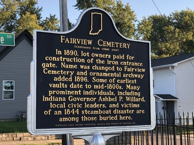
The largest Indian cemetery in Indiana. Few graves are marked. The Indians buried here are largely descendants of Chief Metocinya and include Meshingomesia and his family. The first burial was probably in 1873. Burial was contrary to Indian . . . — — Map (db m182607) HM
As Black residents left nearby Weaver Settlement for jobs in Marion, Rev. G. W. Shelton began organizing a church on the southside of the city in 1899. In 1901, the congregation purchased the building here. Over 600 people helped dedicate the church . . . — — Map (db m231185) HM
Site of battle fought Dec. 18, 1812, in which British-allied Miami Indians were defeated by U.S. troops and Militia under Col. John Campbell. — — Map (db m208561) HM
Side 1
Tracklayers building narrow gauge railroad connecting Great Lakes at Toledo, Ohio, with Mississippi River reached this point October 1, 1880. In 1887, 2,000 men converted 206 miles of this to standard gauge railroad in 11 . . . — — Map (db m215005) HM
In October 1818, Purchasing Commissioners Lewis Cass, Benjamin Parke and Governor Jonathan Jennings acquired Indian claims on the land shown on this marker. About one-third of modern Indiana was involved in this transaction. — — Map (db m1500) HM
Samuel Plato (circa 1882-1957), African American architect and contractor, lived in Marion (circa 1903-1921). House here attributed to him; he also designed and built structures throughout the U.S. One of few black architects to win federal . . . — — Map (db m238486) HM
Black pioneers, fleeing threats to their freedom in southern slave states, settled in Grant County by the 1840s. With other free and formerly enslaved families who arrived over the following decades, they cleared and drained the forested, swampy . . . — — Map (db m168285) HM
Trask, like other pioneer villages, served an important commercial, social, and educational role for early settlers. The post office (1846-1901) marked the start and end of Trask's official existence. As travel improved, such villages disappeared or . . . — — Map (db m215000) HM
Built 1883 by A.M. Kennedy and Sons to Burr arch truss design on stone abutments. Closed 1957; opened 1967 after foundation and roof rehabilitation; closed 1990. Bridge reopened 1998 following extensive structural renovation and replacement of . . . — — Map (db m98962) HM
Born in Worthington 1875. Left home at sixteen and became performer, composer, and bandmaster for several circuses, including Ringling Brothers (1902-1904, 1907) and Barnum and Bailey (1908-1910). Brought his publishing company to Worthington 1923; . . . — — Map (db m21728) HM
Kokomo native Ryan White was diagnosed with AIDS in 1984 after contracting the virus from a contaminated hemophilia treatment. He faced intense discrimination from his community in a time of fear and misunderstanding about AIDS and was prevented . . . — — Map (db m216621) HM
Free people of color left the South starting in the 1820s as threats to freedom and property escalated with slavery expansion. In 1835, Hansel and Elijah Roberts and Micajah Walden of North Carolina bought land in Hamilton County near anti-slavery . . . — — Map (db m98840) HM
By the early 1900s, Indianapolis was home to multiple medical education institutions which required corpses for dissection-based learning. Extant laws failed to provide enough bodies for this use, generating a lucrative black market. In 1902, . . . — — Map (db m210940) HM
Hamilton County formed 1823. Noblesville platted 1823, selected county seat 1824, incorporated 1851. Located east of downtown commercial area; boundaries are Conner and Logan streets (east and west) and 10th and 17th streets (north and south). . . . — — Map (db m240) HM
Norman Norell, 1900-1972. Fashion designer Norman (Levinson) Norell was born near here. The Levinsons settled in Noblesville in 1857 and opened a men’s clothing store. They relocated to Indianapolis in 1907, where theater productions inspired . . . — — Map (db m210939) HM
First bridge spanning White River at Potter's Ford was commissioned 1860 and named after the landowner, William Potter. In 1870, Hamilton County Commissioners voted for construction of this "Howe Truss" bridge. It was finished 1871 and . . . — — Map (db m8165) HM
These canal-bed earthworks are remnants of construction on the Central Canal from 1836-39. It was planned to link the Hoosier interior with interstate markets, via the Wabash & Erie Canal, as part of the 1836 Internal Improvement Act. Indiana's . . . — — Map (db m41624) HM
In 1837, an enslaved family of three escaped from Missouri; settled six miles north of here 1839 with name Rhodes. In 1844, Singleton Vaughn arrived at their home to claim them; family resisted until neighbors arrived. Vaughn agreed to take . . . — — Map (db m216703) HM
The use of the rooster as a Democratic party symbol originated in Greenfield in the 1840 campaign. The rooster was later adopted by the state and national Democratic parties. — — Map (db m273) HM
Birthplace
James Whitcomb Riley
“The Hoosier Poet”
October 7, 1849–July 22, 1916
Editor, author, poet, lecturer and entertainer. One of the best known Hoosiers of all time, Riley first wrote under the name "Benj. F. Johnson of Boone" . . . — — Map (db m213261) HM
A force of about 400, Indiana militia and citizen volunteers commanded by Col. Lewis Jordan, engaged John Hunt Morgan's raiders, 2,400 cavalry, along a wooded ridge a mile south of Corydon. The determined Hoosier defense caused General Duke, . . . — — Map (db m9636) HM
First burials date back to founding of Corydon 1808. Col. Thomas L. Posey, a public minded citizen, donated the original ground to the Town of Corydon for burial purposes. The Farquar family added a small addition and the remainder of the cemetery . . . — — Map (db m9718) HM
Site of the first Methodist church, Corydon. Lot purchased from Isaiah Boone, son of Squire Boone, in 1826. Earlier, Corydon was a station on Silver Creed Methodist Circuit. Services were held in Corydon as early as 1816. — — Map (db m9716) HM
Corydon became the first state capital of Indiana in 1816. The first constitution was drawn up and the first sessions of the state legislature and supreme court convened here. — — Map (db m198385) HM
Built 1817. Housed offices of State Treasurer and Auditor until Fall of 1824. The cellar was the Treasury vault. Building used by Harrison County Seminary, 1829-51. Since 1871, home of Amzi Brewster heirs. — — Map (db m241644) HM
Home of Governor William Hendricks 1822-1825 while he was Governor of Indiana. Front room was Governor's Headquarters. Hendricks was also Secretary of Constitutional Convention. House wa built 1817 by Davis Floyd, Territorial Auditor and Treasurer . . . — — Map (db m9711) HM
Organized 1808 from parts of Knox and Clark Counties. Named in honor of William Henry Harrison who owned land within the County and was Territorial Governor and later ninth President of U.S.
Fourth County formed in Indiana Territory. Original . . . — — Map (db m9750) HM
First Log Jail erected 1809. Spier Spencer, First Sheriff, was killed 1811 commanding the Harrison County Yellow Jackets in the Battle of Tippecanoe.
During first twelve years, Harrison County had a whipping post where justice was meted out by . . . — — Map (db m9628) HM
The Capital of Indiana Territory was moved to Corydon from Vincennes, 1813.
This building became first State Capitol, 1816.
Offices were moved to Indianapolis in 1825. — — Map (db m9626) HM
Shields, born 1769 in Virginia, served as a private for the entire Lewis and Clark Expedition from October 19, 1803 until October 10, 1806; one of its "Nine Young Men from Kentucky," he was a skilled gunsmith and blacksmith.
The Corps of . . . — — Map (db m9642) HM
Facility built 1891 as elementary and secondary school for African Americans. Originally known as Corydon Colored School; first graduation was on May 14, 1897.
Renamed 1987 for Leora Brown Farrow, a teacher at the school, 1924 - 1950. . . . — — Map (db m9627) HM
Rev. George Forster preached to Lutherans in Harrison County as early as 1805. Mt. Solomon Church was organized in 1810 four miles southwest of this spot and is credited as being the first Lutheran Church established in Indiana. — — Map (db m207095) HM
Front side
Born in Maryland early 1810's. Bought land in Corydon, May 1849. In November 1857, Kentuckians arrested Wright and two white men, Charles and David Bell; they were indicted and jailed in Kentucky for aiding escape of fugitive . . . — — Map (db m9615) HM
Polly Strong was born into slavery circa 1796 in the Northwest Territory. Vincennes innkeeper Hyacinthe Lasselle purchased her circa 1806. Although the 1816 Indiana Constitution prohibited slavery and involuntary servitude, in 1820, Strong and . . . — — Map (db m238487) HM
Built 1817 - - Home of Col. Thomas Posey, son of Gov. Posey. Col. Posey (1792 - 1863) served as Treasurer of Harrison County; Cashier of Corydon Branch of the Bank of Vincennes; U.S. Military Pension Agent in Indiana; Adjutant General of Indiana; . . . — — Map (db m241643) HM
Organized under Louisville Presbytery, Synod of Kentucky, January 1819 by Rev. John Finley Crowe who later founded Hanover College. Early Church services were held in homes and in State Capitol prior to building first church 1826. Original church . . . — — Map (db m9713) HM
Side one
Free blacks and former slaves organized an African Methodist Episcopal congregation in Corydon by 1843. In 1851, church trustees purchased land in Corydon in order to build a church and for school purposes. In 1878, church . . . — — Map (db m9752) HM
Union General in the Civil War; U.S. District Judge; Postmaster General under President Arthur; Interim U.S. Secretary of Treasury in 1884; U.S. Secretary of State under President Cleveland. Was born in Lanesville in 1832, and lived in Corydon for . . . — — Map (db m207057) HM
(Side One)
Born 1878 in Pecksburg (which was 2.1 miles east). Elected to Board of Controls of Indiana High School Athletic Association (IHSAA) 1911, appointed Permanent Secretary 1913, continued after 1929 as Commissioner of High School . . . — — Map (db m69349) HM
Adrian A. Parsons A Civil War veteran, Parsons engaged in diversified farming near here in 1884. In 1890s, he began purposeful, sustained cultivation of soybeans used for forage and fertilizer on his farm. Soybeans were not widely grown in U.S. . . . — — Map (db m232186) HM
Organized 1876 at Ladoga as second private Indiana normal school specializing in teacher training. Based on Alfred Holbrook's techniques at his normal college in Lebanon, Ohio which pioneered teacher training in America. Central Normal College was . . . — — Map (db m239) HM
(Side one):
At May 1902 meeting newly-formed Library Board authorized lot purchase and tax levy to support a public library as required by philanthropist Andrew Carnegie for funding. Designed by S. C. Dark of Indianapolis in Classical . . . — — Map (db m238) HM
(Side One) Residential district bounded by Main, East, Cross, and Marion streets. Nineteenth and early twentieth century homes reflect social and economic diversity of residents, including town’s prominent citizens. Listed in National Register of . . . — — Map (db m237) HM
(Side One)
He was born in Danville March 5, 1860 and educated in Danville Graded School. He played for Danville Browns baseball team in 1883 and for Evansville and Indianapolis minor league ball clubs 1884 and 1885. He played for . . . — — Map (db m69351) HM
has been the site of annual meeting of Religious Society of Friends since 1858. The Depository was erected to house Quaker records, 1873. Friends Central Academy served as secondary school, 1881-1919. — — Map (db m69404) HM
Seth Hinshaw, (1787-1865), well-known abolitionist, operated a station of the Underground Railroad on this site, prior to the Civil War. He also operated a store in which he refused to sell goods produced by slave labor. In 1843, Hinshaw helped . . . — — Map (db m63804) HM
Co-inventor of the airplane with his brother, Orville, he began studying flight, 1896; built first model airplane, 1899; began gliding, 1900; and achieved first successful powered flight at Kitty Hawk, North Carolina, December 17, 1903. — — Map (db m4664) HM
Here on July 4, 1894, Elwood Haynes made the first test run of an automobile which he designed and built. His car reached a speed of about seven miles per hour over a six mile course on the Pumpkinvine Pike. — — Map (db m1455) HM
(Side 1)
Canal Landing on Washington Street. The Huntington Landing started 120 feet west on Washington St and continued to the lock at Cherry St. The Wabash & Erie canal was 4 feet deep and 100 feet wide as this point. Other locks . . . — — Map (db m65223) HM
Drover Town, the first addition south of the Little River was platted Aug. 22, 1857 by Henry Drover. It included about 20 of his 160 acres of woodland. Family first names were given to the streets. Additional subdivisions followed. Huntington's . . . — — Map (db m55693) HM
Pioneering cryptanalyst Elizebeth Friedman was born in Huntington. She developed her skill in codebreaking while searching for supposed hidden messages Shakespeare’s plays at Riverbank Laboratories in Illinois in the 1910s. There, she and her . . . — — Map (db m238488) HM
The junction of the Wabash and Little rivers, 100 yards south, was the western terminus of the Maumee-Wabash long portage and, in 1835, of the first section of the Wabash and Erie Canal. During the 18th century French and English traders passed this . . . — — Map (db m45118) HM
Jean Baptiste Richardville
(Pe-she-wah), 1761-1841
last great chief of the Miamis, made the forks of the Wabash his principal residence. His mother was the influential Tau-cum-wah sister of Chief Little Turtle. — — Map (db m7541) HM
(Side 1)
Huntington's Ford and First Bridge
Pioneers forded Little River From Charles Street diagonally across just below the Island to the Court House. A dugout canoe, when hailed, carried pedestrians across for 50 cents. . . . — — Map (db m65224) HM
Huntington, the “Lime City.” so named for its many limestone quarries and kilns, the first kiln being built in this vicinity by Michael Houseman in 1843 or 1844. By 1885 there were 31 kilns in operation: eight were perpetual kilns, the . . . — — Map (db m7544) HM
Pioneering cryptanalyst Elizabeth Smith Friedman was born in Huntington. She developed her skill in codebreaking while searching for supposed hidden messages in Shakespeare's plays at Riverbank Laboratories in Illinois in the 1910s. There, she . . . — — Map (db m220229) HM
(Side 1) Pioneer Medical Doctors. George A. Osborn, 1823-1902, Margaret Osborn, 1827-1914, Parents of Chase S. Osborn. The mother launched upon active practice here 1860. The father practiced in Ohio before 1850.
(Side 2) . . . — — Map (db m61750) HM
(Front Side)
Born 1810 in what is now Huntington County. She was a granddaughter of Miami Chief Little Turtle. Her second husband was Antoine Revarre; her son Anthony Revarre, lived with her near Roanoke and acted as interpreter since . . . — — Map (db m61120) HM
First lock west of summit level of Wabash and Erie Canal (connected Lake Erie with Ohio River in 1853). Known as Dickey Lock. Built as Lock 1, 1834-1835, of wood construction; renumbered Lock 4 as result of canal completion to Ohio line (1840). . . . — — Map (db m61119) HM
Side A A Warren Public Library Board was organized in June 1916 after a public fundraising campaign to buy books and periodicals. In 1917, a grant of $10,000 from the Carnegie Corporation was confirmed to support construction of a free . . . — — Map (db m41467) HM
In Memory of Col. John Ketcham
1782 - 1865
Fearless pioneer, Ranger, surveyor, public servant who dedicated this public square for seat of government of Jackson County, Ind. when Brownstown was founded April 8, 1816.
Time Capsule . . . — — Map (db m46756) HM
587 entries matched your criteria. Entries 101 through 200 are listed above. ⊲ Previous 100 — Next 100 ⊳