By Duane and Tracy Marsteller, June 24, 2023
North Carolina side of marker
GEOGRAPHIC SORT Title Sort Marker Number Sort Marker Number Sort N Marker Number Sort T Publication Order Sort Publication Order Sort A Erected Year Sort Most Viewed Sort Most Recent-Interest Sort Most Recently Changed Sort SEE FAQ #33 FOR DESCRIPTIONS
On State Highway 16, 0.1 miles north of Charles Spencer Road (County Route 1534), on the right when traveling north.
On State Highway 91, 1.6 miles south of Jeb Stuart Highway (U.S. 58), on the right when traveling south.
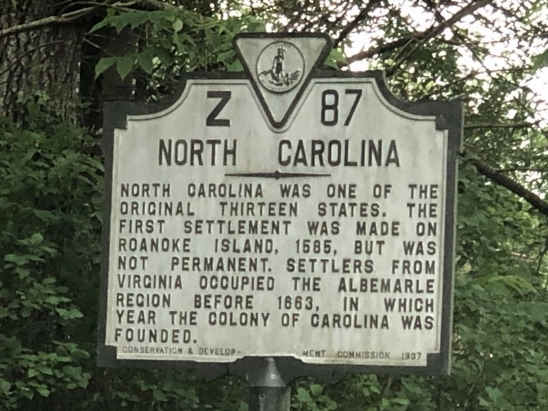
On Alt. US 13 Front Street at Courthouse Ave., on the right when traveling north on Alt. US 13 Front Street.
On Courthouse Ave. (County Route 764) 0.1 miles north of Front Street (Alternate U.S. 13), on the right when traveling west.
On Alt. US 13 Front Street at T. C. Walker Drive, on the right when traveling north on Alt. US 13 Front Street.
On Lankford Highway (U.S. 13) at Savagetown Road (Virginia Route 603), on the right when traveling south on Lankford Highway.
On U.S. 13 at County Line Road, on the right when traveling north on U.S. 13.
On Adams Crossing Road at US 13, on the right when traveling east on Adams Crossing Road.
On Adams Crossing Road at US 13, on the right when traveling east on Adams Crossing Road.
On US 13 at W. Main Street, on the left when traveling north on US 13.
On County Line Road at County Line Road, on the right when traveling north on County Line Road.
On Bobtown Road Rt 178, 0.2 miles north of St. George Circle, on the right when traveling north.
On Main Ridge Road near Thomas Road, on the left when traveling north.
On Main Ridge Road near Ponderosa Lane.
On Main Ridge Road at Pondarosa Road and Twin John Road, on the right when traveling south on Main Ridge Road.
Paid Advertisement
On US 13 north of Saxis Road, on the left when traveling north.
On Chincoteague Road (Route 175) 3.4 miles east of Fleming Road (Virginia Route 679), on the right when traveling east.
On Rockfish Gap Turnpike (U.S. 250) east of Afton Mountain Road (Virginia Route 6), on the right when traveling west.
On Seminole Trail (U.S. 29) north of Frays Mill Road / Burnley Station Road, in the median. Reported missing.
On Stony Point Road (State Highway 20) at Turkey Sag Road (County Road 640), on the right when traveling west on Stony Point Road.
On Plank Road (County Route 692) just west of Miller School Road (County Route 635), on the right when traveling west.
On Gordonsville Road (Virginia Route 231) 1.5 miles Virginia Route 640, on the left when traveling north.
On Stony Point Road at Winding River Lane, on the right when traveling north on Stony Point Road.
On Stony Point Road (Virginia Route 20) just north of Richmond Road (U.S. 250), on the right when traveling north. Reported permanently removed.
On McCormick Road south of University Avenue (Business U.S. 250), on the left when traveling south.
On Richmond Road (U.S. 250) 0.1 miles west of Louisa Road (Virginia Route 22), on the right when traveling west.
On McCormick Road south of University Avenue (Business U.S. 250), on the left when traveling south.
On Ivy Road (Business U.S. 250) near Colonnade Drive.
On Ivy Road (Business U.S. 250) near Colonnade Drive. Reported permanently removed.
On Ivy Road (Business U.S. 250) just west of Colonnade Drive, on the right when traveling east.
On Advance Mills Road (County Route 743) at Frays Mill Road (County Route 641), on the left when traveling west on Advance Mills Road.
Paid Advertisement
On Barracks Farm Road (County Route 658) east of Garthfield Lane, on the right when traveling east.
On Emmet Street North (Business U.S. 29) at University Avenue and Ivy Road (Business U.S. 250), on the left when traveling south on Emmet Street North.
On University Avenue (Business U.S. 250) at Rugby Road on University Avenue.
On Scottsville Road (Virginia Route 20) just south of Carters Mountain Road (Route 627), on the left when traveling south.
Near Woodbrook Drive west of Seminole Trail (U.S. 29).
On Louisa Road (Virginia Route 22) 0.2 miles east of Cobham Station Lane (Virginia Route 640), on the right when traveling north.
On St John Road (Virginia Route 640) 1 mile south of Gordonsville Road (Route 231), on the right when traveling south.
On Monacan Trail Road (U.S. 29) at Lackey Lane (County Route 838), on the right when traveling south on Monacan Trail Road.
On Crozet Avenue (Virginia Route 240) at The Square (Local Route 1217), on the left when traveling south on Crozet Avenue.
On Earlysville Road (County Route 743) just south of Advance Mills Road (County Route 663), on the left when traveling north.
On Rio Mills Road (County Route 643) at Seminole Trail (U.S. 29), on the right when traveling west on Rio Mills Road.
On Rio Mills Road (County Route 643) at Seminole Road (U.S. 29), on the right when traveling west on Rio Mills Road.
On Louisa Road (Virginia Route 22) 0.1 miles west of Whitlock Road (Virginia Route 616), on the left when traveling west.
On Rockfish Gap Turnpike (U.S. 250) east of Plank Road, on the right when traveling east.
On Ivy Road (U.S. 250) at Owensville Road (County Route 678) on Ivy Road.
On Ivy Road (U.S. 250) east of Three Notched Road (Virginia Route 240). Reported missing.
Paid Advertisement
On Ivy Road (U.S. 250) 0.1 miles west of Gillums Ridge Road (Virginia Route 787), on the right when traveling west.
On Gordonsville Road (Route 231) 0.1 miles south of Millwood Lane (County Road 783), on the left when traveling south.
On Louisa Road (U.S. 22) at Keswick Road (County Route 731), on the right when traveling west on Louisa Road.
On Virginia Route 231 north of Lindsay Road, on the left when traveling north.
On Miller School Road (County Route 635) close to Dick Woods Road (County Route 637), on the left when traveling south.
On Proffit Road (County Route 649) near Mossing Ford Lane (County Route 741), on the right when traveling south.
On Belvedere Boulevard, 0.1 miles east of Belvedere Place, on the right when traveling east.
On East Main Street (Virginia Route 6) east of Valley Street (Virginia Route 20), on the left when traveling east.
On Irish Road (Virginia Route 6) at James River Road, on the right when traveling west on Irish Road.
On Valley Street (Virginia Route 20) at Main Street (Virginia Route 6), on the left on Valley Street.
On James River Road (Virginia Route 742) 0.2 miles east of Warren Ferry Road, on the right when traveling east.
On Hatton Ferry Road, 0.2 miles south of Hatton Ferry Lane, on the left when traveling south.
On Richmond Road (U.S. 250) at Louisa Road (Virginia Route 22), on the right when traveling west on Richmond Road. Reported permanently removed.
On Richmond Road (U.S. 250) east of Exit 124 (Interstate 64), on the right when traveling east.
On James Monroe Parkway (County Route 795) 0.8 miles south of Thomas Jefferson Parkway (Virginia Route 53), on the left when traveling south.
On Thomas Jefferson Highway (Virginia Route 53) just east of Milton Road (County Route 732), on the right when traveling east. Reported permanently removed.
Paid Advertisement
On Thomas Jefferson Parkway (Virginia Route 53) just south of Colle Lane, on the right when traveling south.
On King Street (Virginia Route 7) near South Taylor Street, on the right when traveling east.
On King Street (Virginia Route 7) near South Taylor Street, on the right when traveling east.
On King Street at North Fairfax Street, on the left when traveling east on King Street.
On South Royal Street at Jones Point Drive, on the left when traveling south on South Royal Street.
On Oronoco Street east of North Washington Street (Virginia Route 400), on the right when traveling east. Reported permanently removed.
On Oronoco Street just east of North Washington Street, on the right when traveling west.
On North Royal Street at Cameron Street, on the right when traveling north on North Royal Street.
On N. Washington Street at Queen St., on the right when traveling south on N. Washington Street.
On Montgomery Street just east of Richmond Highway (U.S. 1), on the left when traveling west.
On Oronoco Street at North Washington Street (Virginia Route 400), on the right when traveling east on Oronoco Street.
On North Washington Street (Virginia Route 400) north of Cameron Street, on the right when traveling south.
On Princess Street just east of North Patrick Street (U.S. 1), on the left when traveling east.
On Oronoco Street at North Washington Street (Virginia Route 400), on the left when traveling east on Oronoco Street.
On Mount Vernon Avenue at East Oxford Avenue, on the right when traveling south on Mount Vernon Avenue.
Paid Advertisement
On Washington Street (Virginia Route 400) at Wolfe Street, on the right when traveling north on Washington Street.
On Alfred Street at Duke Street (Virginia Route 236), on the right when traveling south on Alfred Street.
On South Washington Street north of Wolfe Street, on the right when traveling north.
On Duke Street (Virginia Route 236).
On South Washington Street (Local Route 400) at Church Street, on the right when traveling south on South Washington Street.
On Prince Street east of South West Street, on the right when traveling east.
On South Washington Street (Virginia Route 400) south of Gibbon Street, on the right when traveling north.
On Duke Street (Virginia Route 236) at South West Street, on the right when traveling west on Duke Street.
On Kanawha Trail (Virginia Route 311) 0.3 miles south of West Virginia Exit 183 (Interstate 64), on the left when traveling south.
On Main Street (Business U.S. 60) at East Ridgeway Street (Business U.S. 60), on the right when traveling west on Main Street.
On Grafton Street (Business U.S. 60) at Longdale Furnace Road (County Route 637), on the left when traveling west on Grafton Street.
On Interstate 64, 0.6 miles east of Jerry's Run Road (Virginia Route 198), on the right when traveling east.
On U.S. 220, 2.7 miles south of County Route 606, on the right when traveling north.
On Longdale Furnace Road (Virginia Route 269) at Iron Ore Lane, on the right when traveling west on Longdale Furnace Road.
On Winterbury Avenue NE (Road F-205) north of Exit 21 (Interstate 64), on the right when traveling east.
On Selma Low Moor Road (Virginia Route 696) 0.2 miles west of Oakland Drive (Virginia Route 1002), on the right when traveling west.
Paid Advertisement
On Goodes Bridge Road (Business U.S. 360) 0.1 miles east of Jefferson Street, on the right when traveling east.
On Virginia Street at Church Street, on the right when traveling south on Virginia Street.
On Church Street at Virginia Street, on the left when traveling west on Church Street.
On Saylers Creek Road (County Route 617) 0.9 miles south of James Town Road (County Route 618), on the right when traveling north.
On Patrick Henry Highway (U.S. 360) west of Mt. Zion Road (County Route 639), on the right when traveling west.
2614 entries matched your criteria. The first 100 are listed above.
Next 100 ⊳