Historic American Buildings Survey Historical Markers
The Historic American Buildings Survey (HABS) is the nation's first federal preservation program, begun in 1933, and a precursor to the National Register of Historic Places. As such, it established methodologies that are now standard practice within the field such as the surveying and listing of historic sites and the creation of documentation for public benefit. It was founded through a unique private-public partnership with the National Park Service (NPS), Library of Congress (LC), and the American Institute of Architects (AIA) to record America's architectural heritage.
By Mark Hilton, October 25, 2020
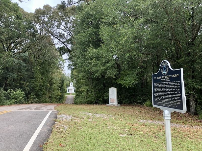
Ivy Creek Methodist Church can be see in far distance.
Constructed in 1854, Ivy Creek Methodist Church originally was part of the Mulberry Beat in Autagua County. The church served the communities of Hamilton, Huckabee (Evergreen), Milton, Statesville-Mulberry, and West Autaugaville. Ivy Creek Methodist . . . — — Map (db m158666) HM
Built by John Hart about 1850, the Hart House is recognized as an outstanding example of pure Greek Revival architecture. Hart (c. 1805-1863) moved from New Hampshire and became a prominent merchant and farmer. When constructed, the house was on the . . . — — Map (db m48376) HM
Choccolocco Park is located on land that was farmed by the Caver,
Christian and Davis families from 1840 until the late twentieth
century. During the Great Depression, the farm was documented
by the Historic American Building Survey. The subjects . . . — — Map (db m145025) HM
First Presbyterian Church was organized April 13, 1824, by Scots-Irish settlers. The sanctuary, erected in 1827, is the oldest in continuous use in Alabama. Its Georgian Gothic style remains essentially unchanged. The brick walls are laid in . . . — — Map (db m40429) HM
This notable Greek Revival structure was completed in the late 1840's on land donated by Eli Robinson. The congregation was established 1828-1830 and the first church, built of logs, was located c. 1 mile east of here. Charter members were: Rev. . . . — — Map (db m71178) HM
George Washington Foster, planter, built this Greek Revival Mansion. An Act of the legislature was required to close Court Street, In fall of 1864 it was headquarters of Nathan B. Forrest, General, CSA. Foster's daughter, Sarah Independence McDonald . . . — — Map (db m28868) HM
George Gilliam Steele, one of Huntsville's preeminent architects, designed and built Oak Place as his country residence circa 1840 on 320 acres.
An outstanding example of Early Greek Revival architecture, it was unique for the period with its . . . — — Map (db m154278) HM
Started in 1833 by James Roper on a Spanish land grant, “Oakleigh” was named for the magnificent oaks around it. The “T” shaped dwelling with elegant parlors and curved outside stairway from the brick terrace to front gallery . . . — — Map (db m85908) HM
The cannon in front of you, buried muzzle-down during an
1873 land survey to mark a corner of the Mount Vernon
Military Reservation, is just one of many reminders that Mount
Vernon hosted important U.S. Army posts throughout the 19th
century. . . . — — Map (db m149304) HM
An elegant blend of Greek Revival and Italianate architectual styles, the Thompson Mansion reflects the aesthetic and economic highs of the 1850s. The symmetrical layout of the house with entrances on all four sides features interior cross hallways . . . — — Map (db m71400) HM
Residence of many prominent Alabama families. Originally built by James Jenkins in 1822 as a two-room “cabin.” David Scott, prominent merchant and church leader, purchased the property in 1832 and added the four story brick structure. Occupied by . . . — — Map (db m203559) HM
Saint Michael's Cathedral, a National Historic Landmark, is the central point of interest in historic downtown Sitka and is recognizable statewide as the most prominent symbol of the Russian colonial presence in Alaska. It was the main edifice of a . . . — — Map (db m181574) HM
Built in 1897, this one-and-one-half story log structure served as
Skagway's first city hall and jail, the first courthouse, and the first U.S. Marshal's office. It was also the site of the land transfer for the railroad . . . — — Map (db m257763) HM
This structure has been
recorded by the
Historic American
Buildings Survey
of the United States Department
of the Interior for its
archives at the Library of Congress. — — Map (db m48526) HM
Built in 1858 by Pierre Bonet with fire proof steel shutters and stone walls. Owned and operated by Victorene Compere to provision the miners. Restored and preserved as a private residence in 1939.
Historic American Building Survey No. 1108 . . . — — Map (db m32872) HM
Dedicated to Juan Bandini
1800 – 1859
Patriot and Friend of the United States
This structure has been recorded by the
Historic American Buildings Survey of the United States Department of the Interior for its archives at the . . . — — Map (db m143529) HM
A patent for 1200 acres called Attawattacoquin, upon which the house and outbuildings stand, was granted in 1684 by Charles Calvert, 3rd Baron Baltimore, 2nd Proprietor and 6th and 9th Proprietary Governor of Maryland, to Christopher Nutter, a . . . — — Map (db m193782) HM
Home of the first Secretary of the Navy
Benjamin Stoddert
Built 1783 - 1789
Restoration & Rehabilitation
of the estate & gardens
by
Prospect Associates
Edmund W. Dreyfuss A.I.A.
Lorraine S. Dreyfuss
1982 - 1992
Historic . . . — — Map (db m211966) HM
In 1821, George MaHorney, a bricklayer, built this two room, two story frame "laborer's cottage." William W. Corcoran, a founder of the Corcoran and Riggs Bank and the Corcoran Gallery of Art, owned the property from 1853, through the Civil War, . . . — — Map (db m112144) HM
This structure has been
recorded by the
Historic American
Buildings Survey
of the United States Department
of Interior for its archives at the Library of Congress. — — Map (db m91962) HM
This structure has been
Recorded by the
Historic American
Building Survey
of the United States Department
of Interior for its archives
at the Library of Congress — — Map (db m100778) HM
This structure has been
recorded by the
Historic American
Buildings Survey
of the United States Department
of the Interior for its Archives
at the Library of Congress — — Map (db m30453) HM
The Wardlaw-Smith House was erected in the early 1860's for Benjamin F. Wardlaw, a prominent local citizen. Following the Civil War Battle of Olustee in February, 1864, it served as a Confederate hospital. This fine example of Greek Revival . . . — — Map (db m17745) HM
Bernice Dixon arrived in Key West in 1937 with her husband, Ralph Dixon, a bridge engineer. They fell in love with Key West, and Bernice opened The Beachcomber Jewelry Store on Duval Street in 1938.
A very astute and successful businesswoman, . . . — — Map (db m249795) HM
The church was organized as a mission in 1858 and was consecrated the following year by the Rt. Rev. Francis Huger Rutledge, first Bishop of Florida. During the War it was used by Federal forces occupying Fernandina and many of its interior . . . — — Map (db m58814) HM
(side 1)
In 1880, the South Florida Railroad built a railway through Orlando. The small community boomed with land speculators, citrus and cattle investors, and tourists. In 1902, the larger Atlantic Coastline Railroad acquired the South . . . — — Map (db m100895) HM
The Seaboard Air Line Railway Station has played an important role in the history of West Palm Beach and Palm Beach County. It is a unique example of early 20th century railroad architecture in the Mediterranean Revival style. The Station opened . . . — — Map (db m96762) HM
Fernando Rodriguez, sergeant in the Spanish Army at the Castillo de San Marcos Fort, built his house on this site during the first Spanish occupation (1565-1763). In 1760, he commissioned Juan Perez, Master Builder, to add the northeast coquina room . . . — — Map (db m102365) HM
[First plaque]
This property has been
placed on the
National Register
of Historic Places
by the United States
Department of the Interior
[Second plaque]
This structure has been
recorded by the
Historic American . . . — — Map (db m199975) HM
In 1840, the City hired architect Charles B. Cluskey to build part of a much-needed retaining wall along the north side of Bay Street, east of the City Exchange Building (where City Hall now stands). Cluskey used brick for his embankment wall. . . . — — Map (db m163922) HM
The Convent and Academy of Saint Vincent dePaul was opened in June, 1845. Sisters of Mercy from Charleston, S.C., under the leadership of Mother Vincent Mahoney, began a boarding school, orphanage, day school and free school. St. Vincent's Convent . . . — — Map (db m5757) HM
This structure has been recorded by the Historic American Buildings Survey of the United States Department of the Interior for its archives at the Library of Congress — — Map (db m267565) HM
This bridge was built in 1859 at a cost of $40,000 and used for nearly seventy years. Previously, travelers at Carlyle crossed the Kaskaskia by ferry or on a mud bridge supported by logs. The Historic American Buildings Survey recognized the . . . — — Map (db m98933) HM
"Although there is an occasional profile which suggests the Greek Revival, it is as [though] it were designed from a hazy memory…the atmosphere of the whole indicates a southern influence." - Historic American Buildings Survey, 1934 . . . — — Map (db m144942) HM
This structure has been
recorded by the
Historic American
Buildings Survey
of the United States Department
of the Interior for its archives
at the Library of Congress — — Map (db m121780) HM
Built by Moses R. Grinter in 1857 on the then Delaware Indian Reserve, this house was near the point where in 1831 he had begun operation of the first ferry on the Kansas River. For many years following its survey in 1837 the Fort Leavenworth - . . . — — Map (db m46338) HM
Early Smokehouse or Indian Fort? The
1975 Historic American Building Survey
states. "It is impossible to disprove
completely the building's design as a
fortification, but it is more likely that
the structure was dual purpose utility
building." . . . — — Map (db m217965) HM
One of the grandest plantation mansions ever built in Louisiana, Belle Grove was built at the pinnacle of prosperity during the 1850s sugar boom in the South. Sixty-two feet in height, her thirty foot pillars were capped by solid cypress Corinthian . . . — — Map (db m87260) HM
How was African House built?
This hut-like structure was constructed by skilled slaves in the 1820s. Their toil
included digging clay, shaping it into molds and firing to create bricks for the first
floor. The second floor was crafted with . . . — — Map (db m227883) HM
Writers In Residence Yucca House was occupied by two writers during the years
when Cammie Henry ran Melrose Plantation as an
artists' retreat.
Lyle Saxon (1891-1946) began visiting in the early 1920s, and
in 1933, he moved into Yucca . . . — — Map (db m227888) HM
Nestled on the banks of the Cane River, Natchitoches is
perhaps the most beautiful inland town in Louisiana. Founded in
1714 as a French colonial settlement, it boasts brick lined streets,
historic architecture, and a charming ambiance that . . . — — Map (db m188776) HM
This property was first recorded on a 1723 French
colonial map of Louisiana. Louis Brognier de Clouet,
a prominent Frenchman and critical figure in the
development of New Orleans acquired this land
from a Spanish land grant in 1774. The . . . — — Map (db m205279) HM
This structure has been recorded by the Historic American Buildings Survey of the United States Department of the Interior for its archives at the Library of Congress. — — Map (db m101625) HM
After being neglected for nearly a decade, the Chesapeake and Ohio Canal received new life with the New Deal programs in the late 1930s. Two African American Civilian Conservation Corps camps were setup at nearby Cabin John and Carderock to . . . — — Map (db m105328) HM
Recording the Past
In 1936, John Brostup came to Colesville to take photographs for the Historic American Buildings Survey (HABS), a New Deal federal works project established to capture pre-1860s structures on film before they disappeared. . . . — — Map (db m115372) HM
Bostwick
Built in 1746 by Christopher Lowndes
Merchant -- Ship Builder
First Postmaster
Prominent Citizen of Blandensburg
Home of Benjamin Stoddert
First Secretary U.S. Navy 1789-1801
On National Register of Historical . . . — — Map (db m65829) HM
Bostwick House is an important, but fragile, historic resource with many community, local, and statewide partners engaged in collaborative planning to restore this significant structure. One of the first efforts at preservation was in 1936 when the . . . — — Map (db m95992) HM
This 1860 building is the last of three Gothic Revival schools in Marshall. The name comes from its location on a site proposed for the Michigan state capitol. Donated to the Marshall Historical Society by the Board of Education in 1967, it is today . . . — — Map (db m177162) HM
Village of Ovid
In 1836, inhabitants of Ovid, Seneca Falls County, New York, began to settle this fertile farm area. Among them were Samuel Barker, who built his log cabin in "Section 6;" Jabez Denison, noted for his prowess in killing . . . — — Map (db m119352) HM
In 1844 Benjamin Ticknor, a U.S. naval surgeon from Connecticut, built this Classic Revival house on his 183-acre farm in Pittsfield Township. He used cobblestone construction, which originated in upstate New York. The rear wing includes a small . . . — — Map (db m101798) HM
This house, built prior to 1842 by Arden Ballard, has been recognized by the Historic American Building Survey as a model of Greek Revival architecture. The house was purchased by the Ladies' Literary Club in 1913. — — Map (db m90645) HM
This is the oldest Methodist Church building in continuous use in Minnesota. Methodist circuit riders of the Sunrise Mission served the Taylors Falls area 1852-59. On March 27, 1859, the Rev. Sias Bolles organized the Taylors Falls Methodist . . . — — Map (db m44571) HM
The Marine Township Hall was constructed in 1872 as a meeting hall and jail. The building was erected on property donated by Orange Walker. Its construction was financed by Morgan May who took the town's bonds for the necessary $2,000. Members of . . . — — Map (db m45939) HM
[Top plaque] This structure has been recorded by the Historic American Buildings Survey of the United States Department of the Interior for its archives at the Library of Congress
[Bottom plaque] This property has been placed on . . . — — Map (db m244237) HM
The Presbyterian Church in Mays Landing was constructed between 1841 and 1844 in the Greek Revival Style. Samuel Richards, owner of the Weymouth Furnace, and his wife Anna donated a lot of ground, valued at $100 and centrally located in May's . . . — — Map (db m190886) HM
This house is a fine example of Dutch Colonial architecture. The south wing of the house was built by Roelof Westervelt in 1745. The land had been purchased by his grandfather, in 1695, from the Lord Proprietores of East Jersey. The central section . . . — — Map (db m7210) HM
Stands on land purchased by William P. Christie for 500 pounds for 100 acres. In 1804 he built his home. Following his sudden death, in order to be fair to the many heirs, the house and the land were sold at auction to three buyers. In 1836 Samuel . . . — — Map (db m7209) HM
Built in 1872 when George Huyler donated the land and a third of the cost. Residents and the Northern Railroad of New Jersey shared equally in the balance. Designed in High Victorian Gothic by Architect Daniel T. Atwood, the station opened in 1874 . . . — — Map (db m7211) HM
When Frederic Church purchased the 126-acre property that would become the farm at Olana, it included an old farmhouse located on this site and a modest house facing the Oak Hill-Hudson Road. Historically known as the
Wynsant Brezie farm, it was . . . — — Map (db m175834) HM
This structure has been recorded by the Historic American Buildings Survey of the United States Department of the Interior for its archives at the Library of Congress — — Map (db m92938) HM
Whitney Mansion Built c. 1837 has been placed on the National Register of Historic Places by the United States Department of the Interior This structure has been recorded by the Historic American Buildings Survey of the United Stated . . . — — Map (db m93050) HM
Henry Dudley, Architect
Belltower Addition: 1883
Recorded in 1967 by
Historical American Building Survey
"An Historic Structure Having
Exceptional Historical and
Architectural Interest" — — Map (db m29820) HM
Top Left This is an undated picture from the collection of the Theuner family. They owned the property for a short time in the 1920's. Note the porch lanterns, probably fueled by acetylene. This was the first house in town to have working . . . — — Map (db m134007) HM
This structure has been recorded by the Historic American Buildings Survey of the United States Department of the Interior for its archives at the Library of Congress. — — Map (db m57596) HM
Theodore Elijah Burton
Born in Jefferson, Ohio, Theodore E. Burton graduated from Oberlin
College and became a prominent Cleveland attorney. He was elected
to Congress in 1888 and served from 1889-91, 1895-1909, and
1921-28. He was . . . — — Map (db m267580) HM
This structure has been
recorded by the
Historic American
Building Survey
of the United States Department
of the Interior for its archives
at the Library of Congress . . . — — Map (db m137849) HM
Overlooking the "Middlegrounds," an early site of railroad, immigration, and commercial activity, the Oliver House opened in 1859 as Toledo's premier hotel. It was designed by nationally prominent architect Isaiah Rogers, in the Greek Revival . . . — — Map (db m26003) HM
On January 19, 1835, Reverent Steven Barnes led sixteen men and women to establish the Weymouth Congregational Church at the home of Lathrop Seymour. From its beginnings, the congregation opposed slavery. In 1848, it adopted resolutions condemning . . . — — Map (db m205788) HM
Built in 1847, during the Presidency of Polk, when Perrysburg was the County Seat, and used as the Jail and Infirmary until 1870. Continued to serve as the Perrysburg Jail until 1899, sold by the town in 1918. Acquired and restored by Mr. and Mrs. . . . — — Map (db m67525) HM
This Structure Has Been
recorded by the
HISTORIC AMERICAN
BUILDINGS SURVEY
of the United States Department
of the Interior for its Archives
at the Library of Congress — — Map (db m92811) HM
This “Hall and Parlor” style house has a kitchen (Hall) and a living room (Parlor) on the first floor and two bedrooms upstairs. There are two angled fireplaces in the center-of the front wall similar to “Penn Plan” houses. It is constructed of sawn . . . — — Map (db m77079) HM
This structure has been
recorded by the
Historic American
Buildings Survey
of the United States Department
of the Interior for its Archives
at the Library of Congress — — Map (db m152229) HM
Founded in 1730. A session for an Indian treaty was held in the original church building in 1762. The present edifice was dedicated in 1766. Here are interred the remains of Thomas Wharton (1778) and Gov. Thomas Mifflin (1800). — — Map (db m5124) HM
This property has been placed on the National Register of Historic Places by the United States Department of the Interior. This structure has been recorded by the Historic American Buildings Survey by the United States Department of the Interior . . . — — Map (db m180362) HM
Welcome to Society Hill
This part of William Penn's 17th-century "green Country Towne" was owned by the Free Society of Traders, a London development company. . . . — — Map (db m267582) HM
"The Carriage House and Stable is perhaps even finer than the house with its wonderfully simple use of Federal geometric design." Edward Teitelman, Architecture in Philadelphia (1974)
This property has been
placed on the
National Register
of Historic Places
by the United States
Department of the Interior
———————
This structure has been
recorded by the
Historic . . . — — Map (db m103864) HM
Erected circa 1760 in the
old section of the city.
A rare surviving example
of its kind containing
4 finely paneled rooms
and other trim which
makes it exceptional
for a house of
its modest size.
Medallion:
Award 1967 . . . — — Map (db m51611) HM
C. 1775 and 1826
This splendid mansion was
built in 1826 by Dr. Joseph
Glover, a noted Charleston
physician, utilizing the
service wing of an older
house of about 1775. In 1906
it was purchased by the
Cavaliere Giovanni Sottile,
. . . — — Map (db m51308) HM
Bringing Sabine Hill Back to Life Sabine Hill remained in the Taylor family through the latter 1940s. In August 1936, W. Jeter Eason with the Historic American Buildings Survey (HABS) visited Sabine Hill and took detailed photographs . . . — — Map (db m174641) HM
This structure has been
recorded by the
Historic American
Building Survey
by the United States Department
of the Interior for its archive
at the Library of Congress — — Map (db m235074) HM
Mission Espada, The Southernmost of San Antonio's five Spanish missions, was established here on the west bank of the San Antonio River in 1731. The small missionary-led community first built crude huts (jacales) that were later replaced by . . . — — Map (db m213719) HM
Jonas Galusha, born in Norwich, CT in 1753, moved his family to Shaftsbury in 1775. During the Revolutionary War he served with Seth Warner's Green Mountain Boys and was at the Battle of Hubbardton and a Captain during the Battle of Bennington. A . . . — — Map (db m27799) HM
This Frontier Fort stands in mute evidence of that early American history that has gone before us. It was built around the year 1755, and it was home of one of the first settlers to the Shenandoah Valley of Virginia. Built at a time when the early . . . — — Map (db m660) HM
History of the Original Yorktown Windmill
Built in 1711 by William Buckner, the Yorktown Windmill was a guidepost on the York River for nearly two centuries. After retiring from his post as Surveyor General of Virginia, Buckner purchased . . . — — Map (db m77781) HM
Built by the Puget Mill Company in 1919, this grocery and supply store was located on the North Trunk Road in Alderwood Manor (now 196th Street SW in Lynnwood). The Main Store was a familiar landmark half-way between Seattle and Everett to . . . — — Map (db m60020) HM
This property has been
placed on the
National Register
of Historic Places
by the United States
Department of the Interior
This structure has been
recorded by the
Historic American
Buildings Survey
of the United States . . . — — Map (db m176805) HM
The congregation was organized in 1839 and this building was erected in 1851. The architect was Lucas Bradley, an elder of this church. The building has won national recognition as a superb example of the Greek Revival style. Authorities have . . . — — Map (db m253683) HM
Built in 1847 by Densmore W. Maxon, a Yankee surveyor and member of the first Wisconsin State Legislature, who constructed a dam and sawmill and platted Cedar Creek. The east wing housed the first village post office. The Greek Revival style house . . . — — Map (db m77006) HM
This building, once a stagecoach inn on the Watertown Plank Road, was built in 1843. The builder was Michael Dousman (1771-1854), a fur trader and entrepreneur from Mackinac, Michigan, with help from his son, Talbot Dousman.
Michael Dousman . . . — — Map (db m43580) HM
Built in 1858 in the Greek Revival style popular at the time, the house is built of locally quarried limestone with mortar lime coming from the lime kilns. The Miller-Davidson House, original to the site, is special in many ways beginning with the . . . — — Map (db m76227) HM
Built in 1848 by Isaac Lain, industrialist and civic leader. Next owner, 1904-1944, was Edward R. Estberg, banker and mayor.
Home of American Legion since 1944.
It is the County's finest example from the last century of the famous Greek Revival . . . — — Map (db m267574) HM