On Interstate 75 north of Ringgold Road (U.S. 76), on the right when traveling north.
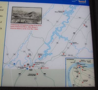
Controlling the river and railroad junction at Chattanooga was important to both North and South during the war. As a Confederate general noted, Chattanooga "commands important passes into Georgia and Alabama, and would enable the enemy ... to cut . . . — — Map (db m48198) HM
Near Cromwell Road, 0.7 miles west of Jersey Pike.
Two strategically important railroads met in Chattanooga. The Western & Atlantic Railroad (W&A) from Atlanta was finished in 1850. A few hundred yards to your left, it joined the East Tennessee & Georgia Railroad (ET&G), which was completed from . . . — — Map (db m134925) HM
On Signal Mountain Road (Tennessee Route 8) at Lullwater Road, on the right when traveling west on Signal Mountain Road.
After the Battle of Chickamauga in September 1863, Union Gen. William S. Rosecrans retreated to Federal-occupied Chattanooga, a strategically vital rail center, where Confederate Gen. Braxton Bragg laid siege from Lookout Mountain and . . . — — Map (db m188870) HM
On Broad Street (Tennessee Route 2) at West Martin Luther King Boulevard, on the right when traveling south on Broad Street.
(preface)
After the Battle of Chickamauga in September 1863, Union Gen. William S. Rosecrans retreated to Federal-occupied Chattanooga, a strategically vital rail center, where Confederate Gen. Braxton Bragg laid siege from Lookout Mountain . . . — — Map (db m69252) HM
Swaim’s Jail, a small two-story brick building set into the side of the slope and surrounded by a high board fence, stood across the street. Confederate authorities held Andrew’s Raiders there after their capture in April 1862. James J. Andrews, 22 . . . — — Map (db m51690) HM
On West Hills Road, 0.5 miles south of Cummings Highway (U.S. 72).
(preface)
After the Battle of Chickamauga in September 1863, Union Gen. William S. Rosecrans retreated to Federal occupied Chattanooga, a strategically vital rail center, where Confederate Gen. Braxton Bragg laid siege from Lookout Mountain . . . — — Map (db m69994) HM
Chattanooga's Tennessee River waterfront underwent major changes during the Civil War. The Confederate troops who occupied the town in the spring of 1862 constructed forts and batteries near the river. When Union Gen. William S. Rosecrans army . . . — — Map (db m59048) HM
On East 1st Street west of Walnut Street, on the left when traveling west.
Beginning in 1862, Confederate Gens. Braxton Bragg, Daniel Ledbetter, and Joseph E. Johnston, followed by Union Gens. William S. Rosecrans and George H. Thomas, occupied the Greek Revival-style Richardson house, which stood nearby at 320 Walnut . . . — — Map (db m59043) HM
On East Brow Road south of Point Park Road, on the left when traveling north.
Both the Confederate and the Union soldiers who fought in and around Chattanooga were struck by the region's scenic beauty. During the Union army's occupation of Chattanooga (November 1863 - Summer 1865), countless men hiked up Lookout Mountain to . . . — — Map (db m59082) HM
Near State Highway 24, 1.5 miles east of Exit 169 (Highway 299), on the right when traveling east.
Chattanooga, nestled along the banks of the Tennessee River and the northern gateway to the Georgia railroad system, was strategically important to both the United States and the Confederacy in the Civil War. Lookout Mountain (Exits 175 and 178) was . . . — — Map (db m47082) HM
On East Market Street (U.S. 64) at North Main Street (Tennessee Route 125), on the right when traveling west on East Market Street.
Located midway between Memphis and Corinth, Mississippi, Bolivar's position on the Hatchie River (a navigable route to the Mississippi River) and its junction of north-south railroads made it a strategic location for both armies. By the fall of . . . — — Map (db m84786) HM
On Tippah Street south of Tennessee Highway 57, on the right when traveling south.
Grand Junction is named for its location, where the Memphis and Charleston and Mississippi Central Railroads intersect, and was strategically important to both Confederate and Union forces. After defeats at Shiloh and Corinth, Confederates tore up . . . — — Map (db m37277) HM
After the February 1862 Union victories at Forts Henry and Donelson, Gen. Don Carlos Buell’s army occupied Nashville while Gen. Ulysses S. Grant’s army penetrated to Pittsburg Landing on the Tennessee River. Buell and Grant planned to attack the . . . — — Map (db m81776) HM
On State Highway 22 at milepost 0,, 0.5 miles west of Bark Road, on the right when traveling west.
(Preface): After the February 1862 Union victories at Forts Henry and Donelson, Gen. Don Carlos Buell's army occupied Nashville while Gen. Ulysses S. Grant's army penetrated to Pittsburg Landing on the Tennessee River. Buell and Grant planned . . . — — Map (db m81845) HM
Near East Main Street at Clay Street, on the left when traveling east.
John G. Bynum and his wife Nancy Bradley Phipps Bynum, owned this house during the Civil War. The value of his land and slaves in 1860 totaled $140,000, an enormous sum for the time. Bynum helped raise the county's first Confederate unit, the . . . — — Map (db m97662) HM
On South Depot Street south of East Main Street, on the right when traveling north.
In June 1861, 1,250 Hawkins County residents voted against secession, while 835 voted in favor. Rural residents tended to have Unionist sympathies but townspeople such as those in Rogersville sided with the Confederacy.
Confederate forces often . . . — — Map (db m114004) HM
On West Bear Hallow Road north of Burem Pike (Tennessee Route 347), on the right when traveling north.
Along Big Creek the 2nd Illinois Artillery spent an uncomfortable night as a cold rain fell in the early morning hours of November 6, 1863. Nearby, under orders to strike the Union camp that morning, two Confederate brigades were crossing the . . . — — Map (db m114918) HM
Near Long Bend Road, 0.1 miles south of Main Street (Route 346), on the right when traveling south.
Land, timber, and commercial opportunities drew settlers here to the banks of the Holston River. As the Civil War approached, the river's importance in the Tennessee Valley made it a contested transportation route. Hawkins County residents mostly . . . — — Map (db m97667) HM
Near South Washington Avenue at East Main Street, on the right when traveling north.
Before President Abraham Lincoln issued the Emancipation Proclamation on January 1, 1863, black men were forbidden to serve as U.S. soldiers. Eventually, more than 200,000 African Americans enlisted in U.S. Colored Troops regiments during the last . . . — — Map (db m194093) HM
Near South Washington Avenue at East Main Street, on the right when traveling north.
Brownsville's courthouse square resembled a battleground as residents and businesses suffered from repeated raids during the war.
Confederate raiders arrested two cotton brokers and four other Brownsville residents on July 25, 1862. A Memphis . . . — — Map (db m199328) HM
Gen. Nathan Bedford Forrest led his cavalry brigade on a raid through West Tennessee, Dec. 15, 1862-Jan 3, 1863, destroying railroads and severing Gen. Ulysses S. Grant’s supply line between Columbus, Kentucky, and Vicksburg, Mississippi. Forrest . . . — — Map (db m81884) HM
Near Tennessee Route 22, 0.2 miles south of Interstate 40, on the right when traveling south.
Late in 1862, the Union army under Ulysses S. Grant threatened Vicksburg, Mississippi. Confederate Gen. Braxton Bragg ordered Gen. Nathan Bedford Forrest to sever Grant's West Tennessee supply line which extended from Columbus, Kentucky, via the . . . — — Map (db m168323) HM
A classic example of the brother-against-brother feuds resulting from the Civil War began virtually in the shadows of the historic log Doe Creek Church and School. Hugh and Robert Kennedy established farms here early in the 1820s. When the war . . . — — Map (db m81945) HM
Near Tennessee Route 114, 0.3 miles south of Tennessee Route 100, on the left when traveling south.
(preface)
Gen. Nathan Bedford Forrest led his cavalry brigade on a raid through West Tennessee, Dec 15, 1862-Jan 3, 1863, destroying railroads and severing Gen. Ulysses S. Grant's supply line between Columbus, Kentucky, and Vicksburg, . . . — — Map (db m142782) HM
On Camden Road (Tennessee Route 114) 1.7 miles south of Interstate 40, on the right when traveling south.
Gen. Nathan Bedford Forrest led his cavalry brigade on a raid through West Tennessee, Dec. 15, 1862 - Jan. 3, 1863, destroying railroads and severing Gen. Ulysses S. Grant's supply line between Columbus, Kentucky and Vicksburg, . . . — — Map (db m158364) HM
On Austin Peay Memorial Highway (U.S. 79) at Fishing Pier Drive, on the left when traveling west on Austin Peay Memorial Highway.
This was a busy landing and crossing point on the Tennessee River; a waterway of strategic importance during the war. After the fall of Forts Henry and Donelson in February 1862, the Confederates’ hope of maintaining control of Paris Landing . . . — — Map (db m109035) HM
On South Public Square at West Public Square, on the left when traveling east on South Public Square.
In 1864, the Hickman County Courthouse and Centerville's business district around the public square became a burned-out war zone. Confederate Col. Jacob B. "Jake" Biffle pursued Col. John Murphy's 2nd Tennessee Mounted Infantry for two days from . . . — — Map (db m99020) HM
On Nell Beard Road at Broadway Street (U.S. 70) on Nell Beard Road.
Johnsonville was a major Federal supply depot on the Tennessee River at the western terminus of the Nashville and Northwestern Railroad, completed in May 1864. Col. Charles R. Thompson commanded the 2,000-man garrison here. The 12th, 13th, and 100th . . . — — Map (db m74390) HM
On Old Johnsonville Road, 0.4 miles west of Nell Beard Road, on the right when traveling west.
As the Union military occupation spread over Middle Tennessee, Federal commanders needed a supply depot on the Tennessee River. By 1863, they agree that such a depot, navigable year around, would provide Union armies in the west with a stream of . . . — — Map (db m176873) HM
Near Fort Hill Road, 0.2 miles South Church Street (Tennessee Route 13), on the right when traveling east.
The earthen fort in front of you, known as Fort Hill, was the headquarters of the 13th U.S. Colored Troops (USCT), led by Col. John A. Hottenstein, from the fall of 1863 to the end of the war. The fort defended the army-operated railroad that ran . . . — — Map (db m82963) HM
On North Grundy Highway north of Dodson Branch Highway, on the left when traveling north.
North of this marker lies the site of Old Columbus,
once an important landing on the Cumberland
River. In the winter of 1863–1864, the war
had disastrous consequences for this river village.
Late in December 1863, Gen. Ulysses . . . — — Map (db m68344) HM
On Clover St. (Tennessee Route 96), on the left when traveling east.
The Civil War experiences of Granville, an important Cumberland River port in the nineteenth century, were similar to many rural Upper Cumberland communities. When Tennessee seceded in 1861, most residents backed the Confederacy.
Granville was . . . — — Map (db m82194) HM
On Gay Street south of East Meeting Street (U.S. 70), on the left when traveling south.
(preface)
In November 1863, Confederate Gen. James Longstreet led a force from Chattanooga to attack Union Gen. Ambrose E. Burnside’ s army at Knoxville. The campaign failed, and in December Longstreet’s men marched east along the East . . . — — Map (db m69520) HM
Near Oak Grove Road at Spring Creek Road, on the left when traveling west.
(preface)
In November 1863, Confederate Gen. James Longstreet led a force from Chattanooga to attack Union Gen. Ambrose E. Burnside’ s army at Knoxville. The campaign failed, and in December Longstreet’s men marched east along the East . . . — — Map (db m69526) HM
On East Main Street at Graveyard Alley, on the right when traveling east on East Main Street.
(preface)
In November 1863, Confederate Gen. James Longstreet led a force from Chattanooga to attack Union Gen. Ambrose Burnside’s army at Knoxville. The campaign failed, and in December Longstreet’s men marched east along the East . . . — — Map (db m151536) HM
On Interstate 40, 1.4 miles east of Tennessee Route 113, on the right when traveling west.
(preface)
In November 1863, Confederate Gen. James Longstreet led a force from Chattanooga to attack Union Gen. Ambrose E, Burnside's army at Knoxville. The campaign failed, and in December Longstreet's men marched east along the East . . . — — Map (db m100483) HM
(preface)
In November 1863, Confederate Gen. James Longstreet led a force from Chattanooga to attack Union Gen. Ambrose E, Burnside's army at Knoxville. The campaign failed, and in December Longstreet's men marched east along the East . . . — — Map (db m100826) HM
On East Old Andrew Johnson Highway, 0.1 miles south of Municipal Road., on the right when traveling south.
(preface)
In November 1863, Confederated Gen. James Longstreet led a force from Chattanooga to attack Union Gen. Ambrose E. Burnside’s army at Knoxville. The campaign failed, and in December Longstreet’s men marched east along the East . . . — — Map (db m70659) HM
On Ebenezer Church Road, 0.2 miles south of Valley Home Road (Tennessee Route 66), on the left when traveling south.
(preface)
In November 1863, Confederate Gen. James Longstreet led a force from Chattanooga to attack Union Gen. Ambrose E. Burnside’ s army at Knoxville. The campaign failed, and in December Longstreet’s men marched east along the East . . . — — Map (db m69548) HM
On Court Street north of West Main Street, on the left when traveling north.
In 1861, Mountain City had a different name — Taylorsville — but this place had been the seat of Johnson County since 1836. Like other mountain areas, Johnson County strongly supported the Union. Late in 1862, Confederate authorities sent officers . . . — — Map (db m174272) HM
Near South Northshore Drive (Tennessee Route 332) at Maple Seed Road, on the right when traveling east.
In front of you, on the promontory just across the cove, is where David Glasgow Farragut was born on July 5, 1801. Farragut's father, George Farragut, came to the American colonies in 1776 from Spain as a merchant sea captain. During the . . . — — Map (db m101431) HM
Near Municpal Center Drive, 0.1 miles west of South Campbell Station Road, on the left when traveling west.
(preface)
On November 4, 1863, to divert Federal forces from Chattanooga, Confederate Gen. James Longstreet led two reinforced divisions from the city to attack Union Gen. Ambrose E. Burnside’s garrison in Knoxville. Burnside confronted . . . — — Map (db m69456) HM
Near Kingston Pike (U.S. 70) 0.4 miles east of Cherokee Boulevard, on the right when traveling east.
Bleak House, the home of Robert Houston Armstrong and Louisa Franklin Armstrong, is an Italianate-style mansion completed in 1858. During the Siege and Battle of Knoxville, November 17–December 4, 1863, the house was Confederate Gen. James . . . — — Map (db m69488) HM
On November 4, 1863, Confederate Gen. James Longstreet led two reinforced divisions from Chattanooga to attack Union Gen. Ambrose E. Burnside's garrison at Knoxville. Burnside confronted Longstreet below Knoxville, then withdrew on November 12. . . . — — Map (db m100512) HM
Near Cherokee Trail, 0.1 miles north of Spruce Ridge Way, on the right when traveling north.
(Preface) On November 4, 1863, to divert Federal forces from Chattanooga, Confederate Gen. James Longstreet led two reinforced divisions from the city to attack Union Gen. Ambrose E. Burnside's garrison in Knoxville. Burnside . . . — — Map (db m167268) HM
On South 17th Street at Highland Avenue, on the left when traveling south on South 17th Street.
(preface)
On November 4, 1863, to divert Federal forces from Chattanooga, Confederate Gen. James Longstreet led two reinforced divisions from the city to attack Union Gen. Ambrose E. Burnside’s garrison in Knoxville. Burnside confronted . . . — — Map (db m82209) HM
On Main Street east of Walnut Street, on the right when traveling east.
In April 1861, before Tennessee seceded, Knoxville was deeply divided. Excited residents gathered in the streets and held rallies to sway public opinion. These divisions were never more visible then than during simultaneous Union and Confederate . . . — — Map (db m100524) HM
Near North Broadway (U.S. 441) at Emory Place, on the right when traveling south.
Since the Civil War, the thirteen-acre Old Gray Cemetery has been the final resting place for Union and Confederate
veterans. During the conflict, control of Knoxville shifted from Confederate to Union forces, so it is appropriate that both sides . . . — — Map (db m82211) HM
Near Thorngrove Pike, 0.2 miles east of East Governor John Sevier Highway (Tennessee Route 168), on the left when traveling east.
The Ramsey Plantation illustrates the story of a Confederate family in Unionist East Tennessee. The family, who supported secession, owned two thousand acres and four to eight slaves.
Born here in 1797, James Gettys McGready Ramsey was among the . . . — — Map (db m167296) HM
Near Dandridge Avenue at Rosedale Avenue, on the right when traveling west.
(preface)
On November 4, 1863, Confederate Gen. James Longstreet led two reinforced divisions from Chattanooga to attack Union Gen. Ambrose E. Burnside’s garrison at Knoxville. Burnside confronted Longstreet below Knoxville, then withdrew . . . — — Map (db m82212) HM
In 1861, seeking to maintain control of the strategically vital Mississippi River, Confederate forces built Fort Pillow on the eastern bank of the river a few miles west of here. They named the fort for Confederate Gen. Gideon J. Pillow. It was . . . — — Map (db m221751) HM
On Appleton Road at Blooming Grove Road, on the left when traveling east on Appleton Road.
(Preface): In September 1864, after Union Gen. William T. Sherman defeated Confederate Gen. John Bell Hood at Atlanta, Hood led the Army of Tennessee northwest against Sherman's supply lines. Rather than contest Sherman's "March to the Sea," . . . — — Map (db m82213) HM
On Waterloo Street at Military Street, on the right when traveling west on Waterloo Street.
In November 1862, Confederate cavalrymen under Col. Albert G. Cooper camped near Lawrenceburg. He confined captured Federal soldiers and Union sympathizers in the jail here on the town square. Union Maj. Thomas C. Fitz Gibbon, commanding the post . . . — — Map (db m53601) HM
On Summertown Highway (Tennessee Route 20) at Summertown Springs Road on Summertown Highway.
(preface)
In September 1864, after Union Gen. William T. Sherman defeated Confederate Gen. John Bell Hood at Atlanta, Hood led the Army of Tennessee northwest against Sherman’s supply lines. Rather than contest Sherman’s “March to the . . . — — Map (db m75016) HM
During the war, many Lewis Country men enlisted in Confederate regiments, including the 3rd, 24th, and 48th Tennessee Infantry and the 9th, 10th, and 19th Tennessee Cavalry. Almost all of the young men marched away to war, leaving the elderly, . . . — — Map (db m82216) HM
On Thornton Taylor Parkway (Bypass U.S. 64) west of Eufala Street, on the right when traveling west.
In 1862, Lincoln County and Fayetteville residents celebrated the completion of a local engineering marvel, a huge stone bridge over the Elk River, that they hoped would ensure the continual prosperity of this agricultural community. The 450-foot . . . — — Map (db m152122) HM
On Elk Avenue South south of College Street East (Business U.S. 64), on the right when traveling south.
Lincoln County was a Confederate stronghold during the Civil War. Local men formed companies for the Confederate army before Tennessee seceded. In April 1861, Col. Peter B. Turney organized the 1st Confederate Infantry Regiment (first in the state) . . . — — Map (db m82217) HM
On King Road, 0.3 miles south of National Campground Road, on the right when traveling south.
In November 1863, Confederate Gen. James Longstreet besieged Knoxville and Union Gen. Ambrose E. Burnside’s force there. Late in the month, after the Federal victory at Chattanooga, Gen. William T. Sherman led his corps north through largely . . . — — Map (db m82220) HM
On East Broadway Street (U.S. 11) at Kingston Street, on the right when traveling east on East Broadway Street.
The 1863 Union raid on Lenoir Station, now Lenoir City, changed the lives of the family that owned the 2,700-acre plantation here. Dr. Benjamin B. Lenoir was one of four brothers who owned the property. His wife was Henrietta Ramsey Lenoir and his . . . — — Map (db m69443) HM
On South Hill Street south of East Depot Street, on the left when traveling south.
Union Gen. Ambrose Burnside needed to gather information on Confederate troop strength and to cripple the important East Tennessee and Virginia Railroad before he invaded East Tennessee in 1863. In June, he ordered Col. William P. Sanders to march . . . — — Map (db m69434) HM
On Jamie Drive, 0.1 miles south of Natalie Boulevard, on the right when traveling south.
The covered wooden bridge of the East Tennessee and Georgia Railroad here on the Tennessee River was a strategically significant crossing for rail traffic between Richmond and Chattanooga. The Confederacy especially relied on the railroad for troop . . . — — Map (db m82222) HM
On Morganton Cemetery Road, 0.6 miles west of East Coast Tellico Parkway, on the right when traveling west.
(preface)
On November 4, 1863, to divert Federal forces from Chattanooga, Confederate Gen. James Longstreet led two reinforced divisions from the city to attack Union Gen. Ambrose E. Burnside’s garrison in Knoxville. Burnside confronted . . . — — Map (db m69381) HM
On Church Street at Jaynes Street, on the right when traveling south on Church Street.
During the autumn of 1863, Union Gen. Ambrose E. Burnside's forces occupied Knoxville and much of the surrounding countryside. Philadelphia, a station on the East Tennessee and Georgia Railroad, was the southernmost Union-held town. Col. Frank . . . — — Map (db m82223) HM
On Old Highway 52 north of Russell Drive, on the left when traveling south.
Thousands of Tennessee families were caught in the crossfire of the Civil War. Dempsey Parker’s family, which lived in the Hillsdale community here in Macon County, is one of many examples of a family sharply divided between North and South. . . . — — Map (db m68525) HM
On Ferguson Hill Road at Hartsville Road (Tennessee Route 10), on the left when traveling east on Ferguson Hill Road.
During the Civil War, Macon County experienced internal strife as did many other areas of Tennessee. In the spring of 1863, a Confederate partisan band established itself in this part of the county, where it harassed Federal units and threatened . . . — — Map (db m151149) HM
During the Civil War, about 500 Macon County men served on each side. The Highland Rim ridge, as well as family loyalties, generally separated Confederates from Unionists. Gibbs Crossroads, where Confederate Gen. Braxton Bragg once had a . . . — — Map (db m82225) HM
On Carthage Road (State Highway 56) at Union Camp Road (State Highway 262), on the right when traveling south on Carthage Road.
Places once prominent in Tennessee’s antebellum transportation routes are sometimes almost forgotten places today. This road intersection was of significant strategic value in fighting the war in Tennessee’s Upper Cumberland region. During the Civil . . . — — Map (db m82226) HM
On Main Street (State Highway 56) at Hillcrest Drive, on the right when traveling south on Main Street.
Red Boiling Springs has long been a landmark in Macon County. It was a central crossroads for both Federal and Confederate forces during the Civil War.
The war came home for local residents on September 24, 1861, when Capts. Ridley R. West and . . . — — Map (db m39584) HM
On Epperson Springs Road, 0.2 miles west of Tooley Branch Road, on the left when traveling west. Reported missing.
The Epperson Springs Hotel, built by local businessmen so that residents and visitors could enjoy bathing and soaking in a mineral springs, stood here. Most of the state’s early resorts grew up around mineral springs; physicians often touted the . . . — — Map (db m182801) HM
On Britton Lane, 0.6 miles west of Steam Mill FerryRoad, on the right when traveling south.
In August 1862, Confederate Gen. Sterling Price ordered Gen. Frank C. Armstrong to conduct a raid with his 2,000-man cavalry brigade to determine the strength and location of Union forces in West Tennessee. The raiders left Guntown, Mississippi, on . . . — — Map (db m82228) HM
On Denmark Jackson Road at Britton Lane, on the right when traveling east on Denmark Jackson Road.
This church, built by slaves in 1854, played a significant role in Madison County’s Civil War experiences. In April 1861, days after the firing on Fort Sumter, South Carolina, 104 local men formed a company called The Danes, later part of the 6th . . . — — Map (db m74848) HM
Near Cotton Grove Road, 0.3 miles north of N Parkway East/Paul Coffman Drive, on the left when traveling north.
Gen. Nathan Bedford Forrest led his cavalry brigade on a raid through West Tennessee, Dec. 15, 1962-Jan 3, 1863, destroying railroads and severing Gen. Ulysses S. Grant's supply line between Columbus, Kentucky, and Vicksburg, Mississippi. Forrest . . . — — Map (db m62189) HM
On East College Street at North Church Street, on the left when traveling east on East College Street.
Confederate troops evacuated Jackson on June 7, 1862, after devastating defeats at Fort Donelson and Shiloh. In the afternoon, the 78th Ohio and 30th Illinois Infantry under Union Gen. John McClernand occupied the town. The 700 Federals seized . . . — — Map (db m155290) HM
On Interstate 24W at milepost 160,, 1.2 miles west of Shellmound Road (Tennessee Route 156), on the right when traveling west.
You are about to enter Middle Tennessee, the site of two important Civil War campaigns. The first occurred in June 1862 as Confederate Gen. Braxton Braggs maneuvered the Army of Tennessee successfully through the mountains north past Union Gen. Don . . . — — Map (db m117806) HM
On Dubose Street (Tennessee Route 56) north of Dixie Lee Avenue (U.S. 64), on the right when traveling north.
Monteagle is an important crossroads in the southern Cumberland Mountains, where roads and railroads crisscross rugged, scenic terrain. In the summer of 1862, Union and Confederate forces raced for advantage among these transportation corridors. . . . — — Map (db m167629) HM
On Pyles Road, 0.1 miles south of Dean Road, on the left when traveling south.
The Nathan Bedford Forrest Boyhood Home, the only surviving house of three that the Forrest family occupied in the northern end of Marshall County, is located a quarter mile ahead of you. In 1830, Forrest's father, William Forrest, bought the . . . — — Map (db m196648) HM
On North Park Street at North Mulberry Street, on the right when traveling east on North Park Street.
Jake Donelson, a feisty game rooster and the mascot of Co. H, 3rd Tennessee Infantry (CSA), was one of the more colorful participants in the Civil War. Sgt. Jerome B. “Joe” McCanless of Cornersville purchased Jake for a silver dime from . . . — — Map (db m151105) HM
On West Church Street at North 1st Avenue, on the left when traveling west on West Church Street.
After the attack on Fort Sumter in April 1861, when the Civil War began, a large majority of Marshall County residents supported the Confederacy. They gathered on the Courthouse Square for war news and information about how and where to enlist. At . . . — — Map (db m151086) HM
On Shelbyville Highway (Tennessee Route 64) 0.2 miles west of David Road, on the right when traveling west.
The Farmington engagement took place along this road during Confederate Gen. Joseph Wheeler's October 1-6, 1864, raid through the Sequatchie Valley to cut supply lines to Federal-occupied Chattanooga. Wheeler and his 4,000 cavalrymen captured or . . . — — Map (db m151054) HM
After the Rev. Franklin Gillette Smith took charge of the Columbia Female Institute in 1837, he moved his wife and family into the rectory (completed in 1835) to your left. In 1852, he started his own school here, the Columbia Athenaeum. When the . . . — — Map (db m168638) HM
On Trotwood Avenue (State Highway 243), on the right when traveling east.
(Preface): In September 1864, after Union Gen. William T. Sherman defeated Confederate Gen. John Bell Hood at Atlanta, Hood led the Army of Tennessee northwest against Sherman's supply lines. Rather than contest Sherman's "March to the Sea," . . . — — Map (db m28688) HM
On South High Street at West 7th Street (Business U.S. 412), on the right when traveling south on South High Street.
This house, constructed in 1816, is the only surviving Tennessee residence associated with the nation's eleventh president. James Knox Polk (1795-1849) lived here from 1818 to 1824. When Polk's mother died in 1852, the house passed to his younger . . . — — Map (db m97096) HM
On North Main Street south of East 6th Street, on the right when traveling north.
On June 26, 1863, Confederate Lt. Andrew Wills Gould, son of a prosperous Nashville merchant and an artillerist in Confederate Gen. Nathan Bedford Forrest's cavalry, died here at the Nelson House Hotel. He had been badly injured in a clash with . . . — — Map (db m156894) HM
Near Trotwood Avenue (Tennessee Route 243) 0.3 miles west of Country Club Lane, on the right when traveling west.
(preface)
In September 1864, after Union Gen. William T. Sherman defeated Confederate Gen. John Bell Hood at Atlanta, Hood led the Army of Tennessee northwest against Sherman’s supply lines. Rather than contest Sherman’s “March to the . . . — — Map (db m75035) HM
Near Zion Road at Old Zion Road, on the right when traveling south.
Samuel Rush Watkins and his wife, Virginia (Jenny) Mayes Watkins, who worshipped here at Zion Presbyterian Church, are buried in the cemetery. In his book Company Aytch: or, a Side Show of the Big Show, Watkins left an incomparable memoir of . . . — — Map (db m85997) HM
Near Cemetery Street near Whatley Street, on the right when traveling north.
Rose Hill Cemetery was established in 1853, with the earliest graves at the top of the hill. During the Civil War, when the Federals occupied Columbia, its location next to the Nashville & Decatur Railroad made it a significant outpost. Several . . . — — Map (db m156527) HM
On South Main Street (Tennessee Route 166/243) at Hay Long Avenue, on the right when traveling south on South Main Street.
Here on the square, on April 20, 1861, a hundred local men under Capt. Daniel F. Wade were sworn into Confederate service as the Bigby Greys. The women of Mt. Pleasant presented the company with its first flag, in the first Confederate national . . . — — Map (db m75021) HM
Near Main Street (U.S. 31) 0.5 miles south of Saturn Parkway, on the left when traveling west. Reported permanently removed.
By 3 p.m. on November 29, 1864, Union Gen. John M. Schofield realized that his command was in great danger. The bulk of his army was posted near Columbia, Tennessee, while Confederates Gen. John Bell Hood’s troops were north of him, approaching the . . . — — Map (db m208633) HM
Near Main Street at Northfield Lane, on the right when traveling north. Reported missing.
Confederate Gen. John Bell Hood hoped to block the road in front of you—the Columbia Turnpike—and cut off Union Gen. John M. Schofield's force at Columbia from a larger Federal army to the north at Nashville. Confederate divisions under Gens. . . . — — Map (db m209595) HM
Near Main Street at Northfield Lane, on the right when traveling north. Reported missing.
After nightfall, Confederate Gen. Edward Johnson's division began moving into position on the left of Gen. William B. Bate's division. Johnson, whose unit was part of Gen. S.D. Lee's corps, had been ordered forward from the vicinity of Rutherford . . . — — Map (db m209788) HM
On Interstate 75N, 3 miles north of Riceville Decatur Road (Tennessee Route 39), on the right when traveling north.
This interstate highway parallels the historic line of the East Tennessee & Georgia Railroads. In September 1863, Union Gen. Ambrose E. Burnside led his army toward Knoxville along the line to take control of the strategically vital city.
At . . . — — Map (db m117807) HM
Near Interstate 75 at milepost 45, on the right when traveling south.
This interstate highway parallels the historic line of the East Tennessee & Georgia Railroad. Late in 1863, Union and Confederate armies followed the tracks during a series of battles in the fight for control of Chattanooga, a strategically vital . . . — — Map (db m97343) HM
On Main Street at Green Street, on the right when traveling north on Main Street.
Railroads played a significant role in the Civil War in East Tennessee. Commanders on both sides viewed the railroad as an important asset, not only as a carrier of military supplies, but also as the means of rapidly concentrating their forces. This . . . — — Map (db m69361) HM
On West Main Street at Baptist Street on West Main Street.
After the February 1862 Union victories at Forts Henry and Donelson, Gen. Don Carlos Buell’s army occupied Nashville while Gen. Ulysses S. Grant’s army penetrated to Pittsburg Landing on the Tennessee River. Buell and Grant planned to attack the . . . — — Map (db m74877) HM
Fifty yards north is the home (ca. 1856) of Union Col. Fielding Hurst, a slave owner but devout Unionist who raised the 6th Tennessee Cavalry during the Civil War. Hurst’s family controlled an area known during the war and long afterward as the . . . — — Map (db m74875) HM
On East Court Avenue (Business U.S. 64) at North Front Street, on the left when traveling south on East Court Avenue.
This is the Mobile and Ohio Railroad which was chartered in Alabama, Mississippi, Tennessee, and Kentucky in 1808 to provide a vital commercial link between the Gulf or Mexico and Cairo, Illinois, on the Ohio River. The last miles of track were laid . . . — — Map (db m162180) HM
On Harrison Road, 0.5 miles west of Joe Dillon Road, on the right when traveling west.
(preface)
After the February 1862 Union victories at Forts Henry and Donelson, Gen. Don Carlos Buell's army occupied Nashville while Gen. Ulysses S. Grant's army penetrated to Pittsburg Landing on the Tennessee River. Buell and Grant . . . — — Map (db m84783) HM
On Main Street at East Memorial Drive, on the left when traveling north on Main Street.
Union Gen. William Rosecrans's Army of the Cumberland, pushed back into Chattanooga after the disastrous Battle of Chickamauga on September 19-20, 1863, found itself short of food and ammunition. Confederate Gen. Braxton Bragg besieged the city and . . . — — Map (db m165900) HM
On College Street South south of Main Street, on the left when traveling south.
On November 4, 1863, to divert Federal forces from Chattanooga, Confederate Gen. James Longstreet led two reinforced divisions from the city to attack Union Gen. Ambrose E. Burnside’s garrison in Knoxville. Burnside confronted Longstreet . . . — — Map (db m69379) HM
On North Main Street (U.S. 11) at East Walnut Street, on the right when traveling north on North Main Street.
(preface)
On November 4, 1863, to divert Federal forces from Chattanooga, Confederate Gen. James Longstreet led two reinforced divisions from the city to attack Union Gen. Ambrose E. Burnside’s garrison in Knoxville. Burnside confronted . . . — — Map (db m69367) HM
352 entries matched your criteria. Entries 101 through 200 are listed above. ⊲ Previous 100 — Next 100 ⊳