1604 entries match your criteria. Entries 101 through 200 are listed.⊲ Previous 100 — Next 100 ⊳
Historical Markers and War Memorials in Colorado
By Mark Hilton, June 30, 2018
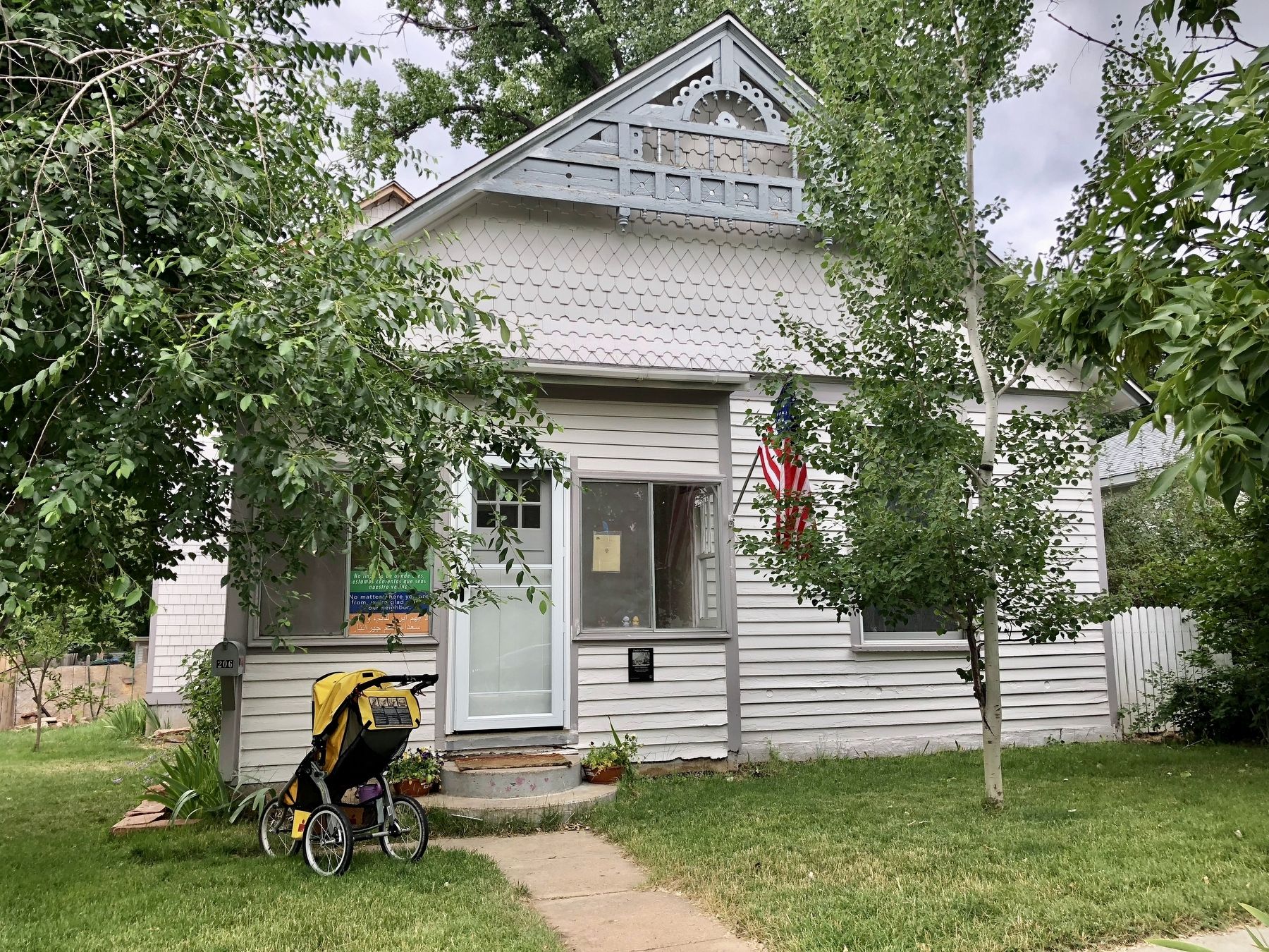
The former Padfield House.
| 101 ► Colorado, Boulder County, Lafayette — 5 — Padfield House — 206 East Simpson Street — Historic Lafayette Walking Tour — |
| On East Simpson Street east of South Harrison Avenue, on the right when traveling east. | |||
| 102 ► Colorado, Boulder County, Lafayette — 32 — Peltier House — 107 South Public Road — Historic Lafayette Walking Tour — |
| On South Public Road south of East Simpson Street, on the right when traveling south. | |||
| 103 ► Colorado, Boulder County, Longmont — Site of Burlington, Colorado Territory — First Town on the St. Vrain, 1860 - 1871. — |
| On Delaware Avenue, 0 miles east of South Coffman Street, on the right when traveling west. | |||
| 104 ► Colorado, Boulder County, Superior — The Denver-Boulder Turnpike — |
| On U.S. 36 north of Colorado Highway 170, on the right when traveling north. | |||
| 105 ► Colorado, Broomfield County, Broomfield — 911 Memorial — |
| Near Spader Way at Community Park Road, on the left when traveling north. | |||
| 106 ► Colorado, Broomfield County, Broomfield — Columbine Mine / Coal Field Country — |
| On East Baseline Road (Colorado Route 7) 0.3 miles east of Mountain View Boulevard, on the right when traveling east. | |||
| 107 ► Colorado, Chaffee County, Buena Vista — Getting from There to Here — |
| On U.S. 24, 1 mile east of County Highway 397, on the left when traveling east. | |||
| 108 ► Colorado, Chaffee County, Buena Vista — Stagecoach Road to Riches — |
| On U.S. 24, 1 mile east of County Highway 397, on the left when traveling east. | |||
| 109 ► Colorado, Chaffee County, Buena Vista — The Placers In Between — |
| On U.S. 24, 1 mile east of County Highway 397, on the left when traveling east. | |||
| 110 ► Colorado, Chaffee County, Nathrop — Peaks to Pastures — Collegiate Peaks Scenic and Historic Byway — |
| On U.S. 285, 2 miles south of Chalk Creek Drive, on the right when traveling south. | |||
| 111 ► Colorado, Chaffee County, Nathrop — Valley Ranching — |
| On U.S. 285, 2 miles south of Chalk Creek Drive, on the right when traveling south. | |||
| 112 ► Colorado, Chaffee County, Nathrop — Whose Water Is It? — |
| On U.S. 285, 2 miles south of Chalk Creek Drive, on the right when traveling south. | |||
| 113 ► Colorado, Chaffee County, Poncha Springs — The Jackson Hotel — |
| On U.S. 285, on the right when traveling north. | |||
| 114 ► Colorado, Chaffee County, Salida — Chaffee County Honor Roll Board — [World War II] — |
| On F Street at 2nd Street, on the right when traveling north on F Street. | |||
| 115 ► Colorado, Chaffee County, Salida — 130 — Christmas 1806 — |
| On U.S. 285, 5 miles north of U.S. 50, on the left when traveling north. | |||
| 116 ► Colorado, Chaffee County, Salida — Finding Our Roots / New Faces Along the River / Pike Explores the Valley — |
| On U.S. 285, on the right when traveling south. | |||
| 117 ► Colorado, Chaffee County, Salida — The Salida Steam Plant — |
| On West Sackett Avenue near G Street. | |||
| 118 ► Colorado, Cheyenne County, Cheyenne Wells — Cheyenne County Jail — Built in 1894 — |
| On West 2nd Street North at North 1st Street West, on the left when traveling north on West 2nd Street North. | |||
| 119 ► Colorado, Cheyenne County, Cheyenne Wells — 207 — Trails West — |
| On U.S. 40 at milepost 463.5, on the left when traveling east. | |||
| 120 ► Colorado, Cheyenne County, Kit Carson — 150 — Kit Carson — |
| On U.S. 287 at milepost 130, on the right when traveling west. | |||
| 121 ► Colorado, Cheyenne County, Kit Carson — Old Cattle Trail — |
| On State Highway 59 south of County Route CC, on the right when traveling south. | |||
| 122 ► Colorado, Cheyenne County, Kit Carson — The Kit Carson Railroad Depot — |
| On Route 287 at milepost 130, on the right when traveling west. | |||
| 123 ► Colorado, Clear Creek County, Georgetown — Commemorating the Historical Importance of the Georgetown Mining Region — |
| On Rose Street, 0.1 miles south of Sixth Street, on the left when traveling south. | |||
| 124 ► Colorado, Clear Creek County, Georgetown — Cornish House, 1892 — Georgetown-Silver Plume National Historic Landmark District — |
| On Argentine Street south of 4th Street, on the left when traveling south. | |||
| 125 ► Colorado, Clear Creek County, Georgetown — Cushman Block I, 1872 — Georgetown-Silver Plume National Historic Landmark District — |
| On Sixth Street at Taos Street, on the right when traveling west on Sixth Street. | |||
| 126 ► Colorado, Clear Creek County, Georgetown — Cushman Block II, 1872/1875 — Georgetown-Silver Plume National Historic Landmark District — |
| On Sixth Street at Taos Street, on the right when traveling west on Sixth Street. | |||
| 127 ► Colorado, Clear Creek County, Georgetown — Fish Block, 1889 — Georgetown-Silver Plume National Historic Landmark District — |
| On Sixth Street at Rose Street, on the right when traveling west on Sixth Street. | |||
| 128 ► Colorado, Clear Creek County, Georgetown — Forbes Building, ca. 1869 — Georgetown-Silver Plume National Historic Landmark District — |
| On Taos Street south of 6th Street, on the right when traveling south. | |||
| 129 ► Colorado, Clear Creek County, Georgetown — Hamill House Museum — |
| On Argentine Street, on the right when traveling south. | |||
| 130 ► Colorado, Clear Creek County, Georgetown — 12 — Hotel de Paris — |
| On Sixth Street at Taos, on the right when traveling east on Sixth Street. | |||
| 131 ► Colorado, Clear Creek County, Georgetown — Hotel de Paris, 1875-90 — Georgetown-Silver Plume National Historic Landmark District — |
| On Sixth Street at Taos Street, on the right when traveling east on Sixth Street. | |||
| 132 ► Colorado, Clear Creek County, Georgetown — John Tomay Memorial Library 1924 — Georgetown-Silver Plume National Historic Landmark District — |
| On Sixth Street at Rose Street, on the right when traveling east on Sixth Street. | |||
| 133 ► Colorado, Clear Creek County, Georgetown — Kneisel and Anderson Store, 1892 — Georgetown-Silver Plume National Historic Landmark District — |
| On Sixth Street at Rose Street, on the right when traveling east on Sixth Street. | |||
| 134 ► Colorado, Clear Creek County, Georgetown — Masonic Temple, 1892 — Georgetown-Silver Plume National Historic Landmark District — |
| On Sixth Street at Rose Street, on the right when traveling west on Sixth Street. | |||
| 135 ► Colorado, Clear Creek County, Georgetown — McClellan Opera House — |
| On Sixth Street at Taos Street, on the right when traveling east on Sixth Street. | |||
| 136 ► Colorado, Clear Creek County, Georgetown — McMurdy-Snetzer Building, 1869 — Georgetown-Silver Plume National Historic Landmark District — |
| On Taos Street at 5th Street, on the right when traveling north on Taos Street. | |||
| 137 ► Colorado, Clear Creek County, Georgetown — Monti and Guanella Building, 1867 — Georgetown-Silver Plume National Historic Landmark District — |
| On Sixth Street at Rose Street, on the right when traveling west on Sixth Street. | |||
| 138 ► Colorado, Clear Creek County, Georgetown — Old County Courthouse, 1868 — Georgetown-Silver Plume National Historic Landmark District — |
| On Sixth Street at Argentine Street, on the right when traveling east on Sixth Street. | |||
| 139 ► Colorado, Clear Creek County, Georgetown — 3 — Old Town Jail — 1883 — Georgetown-Silver Plume National Historic Landmark District — |
| On 5th Street, on the right when traveling south. | |||
| 140 ► Colorado, Clear Creek County, Georgetown — Star Hook and Ladder Building 1886 — Georgetown-Silver Plume National Historic Landmark District — |
| On Sixth Street at Griffith Street, on the left when traveling east on Sixth Street. | |||
| 141 ► Colorado, Clear Creek County, Georgetown — Teal Building, 1875 — Georgetown-Silver Plume National Historic Landmark District — |
| On Rose Street at 4th Street, on the right when traveling south on Rose Street. | |||
| 142 ► Colorado, Clear Creek County, Georgetown — The Story of the Eisenhower-Johnson Memorial Tunnels — We went by the book, but the mountain couldn't read — R.C. (Rube) Hopper, 1972 — |
| Near Argentine Street. | |||
| 143 ► Colorado, Clear Creek County, Georgetown — Tucker Brothers Store, ca. 1870 — Georgetown-Silver Plume National Historic Landmark District — |
| On Sixth Street just west of Taos Street, on the right when traveling east. | |||
| 144 ► Colorado, Clear Creek County, Idaho Springs — Arrastra — |
| On Miner Street just west of 14th Avenue, on the right when traveling west. | |||
| 145 ► Colorado, Clear Creek County, Idaho Springs — Drexel Lacey — |
| 146 ► Colorado, Clear Creek County, Idaho Springs — Idaho Springs Opera House — 1535 Miner Street — |
| On Miner Street, 0.1 miles east of 15th Avenue, on the right when traveling east. | |||
| 147 ► Colorado, Clear Creek County, Idaho Springs — Mining Exchange Building — 1517 - 1523 Miner Street — |
| On Miner Street, 0.1 miles east of 15th Avenue, on the right when traveling east. | |||
| 148 ► Colorado, Clear Creek County, Idaho Springs — The Charlie Tayler Waterwheel — |
| On Interstate 70, 0.2 miles east of Chicago Creek Road. | |||
| 149 ► Colorado, Clear Creek County, Idaho Springs — The Mead and Cooper Building — 1511-1515 Miner Street — |
| On Miner Street just east of 15th Avenue, on the right when traveling east. | |||
| 150 ► Colorado, Clear Creek County, Idaho Springs — University of Denver — Meyer Womble Observatory — |
| Near Mt. Evans Road south of Colorado Highway 103. | |||
| 151 ► Colorado, Clear Creek County, Silver Plume — Argentine Central Railway — |
| On Mountain Street, on the right when traveling west. | |||
| 152 ► Colorado, Conejos County, Antonito — Cumbres Pass — |
| On State Highway 17, 12 miles south of County Road 128, on the left when traveling north. | |||
| 153 ► Colorado, Conejos County, Manassa — "The Manassa Mauler" — |
| On Main Street (State Highway 142) 0.1 miles east of 5th Street, on the right when traveling east. | |||
| 154 ► Colorado, Conejos County, Sanford — 43 — Pike's Stockade — |
| On County Road 24, 0.8 miles south of County Road Y, on the right when traveling east. | |||
| 155 ► Colorado, Costilla County, Fort Garland — Costilla County Veterans Memorial — |
| 156 ► Colorado, Costilla County, Fort Garland — 16 — Fort Garland |
| On State Highway 159, 0.2 miles south of U.S. 160, on the left when traveling north. Reported permanently removed. | |||
| 157 ► Colorado, Costilla County, Fort Garland — 190 — Fort Garland / Buffalo Soldiers — |
| Near State Highway 159, on the right when traveling south. | |||
| 158 ► Colorado, Crowley County, Crowley — Crowley — Biggest Little Town — |
| On Broadway at State Route 96, on the right when traveling north on Broadway. | |||
| 159 ► Colorado, Crowley County, Crowley — Crowley Communities / National Sugar Company / Last Days of the Buffalo / Crowley Country — |
| On Colorado Route 96 at Broadway, on the right when traveling west on State Route 96. | |||
| 160 ► Colorado, Custer County, Greenwood — Cliffhangers and Headbangers — |
| On Colorado 96, 0.4 miles west of County Road 387, on the right when traveling west. | |||
| 161 ► Colorado, Custer County, Greenwood — Frontier Pathways Scenic and Historic Byway — |
| On Colorado 96, 0.4 miles west of County Road 387, on the right when traveling west. | |||
| 162 ► Colorado, Custer County, Westcliffe — Mining and Ranching / Early Settlement / Westcliffe and Silver Cliff / Westcliffe Country — |
| On Colorado Route 69, 0.7 miles south of Verdemont Road (County Road 182), on the right when traveling south. | |||
| 163 ► Colorado, Custer County, Wetmore — Cuerno Verde |
| On Colorado 67 (at milepost 2) at County Road 19C, on the right when traveling south on Colorado 67. Reported unreadable. | |||
| 164 ► Colorado, Custer County, Wetmore — Hardscrabble — |
| On Colorado 67 (at milepost 2) at County Road 19C, on the right when traveling south on Colorado 67. | |||
| 165 ► Colorado, Custer County, Wetmore — Hardscrabble |
| On Colorado 67 (at milepost 2) at County Road 19C, on the right when traveling south on Colorado 67. Reported unreadable. | |||
| 166 ► Colorado, Delta County, Delta — Central School Bell — |
| On 3rd Street east of Main Street (U.S. 50), on the left when traveling east. | |||
| 167 ► Colorado, Delta County, Delta — Delta County Bank Building — 1892 — |
| On Main Street (U.S. 50) at 3rd Street, on the right when traveling south on Main Street. | |||
| 168 ► Colorado, Delta County, Delta — Delta Jail - 1890 — |
| On 3rd Street east of Main Street (U.S. 50), on the left when traveling east. | |||
| 169 ► Colorado, Delta County, Delta — Delta Post Office — 1938 — |
| On Meeker Street at 4th Street, on the right when traveling north on Meeker Street. | |||
| 170 ► Colorado, Delta County, Delta — Delta Public Library — 1911 — |
| On Palmer Street at 6th Street, on the right when traveling south on Palmer Street. | |||
| 171 ► Colorado, Delta County, Delta — Egyptian Theatre — 1928 — |
| On Main Street (U.S. 50) north of 5th Street, on the right when traveling north. | |||
| 172 ► Colorado, Delta County, Delta — First Methodist Episcopal Church of Delta — 1910 — |
| On Meeker Street at 5th Street, on the right when traveling north on Meeker Street. | |||
| 173 ► Colorado, Delta County, Delta — Fort Uncompahgre — |
| Near North Palmer Street north of Confluence Drive, on the right when traveling north. | |||
| 174 ► Colorado, Delta County, Delta — I. Hunter, D.D.S. Building — 1900 — |
| On Main Street (U.S. 50) north of 5th Street, on the left when traveling north. | |||
| 175 ► Colorado, Delta County, Delta — L.A. Hick, M.D. Building — 1900 — |
| On Main Street (U.S. 50) north of 5th Street, on the left when traveling north. | |||
| 176 ► Colorado, Delta County, Delta — Leslie J. Savage Big Bell Collection — |
| On 3rd Street east of Main Street (U.S. 50), on the left when traveling east. | |||
| 177 ► Colorado, Delta County, Delta — Mangum Memorial Wind-Chime — |
| On 3rd Street east of Main Street (U.S. 50), on the left when traveling east. | |||
| 178 ► Colorado, Delta County, Delta — Presbyterian Church of Delta — 1901 — |
| On Meeker Street at 4th Street, on the left when traveling north on Meeker Street. | |||
| 179 ► Colorado, Delta County, Delta — Robert E. Lee Steamboat Bell — |
| On 3rd Street east of Main Street (U.S. 50), on the left when traveling east. | |||
| 180 ► Colorado, Delta County, Delta — Site of Farmers and Merchants Bank — |
| On Main Street (U.S. 50) north of 4th Street, on the right when traveling north. | |||
| 181 ► Colorado, Delta County, Delta — Stockham Building — 1908 — |
| On Main Street (U.S. 50) north of 4th Street, on the right when traveling north. | |||
| 182 ► Colorado, Delta County, Delta — Ute Council Tree — |
| On G96 Lane at 1550 Road, on the left when traveling west on G96 Lane. | |||
| 183 ► Colorado, Delta County, Delta — Western Slope Agriculture / Delta County — |
| On North Palmer Street, 0.1 miles north of Confluence Drive, on the right when traveling north. | |||
| 184 ► Colorado, Delta County, Hotchkiss — West Elk Loop — Scenic and Historic Byway — |
| On County Highway 92 at Doc Maloney Way, on the right when traveling south on County Highway 92. | |||
| 185 ► Colorado, Denver County, Denver, Auraria — Elephant Corral — |
| On Blake Street at 14th Court, on the left when traveling west on Blake Street. | |||
| 186 ► Colorado, Denver County, Denver, Auraria — Site of the First Gathering of Freemasons in Colorado — |
| On Auraria Parkway at 12th Street, on the right when traveling east on Auraria Parkway. | |||
| 187 ► Colorado, Denver County, Denver, Auraria — The Auraria Townsite and Ninth Street Historic Park — |
| On Ninth Street near Curtis Street. | |||
| 188 ► Colorado, Denver County, Denver, Auraria — 32 — The Rocky Mountain News — |
| On Market Street at 14th Street on Market Street. | |||
| 189 ► Colorado, Denver County, Denver, Ballpark District — 18th St. Atrium / Littleton Creamery Beatrice Cold Storage Warehouse — Lower Downtown Walking Tour — |
| On 18th Street at Wynkoop Street, on the right when traveling north on 18th Street. | |||
| 190 ► Colorado, Denver County, Denver, Ballpark District — Blake Street Area — Lower Downtown Historic District — Established 1988 — |
| On Blake Street west of 20th Street, on the right when traveling west. | |||
| 191 ► Colorado, Denver County, Denver, Ballpark District — General Electric Building — |
| On 18th Street south of Blake Street, on the right when traveling north. | |||
| 192 ► Colorado, Denver County, Denver, Ballpark District — Hop Alley/Chinese Riot of 1880 — Lower Downtown Walking Tour |
| On 20th Street at Blake Street, on the right when traveling south on 20th Street. Reported permanently removed. | |||
| 193 ► Colorado, Denver County, Denver, Ballpark District — Local Transit Through the Ages — Look How Far We've Come — 1871-Present — |
| On Wynkoop Street north of 16th Street, on the right when traveling south. | |||
| 194 ► Colorado, Denver County, Denver, Ballpark District — Merchandise Mart — 1930 — Lower Downtown Walking Tour — |
| On Wazee Street at 19th Street, on the right when traveling north on Wazee Street. | |||
| 195 ► Colorado, Denver County, Denver, Ballpark District — Red Light District Market Street — 1890 - 1912 — Lower Downtown Walking Tour — |
| On Market Street at 20th Street, on the right when traveling south on Market Street. | |||
| 196 ► Colorado, Denver County, Denver, Ballpark District — The House of Mirrors — 1942 Market Street — |
| On Market Street south of 20th Street. | |||
| 197 ► Colorado, Denver County, Denver, Ballpark District — The People of the Station — and the Stories they Tell — Voices from the Past — |
| On Wynkoop Street at 17th Street, on the right when traveling south on Wynkoop Street. | |||
| 198 ► Colorado, Denver County, Denver, Ballpark District — The Reverend Yoshitaka Tamai — Born October 10, 1900 - Died September 25, 1983. — |
| On 19th Street at Larimer Street, on the right when traveling west on 19th Street. | |||
| 199 ► Colorado, Denver County, Denver, Ballpark District — Union Station — 1880 / 1914 — Lower Downtown Walking Tour — |
| On Wynkoop Street near 17th Street. | |||
| 200 ► Colorado, Denver County, Denver, Ballpark District — Union Station Area — Lower Downtown Historic District — Established 1988 — |
| On Wynkoop St near 17th Street. | |||
1604 entries matched your criteria. Entries 101 through 200 are listed above. ⊲ Previous 100 — Next 100 ⊳