Near Sha’ul HaMelech Street (Northern District Route 6667) just west of National Route 90, on the right when traveling west.
English Text:
The summer months pulsate with heat in the Bet-She'an Valley. At its heart, in the ancient city of Bet-She'an, were discovered the remains of bathhouses, fountains, and ornamental pools - echoes of a past rich in water . . . — — Map (db m141501) HM
Near Sha’ul HaMelech Street (Northern District Route 6667) just west of Route 90, on the right when traveling west.
English Text:
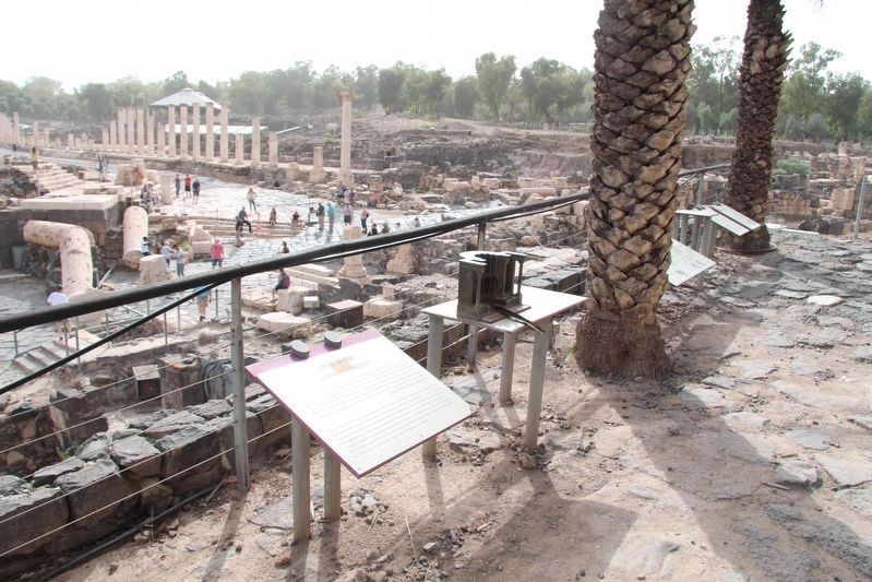
Monument
The purpose of this lavish structure is uncertain; it may have served as a central monument. Together with the surrounding buildings, it collapsed in the earthquake of 749 C.E.
Nymphaeum
Splendid . . . — — Map (db m141528) HM
Near Sha’ul HaMelech Street (Northern District Route 6667) just west of National Route 90, on the right when traveling west.
English Text:
Roman Bet-She'an, known as Nyssa Scythopolis, became Christian, reaching its golden age in the 6th century C.E. In the 7th century, Muslims settled in the city, once again changing its character. One day in the year 749, an . . . — — Map (db m141502) HM
Near Sha’ul HaMelech Street (Northern District Route 6667) just west of National Route 90, on the right when traveling west.
English Text:
In the Roman period, during the 2nd century C.E., the monumental center of Bet-She'an was built into the valley at the foot of the tell. Roman style and workmanship were applied in constructing public buildings, which were . . . — — Map (db m141513) HM
Near Northern District Route 90 just east of Northern District Route 807, on the right when traveling north.
English Text:
The Magdala stone: A three-dimensional model of the Temple on which the holy scrolls were placed, was found inside the synagogue.
Four miqva'ot: Purification baths fed by underground water sources are unique compared . . . — — Map (db m140979) HM
Near Northern District Route 90 just east of Northern District Route 807, on the right when traveling north.
The architecture of this area allows us to distinguish two streets that separate three structures following the same symmetric layout as the rooms located west. They are constructed from local materials: the walls are made of roughly hewn basalt . . . — — Map (db m140515) HM
Near Northern District Route 90 just east of Northern District Route 807, on the right when traveling north.
English Text:
c. 200 BC
Magdala is established, likely through Hasmonean influence (Jewish families), during the Hellenistic period.
c. 20-60 AD
Magdala develops from a small village into a prosperous city known for fish . . . — — Map (db m140983) HM
Near Northern District Route 90 just east of Northern District Route 807, on the right when traveling north.
English Text:
c. 1500 AD
Between the earthquake of 363 and the crusader period, the southern part of Magdala witnesses a progressive decrease and multiple variations. It eventually becomes a small Arab village during Mamluk and . . . — — Map (db m141302) HM
Near Northern District Route 90 just east of Northern District Route 807, on the right when traveling north.
The building has peculiar architectural elements, and the existence of groundwater was key for locating the miqwa'ot. The analysis of the architectural plan and the building system suggests that this ritual space on the outside had similar . . . — — Map (db m140867) HM
Near Northern District Route 90 just east of Northern District Route 807, on the right when traveling north.
The Jewish communities of Israel in the Second Temple period used unique water installations called miqwa'ot, which enabled them to maintain ritual purity. According to the Halakhah (Jewish law), religious people should immerse into . . . — — Map (db m140973) HM
On Northern District Route 90, 0.05 kilometers east of Northern District Route 807, on the right when traveling north. Reported missing.
The main axis of this complex is a north-south street that divides two buildings. There are two types of contexts here: housing units in the southern area are constructed simply with blocks of basalt stone and limestone walls. To the east ands west . . . — — Map (db m220391) HM
Near Northern District Route 90 just east of Route 807, on the right when traveling north. Reported missing.
This ritual space stands out due to its mosaic floor that is made of thousands of colored tesserae. A white background, framed by a black meander pattern surrounded by an orange rectangle, emphasizes the image of a rosette in the central panel, . . . — — Map (db m220392) HM
Near Northern District Route 90 just east of Northern District Route 807, on the right when traveling north.
English Texts:
Magdala was the hometown of Mary Magdalene - one of Jesus' most faithful followers.
Luke 4:15, Matthew 4:23; 9:35; Mark 1:39 "Jesus went throughout all Galilee, teaching in their synagogues and proclaiming the good . . . — — Map (db m140982) HM
Near Northern District Route 90 just east of Northern District Route 807, on the right when traveling north.
The architectural features of this area denote a public building identified with commercial activities. A North - South street leads to the synagogue and provides the only access to spaces with an additional eastern access to another structures. . . . — — Map (db m141363) HM
Near Al-Bishara Street just north of Paulus ha-Shishi Street, on the right when traveling north.
The stones exhumed form the fill beneath the mosaic floors of the Byzantine building (IV-V century) can be classified: (1) bases, more or less preserved, often having traces of plaster; (2) imposts of a double-arch with a beautifully worked cornice; . . . — — Map (db m139218) HM
Near Paulus Ha Shishi, 0.3 kilometers north of Iksal.
“And the Word became flesh”
Historians tell that the Grotto and its surroundings, being the site of the Annunciation were turned into a worship place in the 1st and 2nd Century.
-Early sources referred to the place as being . . . — — Map (db m44298) HM
Near Al-Bishara Street just north of Paulus ha-Shishi Street, on the right when traveling north.
The most important mosaic floors are found inside the Basilica in the area in front of the Holy Grotto. Those shown here come from the monastery on the south side of the Byzantine Church. They had the value of "sealed levels" having preserved some . . . — — Map (db m139256) HM
Near National Route 60 just south of National Route 75, on the right when traveling south.
Rising above the southern part of the
Nazareth Mountain Mt. of Precipice (397 meters)
Look out over Nazareth, Mt. Tabor and
The Yizrael Valley at its foot.
Mt. of Precipice is also known as "The
Leaping Mountain" - according to old . . . — — Map (db m65395) HM
Near Al-Bishara Street, 0.3 kilometers north of Paulus ha-Shishi Street, on the right when traveling north.
What is left of the ancient village consist of a network of grottoes and bits of walls form various historical periods. Going backwards in time we found first the remains of the XVII century Franciscan monastery, then the palace of the crusader . . . — — Map (db m65462) HM
Near Paulus Ha Shishi, 0.4 kilometers north of Iksal.
[Text in Hebrew …]
[Text in Arabic…]
This church was built in 1914 on the site of an earlier 12th century church.
-The caves, granaries and wells in the lower level were used by the early dwellers of Nazareth. Later, . . . — — Map (db m44353) HM
On HaBanim (National Route 90) just north of HaGalil, on the right when traveling north.
Tiberias the capital of the Galilee, one of the four Holy Cities of Israel Which was built by Antipas in the year 17-20, C.E. Antipas named the city Tiberias in honor of the Roman Ceasar, Tiberius. The institution of Jewish Leadership, the Sanhedrin . . . — — Map (db m65327) HM
Near HaBanim (National Route 90) just north of HaGalil, on the right when traveling north.
This building was part of Tiberias' northern quarter between the 6th and 11th centuries CE. The quarter occupied by Jews and the synagogue stood in its center. This building has three rooms and a courtyard with a well. — — Map (db m65359) HM
On HaBanim (National Route 90) close to HaGalil, on the right when traveling north.
Doors of Burial Caves
Burial caves were frequently sealed by stone doors in order to prevent bad smells and looting. In 2nd-3rd centuries CE Tiberias, basalt doors were used in mausolea and decorated with relief of panels and iron nails that . . . — — Map (db m65341) HM
Near HaBanim (National Route 90) just north of HaGalil, on the right when traveling north.
The Architecture of Tiberias
The columns, bases, cornices and capitals attest to the superb architecture of the public buildings in Tiberias. These were built according to the 2nd-3rd centuries CE Roman Imperial tradition. The . . . — — Map (db m65352) HM
Near HaBanim (National Route 90) just north of HaGalil, on the right when traveling north.
[Text at the top of the marker]: The Crusader-Ottoman Building
This was built in the 12th century CE and remained in use until the Ottoman period. The hall has typical pointed vaults and embrasures in the walls, with remains of . . . — — Map (db m65331) HM
On HaBanim (National Route 90) close to HaGalil, on the right when traveling north.
The wall was erected by the Beduin Governor of the Tiberias Region, Daher El-Omer, in the 18th century on the basis of the ruins of an earlier wall built by the Crusaders.
The wall was destroyed in the 1837 earthquake and since then only . . . — — Map (db m65326) HM
Near HaBanim (National Route 90) just north of HaGalil, on the right when traveling north.
This is one of the thirteen synagogues existed in Tiberias according to the Talmud. It was a square building divided by two rows of columns. One of the mosaics bears a dedication inscription decorated with Jewish symbols: Lulav and Etrog. The . . . — — Map (db m65333) HM
Near National Route 7926 just north of National Route 79, on the right when traveling north.
The Citadel (perhaps a watch tower) was built during the crusader period on foundations from an earlier period. Some of the cornerstones are rubble-filled Roman sarcophagi.
In the 18th Century the building was renovated by Dahr El-Omar, the . . . — — Map (db m65412) HM
Near National Route 7926 just north of National Route 79, on the right when traveling north.
The Roman theater was built in the late first or early second century C.E. Carved into the bedrock on the steep northern slope of the hill. It's diameter is 72 m., and it seated 4000.
The rows of seats constructed on the hewn bedrock were robbed . . . — — Map (db m65405) HM
Near Northern District Route 888 just north of Northern District Route 87, on the left when traveling north.
English Text:
This spacious palace faced a paved
courtyard that led to the city gate.
Its wide entrance opened into a vestibule
and it had a throne hall surrounded by
eight service chambers.
This palace is of Neo-Hittite . . . — — Map (db m139345) HM
Near Northern District Route 888 just north of Northern District Route 87, on the left when traveling north.
English Text:
This is the ancient road leading to the city gate. The road was paved during the 10th century B.C.E. and was in use until the 3rd century C.E. It was paved on a series of terraces seen in the slope. Farther ahead the road . . . — — Map (db m139308) HM
Near Northern District Route 888 north of Northern District Route 87, on the left when traveling north.
English Text:
The inner city gate includes
four chambers, two on each side.
In this chamber vessels
for offerings at the high places were kept.
The other three chambers served as granaries.
The city gate was destroyed by the . . . — — Map (db m139336) HM
Near Northern District Route 888 just north of Northern District Route 87, on the left when traveling north.
English Text:
The outer city gate was part of the heavy
fortification that protected the city.
It included an inner city gate and four solid towers.
Between the two gates was a spacious paved courtyard.
The gate of Bethsaida . . . — — Map (db m139317) HM
On Route 888 just north of Northern District Route 87, on the left when traveling north.
English Text:
The inhabitants of the kingdom of Geshur were
Aramaens and the high places and ritual
objects reflect their religion.
On the sacrificial high place were found
fragments of basins, horned altars, and an
incised . . . — — Map (db m139343) HM
Near Route 888 just north of Route 87, on the left when traveling north.
Whenever he went, to village or town or farm,
they laid the sick in the streets and begged him
to let them simply touch the edge of his cloak;
and all who touched him were healed.
Mark 6:56 — — Map (db m139383) HM
Near Northern District Route 888 north of Northern District Route 87, on the left when traveling north.
Jesus was walking by the Sea of Galilee when
he saw Simon and his brother Andrew
at work with casting-nets in the lake;
for they were fishermen. Jesus said to them,
'Come follow me, and I will make you fishers of men.'
At once they left . . . — — Map (db m139366) HM
Near Route 888 just north of Route 87, on the left when traveling north.
English Text:
Wine is like life to men, if you drink it
in moderation. What is life to a man who
is without wine?
It has been created to make men glad.
Sirach 31:27 — — Map (db m139374) HM
Near Northern District Route 92, 0.08 kilometers south of Northern District Route 789, on the left when traveling south.
English Text:
In the time of the most God - beloved Stephanos the priest and abbot was made the mosaic of the Photisterion in the month of December fourth indiction in the time of the pious and Christ - beloved our King Mauricius . . . — — Map (db m139423) HM
Near Northern District Route 92 at Route 789 when traveling south.
Kursi, east of the Sea of Galilee, is identified with Gergessa, or with "the Land of the Gardarenes," of the New testament, where the miracle of the swine took place. (Luke 8:26-39)
There were three main periods of settlement at Kursi: . . . — — Map (db m139392) HM
Near Northern District Route 888 north of Northern District Route 87, on the left when traveling north.
English Text:
This is the heart of the ancient town.
Here the public activities of the city took
place. It was the center of commercial,
juridicial, and religious life.
"Now David was sitting between the two gates,
and . . . — — Map (db m139327) HM
According to the Gospel of John, scripture indicates that Jesus was baptized very close to this part of the “Jordan River”. Of the four Gospel writers, John was the only one present when Jesus was baptised by John the Baptist.
In . . . — — Map (db m44228) HM
Capharnaum the town of Jesus
He left Nazareth and went to live in Capharnaum by the sea (Gospel of Matthew 4:13). He entered a boat, made a crossing, and came into his own town (Gospel of Matthew 9:1).
The House of Simon Peter
On . . . — — Map (db m44108) HM
The synagogue is made up of four units, namely the prayer hall, the eastern courtyard, the southern porch, and a side-room near the northwestern corner of the prayer hall.
The prayer hall, with the façade toward Jerusalem, is rectangular in . . . — — Map (db m44055) HM
History
28–350 AD
The Judeo-Christians of Capharnaum venerated a large rock upon which Jesus is said to have laid the bread and fish before he fed the five thousand (Mk 6:30-44)
ca. 350 AD
Used as an altar, the rock . . . — — Map (db m44034) HM
Capharnaum is located on the northwest shore of the Sea of Galilee, 16 kilometers northeast of modern Tiberias, 3 kilometers northeast of ancient Heptapegon (modern Tabgha), and 5 kilometers southwest of the upper Jordan River. The original Semitic . . . — — Map (db m221192) HM
• (Blue icon)-1905 First excavations in the 5th c. Synagogue by Heinrich Kohl and Carl Watzinger of the Deutsche Orient- Gesellschaft, on behalf of the Custody of the Holy Land.
• (Green icon)-1915 First excavations in the old village, as . . . — — Map (db m221198) HM
The Sea of Galilee (named after the surrounding area, the Galil) is where several pivotal events in the earthly life of Jesus took place, including:
•Fishermen Simon (Peter) and his brother Andrew were called by Jesus on these shores; they . . . — — Map (db m221195) HM
THE FIFTH CENTURY OCTAGONAL CHURCH
In the second half of the fifth century an octagonal church was erected on a raised level within the perimeter of the previous enclosure wall. The plan consisted of a small central octagon, of a larger . . . — — Map (db m222077) HM
THE Eight Pillars
•1 The Crucifixion
•2 Jesus teaches "become like this little child" to enter the Kingdom of Heaven
•3 Jesus heals the paralytic man lowered through the roof of St. Peter's House Et Ferentes Paralyticum...Nudaverunt . . . — — Map (db m221184) HM
This is a rectangular building where spaces are arranged around a courtyard that allows communication, lighting and ventilation into the rooms. It has two clear entrances: one that leads to the courtyard without interfering with domestic activities . . . — — Map (db m220401) HM
In this area, some walls and materials were found below the level of the first century period, which were dated to the Hellenistic period. Thus, we may infer that the first settlement of the town was between 332-63 BCE.
Due to the distribution . . . — — Map (db m220402) HM
This synagogue is dated to the first century CE, before the destruction of the Second Temple. It is the first synagogue discovered in Galilee and one of seven known from this period in the Land of Israel. The impressive structure was established by . . . — — Map (db m220390) HM
In blessed memory of John Paul II
pilgrim to Tabgha on March 24, 2000
this bronze door was blessed
by Cardinal Stanisław Dziwisz
Metropolitan Archbishop of Krakow,
November 16, 2006 — — Map (db m221201) HM
On HaAtsmaut Street, on the left when traveling south.
LIBERATION OF TIBERIAS MEMORIAL
At the end of March 1948, the Arabs of Tiberias succeeded, with the assistance of armed gangs from the outside, to cut off the Jewish Quarter in the old city from the new one. At the same time, they cut off the . . . — — Map (db m222079) HM WM
Rabbi Ammi was among the greatest Talmudic sages and scholars of the third generation (of rabbis) in the Land of Israel (beginning of the 4th c. CE). Rabbi Ammi was head of the Yeshiva in Tiberias following the death of his rabbi, Rabbi Yochanan. . . . — — Map (db m221220) HM
The son of Avraham, son of the Rambam, David served as Nagid (head) of the Jewish community in Egypt, Syria and the Land of Israel in the 13th century CE. When rabbis demanded that the Rambam's "Guide for the Perplexed" be banned, he fought for his . . . — — Map (db m221396) HM
Rabbi Eliezer ben Hyrkanos was among Rabban Yochanan ben Zakkai's most prominent pupils. He was raised in a wealthy home but gave up a life of abundance, choosing to dedicate himself to Torah learning. His rabbi said that he was like a "cemented pit . . . — — Map (db m221218) HM
Rabbi Maimon ben Yosef was a student of Rabbi Yosef Halevi Ibn Magash and lived in the 12th century CE. Escaping anti-Semitic rioters, Rabbi Maimon took his family on a long and difficult road to safety from Cordoba in Spain to Morocco and from . . . — — Map (db m221400) HM
Rabbi Yochanan ben Zakkai was one of the students of Hillel and Shammai. He escaped the besieged city of Jerusalem immediately before its destruction (in the year 70 CE) and asked Vespasian, the commander of Roman forces in Judea, to "Give me Yavneh . . . — — Map (db m221206) HM
On Ha-Banim Street, on the left when traveling north.
This portion of the Old City wall was preserved intact. It is the remains of the wall built during the 18th century by the Beduin Ruler of the region Daher El-Omar. It is easy to notice the shooting posts on the wall.
On the west side, in . . . — — Map (db m221402) HM
Rabbi Yeshayahu Halevi Horwitz, the "Shlah", a rabbi and kabbalist, one of the greatest Ashkenazi (Western European) scholars, lived in the 15th century. He held religious positions in various Jewish communities across Europe, the main one being in . . . — — Map (db m221223) HM
The Rambam, "The Great Eagle", was among the greatest of Jewish sages of the Middle Ages and a symbol of Jewish wisdom. He was born in the year 4898 (1138) in Cordoba, Andalusia to the judge Rabbi Maimon and his wife. He was forced to wander with . . . — — Map (db m221398) HM
The synagogue was discovered in 1905 by H. Kohl and C. Waltzinger.
It is a square building belonging to the Galilean type of synagogue with a number of special components:
• The main entrance in the eastern wall.
• The niche for holy ark in . . . — — Map (db m126103) HM
Qarne Hittin is the crater of an ancient volcano that was active 4.3 million years ago. On the north and the south sides of the crater are the mountain's two "horns", which gave rise to the Hebrew name Qarne Hittin meaning "horns of wheat."
On . . . — — Map (db m137054) HM
Near Northern District Route 87, 16.7 kilometers east of Northern District Route 90, on the right when traveling east.
Capharnaum is located on the northwest shore of the Sea of Galilee, 16 kilometers northeast of modern Tiberias, 3 kilometers northeast of ancient Heptapegon (modern Tabgha), and 5 kilometers southwest of the upper Jordan River. The original Semitic . . . — — Map (db m139434) HM
Near Northern District Route 8277, 2.5 kilometers east of Northern District Route 90, on the right when traveling east.
English Text:
"Corazin, a village in the Galilee, cursed by the Messiah, lies in ruins today."
[Eusebius, a 4th century church patriarch]
Jesus and his disciples preached and taught along the shores of Lake . . . — — Map (db m140122) HM
Near Northern District Route 8277, 2.5 kilometers east of Northern District Route 90, on the right when traveling east.
English Text:
Chorazin's synagogue was built of hard, dark basalt stones, difficult to carve and engrave.
Despite this, the builders and artists managed to carve hundreds of ornamental designs and architectural elements, geometric . . . — — Map (db m140113) HM
Near Northern District Route 8277, 2.5 kilometers east of Northern District Route 90, on the right when traveling east.
English Text:
In Greek mythology, Medusa was one of the three Gorgons. Whoever dared to look her in the face was instantly turned to stone. Perseus (averting his eyes) succeeded in killing her and the winged horse Pegasus was born from . . . — — Map (db m140103) HM
Near Northern District Route 8277, 2.5 kilometers east of Northern District Route 90, on the right when traveling east.
English Text:
"Seat (Cathedra) of Moses"
One of the important finds in the Chorazin synagogue is a decorated basalt chair with an Aramaic inscription which mentions Yudan, son of Yishmael, who donated of his wealth to the building of . . . — — Map (db m140472) HM
Near Northern District Route 8277, 2.5 kilometers east of Northern District Route 90, on the right when traveling east.
English text:
Chorazin's ancient synagogue was first excavated in 1905-1907 by a German expedition headed by H. Kohl and C. Watzinger, and in the 1920s and in 1939 by the Mandatory Department of Antiquities and the Hebrew University of . . . — — Map (db m140488) HM
On Israel National Trail, on the right when traveling west.
Welcome!
Cool springs, originating in snow on Mt. Hermon, emerge in the reserve and create the Dan Stream, the largest and most important source of the Jordan River. Salamanders and rare invertebrates live in the chilly water, canopied by a "moist . . . — — Map (db m221406) HM
Welcome!
Cool springs, originating in snow on Mt. Hermon, emerge in the reserve and create the Dan Stream, the largest and most important source of the Jordan River. Salamanders and rare invertebrates live in the chilly water, canopied by a "moist . . . — — Map (db m221409) HM
The Dan Springs
Each year springs emerge in the reserve that originate in the cold water of Mount Hermon snowmelt. The Dan Spring, which is considered the largest karstic spring in the Middle East, begins at the Dan Stream, the largest and . . . — — Map (db m221502) HM
Near Rosh Pina - Metulla Road just east of Northern District Route 90, on the left when traveling east.
English Text:
Dated to the 10th century BCE, this gate has six chambers and two towers. Similar gates have been uncovered at Megiddo and Gezer. A summary of King Solomon's activities indeed indicates that the king built Hazor, Megiddo . . . — — Map (db m141365) HM
Near Rosh Pina - Metulla Road just east of Northern District Route 90, on the left when traveling east.
English Text:
The southern temple was in use from the Middle Bronze Age until the Late Bronze Age (17th-14th centuries BCE). The temple was originally a prominent structure, with wide, well-constructed walls, and its three strata of . . . — — Map (db m141372) HM
Near Rosh Pina - Metulla Road just east of Northern District Route 90, on the left when traveling east.
English Text:
Israelite Hazor, from the 10th century BCE (the time of the United Monarchy), included only the upper city. The area of the Israelite city extended over some 35 dunams, and its inhabitants numbered between 1,000 and 1,500. . . . — — Map (db m141415) HM
Near Rosh Pina - Metulla Road just east of Northern District Route 90, on the left when traveling east.
English Text:
This palace, which served the kings of Hazor during the 14th-13th centuries BCE, is of a ceremonial nature (The administrative palace is to be sought elsewhere on the site). The plan, consisting of a courtyard and a throne . . . — — Map (db m141407) HM
Near Rosh Pina - Metulla Road just east of Northern District Route 90, on the left when traveling east.
English Text:
The story of Hazor is represented by 21 layers of settlement. The history of Hazor can be divided into two chapters: Canaanite Hazor and Israelite Hazor.
Canaanite Hazor
You are now in the upper city and . . . — — Map (db m141417) HM
Near Rosh Pina - Metulla Road just east of Northern District Route 90, on the left when traveling east.
English Text:
The biblical tels of Hazor, Megiddo, and Beer Sheba were inscribed in 2005 by the United Nations Educational, Scientific and Cultural Organization (UNESCO) as World Heritage Sites with outstanding universal value. They are . . . — — Map (db m141414) HM
Near Rosh Pina - Metulla Road just east of Northern District Route 90, on the left when traveling east.
English Text:
Constructed during the reign of King Ahab (the 9th century BCE), it was designed to supply the inhabitants of the city with water in times of siege. A vertical shaft was dug through the earlier occupation layers, at the . . . — — Map (db m141421) HM
Near Israel National Trail just north of Northern District Route 99, on the right when traveling north.
English Text:
The entrance gate to Dan from the time of the Israelite Kingdom.
– Gate chamber
– Canopied structure for a king or a judge
– Paved, outer piazza for chariots
English Text on Marker . . . — — Map (db m141428) HM
Near Israel National Trail just north of Northern District Route 99, on the right when traveling north.
English Text:
And when Abram heard that his brother was taken captive, he led forth his trained men, born in his house, three hundred and eighteen, and pursued them as far as Dan.
Genesis 14:14
Exterior entry . . . — — Map (db m141448) HM
Near Israel National Trail just north of Northern District Route 99, on the right when traveling north.
English text:
This gate which was approached on a stepped path, is built of three arches. The arches, the piers supporting them, and the towers flanking the gate are constructed of sun-baked bricks and were covered with white plaster. . . . — — Map (db m141441) HM
Near National Route 99 just east of Route 999, on the left when traveling north.
English Text:
Nemesis was the goddess of vengeance and Roman imperial justice. Her long and narrow court was built in 178 CE in front of a great niche in which her statue was placed. A Greek inscription above the niche mentions the names . . . — — Map (db m64781) HM
Near National Route 99 just east of Farm to Market Road 999, on the left when traveling north.
English Text:
The stepped and paved courtyard on which you are standing was built in the mid-first century CE. An artificial cave was quarried in the cliff-face opposite the courtyard, and there the statue of Pan was placed. Pagan . . . — — Map (db m64754) HM
Near National Route 99 just east of Local Route 999, on the left when traveling north.
English Text:
The cave is the nucleus beside which the sacred sanctuary was built. In this "abode of the shepherd god," pagan cult began as early as the 3rd century BCE. The ritual sacrifices were cast into a natural abyss reaching the . . . — — Map (db m64738) HM
Near National Route 99 just east of Local Route 999, on the left when traveling north.
English Text:
The conquests of Alexander the Great (3rd c. BCE) brought the Greeks to the East, and to Banyas. The Greeks were taken by the natural beauty of the site, touched particularly by the cave in which the springs welled. It is . . . — — Map (db m64764) HM
Near National Route 99 just east of Local Route 999, on the left when traveling north.
English Text:
Built in 19 BCE, during the reign of Herod the Great, in honor of the Roman Emperor Augustus. The coin at the top of this text, shows the facade of the temple. In front of you is the western wall of the hall with semicircular . . . — — Map (db m65177) HM
Near National Route 99 just east of Local Route 999, on the left when traveling north.
English Text:
This structure was built around 220 CE. Only parts of this temple survived. Among them are the north wall, part of a semicircular hall (apse), and a semicircular niche behind it. This same structure is depicted on the . . . — — Map (db m141468) HM
Near National Route 99 just east of Route 999, on the left when traveling north.
English Text:
Built around 96 CE in the days of Emperor Trajan, for the city's 100th anniversary. A marble inscription found at the site implies that it was a temple for Pan and for Zeus of Heliopolis (the city of Ba'albek). Only the . . . — — Map (db m64768) HM
Near National Route 99 just east of Local Route 999, on the left when traveling north.
English Text:
This building was erected around 220 CE, in the days of Emperor Elagabalos. The bones of goats that took part in the rituals were buried in the rectangular niches in the main hall, together with offerings of pottery, glass . . . — — Map (db m141458) HM
Visitors to the bathhouse and the theater enjoyed a life of social grace and culture.
But what did they do when nature called?
Like a true Roman-Byzantine city, Bet-She'an had public latrines. Users entered an open courtyard paved with a mosaic . . . — — Map (db m221169) HM
•First settlement-5000-3600 B.C.E.-Challcolithic
•15 to 12 cent. B.C.E., Center of Egyptian rule-3600-1130 B.C.E.-Canaanite
•Death of Saul and his sons at Mt. Gilboa, the corpses were displayed at the city walls-1140-1000 B.C.E.-The Judges . . . — — Map (db m221182) HM
111 entries matched your criteria. The first 100 are listed above. The final 11 ⊳