In loving memory and appreciation for the men and women of Adams County who served our nation.
This monument is dedicated to those veterans who made the supreme sacrifice and gave their todays for our tomorrows
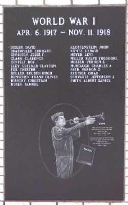
World War I
Apr. 6, 1917 - . . . — — Map (db m37026) HM
The bear has long served as a symbol of Berne, Indiana. Founding fathers named this community after Bern, Switzerland, the area in "the old country" from which the town's settlers had emigrated in 1852. These settlers would have been accustomed to . . . — — Map (db m227614) HM
Settled 1852 by seventy devout Mennonite immigrants who came direct from Switzerland. Town platted 1871, named for capital of Switzerland. — — Map (db m227586) HM
This monument is dedicated to the early settlers of Berne, Indiana, eighty-two devout Mennonite immigrants who came from the Bernese Jura of Switzerland. The first generations cleared the land and drained the swamps, building a future for those of . . . — — Map (db m227612) HM
Honoring
the men and women
of Adams County
who served in
the Armed Forces of
The United States
World War I ——— World War II
Korean ————— Vietnam
and all other . . . — — Map (db m54629) WM
1967
Carey Wellenberger •
1967
William E. Allison •
1969
Boyce D. Phillips •
1968
Stephen E Breiner •
1969
Duane Glandis •
1969
Merlin C Beer
From the years 1965 to 1975 there were 58,000 Americans who lost their lives. Out . . . — — Map (db m211669) WM
2021 People's Choice Award "The inspiration for this sculpture was provided by all the stray neighborhood cats that would visit at night. This is a representation of how they react upon seeing us…"
Artist: Greg Summers
Fremont, Indiana
in . . . — — Map (db m211677) HM
This
Charles A. Dugan Mansion
Circa 1902
has been listed in the
National Register
of Historic Places
by the
United States
Department of the Interior. — — Map (db m211618) HM
Chartered: June 8, 1917
Charter Members
Avon Burk, President •
J. O. Sellemeyer, Vice President •
Arthur Suttles, Second Vice President •
Oscar Hoffman, Secretary •
Arthur Holthouse, Treasurer •
Ashbaurcher, A. R. •
Bell, C. . . . — — Map (db m211674) HM
Decatur was selected as a County Seat on May 18, 1836. The founders were Samuel Rugg and Thomas Johnson. Decatur was surveyed by Jacob Hofer. The land for the site was owned by Thomas Johnson. Decatur was selected by a special county board comprised . . . — — Map (db m211666) HM
"For Which It Stands was commissioned by the Mayor of Itasca, Illinois to be placed in front of the flag pole outside the City Hall. I had an idea for two children to be pledging the flag. When I photographed the children, Eric, who was three, . . . — — Map (db m211691) HM
In Memory of
Gene Stratton - Porter
Author
of
The Girl of The Limberlost,
The Song of the Cardinal, Freckles
and other nature stories.
Who came to Decatur as a bride and in
this County, at Geneva, on the banks of the . . . — — Map (db m54643) HM
This Train Station
Circa 1902
has been listed in the
National Register
of Historic Places
by the
United States
Department of the Interior. — — Map (db m211617) HM
Maybe it was foretold that Pennsylvanian born John Lingenfelter would become one of racing's most legendary engine builders. The gifted son of a mechanic, John began working on cars almost as soon as he could hold a wrench. A move to Indiana to . . . — — Map (db m168283) HM
"Last one in is a rotten egg' is a phrase we often shouted in the summertime. Particularly when racing for the rope while swimming."
Artist: James Haire
Fort Collins, Colorado — — Map (db m211675) HM
"I was commissioned by the Village of Elk Grove, Illinois to create a memorial for four soldiers killed in the Afghan-Iraq war. They wanted a memorial that was more about family and honor, hence the children and lack of weapons. The soldier wears . . . — — Map (db m211690) WM
James Haire, a Colorado Artist, was commissioned to create this life-sized bronze sculpture in honor of the Scouts and Leaders of Adams County. The piece depicts not only the practical skills instruction adult volunteers provide to young scouts . . . — — Map (db m211619) HM
From 1886-1888 Gene Stratton-Porter and her husband Charles Porter lived in a two story woodframe house at this location. Not long after the birth of their only child, Jeanette, the Porters moved to Geneva. — — Map (db m211678) HM
"First card in a traditional Tarot deck, The Magician represents the ancient mystical principle "As Above, So Below." This sculptural "card" portrays The Magician's looping figure-eight infinity symbol with kinetic flipping heads, representing . . . — — Map (db m211693) HM
The first county jail was built in the Southwest Corner of the Courthouse Square and was used until 1868. It was built of double hewn logs: two rooms up, two below at a cost of $325.00. The court house could wait, but the jail had to be built. The . . . — — Map (db m211620) HM
The first election was held in 1833 at the Jeremiah Roe home. Samuel Rugg was appointed Justice of the Peace, David McKnight was appointed first Sheriff. The first County Election was held June 23, 1836.
The officials were: . . . — — Map (db m211668) HM
General Anthony Wayne and the Legion of the United States passed this way on October 30, 1794, in route from Fort Wayne to Fort Greenville, ending the western campaign against the Indian Confederacy. The Legion spent the previous night camped 2.6 . . . — — Map (db m29620) HM
In Memoriam
U.S.S. Maine
Destroyed in Havana Harbor
February 15th 1898
This tablet is cast from metal recovered from the U.S.S. Maine — — Map (db m211664) HM WM
Adams County formed 1835. Geneva incorporation 1874 included early towns Alexander and Buffalo. During 1890s oil boom, population and businesses grew. Fire destroyed much of town 1895; Geneva Board of Trustees banned wooden buildings, mandated . . . — — Map (db m63824) HM
In Southern Adams County as the pioneers came into the new country, the necessity of school was realized. The McHugh school was built near this site in 1837 or 1838 and is reputed to be the first public school in Adams County along with the Gorsline . . . — — Map (db m227615) HM
Platted 1866 by Benjamin Meiser, John L. Peabody and Patrick Ney at the crossroads adjacent to the Peabody Steam Sawmill (1853) and the Fort Wayne, and Chicago Railroad (1855). The post office name was changed from Taw-Taw to Arcola in 1858. — — Map (db m226585) HM
In 2012, God laid a vision on the hearts of the County Line leadership to continue restoring our communities with Christ by expanding the facilities on this site.
The project would cost $5 million, far beyond anything the church had ever done. . . . — — Map (db m211298) HM
Dedicated to the memory of the following Revolutionary Soldiers buried in Allen County
Michael Cronts ·
James Ball ·
Charles Weeks, Sr. ·
William Berry ·
Samuel Bird, Sgt. · James Saunders · Gurdin Burnham, Sgt. · David . . . — — Map (db m73263) WM
Allen County was created on April 1, 1824, by a
December 1823 act of the Indiana General Assembly.
The newly created county was named for Col. John
Allen of the Kentucky militia who had helped relieve
the siege of Fort Wayne in 1812 and who was . . . — — Map (db m197324) HM
The Rural Branch School of the Church was located adjacent to the cemetery. School was conducted from 1844 to 1920. The building and grounds were sold to the State for the interchange of Highways I 69 and U.S. 27. — — Map (db m76433) HM
A tribute from patriotic citizens to the heroic sons of Allen County who fell in defence of the Union. 1861 - 1865
Chickamauga
Vicksburg
Gettysburgh — — Map (db m225933) WM
Craigville Depot
Built c. 1879
has been placed on the
National Register
of Historic Places
by the United States
Department of the Interior — — Map (db m239338) HM
Fort Wayne business had a start on Duck Street, named for the 19th century Duck Creek that drained the area from the higher ground near Superior Street into the St. Mary’s River. Along Duck Creek in the 1840s and 50s stood the City Mills, one of the . . . — — Map (db m16997) HM
The Wabash & Erie Canal was instrumental in the construction of the first railways in Fort Wayne, which quickly became a railroading center in the Midwest. In 1852, along the canal at the present-day railroad elevation that borders the south edge of . . . — — Map (db m16996) HM
Around the turn of the century, the nationwide “City Beautiful” movement found local expression through the efforts of Charles Mulford Robinson and nationally known landscape architect George Kessler. Seeking to reclaim the natural beauty of our . . . — — Map (db m17034) HM
Old fort near this point was site of first Masonic meetings in northern Indiana, early spring 1823, leading in October to original Wayne Lodge No. 25, ancestor of present Lodge of same name and number. — — Map (db m213792) HM
She encouraged local efforts to form First Presbyterian Church, establish a public library, support the national Women's Suffrage Movement, and donated land for Fort Wayne's first African-American church.
The Hamilton Estate on Clinton Street . . . — — Map (db m16967) HM
The confluence area of the Three Rivers was known to the native people since as early as the end of the last Ice Age, more than 10,000 years ago. As the glaciers melted and receded, they paused here creating a high point in the topography of the . . . — — Map (db m17064) HM
Methodism in Fort Wayne
area originated with the
establishment of a mission
in 1828.
Changed to Berry Street
Chapel in 1840.
Divided into First and
Wayne Street Churches
in 1849.
Reunited in 1968. — — Map (db m197284) HM
The concrete retention walls at the north end of the plaza will help downtown Fort Wayne withstand future flooding when the rivers rise. They were constructed where sandbaggers and volunteers worked during the flood of 1982 to build a dike to . . . — — Map (db m17061) HM
Architect Eric R. Kuhne was commissioned to design a flood control plan that would provide for a park and premier festival center. It could also serve as a model for flood control in other sections of the country. The Headwaters Park Commission was . . . — — Map (db m17037) HM
Headwaters Park has been created by the citizens of Fort Wayne through their donations, ideas, and labor as a means of flood control in the city. Earlier designs had a similar purpose. George Kessler's plan of 1912 envisioned a greenspace for . . . — — Map (db m197058) HM
Because of the often soggy conditions that discouraged use as either residential or commercial property, the area of Headwaters Park became known as the Jail Flats. The first jail in Allen County was a two-story hewn-log structure that was enclosed . . . — — Map (db m197061) HM
Johnny Appleseed legendary planter of orchards across Ohio, Indiana, and Illinois, was a real person named John Chapman. He was a friend to all God's creatures and a missionary for the Swedenborgian religion, a Christian denomination.
He was . . . — — Map (db m21560) HM
The first professional organized league baseball game was played here on May 4, 1871 ending in a victory for the Fort Wayne Kekiongas over the Cleveland Forest Citys by a score of 2-0. A wooden structure was built in 1883 and rebuilt numerous times . . . — — Map (db m59686) HM
Founded 1859 - Dedicated May 30, 1860, was enrolled on the National Register of Historic Places February 17, 1978 by the U.S. Department of Interior. Here in Lindenwood thousands of memorials relate to local, state and national history. — — Map (db m44598) HM
Miami Chief Mishikinakwa or Me-she-kin-no-quah, known to the Euro-Americans as Little Turtle, born circa 1747, played a significant role in the settlement of the area surrounding the confluence of the Three Rivers. He was the most successful Native . . . — — Map (db m197057) HM
If you had walked along this path back in the 1840s, you might have seen some birds that you don’t see today. One might have been the greater prairie-chicken. First you might have heard a low-pitched call, like the sound of blowing across a . . . — — Map (db m225917) HM
In the early 1790s, the United States Army suffered two serious defeats at the hands of Indians under the leadership of Little Turtle, war chief of the Miami nation. In response, President George Washington sent Revolutionary War hero Gen. . . . — — Map (db m119973) HM
Only land barrier
on shortest trade route
between Quebec and
New Orleans.
Eastern landing of eight-
mile carry from St. Mary's
to Little River. Used by
Indians, French, British
and American traders. — — Map (db m21061) HM
Long before settlers appeared on the scene, the American Indian people here used the sandhill crane as a symbol for their tribe. Early British and American officials referred to the people we know as Miami as “Twightwees” in various . . . — — Map (db m17068) HM
The first Fort Wayne home of Mrs. Eliza E. George was near this spot. At the age of 54 she helped make Civil War nursing history. Mother George, as she was known to thousands of Union soldiers, served with front line troops in Mississippi, . . . — — Map (db m44085) HM
This Purple Heart tribute is provided in remembrance of all combat wounded veterans who have made the supreme sacrifice for their country. May their noble virtues live forever in our memory. — — Map (db m73447) WM
Although talked about for many years, serious steps towards building a replica of one of Fort Wayne's American forts did not take place until 1963 when the Allen County/Fort Wayne Historical Society voted to take action on the project. The . . . — — Map (db m231041) HM
South Clinton Street gained notoriety as a Depression era "Shanty town.” The "hobo
heaven” or "hobo jungle” that sprang up on the "Jail Flats” became home to hundreds
of families at its peak in 1933, filling the area with tarpaper shacks and smoke . . . — — Map (db m197137) HM
Organized by Rev. Jesse Hoover on October 14, 1837, with a congregation of 24 families, it was the first Lutheran church in the Fort Wayne area. A school was organized by Rev. Hoover the same year. Originally known as the First Evangelical Lutheran . . . — — Map (db m162795) HM
The Barr Street Market is the oldest
market in Fort Wayne. The land was
donated to the city by Samuel Hanna in
1837, and within six months a small
frame market house was built; merchants
rented stalls for $5 per year.
and the market were named . . . — — Map (db m197286) HM
During Fort Wayne's 1994 Bicentennial Celebration, this walking trail of
selected major sites in Fort Wayne's
history was developed as a Lasting Legacy
to the City with grants from the Journal-
Gazette Foundation, Essex Group, Inc.,
and Witwer . . . — — Map (db m197316) HM
The concrete retention walls at the north end of the
plaza will help downtown Fort Wayne withstand future
flooding when the rivers rise. They were constructed
where sandbaggers and volunteers worked during the
flood of 1982 to build a dike to . . . — — Map (db m197138) HM
Designed by Fort Wayne architects John Wing and Marshall Mahurin, the Elektron Building was built in 1895. The name Elektron inscribed on the cornice at the top of the building reflected the business interests in early electrical engineering of the . . . — — Map (db m162797) HM
1863 marked the beginning of the first organized Police Force in the city. The council named a captain and three patrolmen to serve from twilight to daybreak. On this site was located the first city Police Station. It contained three iron cages on . . . — — Map (db m44086) HM
Most often the rivers here brought prosperity. They are the reason humanbeings settled here; established a land portage to connect with the Wabash River system; and attracted the canal followed by rails, highways, industry, and homes. They brought . . . — — Map (db m17030) HM
The French built Fort St. Philippe (Fort Miamis) west of this area by 1722, to command the land portage here between the Maumee and Wabash Rivers. It was important to the French to protect the area in their political competition with the British as . . . — — Map (db m17067) HM
Construction of the Lincoln Tower began less than
a month before the stock market crash of October
1929 that signaled the beginning of the Great Depression. Completed in November 1930, the 312-foot
Tower was for many years Indiana's tallest . . . — — Map (db m197233) HM
The valley of the Little River, where you are standing now, was carved out about 14,500 years ago when the waters of Glacial Lake Maumee overtopped the Fort Wayne Moraine, a ridge composed of glacial sediment, unleashing a catastrophic flood. The . . . — — Map (db m225921) HM
The News-Sentinel Building was constructed in
1925 by Oscar Foellinger, the publisher of the Fort
Wayne News-Sentinel.
The News Sentinel traces its history to the first
newspaper in Fort Wayne, The Sentinel, which began
publication as a . . . — — Map (db m197287) HM
In 1880, the New York, Chicago, and St. Louis
Railroad, known commonly as "The Nickel Plate
Road,” purchased from the Wabash & Erie Canal the
right-of-way through central Fort Wayne. The
construction of the railroad on the site of the old . . . — — Map (db m197329) HM
The Fort Wayne City Building, later called "The
Old City Hall,” was designed by local architects John
Wing and Marshall Mahurin and was dedicated on
April 20, 1893, by Mayor Charles Zollinger.
Called by some "The Hapsburg Horror” as a . . . — — Map (db m197283) HM
In colonial times, a portage from the St. Marys River in Fort Wayne to the Wabash River in Huntington enabled a major French and Indian trade route to exist from Quebec on the St. Lawrence River to New Orleans on the Mississippi River. Later, the . . . — — Map (db m225163) HM
Past this point flowed the Wabash and
Erie Canal begun at Fort Wayne in 1832
rad dedicated at Fort Wayne July 4, 1843.
m its final phase the canal ran from
Maumee Bay on Lake Erie, through
Fort Wayne and southwestward to
Lafayette and thence . . . — — Map (db m197327) HM
Edith (seated), scholar of Greek and Roman mythology, wrote the classic text, The Greek Way.
Alice (standing), Edith's sister, influential industrial physician, advanced the reform of unsafe working conditions in our nation's factories. . . . — — Map (db m16956) HM
This Barr and Columbia Street intersection is the center from which Civic Fort Wayne Grew
North West
Barnett-Hanna Trading Post 1819
First Post Office 1820
North East
Suttenfield Tavern 1823
South West . . . — — Map (db m197325) HM
1 What it Does
Fort Wayne's Three Rivers Water Filtration Plant treats, softens and filters drinking water to serve more than 250,000 people in Fort Wayne and the surrounding areas. The water treatment process, and the testing . . . — — Map (db m231204) HM
One of auto racing’s premier sanctioning bodies, the United States Auto Club (USAC). Held it’s very first race here in Fort Wayne, at the historic Allen County Memorial Coliseum. USAC was formed urgently on September 16, 1955, when racing . . . — — Map (db m207690) HM WM
This YMCA logo, established in the late 1800's combined the YMCA's Christian emphasis
with an equilateral triangle which stood for man's essential spirit, mind and body.
John 17:21 That all of them may be one, Father, just . . . — — Map (db m197197) HM
The last American fort to exist at the confluence of the St. Mary's, St. Joseph and Maumee Rivers was built during the years 1815-1816 by Major John Whistler. Prior to this, two other American forts had been constructed near the confluence, the . . . — — Map (db m231040) HM
An ancient Indian trail, through Pottawattomie country, variably called the Dragoon, White Pigeon, Great Northwestern and Fort Dearborn Road. After 1795 used for mail delivery between Fort Wayne and Fort Dearborn. Captain Wells, Wayne spy, was slain . . . — — Map (db m20782) HM
The first volunteer fire company was founded in Fort Wayne in
1839. On this site in 1860 was located the first Central Fire
House. This two story brick structure with a bell tower housed
two steam fire engines and two hose wagons. The units . . . — — Map (db m239331) HM
The "Old Well," an important factor in the existence of the fort and its people, saved the fort from Indian fire brands in 1812. Fort Wayne was first built, near by, in 1794. It was rebuilt, on this site, in 1804, and 1815.
Research by . . . — — Map (db m21210) HM
Terminal point where French-Canadian boats, hollowed from 30-60 foot poplar logs, brought families and cargo up the Maumee River from Toledo and Detroit, and returned furs to Lake Erie in exchange for traders' supplies, from the late 1700's until . . . — — Map (db m16957) HM
This 2000 pound bell costing $1000,00. was manufactured by the Jones and Company Foundry, Troy, New York. It was placed in Fire Station Number 1 at the corner of Court and Berry Streets in 1867 a new Number 1 Fire Station was constructed in 1893 . . . — — Map (db m239332) HM
The Last Two American Forts
In 1798, Col. Thomas Hunt began construction on this site of the second American fort at the Three Rivers. this fort, which was completed in 1800, replaced the first, hastily built one erected nearby to the . . . — — Map (db m21219) HM
It was the first United States fort near "Three Rivers". This fort commanded the shortest portage between the St. Lawrence and Mississippi systems a portage known to the Indians as "Glorious Gate" and a strategic cross-roads in early trade and . . . — — Map (db m21020) HM
Wayne Trace
Once the Indian trail to Cincinnati
The route
Of General Harmer's Army in 1790
Of General Wayne's
When leaving the stockade
Christened by Major Hamtramck
"Fort Wayne" in 1794
Also of General Harrison's Army . . . — — Map (db m52749) HM
( Front )
Argonne —— ∮—— Cantigny
Allen County and Fort Wayne
their Tribute
to the Glory of their Sons
Loyalty — Courage
Sacrifice — Victory
1917 —— 1918 . . . — — Map (db m54627) HM
Memorial Park
Neighborhood Association
lasting legacy
for the Fort Wayne
bicentennial celebration
August 1994
A Memorial Tribute
to Past, Present and
Future Veterans of
Allen County, Indiana
In this monument, during this
the . . . — — Map (db m197331) WM
Erected in memory of Arthur R Smith Pioneer aviator who gave his life in U.S. Air Mail Service
By the citizens of Fort Wayne A.D. 1926 — — Map (db m197333) HM
Harold T. Adams •
William H. Ahrens •
Spencer T. Alden •
Horace W. Barnes •
Charles Baron •
Russell C. Barrett •
Lansing Behrman •
John C. Berry •
Edward Bethner •
Walter G Betz •
Samuel Bibo •
Leo J, Boaeuf •
Albert B. Board . . . — — Map (db m197332) WM
3970 entries matched your criteria. The first 100 are listed above. Next 100 ⊳