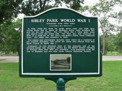
On Flag Day in 1926, two German 105mm howitzer field guns were dedicated at this Sibley Park
site as war trophies and memorials to the sacrifice made by those who served from Blue Earth County in
the First World War. These artillery pieces were . . . — — Map (db m66757) HM
This brick home sheltered the renowned novelist Sinclair Lewis in 1919. A native of Minnesota, Lewis worked on the famed book, "Main Street," while residing here. Lewis was the first American to receive the Nobel Prize for Literature in 1930. — — Map (db m66511) HM
This memorial is to honor those Dakota who created the First Mahkato Wacipi in 1972.
The Wacipi is to remember the thirty-eight Dakota executed in Mankato in 1862 and to create a spirit of reconciliation between the people of Mankato and . . . — — Map (db m17506) HM
The
Lorin & Lulu Cray Home
was given to the
Young Women's Christian Association
for the women and girls of
Mankato and vicinity
by
Judge and Mrs. Lorin Cray
1927
This property has been
placed on the
National Register . . . — — Map (db m66783) HM
Archaeology reveals the past in layers of soil here at Minneopa State Park. The artifacts below suggest that people hunted bison for thousands of years. Yet a recent turn of events removed these massive herds from daily life. Bones from slaughtered . . . — — Map (db m197043) HM
Washington Park
During the summer of 1868, the Minnesota Valley Railway Company contracted more than 500 people to grade and lay ties and tracks from Kasota to Mankato, reaching Mankato October 3, 1868.
The mainline was known as the . . . — — Map (db m66635) HM
Robert was park superintendent from 1936 - 1939 at Minneopa State Park. He supervised the Works Progress Act (WPA) projects and planted many trees that still thrive today. Frieda operated a concession stand in the park that is now a visitor center. . . . — — Map (db m226147) HM
As a member of the local advisory board of Minneopa State Park for many years, Mr. Palmer, in October 1927 instigated the planting of the plot of black walnut trees north of the railroad — — Map (db m226153) HM
Cobden is a railway village in Prairieville Township. It was originally named North Branch because of its location near Sleepy Eye Creek, the principal north branch of the Cottonwood River. In 1886 its name was changed to Cobden for the English . . . — — Map (db m69835) HM
When the Second Battle of New Ulm ended on the morning of August 24, 1862, the city lay nearly in ruins. Fearing that it would surely fall if attacked again, Colonel Charles Flandrau ordered the entire city to evacuate. The next day . . . — — Map (db m73792) HM
On April 8, 1885 Chief Engineer Blunt of the Winona & St. Peter Railroad Co. announced that the railroad had decided to build a side track between New Ulm and Sleepy Eye for the purpose of receiving grain. The site was known only as "Siding Number . . . — — Map (db m67411) HM
This tablet was erected by the Junior Pioneers in memory of the following men, women and children of the town of Milford who were massacred by the Indians during the Indian outbreak in 1862.
John Martin Fink. • Monika Fink, his wife. • Max . . . — — Map (db m67952) WM
Erected by the State of Minnesota in 1929 in the memory of the men, women and children of Milford who were massacred by the Indians, Aug. 18, 1862.
John M. Fink • Monika Fink • Max Fink • Carl Merkle • John B. Zettel • Barbara . . . — — Map (db m67951) WM
In the summer of 1862, after years of broken treaty promises and late payments that fueled growing tensions and conflict, some Dakota began an attempt to forcibly reclaim their homeland. After attacking the Redwood (Lower Sioux) Agency . . . — — Map (db m67915) HM WM
In 1850 the Minnesota Territory had a white population of about 6000. In 1858, a year before Minnesota became a state, the population was 150,000.
One of the reasons for this enormous growth was the opening of the “Suland,” land . . . — — Map (db m159781) HM
On May 24, 1887 Nels Hanson platted the small railroad station point in section 8 of Prairieville township as "Hanson Station". A post office had been established in 1886 named Evan by the first postmaster, Martin Norseth, in honor of Hanson's wife . . . — — Map (db m69831) HM
In 1854 Ole and Guri Sorbel immigrated to Rock County Wisconsin from Hallingdal, Norway. In 1856 they settled to your right on the northwest bank of Lake Linden. On September 21, 1876, Bob, Cole and Jim Younger and Charlie Pitts received breakfast . . . — — Map (db m68073) HM
In 1899, the Iowa and Minnesota Land & Townsite Company circulated a petition to locate a railroad station in Lake Hanska Township. The petition was signed by 77 people and on October 9, 1899 the village of Hanska was platted in section 24 by Harry . . . — — Map (db m66468) HM
This memorial is dedicated to the memory of John Armstrong pioneer of Linden Township, in 1857 he represented this part of Brown County as its first Territorial County Supervisor (Commissioner) and later became Linden Township's first . . . — — Map (db m68083) HM
The Sioux Indians called this lake "minne hanska," meaning "long water." The basin of the lake was formed 11,000 to 15,000 years ago by the Wisconsin glacier; the original hard clay bottom is now about 50 feet below the present surface of the . . . — — Map (db m66454) HM
Ole Synsteby was born in Lesja, Gulbrandsdalen, Norway. In the summer of 1873, the Synsteby family migrated to the Lake Hanska area. In 1879 Ole purchased the land which is now designated as Lake Hanska County Park.
The story of . . . — — Map (db m79934) HM
This structure is a replica of many such stabburs found in Norway. There are several variations. "Stabbur" translated means store house.
Benefactors: James & Ferdi Amundson estate.
These Lake Hanska farmers were descendants of Norwegian . . . — — Map (db m68264) HM
This log cabin was built about 1857 by the Omsrud/Thordson and Torgrimson families, immigrants from Valdres, Norway. It originally stood on the Thord Omsrud farm on the shores of Omsrud Lake. The cabin was moved to this site in 1986 by . . . — — Map (db m66437) HM
1917 • 1918
That freedom, law and justice
might be established thruout the Earth
This monument is erected in honor
of the men of Hanska and vicinity who answered
their country's call in the World War.
Oscar O. Haugen • John Thordson . . . — — Map (db m68256) WM
About 5 blocks north of this marker was the location of a very important river crossing for the early settlers of this area, going from the "Shetek Trail" on the south to "Old Leavenworth" and New Ulm on the north side of the Cottonwood . . . — — Map (db m67709) HM
In 1857, settlers platted a townsite in Section 14 of the Leavenworth area. During the next year, Dr. J. B. Calkins established the post office and became its first postmaster. Leavenworth Township was legally organized on April 16, 1859. Seven . . . — — Map (db m68025) HM
The Joseph Brown family with son Jonathan and daughter Oratia were early settlers on a farm five miles west of here along the Shetek Trail. The family fed and over-nighted guests, operating their home as a traveler's inn. Upon hearing news of Dakota . . . — — Map (db m67825) HM
The Church of St. Mary was incorporated on September 26, 1911 by Archbishop John Ireland of St. Paul. The Parish included Catholics living south of Center Street in New Ulm, plus Cottonwood and Courtland Townships. Because of difficult economic . . . — — Map (db m74048) HM
Christian Adam(s) was born circa 1812 in Prussia. He sailed from LeHavre, France aboard the ship Pactolus which arrived in New York City October 12, 1846. The passenger manifest listed his occupation as farmer.
Petronella Keller Adam(s) was . . . — — Map (db m73759) HM
The town gained a new venue for public events in 1873 with the opening of Arbeiter Hall. The local Arbeiterverein, or Workers' Association, organized in 1871, primarily as a workers' insurance association. The two-story brick building had a . . . — — Map (db m67093) HM
Following the outbreak of hostilities between the Dakota and white settlers on August 18, 1862, hundreds of people fled from nearby farms to New Ulm for safety. Quickly, Brown County Sherriff Charles Roos and Jacob Nix, a citizen with German . . . — — Map (db m73140) HM
Brown County, an historic gateway on the Minnesota River, opened the fertile prairie lands of the Great Plains to the northern hardwoods of a continental divide. The U.S. Territorial Legislature organized the county in 1856 from lands ceded by the . . . — — Map (db m66749) HM
The Brown County Bank is among the oldest commercial properties within the district. As the local economy recovered from the devastating effects of the Dakota Conflict, the city found itself without a bank following the demise of the First . . . — — Map (db m66879) HM
Dedicated to All Brown County Veterans
This memorial is a lasting tribute to past, present and future veterans who served during peacetime and the following conflicts: Indian Wars 1817 - 1898 ·
Mexican War 1846 - 1848 ·
American Civil War . . . — — Map (db m65526) WM
This three-story building is a fine example of Queen Anne commercial architecture. The original southern section was erected in 1892 for the Buenger Furniture Store, while the corner building was constructed in 1902.
Louis Buenger Sr. . . . — — Map (db m68117) HM
The colorful frontiersman credited with giving Minnesota the nickname of the Gopher State was born in 1828 in New York City of French Huguenot and Irish ancestry. As a young lawyer he moved to Minnesota in 1853. After exploring the Minnesota River . . . — — Map (db m206944) HM
Rosa Schnobrich opened the City Meat Market in 1907 with the advertising slogan, "Better Meats, Cleaner Meats, and Quicker Service." Her sausages, in particular, proved popular, and soon her shop began supplying a network of wholesale dealers . . . — — Map (db m68267) HM
1864 marked the beginning of District 6 (later known as 179), Sigel township's first of four school districts. The first schoolhouse was built on this site in 1868 with the purchase of 1 acre of land for $10. Civil War general Franz Sigel visited . . . — — Map (db m74233) HM
Colonel Wilhelm Pfaender (1826-1905), born in Heilbronn, Wurttemberg, Germany, came to America as a result of the 1848 Revolution. In Germany he helped found the Turner Societies in his birth-city of
Heilbronn and in Ulm. In Cincinnati, Ohio, he . . . — — Map (db m73673) HM
For years, the Crone store was the largest mercantile establishment in New Ulm. In 1857, Theodore Crone Sr. opened his general store at the corner of Broadway and Center Streets. Twelve years later, he erected this building, adding a . . . — — Map (db m66864) HM
The Dacotah House, located on this site, was built in 1859 by Adolph Seiter and Frank Erd. Adolph's wife, Helena Erd Seiter soon established her fame in the kitchen. During the Dakota Conflict of 1862, Helena fled in a wagon with her children to . . . — — Map (db m66377) HM
This monument is erected by the State of Minnesota to commemorate the battles and incidents of the Sioux Indian War of 1862, which particularly relate to the town of New Ulm.
1890.
Honored be the memory of the citizens of Blue Earth, Nicollet, . . . — — Map (db m66990) HM WM
Lest we forget.
In sacred memory of the soldiers, sailors, and marines who served their country in time of war. Erected in 1941 by Veterans of Foreign Wars U.S.A. Albert Nagel Post No 1648 and Auxiliary. — — Map (db m68739) WM
Frank Erd and his wife, Louise, came to New Ulm from Cincinnati. Frank, whose father was an architect, erected a substantial store, one of the few brick buildings in the city. The Brown County supervisors kept their offices in Erd's building, . . . — — Map (db m66897) HM
Valentine Sommereisen was the first resident Catholic priest in three large areas of the American West: southwestern Minnesota, the Dakota Territory, and western Kansas. Born 28 May 1829 in Rouffach, Alsace, a German–speaking part of eastern . . . — — Map (db m74222) HM
The second battle of New Ulm took place on August 23, 1862. About 650 Dakota Indians surrounded the town, while over 2,000 people were crowded behind a barricade. The attack began around nine in the morning and the Dakota Indians quickly encircled . . . — — Map (db m66402) HM
Frederick Forster came to the United States in 1850 and taught school in New York. He moved to New Ulm in 1858, where he continued teaching, becoming the city's postmaster in 1861.
In 1860, Forster purchased this lot and the following . . . — — Map (db m68227) HM
Frederick Forster, who conducted the New Ulm Pottery here with Frances Gommel, was also the Postmaster. This building, used as a combined pottery works, Post Office and dwelling, was a very important defense outpost in 1862.
During the . . . — — Map (db m162175) HM
Goosetown began forming around the flour mills, brewery, and railroad tracks circa 1870. Settlers were largely German-Bohemian Catholics of peasant stock who farmed and worked in nearby industries. Inhabitants kept geese which were free to roam, . . . — — Map (db m58435) HM
This monument was erected in 1991 by the German-Bohemian Heritage Society to commemorate the immigrants to this region from the German speaking western rim of present-day Czechoslovakia. They emigrated from the counties of Bischofteinitz, Mies and . . . — — Map (db m67030) HM
The first structure built on this site was the Minnesota Haus, the first hotel in New Ulm, built in 1856 by Phillipp H. Gross. That early structure was destroyed and in 1860, on the same sight, Gross built the Union Hotel, a two and a half story . . . — — Map (db m67981) HM
By the end of the fighting in New Ulm, the U.S.—Dakota War of 1862 had taken a heavy toll on the town. More than 50 settlers had been killed and 36 wounded, along with an unknown number of Dakota. In addition, at least 190 of the . . . — — Map (db m74136) HM
West Newton in 1870 was a thriving town, serving riverboat travel on the Minnesota River. It consisted of a hotel, a livery stable, a brewery, a sawmill, a wagon works, two blacksmith shops, three saloons, and many dwellings that made the town an . . . — — Map (db m66238) HM
This footprint is rumored to be that of
Hermann the German-possibly dating
back hundreds of years. Found evidence
suggests that touching the print means
you'll have more fun. Being big fans of
fun, the City of New Ulm declared it a
public . . . — — Map (db m173537) HM
Hermann (Arminius) of the Cherusci tribe led several German tribes in battle against their Roman conquerors in 9 A.D., and defeated them in the hills of Teutoburg Forest near present Detmold. To later unified Germany, Hermann . . . — — Map (db m65467) HM
Stan Wilfahrt – an outstanding player for New Ulm's 1941 State Legion Champs & 1943 Brewers State Amateur Champions. He coached baseball at Cathedral High School for 1957-1978 with a 246-68 (.783) record. His teams appeared in nine state . . . — — Map (db m79894) HM
On this date at Chaska, Minnesota, New Ulm High School coach James Senske recored his 510th coaching victory, a new Minnesota State High School League baseball record for wins by a coach. At the completion of the 1994 season, . . . — — Map (db m79913) HM
Jacob Nix from Bingen Am Rhein in Germany was a key figure in the defense of New Ulm in 1862. Born in 1822, Nix early joined the push for a united Germany under a republican form of government. During the ill-fated 1848 Revolution, Nix served as . . . — — Map (db m65455) HM
This home was built by John Lind in 1887 and was a significant cultural, social and political center built on a prominence above early New Ulm. Swedish born Lind came to America and Minnesota in 1867 at age thirteen. While very young he was a . . . — — Map (db m65399) HM
The quality of life in New Ulm improved notably after a young teacher-coach accepted a position at New Ulm High School in 1928. During the succeeding 51 years, "Joe" Harman provided the inspiration that left this community a better place in which to . . . — — Map (db m66381) HM
In the early 1870's, fourteen settlers purchased this beautiful spot located on the north bank of the Big Cottonwood River and named it Jägers Ruhe (Hunters' Rest). The objectives of this group of hunters was to preserve this property for their . . . — — Map (db m66087) HM
The Kiesling House is one of the three downtown buildings in New Ulm to survive the Dakota War of 1862. Frederick W. Kiesling, blacksmith and ferrier, had built the modest frame house ($125) the year before the outbreak of the war. In August of . . . — — Map (db m65497) HM
During the Minnesota Sioux Uprising of 1862, eighteen men left New Ulm early on the morning of August 19, and travelled westward about 20 miles along the Big Cottonwood River to the area of Leavenworth. Searching for relatives and friends, they . . . — — Map (db m65486) HM WM
In 1914, two four-inch naval cannon barrels, each with a pyramid of balls, were placed on the courthouse grounds as a tribute to all Brown County citizens who served their nation in time of conflict. The United States Government reclaimed them in . . . — — Map (db m66967) HM WM
In 1851, leaders of the Dakota Nation signed the Treaty of Traverse des Sioux with the United States Government. This treaty opened new lands in Minnesota Territory for settlement. Two years later, German immigrants in Chicago, led by Frederick . . . — — Map (db m65452) HM
Schonlau Park, named in honor of Theodore H. and Clara K. Schonlau, is the setting for the City of New Ulm’s unique Glockenspiel. Local contributors were joined by donors from three foreign countries, 31 States, and 51 other Minnesota cities, in . . . — — Map (db m65492) HM
Frederick Beinhorn and Wilhelm Pfaender, pioneer founders of the prairie colony of New Ulm, were cut of the same cloth. Both came to America from Germany after the 1848 Revolution in Central Europe failed to unite German peoples under a new frame of . . . — — Map (db m65694) HM
east side
In memory of our honored brave who fell in defence of The Union.
north side
In memory of those who fell in defence of New Ulm 1862.
west side
In memory of those massacred by the Indians in Brown Co. . . . — — Map (db m68705) WM
While crossing this ravine a
recruiting party of the Civil War
was ambushed by the Sioux
Indians on August 18th, 1862, at
the noon hour.
The following were killed or
mortally wounded:
John Schneider • Ernest Dietrich . . . — — Map (db m73704) HM WM
On this site in 1859 Frederick Roebbecke built a seventy foot high wooden windmill for grinding corn and grain. Situated on a prominent ridge, it commanded an excellent view of the scattered settlement. Barricaded with sacks of flour and grain, the . . . — — Map (db m65400) HM
In 1874, shortly after George Kuhlman arrived in New Ulm, he constructed a home on this site. The same year, he was appointed as Brown County’s Attorney to fill a one-year opening left by his predecessors death. In addition to his legal vocation, . . . — — Map (db m153851) HM
To pay homage to the sturdy pioneers who founded the territory of Minnesota a century ago. And to express veneration for the pioneers of Brown County and members of their families who lost their lives during the Sioux War of 1862 — 1863. . . . — — Map (db m73642) HM WM
This neighborhood dates back to the early days of New Ulm. Oral history suggests the borders shown above. The origin of the name “The Wallachei” is obscure. The most likely translation is “low land horse pasture.” Or, legend . . . — — Map (db m65396) HM
The Turner concept of developing a sound mind and body through discussion of common problems and physical exercise was conceived by Frederick Jahn of Berlin in 1811. It was an effort to strengthen German resolve against the French conqueror, . . . — — Map (db m65426) HM
Von hier 717 fuss in der Richtung des Pfeils wurde am 11ten November 1856 der New Ulmer Turnverein gegruendet.
(From here, 717 feet in the direction of the arrow on the 11th of November 1856 the New Ulm Turnverein . . . — — Map (db m66239) HM
The first news of the Sioux Uprising was brought to New Ulm at noon on August 18, 1862, by survivors of a Civil War recruiting party that had been ambushed in Milford Township. Barricades were hastily erected in a three-block area on Minnesota . . . — — Map (db m65402) HM
The federal government erected the post office building in 1910, designed by James Knox Taylor, the supervising architect of the United States Treasury. Although the city's postal service began in 1856, it had been located in rented space . . . — — Map (db m74074) HM
The first river steamboat, WEST NEWTON, passed by here in 1853 going upriver with troops to lay out the site of Fort Ridgely. Two days later TIGER and CLARION followed with men and supplies.
For the . . . — — Map (db m66383) HM
Henry A. Subilia, a native of Jean, Italy, constructed the Waraju distillery in 1861. The construction cost total of $8,000, plus $2,000 for furnishings. The building required approximately 200,000 bricks and measured 72 feet x 46 feet. It obtained . . . — — Map (db m153916) HM
In 1857, Rev. August Huelster held the first Evangelical church service at the home of Charles Lauer in Cottonwood Township. In 1865, two acres of land were purchased in Cottonwood Township by John Mohr, Philip Pfisterer & Carl Schreyer, . . . — — Map (db m78463) HM
Searles, a small community in Section 21 of Cottonwood Township, was platted on October 10, 1899, by Harry and Anna Jenkins. It was a railroad station point named by officials of the Minneapolis and St. Louis Railroad.
The original plat . . . — — Map (db m67914) HM
Sleepy Eyes, or Drooping Eyelids, was born about 1780 in a Sisseton Sioux Indian village at Swan Lake in Nicollet County. The Bureau of Indian Affairs commissioned him a chief in 1824. His fame was achieved not as a warrior or hunter but as a friend . . . — — Map (db m67658) HM
In the summer of 1851 the Dakota Indians, a group of Native Americans who lived in Southern Minnesota, sold their land, 35 million acres, to the United States for $3,000,000. The Dakota agreed to move to a reservation which included land ten miles . . . — — Map (db m67983) HM
The village of Golden Gate occupied this area for some years. The town took its name from the U.S. Post Office established in 1868 with Ebenezer Fuller in charge.
Construction of a water-powered grist mill on Spring Creek in 1869 by . . . — — Map (db m70993) HM
The mill, built in 1867 by John Heimerdinger, was down 1/4 mile from Golden Gate on the Ruhe-Heim Creek. It was powered by a pond kept full by many wells, dug by hand. Wheat was ground by stones into flour and feed. — — Map (db m71062) HM
In 1866 the budding village of Iberia had a log school house, four frame buildings and a cemetery. The settlement is the center of Stark Township, organized in 1866.
Iberia crossroads was named for a community in Ohio because many of the first . . . — — Map (db m73752) HM
In honor of the
Brave Service Men & Women
who have defended and
continue to defend the
United States of America.
Sons of John & Mary Broich
Chris USNR, Art USNR, Walter USAF, Joseph . . . — — Map (db m67856) WM
In the 1850s there was a land boom in southern Minnesota. Jonathan Brown, 37 years old, filed on land along the Cottonwood River in what is now Burnstown Township. (S 1/2 of SW 1/4, Sec. 15; N 1/2 of NW 1/4 of Sec. 22)
Jonathan picked a good . . . — — Map (db m67820) HM
John and Daniel Burns were pioneer settlers in this area of brown County. Burnstown Township was named in their honor.
Railroad construction advanced westward and the name of the station stop here in 1873 was "Burns." A small settlement . . . — — Map (db m67542) HM
Proudly, we salute our veterans and
pledge eternal gratitude for their sacrifices and
gallant preservation of freedom for all.
seals of the United States Army • Air Force • Navy • Marine Corps • Coast Guard
Dedicated July 4, 1994 . . . — — Map (db m71172) WM
This point overlooks the St. Louis River Valley. The steeply inclined rocks in the river channel upstream are alternating beds of slates and graywackers of the Thompson Formation thousands of feet thick.
. . . — — Map (db m44627) HM
540 acres of land southwest of this point, embracing Silver Creek in Jay Cooke State Park are dedicated to the memory of this pioneer civic leader who made great contributions to the establishment and development of this park.
Lands donated by . . . — — Map (db m53599) HM
One half mile south of this point lie three islands, known as numbers 1, 2, & 3, in the St. Louis River, which were settled by Josiah Boardman Scovell, original U.S. patentee in 1881, who retained ownership for the balance of his life.
Islands . . . — — Map (db m53857) HM
In memory
of the Finnish pioneers who arrived here in the western part of Carlton County in 1872 and thereafter, and made their homes with courage and perseverance.
Erected 1952 by Minnesota Finnish American Historical Society Chapter No. . . . — — Map (db m3266) HM
On October 12, 1918, a massive forest fire raced through northeastern Minnesota from Sturgeon Lake to the shores of Lake Superior north of Duluth. When it was over, this region had suffered through one of Minnesota’s worst disasters.
Weather . . . — — Map (db m3031) HM
2019 entries matched your criteria. Entries 101 through 200 are listed above. ⊲ Previous 100 — Next 100 ⊳