[Top plaque] United Methodist Historic Site No. 80
[Bottom plaque] This property has been placed on the National Register of Historic Places by the United States Department of the Interior — — Map (db m243643) HM
"Soldiers Retreat," located here, was the home of Ferdinand Leigh and Magdaline Claiborne. F.L. Claiborne (1772-1815) moved to the Mississippi Territory from Virginia in 1807 and served as Brig. Gen. with the 1st Mississippi Volunteers during the . . . — — Map (db m105260) HM
(side 1)
One of the deadliest fires in American history took the lives of over 200 people, including bandleader Walter Barnes and nine members of his dance orchestra at the Rhythm Club (less than a mile southeast of this site) on April 23, . . . — — Map (db m70811) HM
The 1928 Natchez City Directory lists Italian immigrant Sam Anzalone as operating a grocery store at 158-160 St. Catherine Street where he sold gasoline for 21 cents a gallon. Many of the late- nineteenth-century Italian immigrants farmed and sold . . . — — Map (db m114509) HM
. Eliza Smith, an antebellum "free woman of color," purchased property on St. Catherine Street in the 1850s. Her daughters and their families built new houses on the property in the 1880s.28 St. Catherine Street (above) was the ca. 1885 home of . . . — — Map (db m108276) HM
300 North Martin Luther King Street (above) is home to the city's oldest funeral business.Robert D. Mackel (below) opened Bluff City Undertaking in 1898 at the corner of Jefferson and North Rankin Streets. About 1911 he relocated the business to . . . — — Map (db m108600) HM
The Stietenroth House is the last remaining example of a
number of residential buildings that once lined the western side
of South Canal Street. In the late 1800s and early 1900s,
Natchez families and real estate developers constructed . . . — — Map (db m196178) HM
The Abandoned Mound (designated “Mound A”) remains a mystery. Numerous French colonial narratives describe the other two mounds at the Grand Village but fail to mention this mound. The Natchez Indians apparently stopped using this mound . . . — — Map (db m114672) HM
”Lest we forget – lest we forget”
To the boys who wore the grey.
Erected by the Natchez Chapter No. 304
Daughters of the Confederacy
January 19, 1950
Commemorating those who left from
Natchez and Adams County
Mustered . . . — — Map (db m127098) WM
Four score and seven years ago our fathers brought forth on this continent, a new nation, conceived in Liberty, and dedicated to the proposition that all men are created equal.
Now we are engaged in a great civil war, testing whether that . . . — — Map (db m144113) HM WM
The Union School (above) was the first public school built by the City of Natchez for African American students. Built in 1871 by contractor P. E. Willman, the Union School was a grand brick edifice which stood at the southeast corner of North . . . — — Map (db m115615) HM
Professional dealers, traffickers and speculators, by purchase, by hook, crook and sometimes outright kidnapping, tore apart mothers, fathers, daughters, sons, brothers, sisters, uncles, aunts, cousins, babies, young children, relations and friends . . . — — Map (db m114508) HM
Site of the printery of “father of Mississippi journalism.” Printed first book in state, 1799. Became first public printer and in 1802 founded famed newspaper, “Mississippi Herald.” — — Map (db m70851) HM
has been designated a National Historic Landmark
This site possesses national significance in commemorating the history of the United States of America
1975
National Park Service
United States Department of the Interior
[Second . . . — — Map (db m243744) HM
Don Bernardo de Gálvez, Spanish Governor of Louisiana, 1776-1783, in a brilliant campaign, with the aid of regular troops, militia, volunteers, and a few Americans, captured Baton Rouge from the British on September 21, 1779. Terms included the . . . — — Map (db m76211) HM
Jackson State University was founded here in 1877 in the former U.S. Marine Hospital. Known as the Natchez Seminary, the school was founded by the American Baptist Home Mission Society and the Mississippi Baptist Convention Association led by H.P. . . . — — Map (db m143710) HM
In 2012, the Diocese of Jackson celebrates the 175th anniversary of its founding by Pope Gregory XVI. The Bishop's Prayer Garden, located on the old catholic burial ground, is dedicated in this year to the seven deceased Bishops of Natchez who . . . — — Map (db m115630)
The Richard Wright historic marker recognizes the city’s most famous 20th-century writer. Born in 1908 on a cotton plantation near Natchez, Wright spent his early childhood in town in the home of his grandparents at 20 East Woodlawn . . . — — Map (db m87176) HM
When the Spanish laid out the town of Natchez about 1790, they set aside land on the bluff for use as a public park. In 1839, after the city had sold off most of the park and built Broadway Street, writer Joseph Holt Ingraham complained . . . — — Map (db m87177) HM
The Yazoo and Mississippi Valley
Railroad built the passenger station on
the bluff shortly after 1910, and the
Illinois Central Railroad was the last
railroad to own it. Like many smal
towns across America, Natchez lost
passenger . . . — — Map (db m118303) HM
Bontura, built in 1851, was the home of Robert Smith, a free African American who ran the city’s most successful carriage business in the 1850s. The house stands at the head of Silver Street, which leads to Natchez Under-the-Hill. Smith . . . — — Map (db m87179) HM
This circle of wooden columns sat astride a major road and held the booths where drivers paid their tolls to cross the first bridge that connected Natchez, Mississippi and Vidalia, Louisiana. It opened to traffic on September 26, 1940. . . . — — Map (db m137181) HM
(side 1)
Clarence “Bud” Scott, Sr., led one of the most popular dance bands in the Mississippi-Louisiana region for several decades beginning around 1900. Scott (1876-1938), a lifelong Natchez resident, was renowned among both . . . — — Map (db m70852) HM
Archaeological and historical evidence indicates that the Grand Village of Natchez Indians was not really a "village." It was the main ceremonial mound center for the Natchez Indians during the period of French exploration and colonization of the . . . — — Map (db m104481) HM
The original appearance of Mt. Sinai Baptist Church is visible in a ca. 1930 historic photograph. The church featured corner towers crowned with domes.Mt. Sinai organized in 1913 and built the church soon afterwards. Like most historic African . . . — — Map (db m108636) HM
Built ca. 1836, this structure, a National Historic Landmark, is a fine example of the Greek Revival style. A Banker’s House attached to the rear insured security & gives the structure an unusual and practical plan. — — Map (db m79346) HM
War with the French forced the Natchez Indians to abandon the Grand Village and their other settlements. The war arose from disputes between the Indians and the French over debts and land ownership. In 1729, the Natchez abruptly switched their . . . — — Map (db m108778) HM
Mrs. Egbert Jones and Mrs. Ferriday Byrnes, members of the Mississippi State Society Daughters of the American Revolution (DAR), played important roles in the development of the Natchez Trace Parkway. Mrs. Jones, of Holly Springs, State Regent 1906 . . . — — Map (db m42629) HM
Henry Dumas poses on the front steps of 69 St. Catherine Street. Henry managed the Dumas Pharmacy at 707-09 Franklin Street, a building that also housed the medical practice and sanitarium of his brother Dr. Albert W. Dumas, Sr. In 1940 Dr. Dumas . . . — — Map (db m115637) HM
Home of the first African American Physician in the Natchez area, Built in the 1880's Has been placed on the National Register of Historic Places by the United States Department of Interior. — — Map (db m226651) HM
The Dr. John Banks House was built in the Queen Anne style about 1890 and was slightly remodeled in the Colonial Style after about 1905. Frank Robinson, grandson of Dr. John Banks, retired part time to Natchez and restored the house in the . . . — — Map (db m106297) HM
(Front Side)
The Ealey family of Sibley has produced some of the most talented musicians to emerge from the Natchez area. Brothers Theodis, YZ, and Melwyn Ealey performed together locally in the band YZ Ealey and the Merry Makers in the . . . — — Map (db m87181) HM
In 1863 the United States War Department painted a master stroke with the implementation of the Anaconda Plan which called for blockading of over 3,400 miles of coastline and control of the Mississippi River.
The Plan was successful in its mission . . . — — Map (db m199604) HM
Site of the South's second largest slave market in the 19th century. Enslaved people were also once sold on city streets and at the landing at Natchez Under the Hill. Natchez slaves were freed in July, 1863, when Union troops occupied the city. The . . . — — Map (db m37433) HM
A
half century before the United States legally
abolished the importation of "slaves" directly from
Africa in 1807, the northeastern colonies of Massachusetts, New York, New Jersey, Pennsylvania, Delaware,
Maryland and Virginia were engaged . . . — — Map (db m199601) HM
[Panel 1:]
Natchez in the Center of Slavery
Slavery is central to American history. The labor of enslaved African Americans built much of the nation’s wealth and enabled it to gain its economic independence. The enslavement of people . . . — — Map (db m41533) HM
On bluff to south stood Ft. Rosalie, established by the French in 1716. Became nucleus of settlements from which the Miss. Territory was founded. Near this marker stood the French warehouse that was a center of bloodshed during the Natchez Massacre . . . — — Map (db m126870) HM
In 1940, Natchez native Jefferson Davis Dickson built a
"reconstruction" of Fort Rosalie as a tourism attraction to
appeal to the city's early automobile-driving visitors. A World
War I flying ace and sports promoter, Dickson built several . . . — — Map (db m196846) HM
English: French retaliation for the uprising was swift. In 1730, the French engaged with Choctaw warriors to pin down the Natchez in two fortifications that they had constructed near the Grand Village ceremonial mound site while . . . — — Map (db m138005) HM
Occupied 1716-circa 1800 by successive French, British, Spanish and American garrisons during struggle for control of the Miss. River Valley. Nucleus of early settlements in the Natchez District.
Mississippi Department of Archives and . . . — — Map (db m126797) HM
Here are buried the families of Winthrop Sargent, 1st Gov. of the Mississippi Territory, and Seargent S. Prentiss, Congressman. "Let no monumental marble deface with its mock dignity the patriot's grave." — — Map (db m103804) HM
Louis and Anna Alexander resided in the craftsman style cottage (above) at 17 St. Catherine Street.Until his death in the late 1940s, Louis Alexander worked at the historic mansion Melrose for George and Ethel Kelly. He died during a trip to . . . — — Map (db m115953) HM
Of the six mounds identified on the early 18th-century maps of the Grand Village, three remain. Mound A is now eroding into St. Catherine Creek. Mound B is a pyramidal platform mound, roughly seven feet tall, built in four stages. Each stage served . . . — — Map (db m103758) HM
The Natchez Indians used the open area between the Great Sun's Mound and the Temple Mound for religious and social ceremonies. In 1725, the funeral ceremonies for the Tattooed Serpent, brother of the Great Sun, were held on this plaza.
Le Page Du . . . — — Map (db m110549) HM
Eyewitness accounts of American Indians using ceremonial mound centers are very rare. In 1704, French colonists witnessed the funeral rites for a female Natchez chief at the Grand Village. The Natchez held a similar funeral ceremony here in 1725 . . . — — Map (db m114668) HM
The Natchez chief called the Great Sun lived in a house on Mound B. The Jesuit missionary Pierre- François-Xavier de Charlevoix wrote that the Natchez houses were square or rectangular in floor plan with mud walls plastered on a wooden frame. Roofs . . . — — Map (db m114666) HM
Pre-Civil War St. Catherine Street The road, for the first mile, after leaving town, passed through a charming country, seen at intervals, and between long lines of unpainted, wretched looking dwellings, occupied as 'groggeries' by free . . . — — Map (db m106918) HM
First Catholic church in the Mississippi valley with entire congregation of Afro-American descent. Its school has been continually educating youth since 1890. — — Map (db m103798) HM
In 1889 Bishop Thomas Heslin started the first parish for Roman Catholic African Americans in Mississippi. He first oversaw construction of a small frame church (above left) on Beaumont Street and brought Father A.N.J. Peters to Natchez to become . . . — — Map (db m104502) HM
The portion of St. Catherine Street that extends from the site of the Rhythm Night Club to D'Evereux Street was originally part of the property of the city's first public hospital (above).The hospital fronted St. Catherine and stood on a hill on . . . — — Map (db m108586) HM
1830: July 18-December 30- The Blessed Virgin Mary appears to St. Catherine Lebouré, Daughter of Charity, in Paris, France 1830: July 27 Revolution - Louis Philippe overthrows King Charles X of France 1832: - First Miraculous . . . — — Map (db m104067) HM
Myrtle Terrace (behind you) was the home of steamboat captain Thomas P. Leathers, who commanded the steamboat Natchez in a race with the Robert E. Lee in 1870. An internationally known riverboat pilot, Leathers worked for . . . — — Map (db m127107) HM
This 1866 view of High Street shows two houses, but one is no longer standing. The surviving house in the foreground has porches with the kind of sawn wooden railing that is called “gingerbread,” because it looks like the . . . — — Map (db m127099) HM
Joseph Neibert built Choctaw in 1836 as his mansion townhouse. Neibert was a cotton planter. In the 1830s he and his partner Peter Gemmel, operated the city's most successful building firm, which employed both white and enslaved . . . — — Map (db m104476) HM
John Smith, a partner in the contracting firm of Neibert and Gemmell, built this brick cottage in 1838. The John Smith House is named for two owners with this same common name. In this 1866 photograph, evergreen trees obscure the front of . . . — — Map (db m127078) HM
Zion Chapel African Methodist Episcopal (A.M.E.) Church was built in 1858 as the Second Presbyterian Church, a mission of First Presbyterian Church. Zion Chapel acquired the building in 1866, when Hiram R. Revels served as pastor. The . . . — — Map (db m127093) HM
Ethel Clagett and Mabel Porter were among the first women in America to own a car dealership that was not inherited from a male spouse or relative. They opened their dealership in 1914 on Main Street and moved to a larger new facility on . . . — — Map (db m108610) HM
The Protection Steam Fire Company No. 3 built a grand firehouse in 1902 at the corner of Main and Canal streets (no longer standing). During the 1800s and early 1900s, volunteers provided fire protection in Natchez as in most American . . . — — Map (db m127086) HM
The 1927 Eola Hotel is the tallest building in downtown Natchez. Named for Eola Levy, the daughter of developer Isadore Levy, it became a center for social activity for the city. Celebrities who visited the hotel in the mid-1900s . . . — — Map (db m114303) HM
The Natchez Institute, built in 1901,
replaced an 1845 school building. The
Natchez Institute was the first
public school in Mississippi to offer a
full course of free education for white
children. The first public school . . . — — Map (db m127142) HM
An 1890 view of Memorial Park shows the Confederate soldier monument draped for unveiling. Like many others across the south, it faces north towards the opposing army.The park's creation was part of the Lost Cause Movement that expressed . . . — — Map (db m104480) HM
The Old Natchez Post Office was built in 1904 on the site of William Johnson's Main Street barbershop. Before his 1851 death, Johnson also owned two other barbershops in town. He used both freed and enslaved black workers who served only . . . — — Map (db m127074) HM
On this hill, Andrew Ellicott raised the American flag in 1797. This act claimed the Natchez Territory for the United States and helped hasten the departure of the Spanish. A few years later, James Moore built a home on the site, known today as the . . . — — Map (db m114446) HM
The dramatic looking Natchez Hotel (no longer standing) was built in 1891. Within a few years, parts of the building began to disappear in stages. The tent-like dome went first in a storm, and a 1926 fire destroyed most of the structure. . . . — — Map (db m127090) HM
In the 1800s, Franklin Street was
headquarters for plantation supply
houses, and the street was filled with
wagons. Main Street merchants offered
house wares and dry goods, and it
attracted more carriages. Many of the
downtown . . . — — Map (db m199493) HM
Edelweiss is a Swiss Chalet-style building which dates to 1883. The house offered both a great view of the Mississippi River and a convenient location for the family of its first owner, Joseph O'Brien, a coal-dealer at Natchez . . . — — Map (db m108807) HM
William Johnson, a freed person of color, was a barber, entrepreneur, and slave owner. He built this house in 1841 using materials salvaged after the 1840 tornado that damaged much of downtown. His diary details its construction and . . . — — Map (db m115610) HM
Institute Hall was built in 1852-1853 as a public auditorium and a companion building to the Natchez Institute. The contractors were the Weldon Brothers, who used over 100 enslaved craftsmen and whose head draftsman was a slave named . . . — — Map (db m115628) HM
The domed Federal-style Adams County Courthouse appears in Audubon's 1822-1823 painted landscape of Natchez. Built in 1817, this courthouse is the oldest in Mississippi. It was remodeled in 1925. Actions at the courthouse impacted all of . . . — — Map (db m114502) HM
The present Temple B'nai Israel, built in 1904, replaced an 1870s temple that burned (pictured above). Both reflect the success of Jewish merchants after the Civil War. Jews lived in Natchez as early as the late 1700s, but their numbers . . . — — Map (db m114299) HM
An 1866 photograph shows that the porch on the house at 705 Washington Street (behind you) was a later addition. Those who built houses without porches often soon added them. Travel writer Joseph Holt Ingraham noted in 1835 that the area's hot . . . — — Map (db m115604) HM
The two matching brick houses at the corner (behind you) date to 1901 and stand on the site of a brick chapel (no longer standing) built in 1849 by the First Presbyterian Church. The chapel held Wednesday evening prayer services, . . . — — Map (db m107249) HM
Gathered on the front steps of Green Leaves are the founders of the Natchez Garden Club, the women who started the local historic house tours in 1932. The vision of these women created the city's heritage tourism industry, today a major . . . — — Map (db m115605) HM
All four of the houses at this intersection were built before the Civil War, and three are associated with the family of Joseph Quegles, a Spaniard who settled in Natchez during the Spanish period (1779-1798).Four houses near the . . . — — Map (db m114301) HM
Known as the Spanish Quarter in the early 1800s, this neighborhood is one of the oldest in Natchez. Each corner house dates to before the Civil War.
A Spaniard, Manuel Texada, built the house called Texada . . . — — Map (db m127092) HM
This was the first Methodist congregration in Natchez formed in the early 1800s, and the 1st building was constructed in 1807. The 1st Sunday School south of Philadelphia, Pa., was organized here in 1829. — — Map (db m29749) HM
Erected, 1968, by Descendants of the New Jersey Settlers Organization (formed 1940) in memory of settlers of 1772, including Captain Amos Ogden. The Swayzes, Thorns & others now rest in the Kingston Cemetery — — Map (db m103816) HM
Erected, 1968, by Descendants of the New Jersey Settlers Organization (formed 1940) in memory of settlers of 1772 & their descendants who rest in Caleb King & Daniel Farrar Cemetery, Kingston Plantation. — — Map (db m104044) HM
John R. Lynch turned to writing in his later years and wrote the Facts of Reconstruction in 1913. He completed his autobiography Reminiscences of an Active Life when he was 90, two years before his death in 1939.Lynch invested . . . — — Map (db m115927) HM
An early American feminist writer and champion of women's rights, Murray (1751-1820) was also instrumental in fostering the Universalist Church in America. Murray lived for two years at Oak Point Plantation on this site. She died on July 6, 1820, . . . — — Map (db m103817) HM
Oldest building in Natchez. Standing before 1789. Operated as a tavern, stage stop, and mail station at the end of Natchez Trace. Now owned and restored by the Pilgrimage Garden Club of Natchez. — — Map (db m127081) HM
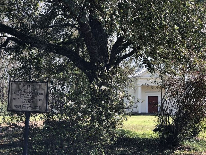
S.E. 1 mile is site of Old Jersey Settlement now known as Kingston. Here settlers from New Jersey organized first Protestant church in Mississippi with Samuel Swayze as pastor. — — Map (db m104043) HM
E. 8 mi. Settled, 1773 by N. Jersey pioneers led by Richard and Samuel Swayze. Latter formed Congregational church, reputedly the first Protestant church in state. — — Map (db m120192) HM
8.8 Miles to KINGSTON First Protestant Settlement In Mississippi Territory 1773.Dedicated 1955 by The National Society Of The Colonial Dames of America In The State Of Mississippi. — — Map (db m120264) HM
On April 18, 1825, General Lafayette visited Natchez, spoke on the Bluff, dined at The Steamboat Hotel & attended a ball at Traveller's Lodge. — — Map (db m192867) HM
[Top plaque]
Presented to
the Pilgrimage Garden Club
Natchez Mississippi
by the Kelly E. McAdams Foundation
Austin, Texas
1970
[Bottom plaque] Longwood has been designated a Registered National Historic Landmark under . . . — — Map (db m243661) HM
The photograph of the 1946 Brumfield High School Choral. Club, taken in the front yard of Brumfield, provides the best image of the Louis Winston House on the left. The house unfortunately burned in the 1990s. The house on the right, which still . . . — — Map (db m114661) HM
Explored, 1540-1, by De Soto. Colonized first by French, 1699. Became a colony of British, 1763; Spanish, 1779. Territory organized by U.S., 1798. Became 20th. state, 1817. — — Map (db m103799) HM
2989 entries matched your criteria. The first 100 are listed above. Next 100 ⊳