The first courthouse of Adair County, completed on July 15, 1843, was constructed on the northwest corner at the intersection of Harrison and Elson Streets. Described as "a low brick affair," the building was said to cost $1,000, a large amount of . . . — — Map (db m144751) HM
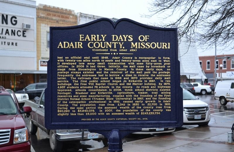
(side 1)
Confederate Lieutenant Colonel Joseph C. Porter of Lewis County had been recruiting and harrying in Northeast Missouri throughout the summer of 1862. Adair County farmer Captain Mathias (Tice) Cain (Confederate), in command of . . . — — Map (db m144750) HM
The first attempt at a settlement by Whites in this county was in 1828, twenty-five years after the Louisiana Purchase and three years after extinction of the Indian title. Settlers from Howard County decided to locate on the east side of the . . . — — Map (db m144764) HM
On April 27, 1899, at 6:20 p.m. a monstrous killer cyclone approached Kirksville from the southwest taking dead aim on the new Adair County Courthouse. Suddenly, the cyclone veered more to the northeast, making a clear path of destruction from the . . . — — Map (db m144767) HM
Andrew County, organized 1841, is one of 6 counties in the Indian Platte Purchase Territory annexed to Missouri, 1837. Named for Andrew Jackson Davis, St. Louis editor, the county was first settled in the middle 1830’s. Pioneers were from Ohio, . . . — — Map (db m39756) HM
Members of the Christian Church in Savannah have worshipped in four different buildings — all located on this half-block of land. 1. 1847 — Church organized. Members met in the Courthouse, located near Sixth Street. 2. 1852 — The first church was . . . — — Map (db m216797) HM
Formed during the Glacial Period. Weighs about a Ton. Removed from Bethel Church Road east of Highway 71 and North of 48 by County in 1941. Removed and placed here by Andrew County and Fred M Clark of Clark Construction Co. in September 1941 for . . . — — Map (db m43018) HM
This local church, a part of the American religious movement known as The Disciples of Christ, was organized in 1847 and since its beginning has been a fellowship of over 5000 members. This present location, Fifth and Market Streets, has been the . . . — — Map (db m216796) HM
Federal Emergency Administration of Public Works Franklin D. Roosevelt President of the United States Harold L. Ickes Administrator of Public Works — — Map (db m216754) HM
Atchison County Citizens
have left and will continue
to leave their footprints
around the world
Bravery • Courage
Hope • Duty
Liberty • Service
Dedicated November 11, 2008 — — Map (db m48118) WM
To the men and women
of Atchison County who
offered, and those who
gave their lives in the
cause of peace.
[Roll of Honored Dead]
[War Memorial Building Cornerstone]
To the boys of Atchison County
who gave, and offered their . . . — — Map (db m48115) WM
Side A:
Here on Rock Creek in Missouri's fertile Glacial Plains, Rock Port was laid out, 1851, by Nathan Meek and succeeded Linden as seat of Atchison County, 1856. A leader in corn production, the county, organized 1845, is named for U.S. . . . — — Map (db m48107) HM
Here rests a faithful servant of our company retired on account of age after twenty two years of continuous loyal service.
It is a Bonnot Combined Brick Machine installed at the East Plant in 1904 and moved to Josephine Plant in 1917. During . . . — — Map (db m70494) HM
This is the largest "surface boulder" of Diaspore found in the Missouri Diaspore Fields lying south of the Missouri River. - It was taken from a diaspora pit near Aud, Osage County, Missouri, in 1926. - Diaspore is a high alumina clay occurring . . . — — Map (db m70497) HM
Born in Ky, Dec. 3, 1806
Married Julia Ann Shumate
June 5, 1827
Settled in Mexico, Mo. 1836
Built the first residence
and business house
Post Master 15, County Clerk 18
and County Judge 16 years
Had 18 children
Honest, strong . . . — — Map (db m70465) HM
[Side A]
Internationally known for its firebrick industry and famed for its saddle horses, this county seat was laid out by Robert C. Mansfield and James H. Smith not long before Audrain County was organized, 1836. Named for legislator . . . — — Map (db m70508) HM
Presented to
Missouri Military Academy
in honor of its
One Hundredth Anniversary
1889 - 1989
by the
Mexico Area Chamber of Commerce
with deep appreciation and grateful
recognition of its 100 continuous years of . . . — — Map (db m70509) HM
With his last owner, B. R. Middleton, riding him, defeated every horse ever shown against him. Owned, raised and trained in Audrain County. Sire and Grandsire and Great Grandsire of champions. Most widely known and beloved by saddle horse . . . — — Map (db m70492) HM
On March 5, 1946, at Westminster College in Fulton, MO, Winston Churchill delivered his renowned "Iron Curtain" Speech. Allen P. Green built this gate in anticipation of a visit to his home by the former British Prime Minister and President Harry . . . — — Map (db m70531) HM
Allen P. Green, with his wife and five children, came to Mexico in 1910 to manage a small, struggling brick plant. He soon bought it and founded the A.P. Green Fire Brick Company. It flourished and by 1937 had become the world's largest . . . — — Map (db m70530) HM
Thomas Creed, Jr.
Garland Donaldson
Ralph T. Earnest
D. Dean Ferguson
Harry Mettler
Lowell Renner
Wallace W. Smith
James Spurling
[Additional Honor Roll of Names]
This state memorial honors the men of the United States Army . . . — — Map (db m70462) HM WM
Cassville, the last town
on the route of
the Butterfield Mail in Missouri,
was not a relay station
but the coaches stopped
for mail and passengers — — Map (db m80212) HM
Between 1855 and 1884, there stood on this square, a two-story brick courthouse that was known as Missouri's "second Confederate capitol." It was here that members of the state legislature gathered between Oct. 29 and Nov. 7, 1861 to complete a . . . — — Map (db m44605) HM
Dedicated to men and women who serve in the Armed Forces of the United States, during war and peace. We sincerely appreciate your sacrifice and dedication to preserve the freedom of this great nation. God will one day judge our actions. Until then . . . — — Map (db m62885)
This valleys bountiful resources, particularly its abundant water, attracted settlers beginning in the 1820s. The constant rapid flowing of spring-fed Roaring River appealed to millwrights, who saw the opportunities such a reliable source of power . . . — — Map (db m68553) HM
Dedicated to a fallen hero and all Armed Forces Serving and Protecting the United States of America.
Greater love hath no man than this, that a man lay down his life for his friends. John 15:13.
Under a picture of Specialist . . . — — Map (db m62712) WM
This monument is dedicated to those who served our country by the people of Purdy, Missouri. We must always remember that by the sacrifices we enjoy our freedom today. Dedicated 2012. — — Map (db m62800) WM
This Douglas A-4 Skyhawk was generously donated to the City of Purdy by the Department of Navy, Naval Air Systems, in response to the joint acquisitions efforts of the late Norman “Gabby” Gibbons and U.S. Navy Commander Edward Estes. The City of . . . — — Map (db m229667) HM
Air Force ☆ Army ☆ Coast Guard Marines ☆ Navy In honored memory of those who served in defense of their country so that all may enjoy freedom. Let us show them that we do care, Let us gather with them and share, Their . . . — — Map (db m229649) WM
Born Lamar, Missouri May 8, 1884
Died Kansas City, Missouri December 26, 1972
Patriot - Statesman - Legionnaire
First Legionnaire President
of the United States
This memorial was erected in May 1984 by
Legionnaires and Friends of the . . . — — Map (db m37140) HM
This shrine is dedicated to
Harry S. Truman
Thirty second President
of the United States of America
who was born at this location
May 8, 1884
[died] Dec. 26, 1972
"I ask only to be a good and faithful
servant of . . . — — Map (db m37113) HM
Side A
Lamar is distinguished as the birthplace of Harry S. Truman, the 33rd President of the United States. The son of John Anderson Truman and Martha Ellen (Young) Truman, he was born May 8, 1884. The family moved to Harrisonville in Cass . . . — — Map (db m42286) HM
On October 1st, 1910, this cannon and original memorial presented to Barton County, Missouri by the members of McCook Post No. 34 G.A.R. Department of Missouri. It was dedicated to the memory of the soldiers and sailors of the Civil War 1861-1865. . . . — — Map (db m42302) WM
In memory of
Veterans
World War I
and
Veterans
World War II
The Perimeter
The Perimeter is a place warriors will always seek- even for eternity. Just gaze out at our National Cemeteries, for out there, on the outer edge, . . . — — Map (db m81538) WM
The 1st Kansas Colored Volunteer Infantry fought and won the Battle of Island Mound, also known as The Battle at Fort Toothman on October 28 & 29, 1862 in Charlotte Township approx. 7.5 miles southwest of Butler. It is said to have been the only . . . — — Map (db m54126) HM WM
Bates County was formed in 1841. Many early settlers came from Kentucky, Virginia and Tennessee. The 1860 census listed a population of 6,765 with a slave population of 442. In 1862, the slave population had dropped greatly.
Most Bates . . . — — Map (db m60614) HM
Here, on October 29, 1862 was the first crucible to test the mettle of formerly enslaved black men during the Civil War.
Here, a group of volunteers faced battle with the certainty of only two outcomes - victory or death - for there would be . . . — — Map (db m60581) HM
1806 15 Ms. South of Butler
Explorer Zebulon Pike Parley
With Osage Chief
1863 Burning of Butler by Order No. 11
During the Civil War
Where the Civil War Began
Brother Against Brother
Post Civil War Reconstruction
[Mural . . . — — Map (db m39898) HM
First Road Dragger in Bates County
He lived for others. He tried to live a humble Christian. The Lord blessed his life and will continue to bless all who trust fully in Him. — — Map (db m46088) HM
Most of the men of the First Kansas Colored Volunteer Infantry were escaped slaves. Many fled to Kansas from farms and towns in Missouri or Arkansas to find freedom. Some may have been "stolen" in Jayhawk raids. Others in the regiment were . . . — — Map (db m65049) HM
Webster School was erected on this site in 1900. It was one of 3 schools to serve the East, West, & North neighborhoods. Known as North School, it was razed when the 3 grade schools were consolidated into Butler Elementary. — — Map (db m39907) HM
By 1863 the Union Army’s inability to control Confederate Guerrilla activity in western Missouri exploded. On August 25, 1863, Union General Thomas Ewing issued Order No. 11 four days after Quantrill’s Raid on Lawrence, Kansas. Residents in Bates . . . — — Map (db m74091) HM
The Palace Hotel Building was built in 1879 as part of the rebuilding of Butler after it was burned during the Civil War. It is a good example of high style Italianate architecture with elaborate bracketed cornice. It originally had an exterior . . . — — Map (db m39874) HM
In the 1860s, the vast, rolling tallgrass prairies of the Osage Plains stretched for miles. Maintained by periodic fires for approximately 5,000 years before European settlement, prairie once covered approximately 78 percent of Bates County, Mo. . . . — — Map (db m60613) HM
With the faith and courage of
their forefathers who made
possible the freedom of these
United States
The Boy Scouts of America
dedicate this copy of the
Statue of Liberty as a pledge
of everlasting fidelity and
and loyalty
The . . . — — Map (db m93626) HM
During the fall of 1862, Bates County had become a haven for guerrillas and Confederate recruiters. One of their favorite haunts was a marshy tract on the Marais-des-Cygnes River, southwest of Butler, known to locals as "Hog Island." On Oct. . . . — — Map (db m65050) HM
African Americans saw the Civil War as a fight for their freedom. Early in the war, freed black men who tried to enlist in the Union Army were turned away. A 1792 Federal law still barred blacks from bearing arms for the U.S. Army. The U.S. . . . — — Map (db m60617) HM
After the 1854 Kansas-Nebraska Act was passed, pro-slavery Missourians and free-state Kansans fought over whether Kansas should enter the Union as a slave or free state. The fighting was so intense that the conflict was called "Bleeding . . . — — Map (db m60584) HM
Erected Aug. 1, 1921
in memory of those
who served in the
Worlds War
Rededicated
August 1, 2001
in memory of all
American veterans — — Map (db m84539) WM
[Front]
Historic Harmony Mission, a school for the Indians of Missouri, once stood east of Rich Hill, on the north bank of the Osage River, near the centuries-old camping sites of the Great and Little Osage tribes.
The mission was founded . . . — — Map (db m121349) HM
Warsaw, in Benton County, 55 miles from the Tipton Terminus, was a relay and meal station. Accommodations were provided by the Lemon, later Campbell House, and Nichols Tavern. Its building still stands. — — Map (db m140840) HM
[side 1] Here on a scenic hill at the junction of crystal clear Crooked and Hurricane Creeks, Thomas Hamilton laid out Marble Hill after Bollinger County was organized, March, 1851. First called New California, the town was . . . — — Map (db m179953) HM
A public well 98 feet deep bored here about 1905 improved the area’s health and economy. Citizens of the county seat were all benefited by the medicinal qualities of the water. Visitors also came to stay at one of the town’s hotels and drank the . . . — — Map (db m216752) HM
On this site, Feb 4, 1863, the Union Army rode into the Simeon Cato farm and surprised Daniel McGee troops. 9 were killed outright and 20 more were mortally wounded. The majority of these men are buried in a mass grave at nearby Greenbriar Cemetery. — — Map (db m235178) HM
A violent encounter between Southern partisan cavalry and Union forces occurred in and near Centralia on September 27, 1864. The Southern forces were irregular Confederate partisan rangers under the overall command of William "Bloody Bill” . . . — — Map (db m116878) HM
The Sharp End was a thriving business district from 1910 - 1960. It disappeared through urban renewal and the use of eminent domain. John Lange Sr. and Annie Fisher were prominent business owners of a butcher shop and restaurant, . . . — — Map (db m169417) HM
From the 1930s through the 1960s, the two buildings located on the west side of 3rd Street between Pendleton & Switzler were a hub for family and commerce in Columbia's black community. A one-story, brick building housed the 3rd Street Market . . . — — Map (db m169472) HM
Alvan B. Coleman (1897-1968) owned Coleman Coal and Salvage, Tiger Theater, Tiger Lounge and other real estate. His father, James B. Coleman, was principal at Douglass School; his mother Julia taught there. Until Urban Renewal, the family home . . . — — Map (db m169469) HM
The Flat Branch has witnessed the accomplishments of Columbia's African-American community for generations. A free African-American, John Lange (later shortened to Lang), Sr., operated Columbia's first butcher shop in the public market from . . . — — Map (db m169422) HM
McKinney Building — Built in 1917 by Columbia black businessman Fred McKinney, the two-story building housed various businesses at street level. When completed, the building was heralded as "well finished" and praised for being among the first . . . — — Map (db m169431) HM
In the 1950s, businessman Alvan B. Coleman, with partners Edward and Ellis Tibbs, owned and operated the Tiger Theater at 109. N. Fifth Street. It was a theater for blacks by day and a nightclub at night. Their liquor store was in an adjacent . . . — — Map (db m169436) HM
Fifth Street Christian Church, founded as Second Christian Church, Disciples of Christ in 1861, is considered the first black church in the city. The first permanent church opened in 1879 at Seventh and Ash streets. With more than 200 . . . — — Map (db m169442) HM
Nora Stewart School opened in 1933 as the Negro Nursery School at 401 Park Ave. J.B. Coleman, an educator, owned the house and knew working parents needed a place for their children during the day. The school moved to the St. Paul AME Church and . . . — — Map (db m169444) HM
Gravesites for blacks were initially segregated in the south-central end of Columbia Cemetery near its intersection of Boone Road and Todd Drive. Blacks buried in this section include famed ragtime pianist and composer J.W. "Blind" Boone and . . . — — Map (db m169446) HM
Trubie's Market, 115 N. Garth, was owned by Trubie (Edwards) Smith from the early 1940s to the mid-1960s. it was one of few neighborhood markets serving blacks and one of the few women-owned businesses in the city then. "Ms. Trubie," who was . . . — — Map (db m169462) HM
Doby Flats—Stephen Doby, born on a S. Carolina plantation in 1854, came to Columbia about 1915. He built/owned Doby Flats (residential buildings) nearby and other houses. Wiggins Medical Clinic—Doby's daughter Ruth, a legendary teacher at . . . — — Map (db m169465) HM
Henry Kirklin (1858-1938) was a prize-winning internationally acclaimed horticulturalist. Born a slave in Columbia, he was freed at age 5. At age 14, he worked at Joseph B. Douglass' nursery, learning from European gardeners. Later, as a . . . — — Map (db m169474) HM
The African-American Heritage Trail commemorates Columbia's blacks, their enterprises and churches from the city's first 200 years. The Trail honors people who overcame enormous odds to achieve outstanding legacies, some receiving national and . . . — — Map (db m169420) HM
Annie Fisher (1867-1938) was heralded nationally for her business success. One of 11 children born in present-day Columbia to former slaves Robert and Charlotte Knowles, Annie worked as a child rocking cradles for white families. She learned to . . . — — Map (db m169473) HM
Come sit with Beetle Bailey, Mizzou's famous comic-strip character created through the genius of Mort Walker, AB '48 Humanities. Beetle relaxes in the re-creation of a booth from the Shack, a hangout frequented by Walker during his student days. . . . — — Map (db m87609) HM
Columbia, "Educational Center of Missouri", originated in the town of Smithton, laid out by the Smithton land Company, 1819. By 1821, when the name was changed, the town was the seat of Boone Co., organized 1820, and named for Daniel Boone who died . . . — — Map (db m106358) HM
This cemetery contains the original six lots established in 1821 as the burial ground for the City of Columbia. Commemorated on the one hundred and seventy-fifth anniversary.
Dedicated May 27, 1996
This property has been
placed on the . . . — — Map (db m59457) HM
During the early stages of Columbia's development, the Smithton Company donated land for a "Market Square" to the Boone County Commissioners. South Fourth Street, known at the time as Water Street, was no doubt created for the traffic of numerous . . . — — Map (db m169424) HM
Don Faurot
1902-1995
Football Coach 1935-42, 1946-56
Athletic Director 1935-67
Here stands the symbol of Ol' Mizzou, famed "Thin Man" from Mountain Grove, a boy who helped build this stadium and a football coach who filled it with . . . — — Map (db m59512) HM
A city park in the black community was included in the official City of Columbia plans as early as 1935. For years, families had enjoyed outdoor summer activities at Douglass School, including baseball, softball, dances and picnics. Support for a . . . — — Map (db m169471) HM
The first settlers of present-day Boone County, Missouri were American Indians who arrived more than 11,000 years ago. Their descendants slowly evolved culturally, settling in communities where they engaged in agriculture and developed pottery. . . . — — Map (db m169425) HM
First Professor of Geology, Chemistry, Agriculture, and First Dean of
The College of Agriculture
University of Missouri.
First State Geologist of Missouri. — — Map (db m59459) HM
Community leader, mentor, and educator for 56 years with the Columbia Public School District. During this time she developed and directed the Home School Communicator Program. This program, Mrs. Ralph's contribution to Columbia's Civil Rights . . . — — Map (db m169470) HM
In memory of
James Shannon L.L.D.
Born in Monaghan Co. Ireland
April 23, 1799
Died
Feb. 23, 1859
Second President, University of Missouri,
Columbia, Mo. 1850-1856
Co-Founder of Christian College 1851
(Now Columbia College), . . . — — Map (db m59462) HM
Jewell Cemetery is located on what was originally the farm of George Jewell. George, his wife, and their children first moved from Virginia to Kentucky, then Franklin, Missouri, and finally Columbia in 1822.
George, his son William, and . . . — — Map (db m59646) HM
Near this place James T. Scott, a Black janitor in the medical school at MU, was killed on April 29th, 1923. A mob brought Mr. Scott to the bridge, placed a noose around his neck, and pushed him over the railing while hundreds of spectators watched. . . . — — Map (db m169415) HM
4070 entries matched your criteria. The first 100 are listed above. Next 100 ⊳