(side 1)
The site of Hot Springs was occupied before white men ever came to the area by tribal peoples for the “curative” benefits of the mineral springs. The constant 97-98 degree waters became the basis for the thriving . . . — — Map (db m124000) HM
Approximately 125 yards east of this spot the Wood Stage Station served as a stop on the Sydney to Deadwood Trail. This station offered the first glimpse of the Black Hills to travelers seeking their fortune in the newly opened gold fields. The . . . — — Map (db m184456) HM
The Town of Oelrichs, Dakota Territory, began in 1885. Harry Oelrichs (1856-1902) of New York came in 1882 and bought out several large cattle ranches, totaling 35,000 head of cattle, for the Anglo-American Cattle Company. At this time, . . . — — Map (db m89461) HM
In late October 1883, Joseph Powell who lived in the NE ¼ of Section 30 of Myron Township sited a bull buffalo near the claim of Herbert Geddes in the NE ¼ of Section 9 of Myron Township. They followed the bull in a wagon to about three miles west . . . — — Map (db m205915) HM
First county seat of Faulk County, when this area surveyed October 1882 by Albert Mellen, Louis Kniesel just south and F.M. McMullen, a mile west, were "squatting" on the land. First post office, Cecrops, Nora Reppy, postmistress, was . . . — — Map (db m179952) HM
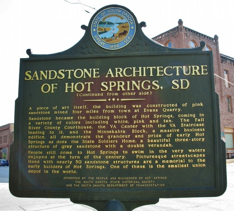
Faulkton, population about 800, is the county seat of Faulk County. The county is 1,008 square miles and was named for Territorial Governor Andrew J. Faulk, hence the name Faulkton.
Pioneers from lowa, led by John A. Pickler, founded the town . . . — — Map (db m205914) HM
You are entering
Roberts County
South Dakota
Long the home of Sisseton, Wahpeton & Cuthead Yanktonaise Sioux, it became part of Deuel & Cheyenne Counties in 1862; Deuel extending N to 46th parallel (4 miles N) in 1872. The Reservation . . . — — Map (db m197534) HM
The town was named for H.E. Bonesteel, early day freighter. Its first postmaster was Francis M. Safeser, 1 August 1892. By 1905 it had 754 people and had made the Big Time Headlines. It came about his way. In 1902 the railroad reached Bonesteel . . . — — Map (db m234830) HM
In the mid-1800s, the United States had a growing appetite for land and natural resources. Wanting to expand across the continent, Congress passed the Donation Land Claim Act in 1850, offering free land to encourage settlement in the Oregon . . . — — Map (db m188301) HM
This building is the Chicago Northwestern Depot built in 1906. This was also the year the railroad was built into Midland. It was purchased by the Midland Pioneer Museum Association in 1974 and moved from its site along the railroad tracks about . . . — — Map (db m124093) HM
(side 1)
In 1889 South Dakota was admitted to the union and western
South Dakota was opened for settlement. The next year surveying was conducted throughout the summer and the town of Midland, named for its location halfway between the . . . — — Map (db m124087) HM
Edgar I. Brown, born in 1854, came here with wife, Alice, and son, Charles, to homestead in the Badlands when he was 55. Their first and only home was a side hill, sod wall, dirt roofed house. About it they built up a humble homestead. Intact today, . . . — — Map (db m45288) HM
In the early 1880s homesteaders immigrated to Dakota Territory settling in this area. They established the villages of Dolph, three miles west, and Poinsett, five miles east. They traveled by foot, oxen or horse-drawn wagons to market products and . . . — — Map (db m206446) HM
Ree Heights Roadside Park
The railroad beat the settlers into this area where farms are giving way to cattle ranches, now as it was then. Ree Heights first postmaster was Wm. H. Love 8 June 1882. Three miles South are the Ree Heights, . . . — — Map (db m185461) HM
The town of Epiphany came into being between the years 1889-1892 and was named by Bishop Martin Marty. In 1893 Father William Kroeger a Catholic priest and medical doctor established the town of “Kroeger”. He built his own laboratory where he made . . . — — Map (db m179876) HM
U.S. Highway 85 Regina, Canada – El Paso, Texas 1588 miles through five states South Belle Fourche • 78 Deadwood • 103 North State Line • 80 Williston, N.D. • 219 Probably the first white men to traverse this area were Wilson Price Hunt and his . . . — — Map (db m231200) HM
Charles L. Hyde devoted much time and energy to promoting the young town of Pierre. A true believer in the city, Hyde built five of the seven buildings in Pierre's historic commercial district along upper Pierre Street. The St. Charles Hotel was his . . . — — Map (db m124294) HM
People have made this area their home for over 10,000 years. In the Paleolithic period, hunters crossed the region hunting ice-age bison and mammoths. Over time, other animals were added to the menu, wild plants became an important food source, and . . . — — Map (db m225023) HM
This rock weighing 14,700 pounds serves as a
memorial to the Mateer Family. The triangle
property upon which it rests was given to the
City of Pierre by Curtis B. and Verna S. Mateer
on March 3, 1964. They later completed it with
sod, . . . — — Map (db m169227) HM
The chapel before you did not always sit here above the dam. The Oahe Mission, which operated the Oahe Industrial School boarding school from 1884 to 1914, was built five miles north on Preoria Bottom. The chapel was used for both worship and as a . . . — — Map (db m170497) HM
Stephen Return Riggs became a Missionary to the Sioux in Minnesota in 1837. Thomas L. Riggs was born in 1847 and twenty-five years later was delegated to serve the Teton Sioux on the Missouri. His first Station, Hope, was west of the Missouri, . . . — — Map (db m178666) HM
Pierre Was a Cowtown (marker side 1)
Yes sir, Mister, Pierre was a cowtown. Why they built the sidewalks two feet off the ground to keep the cows from spattering ‘em up. The stockyards ran longside the river for half a mile and three . . . — — Map (db m124153) HM
This huge structure and its lake, 200 miles long, will cover a multitude of Historic Sites. Oahe is a Dacotah (Sioux) Indian word meaning "Something to stand upon," a foundation, and so it was that in 1875 Thomas L. Riggs, Congregational . . . — — Map (db m112897) HM
The partnership of Registre Loisel and Hugh Heney in 1802 set up a fur post on Cedar Island, within sight, about 5 miles down stream. Loisel was called Little Beaver by the Indians. This was part of Louisiana, receded by Spain to France in 1800 and . . . — — Map (db m219925) HM
This marker commemorates the immigration of the first large groups of Swiss, Low German and Hutterian Brethren from Russia to Dakota Territory.
The first group of fifteen families arrived in Yankton on October 17, 1873. However a . . . — — Map (db m182291) HM
Improved By
City of Parkston
and
Works Progress Administration
Project Number 2974
1938
City Officials
Mayor - W.A. Koehn
Councilmen
M. Hohenthaner
Fred Ceidel
H.K. Meisenhoelder
Edward E. . . . — — Map (db m119555) HM
The prairie town of De Smet was the childhood home of children's book author, Laura Ingalls Wilder. The town was the backdrop for several of Wilder's books. Each July, a live, outdoor pageant is held to depict one of her books. — — Map (db m161869) HM
Water is scarce in the Badlands, which get less than 16 inches of precipitation per year. The bowl-like Cliff Shelf where you stand provides more moisture than commonly found in this desolate land.
Drawn to this spot for more than 11,000 . . . — — Map (db m137125) HM
Mako sica - Lakota
Les mauvaises terres - French
The Badlands - English
When the Lakota looked on the land around you, they saw the Paha ska (white hills)-a place of bountiful hunting. Historically used for . . . — — Map (db m137121) HM
Finding the pass too steep and rough for wagon traffic, homesteaders on the way to Interior parked their rigs at the top—then walked or coaxed their horses down.
How steep is Saddle Pass Trail?
Find out for yourself. Half an hour will . . . — — Map (db m237670) HM
This glacial granite boulder will far outlast all memory of man, I humbly ask of it to be the keeper of my message:
"Thanks for the miracle of life"
I dedicate this in memory of my grandparents, Jefferson and Mary Jane Hand . . . — — Map (db m180806) HM
Cleveland T. Hall is credited by records of historical societies and of the U.S. Department of the Army with carrying the message which saved our nation's capital at the only time it has been seriously threatened by an invasion of enemy forces. . . . — — Map (db m180766) HM
This marks a camp-site of Dakota's first highway 1857, known as Noble's Trail, from Ft. Ridgley, Minn., to the Missouri River.
Also marks the site of Levi Hain's log cabin, erected 1876. — — Map (db m180749) HM
Robert S. Vessey was born near Oshkosh, Wisconsin, May 16, 1858. His father was a minister-farmer with a family of 15 children. He attended common school, but dropped out at an early age to work and assist in the support of his father’s family. He . . . — — Map (db m180805) HM
This indention in the ground is the site of the first home in Jerauld County. Levi Hain and his wife, Maribee began with a sod house in 1876 and soon after built a log cabin. They sold their home and land to Rev. A.B. Smart in 1880 and the cabin . . . — — Map (db m180704) HM
Wood and water were essential to pioneer road builders and in 1857, when the Fort Ridgely & South Pass Wagon Road was built by Col. W.H. Nobles, the springs at Wessington Hills was a natural on the Reconnaissance to the Missouri River. On the . . . — — Map (db m180808) HM
Springs that flow into the park along with an old legend about a trapper named Wessington is how Wessington Springs got its name. Legend has it that Wessington was burned by the Indians while tied to a tree in what is now the city park. Our First . . . — — Map (db m180753) HM
Mighty few towns have one of them hi-faluting, swank Rolls-Royce type of hyphenated names. In 1904, Murdo Mackenzie, head of the Matador brand, with herds from Mexico to Canada, shipped trainload after trainload of Texas steers to Evarts to graze on . . . — — Map (db m134517) HM
Reading Brands
Two old cowpokes reading twenty brands wont agree on all of them but generally speaking this is how to read a brand.
A letter like this (image of backwards letter F) is a reverse F. But this (image of letter F leaning . . . — — Map (db m134569) HM
Home of roving Indians until 1862. The exploring party of Nicollet, scientist, and Fremont, ‘Pathfinder of the West,’ visited Oakwood Lakes July 1838, leaving the first reliable record.
The region East of the Big Sioux was ceded by the Santee . . . — — Map (db m179692) HM
A region of buffaloes and Indians until 1870s. Indian mounds are found at Spirit Lake. In 1838 the Nicollett-Fremont party skirted the NE corner. In 1857 Inkapaduta’s renegade Indians passed through with two white women captives, victims of the . . . — — Map (db m179691) HM
This prairie schooner is a typical wagon that pioneers would have used in the late 1800s. It was a "barn find" in Iowa and was restored by the Hansen Wheel and Wagon Shop in Letcher, SD. Based on the wagon's wear and tear, it was most likely only . . . — — Map (db m209688) HM
Next to Fuller's Hardware was Bradley's Drugstore, run by young George Bradley and his wife, Hattie. Charles Ingalls would often step across the street to exchange stories of the day, tell jokes and maybe play a game of checkers.
George . . . — — Map (db m209679) HM
This is the homestead site of Charles and Caroline Ingalls
and their daughters Mary, Laura, Carrie and Grace
In four of her Little House series of stories of pioneering by the Ingalls and Wilder families, Laura Ingalls Wilder, . . . — — Map (db m209488) HM
As Laura sat sewing, she looked out across Main Street at the Mead Hotel, Wilder Feed Store and Harthorn's Grocery. Clancy's store was across the street in the middle of the northeast side of Main Street.
A census of 1880 does not mention Mr. . . . — — Map (db m209684) HM
Edward H. Couse purchased this lot and the original store building on it from Charles P. Ingalls. By 1885 Couse had succeeded well enough with his hardware business to expand his operation and replace his original wood framed building with a . . . — — Map (db m123916) HM
De Smet Forest Half mile South East of De Smet
De Smet Forest was established by the South Dakota Fish, Game and Parks Department in 1946 and is one of hundreds of small roadside parks now existent or planned along South Dakota highways. At . . . — — Map (db m123917) HM
The first public school of De Smet was built in 1880 by the citizens. They not only furnished the materials but actually did the work. The school house was erected at the corner of Loftus Avenue and Second Street. In later years, it was moved to . . . — — Map (db m209686) HM
Only the pioneers could recall the building that stood at the corner of Calumet Avenue and Third Street. The building dates back to 1880, the first year the town was settled. John A. Owen, pioneer attorney, constructed the building.
John Owen . . . — — Map (db m209678) HM
The Kingsbury County Bank, or Ruth Bank, was organized in 1880 by A. Ruth and Thomas Ruth. In December 1885 it was incorporated under the territorial laws with an authorized capital of $200,000.
Born on March 5, 1844 in Carmichael, . . . — — Map (db m209683) HM
The Laura Ingalls Wilder Memorial Society is happy to welcome your interest in the "Little House" books.
Since 1957, our organization has been busy with the preservation of the Ingalls-Wilder sites and the hosting of Laura's readers. Join us . . . — — Map (db m182747) HM
In the early years of De Smet this building served S.B. Owen as a shoe-making shop and residence for his family. Mrs. Owen was a tailor by trade and taught suit-making to at least one of her children, V.S.L. Owen. He was often mentioned in the files . . . — — Map (db m209682) HM
Thomas P. Powers located his tailor shop in the building between the Loftus Store and Tinkham Furniture. In August of 1886, he sold his business and stock of clothing to Hamilton and Flaata. The following Tuesday night he started for Ireland, his . . . — — Map (db m209681) HM
The Surveyors' House is the oldest building in De Smet, built a year before there was even a town. It was built around 1879 as a railroad company house. Laura Ingalls Wilder wrote in her Little House books of living in this home the first . . . — — Map (db m209685) HM
The original Loftus Store still stands today and was one of the first businesses on Main Street in 1880. Throughout his life as a merchant, Mr. Loftus carried the slogan "The Quality Store" and became known for the quality of goods on the shelves. . . . — — Map (db m209680) HM
The Kingsbury Abstract Company was formed in 1887, with J.C. Gibson, A.W. Miller, C.L. Dawley, Al Thomas and A.N. Waters as members. The company built this building in 1888-89.
Through the years the building has housed many offices, including . . . — — Map (db m123969) HM
On the low hill immediately west of this spot stood the homestead claim shanty of Almanzo and Laura Ingalls Wilder. Mrs. Wilder (1867-1957) is known all over the world as the author of the "Little House" books, a series of autobiographical accounts . . . — — Map (db m182759) HM
Born March 8, 1884, in homestead shanty 3 miles S. ½ mile E. to Thomas and Bersha Dunn, was one of three children. From rural school he entered State College, Brookings, in 1901 to study art under Ada B. Caldwell, of whom he wrote: "She took a . . . — — Map (db m179939) HM
Harvy Dunn
Famed painter and illustrator Harvey Dunn was born on his parents' homestead just south of Manchester on March 8, 1884. He devoted his first 17 years to farm work, schooling, and drawing. By the age of 20, the young Dunn had studied . . . — — Map (db m118677) HM
Imagine a vast plain. Its fertile soil was covered with a blanket of grass and wildflowers swaying in rhythm to what seemed like an eternal wind. The silence of this infinite wilderness gave way to early pioneers who formed a community that . . . — — Map (db m118680) HM
August 27, 1961. More than 150,000 people converged on a patch of land just south of Highway 14 for the Dakota Territory Centennial Goldrush. The event was reminiscent of a stampede caused by General George Custer when he announced that gold had . . . — — Map (db m118679) HM
The Manchester town hall and town pump were two places where everyone gathered. This monument stands on the site of the town hall, which hosted spirited elections, meetings and dances, carnivals and basketball games. The town pump, located in the . . . — — Map (db m162693) HM
You are about to enter
Kingsbury County
A region of buffaloes and Indians until 1870s. Indian mounds are found at Spirit Lake. In 1838 the Nicollet-Fremont party skirted the NE corner. In 1857 Inkepaduta's renegade Indians passed through . . . — — Map (db m179687) HM
Charles B. Kennedy arrived at this location in March 1878. He said, upon his arrival, "There is not a tree in sight, nor sign of human habitation, only paths made by Indians and Buffalo leading to a flowing spring near by." This spring led to his . . . — — Map (db m237341) HM
This log structure was constructed in 1871 for the Herman Luce family. One of the three original homesteaders in this area, Herman Luce contributed to the establishment of Lake County. The log structure housed many families over the years, and . . . — — Map (db m205234) HM
Lake Herman was the original stopping point on the Indian Trail that led from the pipestone quarries in Minnesota to the Three Rivers of the Sioux, a Sioux sanctuary near Fort Thompson on the Missouri. State Highway No. 34 closely follows this . . . — — Map (db m180136) HM
In 2004, Lake Herman State Park received funding from the South Dakota State Historical Society through a Deadwood Fund Grant to restore this structure. Built in 1871, it was originally the home of the Herman Luce family. Through the years it housed . . . — — Map (db m205238) HM
Lars O. and Sonnev Thormodsgaard built this cabin in 1872 near Fairview, SD.
Lars immigrated with brothers Ole and Nils from Hallingdal, Norway, in 1866. Sonnev arrived in 1857. Their nine children were Ingeborg, Emma, Ole, Sissalia, Guri, . . . — — Map (db m205410) HM
In 1877 a group of Swiss chose a point on the shore of Lake Badus for a colony. In 1878 Joseph Burkler, his family and some single men, arrived. In 1879 the colony was augmented by 11 other families who came by rail to Luverne, Minnesota and thence . . . — — Map (db m179686) HM
So named because of its beautiful lakes. It had been the realm of the Dacotah (Sioux) Indians with few white intruders until ceded by the Yankton tribe in 1858. In 1857 the Nobles Trail was built across its NE corner and that year Mrs. Wm. Marble, a . . . — — Map (db m93576) HM
Lake County So named because of its beautiful lakes. It had been the realm of the Dacotah (Sioux) Indians with few white intruders until ceded by the Yankton tribe in 1858. In 1857 the Noble's Trail was built across its NE corner and that year . . . — — Map (db m177453) HM
Dedicated to the pioneers who founded
the Society of Black Hills Pioneers
and made such an outstanding
contribution to the settlement and
development of this highly coveted
region. Their descendants and successors
will forever honor . . . — — Map (db m120999) HM
The view of the Belle Fourche reservoir, Belle Fourche,
and Spearfish has great significance to how
Seth Bullock tied those communities together with
Deadwood.
Belle Fourche Business and
Railroad Train Deals Bullock and Sol . . . — — Map (db m183473) HM
Although the Chinatowns of New York, San Francisco and Chicago are more well-known, these ethnic enclaves weren't exclusive to America's urban centers. There were many Chinatowns in Western boomtowns, including one right here on Deadwood's Lower . . . — — Map (db m120093) HM
Jeff Cleveland settled south of
Deadwood during the spring and
summer of 1876. By the following
year a bustling community was developing around his
property. Named in honor of the pioneer, the mining
camp of Cleveland was called "a populous and . . . — — Map (db m183411) HM
Thousands of people suddenly burst into Deadwood Gulch in 1876. Some came to try their luck at mining; others hoped to strike it rich with supply stores, restaurants and saloons.
"Six weeks ago the site of Deadwood City was a heavy frost of . . . — — Map (db m183181) HM
Note the sites of the county courthouse, the federal building, the depot, the slime plant, and the school. The buildings on Main Street also changed character. Whitewood Creek was partly channelized in 1884, and is covered by a highway. Commercial . . . — — Map (db m183226) HM
Thousands of people suddenly burst into Deadwood Gulch in 1876. Some came to try their luck at mining, while others hoped to strike it rich with supply stores, restaurants, and saloons.
"Six weeks ago the site of Deadwood City was a heavy . . . — — Map (db m183180) HM
By the mid-1890s Deadwood city officials deemed it necessary to purchase a tract of land to be used for recreation and enjoyment by its citizens. Almost fifteen years elapsed before Deadwood's first city park was created. The park surrounding . . . — — Map (db m120232) HM
From 1876 to 1883, Deadwood Gulch contained numerous placer mining operations along Whitewood Creek. Typically, a placer drift mining operation consisted of a vertical shaft excavated down to bedrock. Prospectors then dug a series of horizontal . . . — — Map (db m234698) HM
Extending from the base of
Brown Rocks to the beginning of
present-day lower Main Street,
Elizabethtown was the first of many mining camps
established in Deadwood Gulch during the earliest days
of the gold rush. Named for Elizabeth Card, one of . . . — — Map (db m183219) HM
After gold was discovered in Deadwood Gulch in 1875, commercial buildings were quickly erected on the flat land along Main Street, leaving the hillsides above as the only area for residential development. The first houses in Deadwood were built on . . . — — Map (db m183182) HM
Within twenty years Deadwood changed from mining camp to prosperous Victorian city. Deadwood survived several floods and fires, each time replacing the destroyed wood-framed buildings with stone and brick.
The town acquired some modern . . . — — Map (db m183185) HM
Who the first prospector was -
and when and where gold was
discovered in Deadwood Gulch
is open to question. It is generally
agreed that the Frank Bryant
party found the gold in August
1875 on Whitewood Creek,
probably 100 yards . . . — — Map (db m183191) HM
Placer miners first looked for gold among the gravel and sand in the creek bottoms, such as the one near you. If panning was productive, a group of miners would stake a claim and build a sluice to wash gold from the gravel. Captions: . . . — — Map (db m183190) HM
Deadwood is recognized as the site of the first organized Jewish community in South Dakota. On August 28, 1892, the Hebrew Cemetery Association became the first organization to purchase a section of land in Mount Moriah Cemetery. The section is . . . — — Map (db m218057) HM
Jewish American pioneers significantly contributed to the commercial development and establishment of responsible government in Deadwood. For example, gritty Jewish westerner, Sol Star, arrived in Deadwood in 1876 with his business partner Seth . . . — — Map (db m183220) HM
Prospector Frank McGovern staked his claim on the hillside above you in 1876, then promptly became one of Deadwood's infamous rabble-rousers. After an argument with a grocer in 1878, McGovern was shot in the thighs. During his recovery in the . . . — — Map (db m121058) HM
"Deadwood's Sky Pilot." Henry Weston Smith, was born in Ellington, Connecticut, January 110, 1828. At 23 he became a Methodist exhorter. This led to ordination in the Methodist Episcopal church and he served various communities in New England. In . . . — — Map (db m184295) HM
Near this point in 1875 occurred the second of two initial gold discoveries in the Deadwood area. It was made by the Lardner party of eight prospectors, steered here by John B. Pearson, a man already familiar with Deadwood Gulch. Their "Discovery . . . — — Map (db m185225) HM
Although Deadwood was in a mining district, it didn't remain a mining town. Instead, it became the service center for the Northern Black Hills. Regional residents came to Deadwood for their legal, financial, wholesale, retail and entertainment . . . — — Map (db m36629) HM
In 1877, the first organized Episcopal services were held at the Langrishe Theatre in the mining camp of Deadwood City. From this humble beginning, a determined congregation of men and women established the Protestant Episcopal Society of Deadwood . . . — — Map (db m234771) HM
The "badlands," the lower end of Main Street in front of you, earned its reputation through its saloons, brothels, theaters, gambling halls, and opium houses, which provided rowdy entertainment for the largely male population. Out of this district . . . — — Map (db m183221) HM
Harris Franklin, his wife Anna, and son Nathan arrived in Deadwood, Dakota Territory in 1877. A Jewish immigrant from humble beginnings, Harris Franklin earned his fortune through the wholesale liquor business and gradually diversified into cattle, . . . — — Map (db m183628) HM
As South Deadwood expanded along Sherman Street in early 1876, log cabins and small frame houses appeared on the hillsides above the mining camp. A cemetery was quickly established on a hill deemed too far away from town to ever be developed. Soon . . . — — Map (db m183195) HM
Although the uphill side of Deadwood's Main Street seems like a natural area for development, the neighborhood didn't get its start until the turn of the century, thanks largely to two factors: gunpowder and the stubbornness of Deadwood's first . . . — — Map (db m120997) HM
420 entries matched your criteria. Entries 101 through 200 are listed above. ⊲ Previous 100 — Next 100 ⊳