After filtering for South Carolina, 323 entries match your criteria. Entries 201 through 300 are listed.⊲ Previous 100 — The final 23 ⊳
Cemeteries & Burial Sites Topic
By Ronald Patton, April 25, 2023
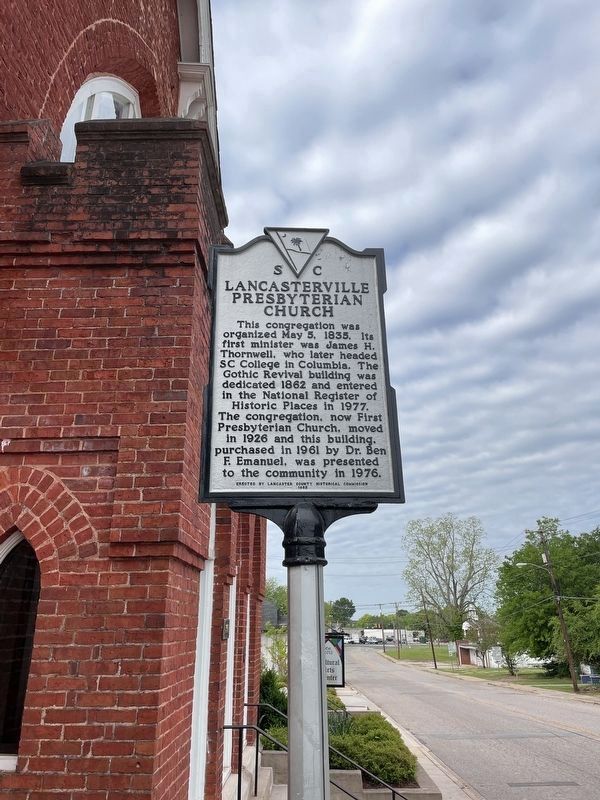
Lancasterville Presbyterian Church Marker (refurbished)
| 201 ► South Carolina, Lancaster County, Lancaster — 29-15 — Lancasterville Presbyterian Church — |
| On West Gay Street, 0.1 miles west of South French Street, on the left when traveling west. | |||
| 202 ► South Carolina, Lancaster County, Lancaster — 29-3 — Waxhaw Presbyterian Church — |
| On Charlotte Highway (U.S. 521) at West North Corner Road, on the right when traveling south on Charlotte Highway. | |||
| 203 ► South Carolina, Lancaster County, Lancaster — 41 — Waxhaw Presbyterian Church Monument — Organized 1755 by Scotch-Irish — American Presbyterian and Reformed Historical Site — |
| On Old Hickory Road, 0.2 miles south of Waxhaw Village Road, on the left when traveling south. | |||
| 204 ► South Carolina, Lancaster County, Midway — 29-20 — Flat Creek Baptist Church — |
| On Old Jefferson Highway at Victory Road, on the right when traveling east on Old Jefferson Highway. | |||
| 205 ► South Carolina, Laurens County, Clinton — 30-3 — Providence Associate Reformed Presbyterian Church — |
| On Ab Jacks Road at U.S. 76, on the right when traveling south on Ab Jacks Road. | |||
| 206 ► South Carolina, Laurens County, Gray Court — 30-15 — Dials Methodist Church — |
| On Saluda Gap Road (State Highway 101) at Dials Church Road, on the right when traveling west on Saluda Gap Road. | |||
| 207 ► South Carolina, Laurens County, Ware Shoals — Mt. Bethel United Methodist Church — Mother of 5 Churches — Bicentennial Anniversary 1768-1972 — |
| On Bethel Church Road. | |||
| 208 ► South Carolina, Lee County, Bishopville — 31-9 — Thomas Gordon McLeod — |
| On West Church Street (State Highway 34) near Roland Street, on the left when traveling west. | |||
| 209 ► South Carolina, Lee County, near Woodrow — Rembert Cemetery — |
| Near Rembert Church Road (State Highway 31-37), on the left when traveling west. | |||
| 210 ► South Carolina, Lee County, near Woodrow — 31-13 — Rembert Church — |
| On Rembert Church Road (State Highway 31-37). | |||
| 211 ► South Carolina, Lee County, South Lynchburg — 31 17 — Lynchburg Presbyterian Church and Cemetery — |
| On Lynchburg Highway (State Highway 341) west of Black Swamp Road (County Road 101), on the right when traveling west. | |||
| 212 ► South Carolina, Lexington County, Batesburg-Leesville — 32-33 — Pinarea / Quattlebaum Sawmill, Flour Mill, and Rifle Factory — |
| On Fairview Road (U.S. 178) at Bagpipe Road, on the right when traveling south on Fairview Road. | |||
| 213 ► South Carolina, Lexington County, Gilbert — 32-31 — Lewie Chapel (Old Gilbert Methodist Church) / The Lewie Family — |
| On Lewie Street (State Highway 32-737) at Waters Ferry Road (State Highway 32-37), on the right when traveling east on Lewie Street. | |||
| 214 ► South Carolina, Lexington County, Lexington — 32-12 — Tomb of Dr. E.L. Hazelius — |
| On West Butler Street near 119 North Church Street, on the right when traveling north. | |||
| 215 ► South Carolina, Lexington County, West Columbia — 32-32 — Saluda Factory Cemetery — |
| On Botanical Parkway near Saluda Mill Drive, on the right when traveling west. | |||
| 216 ► South Carolina, Marion County, Marion — 34-6 — Moody Cemetery — |
| On U.S. 501, 1.5 miles south of State Highway 38, on the right when traveling south. | |||
| 217 ► South Carolina, Marlboro County, Bennettsville — 35-17 — Abel Kolb's Murder / Welsh Neck Cemetery — |
| On U.S. 15 at Kolb's Tomb Road/River Landing Road (County Route 167) when traveling south on U.S. 15. | |||
| 218 ► South Carolina, Marlboro County, Bennettsville — 35-36 — Ammons Family Cemetery — |
| On U.S. 401, on the right when traveling south. | |||
| 219 ► South Carolina, Marlboro County, Bennettsville — 35-5 — Welsh Neck Settlement — |
| On U.S. 15 at Kolb's Tomb Road/River Landing Road (County Road 461), on the left when traveling south on U.S. 15. | |||
| 220 ► South Carolina, Marlboro County, Blenheim — 35-30 — Brownsville Baptist Church — |
| On Old State Highway 38 at Allen Ridge Road (County Road 99), on the left when traveling south on State Highway 38. | |||
| 221 ► South Carolina, Marlboro County, Blenheim — 35-29 — Brownsville Church — |
| On Screw Pin Road (County Road 18) at River Road (County Road 44), on the left when traveling west on Screw Pin Road. | |||
| 222 ► South Carolina, Marlboro County, Blenheim — 35-22 — Frederick Charles Hans Bruno Poellnitz / Ragtown — |
| On State Highway 38, 0.1 miles south of Screw Pin Rd (County Road 18), on the right when traveling south. | |||
| 223 ► South Carolina, Marlboro County, Blenheim — 35-21 — Grave of Mason Lee / Will of Mason Lee — |
| On State Highway 38 at Screw Pin Rd (County Road 18), on the right when traveling south on State Highway 38. | |||
| 224 ► South Carolina, Marlboro County, Blenheim — 35-10 — Robert Blair Campbell / John Campbell — |
| On South Main Street (State Highway 38) at East High Street (State Highway 381) on South Main Street. | |||
| 225 ► South Carolina, Marlboro County, Wallace — 35-8 — John Lyde Wilson — |
| On State Highway 9 at Old Wire Road, on the right when traveling west on State Highway 9. | |||
| 226 ► South Carolina, McCormick County, Bordeaux — 33-5 — Guillebeau Home and Family Cemetery — |
| On State Highway 81 at Moss Avenue (Road 196), on the left when traveling west on State Highway 81. | |||
| 227 ► South Carolina, McCormick County, McCormick — 33-6 — Badwell / Badwell Cemetery — |
| On Savannah River Scenic Byway (State Highway 28) at Barksdale Ferry Road (County Route S-33-61), on the left when traveling west on Savannah River Scenic Byway. | |||
| 228 ► South Carolina, McCormick County, McCormick — Edmunds Family History / Samuel Calhoun Edmunds — |
| On U.S. 378 at Holiday Road (State Highway S-33-7), on the left when traveling west on U.S. 378. | |||
| 229 ► South Carolina, McCormick County, Willington — 33-11 — Cherry Hill / Noble Cemetery — |
| On State Highway 81 at Morrah Bridge Road (County Route 39), on the left when traveling north on State Highway 81. | |||
| 230 ► South Carolina, Newberry County, Maybinton — Ebenezer Methodist Church — 1784-1974 — |
| On State Hwy S 36 81 (State Highway S 36) 0.5 miles south of Maybinton Road, on the right when traveling north. | |||
| 231 ► South Carolina, Newberry County, Newberry — 36-2 — Bush River Quaker Meeting — |
| On Dennis Dairy Road, on the left when traveling north. | |||
| 232 ► South Carolina, Newberry County, Newberry — 36-13 — Calvin Crozier Murder Site — |
| On Nance Street, on the left when traveling south. | |||
| 233 ► South Carolina, Newberry County, Newberry — 36-22 — Newberry Village Cemetery — |
| On Coates Street, on the right when traveling east. | |||
| 234 ► South Carolina, Newberry County, Newberry — 36-25 — Rosemont Cemetery — |
| On College Street just south of North Street, on the right when traveling north. | |||
| 235 ► South Carolina, Newberry County, Pomaria — 36-18 — Bethlehem Lutheran Church — |
| On New Hope Church Road, 0.2 miles north of U.S. 176, on the right when traveling east. | |||
| 236 ► South Carolina, Newberry County, Pomaria — 36-11 — Mount Bethel Academy — United Methodist Church Registered Historic Site No. 419 — |
| On US Highway 176, on the left when traveling south. | |||
| 237 ► South Carolina, Newberry County, Pomaria — Rev. Joachim Bulow. — |
| On Wicker Rd (State Highway 773). | |||
| 238 ► South Carolina, Oconee County, Oakway — Center Methodist Church — Established 1860's — |
| On West Oak Highway (State Highway 24), on the right when traveling north. | |||
| 239 ► South Carolina, Oconee County, Seneca — 37-6 — Capt. Samuel Earle — |
| On SC Highway 59, on the left when traveling south. | |||
| 240 ► South Carolina, Oconee County, Seneca — Memorial Gateway — |
| On North Fairplay Street, on the left when traveling north. | |||
| 241 ► South Carolina, Oconee County, Seneca — Old Pickens Church — Sole Remnant of Town of Pickens |
| On SC Highway 183. Reported missing. | |||
| 242 ► South Carolina, Oconee County, Seneca — Old Pickens Church — Sole Remnant of Town of Pickens Courthouse — |
| Near Old Pickens Church Road near East Pickens Highway (State Highway 183). | |||
| 243 ► South Carolina, Oconee County, Walhalla — Bethel Presbyterian Church — Founded by General Andrew Pickens — |
| On Bethel Church Road (State Road S37-198) just north of Lecroy Road (State Road S37-449), on the left when traveling north. | |||
| 244 ► South Carolina, Orangeburg County, Elloree — Santee~Cemetery — |
| On State Highway 6, on the right when traveling west. | |||
| 245 ► South Carolina, Orangeburg County, Eutawville — 38-7 — Grave of Major Majoribanks / Northampton — |
| On Old Number Six Highway (State Highway 6 / 45) near Fredcon Road, on the left when traveling east. | |||
| 246 ► South Carolina, Orangeburg County, Jamison — 38-16 — Miller Cemetery — |
| On Waterspring Road (State Highway 38-142) near Lime Kiln Road, on the left when traveling east. | |||
| 247 ► South Carolina, Orangeburg County, Orangeburg — 38-22 — Episcopal Church of the Redeemer and Graveyard — |
| On Boulevard Street, NE, on the right when traveling south. | |||
| 248 ► South Carolina, Orangeburg County, Orangeburg — 38-4 — Old Dixie Club Library — |
| On Bull Street (State Road 38-1061), on the right when traveling west. | |||
| 249 ► South Carolina, Orangeburg County, Orangeburg — 38-11 — Pioneer Graveyard — |
| On Bull Street (State Road 38-1061), on the right when traveling west. | |||
| 250 ► South Carolina, Orangeburg County, Providence Community, Holly Hill — 38-35 — Providence Methodist Church — |
| On Old State Road (U.S. 176) near Vance Road (South Carolina Highway 210), on the right when traveling west. | |||
| 251 ► South Carolina, Orangeburg County, Springfield — 38-43 — Rocky Swamp Methodist Church and Cemetery — |
| On Neeses Highway, 0.3 miles east of Kyzer Brown Road, on the right when traveling east. | |||
| 252 ► South Carolina, Pickens County, Clemson — Calhoun Plantation Cemetery — |
| Near South Palmetto Blvd at Williamson Drive. | |||
| 253 ► South Carolina, Pickens County, Clemson — The Old Stone Church — A Frontier House of Worship — |
| On Anderson Highway. | |||
| 254 ► South Carolina, Pickens County, Clemson — The Old Stone Church — The Cemetery — |
| On Anderson Highway. | |||
| 255 ► South Carolina, Pickens County, Clemson — 39-18 — Woodland Cemetery Clemson University / Fort Hill Slave and Convict Cemetery — |
| On Williamson Road just west of Williamson Road, in the median. | |||
| 256 ► South Carolina, Pickens County, Easley — 4 44 — Mt. Pisgah Baptist Church — |
| On Old Greenville Highway (South Carolina Route 88) at Pisgah Road, on the left when traveling west on Old Greenville Highway. | |||
| 257 ► South Carolina, Pickens County, Liberty — Soldiers Buried in Carmel Cemetery — |
| On Carmel Church Road at Lime Drive, on the right when traveling east on Carmel Church Road. | |||
| 258 ► South Carolina, Pickens County, Liberty — St. Luke's Methodist Episcopal Church & Cemetery — |
| On Flat Rock Road north of Anderson Highway (South Carolina Highway 135). | |||
| 259 ► South Carolina, Pickens County, Pumpkintown — Cornelius Keith - 1715-1808 — |
| On Pumpkintown Highway. | |||
| 260 ► South Carolina, Pickens County, Pumpkintown — 39-7 — Oolenoy Baptist Church — |
| On Miracle Hill Road (State Highway 39-298). | |||
| 261 ► South Carolina, Richland County, Blythewood — 40-137 — Sandfield Baptist Church / Sandfield Cemetery — |
| On N. Melton Road, (Sandfield Road) near Russ Brown Road, on the right when traveling east. | |||
| 262 ► South Carolina, Richland County, Columbia — African-American Heroes of the 371st Regiment — |
| Near South Beltline Boulevard at Shop Road (State Highway 768). | |||
| 263 ► South Carolina, Richland County, Columbia, Arsenal Hill — 40-11 — Cemetery of the Columbia Hebrew Benevolent Society — |
| On Gadsden Street at Richland Street, on the left when traveling north on Gadsden Street. | |||
| 264 ► South Carolina, Richland County, Columbia, Arsenal Hill — 40-26 — Entrance to Cemetery of the Columbia Hebrew Benevolent Society — |
| On Gadsden Street, on the right when traveling south. | |||
| 265 ► South Carolina, Richland County, Columbia, Arsenal Hill — Fleishman Family Chapel — |
| Near Blanding Street. | |||
| 266 ► South Carolina, Richland County, Columbia, Cottontown/Belleview — Geiger Ave. Cemetery — |
| On Geiger Avenue at Cardinal Street, on the right when traveling west on Geiger Avenue. | |||
| 267 ► South Carolina, Richland County, Columbia, Earlewood — Confederate Soldiers 1861-1865 — |
| Near Elmwood Avenue. | |||
| 268 ► South Carolina, Richland County, Columbia, Earlewood — Elmwood Cemetery Confederate Soldiers — |
| Near Elmwood Avenue. | |||
| 269 ► South Carolina, Richland County, Columbia, Earlewood — Unknown Confederate Dead Monument — |
| Near Elmwood Avenue. | |||
| 270 ► South Carolina, Richland County, Columbia, Midtown - Downtown — 40-191 — Beth Shalom Cemetery — |
| On Whaley Street at Marion Street on Whaley Street. | |||
| 271 ► South Carolina, Richland County, Columbia, Midtown - Downtown — Cap. Swanson Lunsford — |
| On Assembly Street, on the right when traveling north. | |||
| 272 ► South Carolina, Richland County, Columbia, Midtown - Downtown — 40-22 — First Presbyterian Church — |
| On Marion Street north of Lady Street, on the right when traveling north. | |||
| 273 ► South Carolina, Richland County, Columbia, Midtown - Downtown — 40-106 — Gadsden Street — |
| On Gervais Street at Gadsden Street, on the right when traveling east on Gervais Street. | |||
| 274 ► South Carolina, Richland County, Columbia, Midtown - Downtown — 40-133 — Randolph Cemetery — |
| On Frontage Road, on the right when traveling west. | |||
| 275 ► South Carolina, Richland County, Columbia, Midtown - Downtown — Taylor Burying Ground — |
| On Richland Street near Barnwell Street, on the right when traveling west. | |||
| 276 ► South Carolina, Richland County, Columbia, Midtown - Downtown — 40-51 — Thomas Taylor / Taylor Cemetery — |
| On Richland Street near Barnwell Street, on the right when traveling west. | |||
| 277 ► South Carolina, Richland County, Columbia, Midtown - Downtown — 40-1 — Trinity Episcopal Church — |
| On Sumter Street, on the left when traveling south. | |||
| 278 ► South Carolina, Richland County, Columbia, Midtown - Downtown — Wade Hampton — |
| On Sumter Street at Gervais Street, on the right when traveling north on Sumter Street. | |||
| 279 ► South Carolina, Richland County, Columbia, Olympia-Granby — 40-199 — Olympia Cemetery — |
| On Granby Lane, on the right when traveling south. | |||
| 280 ► South Carolina, Richland County, Gadsden — 40-114 — James H. Adams — |
| On Congaree Road (State Highway 769), on the right when traveling west. | |||
| 281 ► South Carolina, Saluda County, Leesville — Delmar School — |
| On Old Delmar School Road. | |||
| 282 ► South Carolina, Saluda County, Ninety Six — 41-5 — Lucinda Horn — |
| On Chappells Highway (State Highway 39) at Chestnut Hill Road (County Road 135), on the right when traveling south on Chappells Highway. | |||
| 283 ► South Carolina, Saluda County, Ridge Spring — Alexander Hamilton Stevens — 1905-1948 — |
| On Batesburg Road (State Highway 39), on the right when traveling east. | |||
| 284 ► South Carolina, Saluda County, Ridge Spring — 41-11 — Jones Cemetery / General James Jones — |
| On West Main Street (State Highway 23) 0.1 miles west of Saluda Road, on the right when traveling west. | |||
| 285 ► South Carolina, Saluda County, Ridge Spring — 41-12 — Ridge Spring Cemetery / W.H. Scarborough — |
| On Batesburg Road (State Highway 23) at State Highway 41, on the left when traveling west on Batesburg Road. | |||
| 286 ► South Carolina, Saluda County, Saluda — 41-6 — Butler Family Graves — |
| On Butler Church Road, on the right when traveling east. | |||
| 287 ► South Carolina, Saluda County, Saluda — Butler Methodist Church — |
| On Butler Church Road. | |||
| 288 ► South Carolina, Saluda County, Saluda — 41-4 — Luther Rice — (1783-1836) |
| On Newberry Highway at Hollywood School Road (South Carolina Highway 41-44), on the left when traveling north on Newberry Highway. Reported missing. | |||
| 289 ► South Carolina, Saluda County, Saluda — Mitchell Hill Advent Christian Chruch — |
| Near Long Road, 2 miles south of Denny Highway (South Carolina Highway 194), on the right when traveling south. | |||
| 290 ► South Carolina, Saluda County, Saluda — 41-1 — Pierce M. Butler / The Palmetto Regiment — |
| On South Main Street. | |||
| 291 ► South Carolina, Saluda County, Saluda — 41-2 — Red Bank Church — |
| On East Church Street, on the left when traveling south. | |||
| 292 ► South Carolina, Saluda County, Ward — 41-9 — Spann Methodist Church / Captain Clinton Ward — |
| On Church Street (State Highway 23) at Church Street, on the left when traveling west on Church Street. | |||
| 293 ► South Carolina, Spartanburg County, Clifton — 42-27 — Clifton Baptist Church / First Baptist Church — |
| On Hawk Hill Road, 0.1 miles south of Cowpens-Clifton Road, on the right when traveling south. | |||
| 294 ► South Carolina, Spartanburg County, Enoree — Captain Shadrach Inman Memorial — |
| Near Horseshoe Falls Road (State Highway S-42-10) 1.4 miles south of State Highway 56, on the left when traveling south. | |||
| 295 ► South Carolina, Spartanburg County, Greer — Hugh Porter & Jane Baily McClimon — First McClimon Family in South Carolina — |
| On Liberty Hill Road (State Highway 7139) at Wadell Road, on the left when traveling south on Liberty Hill Road. | |||
| 296 ► South Carolina, Spartanburg County, Greer — McClimons Memorial — |
| On Liberty Hill Road at Wadell Road, on the left when traveling south on Liberty Hill Road. | |||
| 297 ► South Carolina, Spartanburg County, Inman — Holly Springs Baptist Church — 1804 - 2004 — |
| On Holley Springs Church Road at Hannon Road on Holley Springs Church Road. | |||
| 298 ► South Carolina, Spartanburg County, Inman — 42-20 — Shiloh Methodist Church — United Methodist Church Registered Historic Site No. 138 — |
| Near Blackstock Road (State Highway 40) 0.2 miles north of New Cut Road, on the right when traveling north. | |||
| 299 ► South Carolina, Spartanburg County, Moore — 42-4 — “Kate Barry” — |
| On Stillhouse Road (State Highway 196) at U.S. 221 on Stillhouse Road. | |||
| 300 ► South Carolina, Spartanburg County, Moore — Walnut Grove Plantation — |
| On Stillhouse Road (State Highway 196) at U.S. 221 on Stillhouse Road. | |||
323 entries matched your criteria. Entries 201 through 300 are listed above. ⊲ Previous 100 — The final 23 ⊳