On West Lawrence Avenue at West Lawrence Avenue (State Highway 79), on the left when traveling west on West Lawrence Avenue.
This handsome brick church was completed in 1881. Seven persons organized the congregation in 1851 in nearby Carmel Township. Moving to Charlotte the next year, they held services in the wooden courthouse and in 1856 built the city's first place of . . . — — Map (db m121366) HM
On Mulliken Road at West Gresham Highway, on the right when traveling south on Mulliken Road.
Members of the Gresham United Methodist Church first worshipped in a school and in homes. In 1879 Palmer and Rebecca McDonald gave this site on which to build a church. In order to erect the church, people in the community donated logs, which were . . . — — Map (db m191522) HM
On East Lawrence Avenue (Business Interstate 69) at Washington Street, on the left when traveling west on East Lawrence Avenue.
Side 1
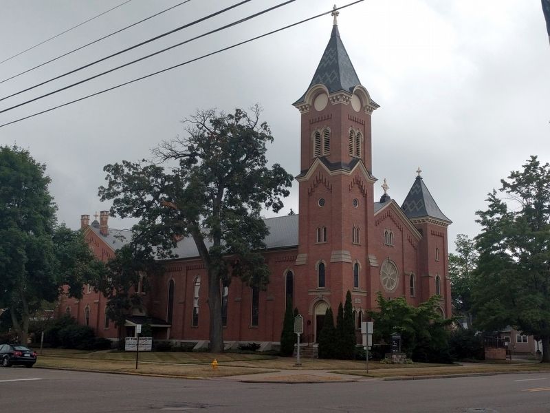
Served for many years by circuit riding ministers, the Methodist congregation dates from 1838, making it Charlotte's oldest religious society. People worshipped at the home of Jonathan Searles, in a temporary courtroom in the Eagle . . . — — Map (db m121387) HM
On Bridge Street near East Quincy Street, on the right when traveling north.
In 1846 Congregational services were conducted by the Reverend Joseph Smith in the home of one of Windsor Township's earliest residents, Nathan Pray. In 1875, nineteen years after the town of Dimondale was platted around the mill of lsaac Dimond, . . . — — Map (db m192247) HM
On Bridge Street at East Quincy Street, on the right when traveling north on Bridge Street.
This bell first called the people of Dimondale to worship in 1882
It was removed from the church tower and displayed here in 1977
In memory of
Clara and Ray Burnett — — Map (db m192493) HM
On West St. Joseph Highway at South Canal Road, on the right when traveling east on West St. Joseph Highway.
In 1837 Methodists in Delta Township began meeting in a log schoolhouse. Served by circuit riders, they organized as a Methodist class in 1842 with two families. The class grew, and in 1865 the Reverend J. Gulic became its first appointed minister. . . . — — Map (db m182783) HM
On College Street at East Street, on the right when traveling west on College Street.
The First Congregational Church grew out of the evangelical movement that swept the country during the early nineteenth century. The congregation and its anti-slavery and temperance societies were organized in 1845. Temperance activities continued . . . — — Map (db m216435) HM
On Vermontville Highway at North Church Street, on the right when traveling west on Vermontville Highway.
Side 1
The Potterville United Methodist Church was organized after the Reverend Hiram Nichols held a revival meeting in Potterville in 1867. The congregation appointed a building committee in 1875 and began work on the church in the spring . . . — — Map (db m125966) HM
On South Main Street at West Main Street, on the right when traveling south on South Main Street.
The Rev. Sylvester Cochrane, a Congregational minister from Vermont, first conceived of a settlement in Michigan after a visit here in 1835. Returning home he formed a group called the Union Colony, which settled in Vermontville the next year. The . . . — — Map (db m191516) HM
On North Main Street at West Main Street, on the right when traveling south on North Main Street.
In 1836 a group from Vermont known as the Union Colony settled here. The members were determined that their children should receive a good education. The Vermontville Academical Association was formed, constructed this building, and opened it for . . . — — Map (db m191517) HM
On North Main Street at East Main Street, on the right when traveling north on North Main Street.
A Methodist class was organized in this area in 1845. Early worship services, held in private homes and local schools, were conducted by preachers traveling the Eaton circuit. In 1859 the Michigan Methodist Conference made Vermontville a separate . . . — — Map (db m191520) HM
Bay View
Bay View comprises one of Michigan's most spectacular collections of Victorian era architecture. Sweeping verandas and stately turrets characterize the Queen Anne style evident in the cottages and public buildings. Planned during . . . — — Map (db m97487) HM
John M. Hall, a young attorney from Flint, was elected as superintendent of the Chautauqua Educational Department of Bay View in 1885. After nearly three decades as superintendent of the Bay View assembly, the Bay View University and . . . — — Map (db m97486) HM
On North Lake Shore Drive at Stone Church Road, on the left when traveling north on North Lake Shore Drive.
1600s - In the mid 1600s, the Jesuit Fathers established an extensive log mission station first below and then here on the bluff. The Odawa called it Ahnamiwatigoning or Prayer Place by the Cross and the French called this settlement La Croix or . . . — — Map (db m229606) HM
On Lake Shore Drive at Stone Church Road, on the right when traveling north on Lake Shore Drive.
The Cross Village Presbyterian Church was first organized on February 19, 1888, and dedicated in October of 1890. In 1918, a fire that destroyed much of the town also consumed the church. The church was rebuilt in 1921 as the results of the . . . — — Map (db m97854) HM
On East Sturgeon Bay Trail just west of Pleasantview Road (County Route C-81), on the left when traveling west.
The congregation of the East
Bliss United Brethren Church
was organized in 1880.
During the pastorate of the
Reverend Edward McFarland,
this Carpenter Gothic style
church was erected. It was
dedicated on May 4, 1903.
The congregation . . . — — Map (db m233803) HM
Ezekiel Solomon, a native of Berlin, Germany, who had served with the British army, arrived at Michilimackinac in the summer of 1761.
He is Michigan’s first known resident of the Jewish faith.
Solomon was one of the most active Mackinac fur . . . — — Map (db m107159) HM
On North Nicolet Street north of East Etherington Street, on the left when traveling north.
Roman Catholicism came to the Straits of Mackinac through the self-sacrificing efforts of seventeenth-century Jesuit Missionaries. In 1670 Father Jacques Marquette established a mission for Huron Indians on Mackinac Island. An . . . — — Map (db m135112) HM
On Lamkin Road, 1.2 miles south of Michigan Highway 119, on the right when traveling south.
Built in 1889...
The church below is the third to stand in the vicinity of the first Jesuit mission in 1741. It was rebuilt by the Indians in 1825 . . . — — Map (db m97791) HM
On Lamkin Road, 1.2 miles south of Michigan Highway 119, on the right when traveling south.
(Side A)
St. Ignatius of Loyola Church and Cemetery
By the 1740s, French Catholic missionaries had come to this area, known to the Odawa as Waganakising, to minister to local tribes. Later, missionary work was taken up by others, including . . . — — Map (db m97790) HM
On State Highway 119, 0.1 miles north of Middle Village Drive, on the left when traveling north.
The church below, built in 1889, stand[s] in the vicinity of the first Jesuit mission of 1741, which was rebuilt by local Waganakising Odawak carpenters and craftsmen in 1825. — — Map (db m97789) HM
On Mitchell Street (County Road 58) east of Petoskey Street, on the right when traveling east.
"We treet you righte both day and night and have no cause for sorrow. Eat your fill and pay your bille and come again tomorrow," was the wording on the sampler that hung in the back of Giles Restaurant for nearly 50 years. In 1929, Enoch Giles Sr. . . . — — Map (db m97989) HM
On South Leroy Street, 0.1 miles south of Silver Lake Road.
In March 1837 the Reverend Washington Jackson formed a Methodist congregation in Dibbleville (present-day Fenton) at the home of Levi Warren. Warren donated land and the first church was built in 1853. Its brick walls collapsed during the . . . — — Map (db m94759) HM
On South Leroy Street at East Elizabeth Street, on the left when traveling south on South Leroy Street.
On May 3, 1858, the Reverend Henry Banwell held Fenton's first Episcopal service for the Ladies Mite Society. The society formally organized as Saint Jude's Episcopal Church on July 18, 1859. In 1860 members built their first church on this site, . . . — — Map (db m94716) HM
On West Dayton Street at Chevrolet Avenue, on the right when traveling west on West Dayton Street.
The Community Presbyterian Church grew out of the Civic Park community, which General Motors established in 1919 through its Modern Housing Corporation to provide housing for its Flint workers. Several Presbyterian families in the area first met in . . . — — Map (db m180449) HM
On West Court Street at West Mitchell Avenue, on the left when traveling west on West Court Street.
In 1834 circuit rider Bradford Frazee held the first Methodist service in Flint. The following year, William Brockway, of the Saginaw Mission, established regular services in Wait Beach’s barroom. In 1836 the class of nine persons organized as the . . . — — Map (db m178345) HM
On West First Avenue at Lyon Street, on the left when traveling west on West First Avenue.
Jacob Smith The first permanent structure erected on this site was probably the trading post built in 1819 by Jacob Smith, the founder of Flint. Fluent in English, French, German and a half dozen Indian languages, Smith represented the Chippewa . . . — — Map (db m179846) HM
On Lippincott Boulevard at McPhail Street, on the right when traveling west on Lippincott Boulevard.
Founded in 1875 and named in memory of Paul Quinn, the fourth bishop of the African Methodist Episcopal Church, Quinn Chapel is the oldest black congregation in Genesee County. This building, dedicated in 1957, is the congregation’s third house of . . . — — Map (db m180988) HM
On East Fifth Avenue at Saginaw Street, on the right when traveling west on East Fifth Avenue.
In 1834 Daniel O’Sullivan, a teacher from Ireland, moved to Flint and began teaching religion to students after school. Together with two traveling priests he convinced Bishop Leferve to build a church in Flint. That church became St. Michael Roman . . . — — Map (db m182515) HM
On Saginaw Street at East 3rd Street, on the right when traveling north on Saginaw Street.
The Reverend Daniel Brown came to this area in 1839 to help form a new Episcopal parish. He became the first rector of St. Paul's in 1840 when it received canonical sanction. The congregation met in a temporary chapel and then in a small church . . . — — Map (db m121202) HM
Near North Bray Road, 0.3 miles north of East Coldwater Road.
Built in 1898, this former Cohoctah Evangelical Church initially served the religious needs of a farming community near Howell, Michigan. Since Michigan lumber was in short supply during the time this church was being built, it was constructed of . . . — — Map (db m225363) HM
On West Mt. Morris Road near Dunham Street, on the right when traveling west.
This structure was completed and dedicated as the Brent Creek Methodist Protestant Church in the fall of 1891. There were sixteen members. The church, which was originally located slightly west of this site, was moved here in 1940. The . . . — — Map (db m180635) HM
On East Main Street at North Hazelton Street, on the right when traveling west on East Main Street.
In 1840, Flushing residents began holding religious services in James Seymour´s sawmill. In 1842 the First Methodist Episcopal Church was organized. As part of the Flint River Circuit, the Methodists were ministered to by circuit riders. In 1846, . . . — — Map (db m180633) HM
On Grand Blanc Road at Grand Boulevard, on the right when traveling east on Grand Blanc Road.
In 1833 eleven people established the First Congregational Church of Grand Blanc. The congregation, which held its early services in homes and, later, schoolhouses built their first house of worship in 1855. They replaced it with this modest red . . . — — Map (db m179796) HM
On Saginaw Road at Edwards Street, on the right when traveling south on Saginaw Road.
As Americans settled the wilderness areas of Michigan, religious services were often the first community concern. Beginning in 1831, traveling preachers visited this area, holding revival and prayer meetings, and starting new congregations. One of . . . — — Map (db m179798) HM
On West Broad Street at Walmer Street, on the left when traveling west on West Broad Street.
The First Presbyterian Society of Linden was founded under the direction of the Reverend Thomas Wright on May 8, 1860. It had eight charter members and was the first religious society to be established in the Village of Linden. The Linden . . . — — Map (db m178167) HM
Preston Bradley Water Wheel Dedicated September 6, 1971
In Commemoration of Dr. Preston Bradley
Born in Linden Michigan Aug 18, 1888
A renowned minister. A Founder of the Izaak Walton League of America, eminent author and international . . . — — Map (db m189662) HM
On East State Street (State Highway 57) at Perry Street, on the left when traveling west on East State Street.
In 1891 the Reverend Daniel Webster Hammond and seven members chartered the Methodist Episcopal Church of Montrose. The next year a church was erected on this site; however, a growing congregation demanded a larger building. The present church was . . . — — Map (db m182293) HM
On Vienna Road (State Highway 57) 0.4 miles west of North McKinley Road, on the left when traveling east.
Montrose Township Cemetery
In 1859 Montrose Township bought three acres of land from John Berry to create a burying ground, which was later expanded. In August of that year, John Pickett Slade, a veteran of the War of 1812, was the first . . . — — Map (db m180510) HM
On East Mt Morris Road at Church Street, on the left when traveling west on East Mt Morris Road.
First United Methodist Church, one of the oldest congregations in Genesee County, began with services held in Lewis Buckingham’s home in 1836. The Reverend Luther D. Whitney, a Flint circuit rider, and nine other people, organized the congregation . . . — — Map (db m179823) HM
On State Street (State Highway 15) at Main Street, on the left when traveling south on State Street.
E. S. Swayze opened a drugstore on this site prior to 1870. When the store burned in 1874, Swayze built this one. Members of the Free Methodist Church used the second-floor meeting hall for services from 1887 to 1890. In 1903 Masonic Lodge #401 and . . . — — Map (db m182516) HM
The first iron mining was done on the Gogebic Range in 1884 and Italian miners soon followed first settling in neighboring Hurley, WI. The majority of Italians were from: Trentino, Piedmont, Venetia, Abruzzo-Molise, Calabria, and Sicily. By 1910 . . . — — Map (db m201420) HM
On Mission Road at Mission School Road, on the right when traveling north on Mission Road.
This building is a replica of the original mission church which was erected in 1839 by the Reverend Peter Dougherty, a Presbyterian missionary, who came here from Mackinaw to establish the first mission in this part of the country. Originally the . . . — — Map (db m98195) HM
On Cass Street at Washington Street, on the right when traveling south on Cass Street.
This plaque is issued by the
Historical Society of Michigan
in recognition of
Central United Methodist Church
Founded in 1858
For more than 150 years of
continuous operation in service
to the people of Michigan
and for contributing . . . — — Map (db m98227) HM
Near Beth El Way, 0.1 miles south of Washington Street.
This simple white frame structure featuring gable roof ends with spindle work is the oldest synagogue building in continuous use in Michigan. It was constructed in 1885 on land donated by Perry Hannah, Traverse City lumber magnate who contributed to . . . — — Map (db m168177) HM
On South Oak Street at East 5th St, on the right when traveling south on South Oak Street.
George Fox founded the Religious Society of Friends in England during the seventeenth century. In the U.S. the society, commonly called Quakers, opposed slavery during the nineteenth century, and it opposed war and violence throughout its existence. . . . — — Map (db m168188) HM
This church was incorporated as the First Free Will Baptist Church on November 24, 1855. The congregation met at the Hillsdale College Chapel until the present church was constructed in 1867-68. This Romanesque building was designed by a Chicago . . . — — Map (db m32250) HM
On South Broad Street (State Highway 99) at Cook Street/East Bacon Avenue, on the left when traveling south on South Broad Street.
In 1839 Episcopalians held the first church service in Hillsdale. Saint Peter's Church was organized in 1844. The original Gothic Revival church dates from 1859 and forms the sanctuary of the present church. Saint Peter's housed the first pipe organ . . . — — Map (db m33602) HM
On North Broad Street (State Highway 99), on the left when traveling south.
The origins of Catholicism in Hillsdale County date to the 1840s when Irishmen who worked for the Southern Railroad settled here. In 1853 the Reverend Joseph Kindekens of Adrian and eighty-five people organized St. Anthony's parish. The former . . . — — Map (db m33601) HM
On Griswold Street near Lakeview Court, on the right when traveling north.
In 1849 the Reverend Wilhelm Hattstaedt founded a Lutheran congregation in Hillsdale. It was organized in 1854 under the Reverend Phillip Trautmann as the German Evangelical Lutheran Trinity Church. Construction on this building began in 1854, . . . — — Map (db m220422) HM
On East Chicago Street (U.S. 12) at East Street, on the right when traveling east on East Chicago Street.
William N. Lyster, Irish-born missionary, preached in Jonesville in 1836, and Darius Barker organized the parish in 1838. A church featuring Classical and Gothic styling was begun in 1844 and consecrated by Bishop Samuel McCoskry in 1848. Panelling . . . — — Map (db m32190) HM
On North Chicago at Williams Street, on the right when traveling north on North Chicago.
Twenty charter members, led by the Reverend Elisha Buck, established this church on July 14, 1839. Founded as a Presbyterian mission, it was reorganized under the congregational polity by the Reverend J.J. Bliss in 1844. At first, worship services . . . — — Map (db m63316) HM
On North Street at Winfield Road, on the right when traveling west on North Street.
(Obverse Side)
Mosherville Church
The Mosherville Church was built in 1861-62 on land donated by Joseph and Mary Riggs. Originally part of the Litchfield circuit of the Methodist Episcopal Church, it became the home church of a . . . — — Map (db m66790) HM
On Eighth Street at Oak Street, on the right when traveling south on Eighth Street.
St. Joseph Roman Catholic Church was established in 1889 by Slovenian immigrants who came to the area to work in the mines of the Copper Country. The wood frame church erected by the parish in 1890 was destroyed by fire in 1902. The following year . . . — — Map (db m76302) HM
On Depot Street at Hecla Street, on the right when traveling west on Depot Street.
On March 25, 1890, nine Lutheran congregations, representing 1200 Finnish immigrants, assembled at Trinity Lutheran Church in Calumet and organized the Finnish Evangelical Lutheran Church In America-Suomi Synod. Four pastors and seventeen laymen . . . — — Map (db m201425) HM
On Quincy Street (U.S. 41) at Dakota Street, on the right when traveling west on Quincy Street.
Old Main
Suomi College was founded in 1896 by the Finnish Evangelical Lutheran Church of America. The cornerstone of Old Main, the first building erected at Suomi College, was laid on May 30, 1898. Jacobsville sandstone, quarried at the . . . — — Map (db m122387) HM
On Shelden Avenue (U.S. 41) at Portage Street, on the left when traveling west on Shelden Avenue.
Residents of Houghton found many outlets for social interaction, including membership in a wide variety of clubs and organizations. Some relied on the community of large extended families, while others sought the camaraderie of those with shared . . . — — Map (db m153995) HM
On Isle Royale Street north of East Houghton Avenue, on the left when traveling north.
Methodism had considerable success in Cornwall, an important mining area in southwest England. Cornish miners migrating to the Keweenaw Peninsula during the copper boom of the mid-nineteenth century brought their devotion to Methodism with them. . . . — — Map (db m201429) HM
On East Montezuma Avenue (U.S. 41) 0.1 miles west of Pewabic Street, on the right when traveling east.
Many of the Cornish miners, storekeepers and mining captains who immigrated to this area during the Copper Country mining boom (1842-1860) were Anglicans. On July 17, 1860, the Reverend Samuel A. McCoskry, Episcopal Bishop of Michigan, met with nine . . . — — Map (db m76306) HM
On Main Street (Michigan Route 25) at Riverside Drive, on the right when traveling south on Main Street.
In 1868 the Reverend Manasseh Hickey and twelve settlers organized a Methodist Episcopal church in Caseville. Services were held in a schoolhouse until the present church was built. Upon its dedication on November 15, 1874, the Gothic-inspired . . . — — Map (db m153555) HM
On Water Street near Broad Street, on the left when traveling north.
First Baptist Church
The First Baptist Church began in Rock Falls about 1864 in a building Jeremiah Jenks built as a gathering place. In 1874 the First Baptist Church of Rock Falls was organized with Reverend A. M. Swain. When Mr. Jenks . . . — — Map (db m213486) HM
On Moeller Road, 2.4 miles North Van Dyke Road (State Route 53), on the left when traveling east.
St. Mary of Czestochowa Roman Catholic Church
The Polish refugees who immigrated to Dwight Township in the 1840s in order to escape Prussian domination worshipped at St. Michael’s Catholic Church in Port Austin. In 1903 in an effort to . . . — — Map (db m153627) HM
On East Bay Street, 0.2 miles east of South Beck Street (State Highway 25), on the right when traveling east.
Here, on July 1, 1845, three Lutheran missionaries, Rev. Johann J.F. Auch, Rev. J. Simon Dumser, and Rev. George Sinke, arrived. The Lutheran leader, Rev. Friedrich Schmid, sent them from Ann Arbor to evangelize the Chippewa Indians. A log chapel . . . — — Map (db m131772) HM
Monsignor Jerome V. MacEachin
Affectionately known as Father Mac, the Reverend Monsignor Jerome V. MacEachin (1904-1987) was associated with Lansing area Catholics for nearly 45 years. A native of Ubly, he was ordained in 1932. Father Mac . . . — — Map (db m102974) HM
On Zimmer Road at Haslett Road, on the left when traveling north on Zimmer Road.
The Williamston Center United Methodist Church is the out-growth of a Methodist class that met in a local schoolhouse before this structure was completed. On November 5, 1877, members of the congregation pledged money to build this church. Merrit . . . — — Map (db m106405) HM
The first recorded Methodist meeting in Lansing was held in 1845 when the Reverend Lewis Coburn preached in the log cabin of Joab Page of North Lansing. In 1850 a Methodist class (congregation) was formed in what is now central Lansing. Its first . . . — — Map (db m103630) HM
On E. Michigan Avenue, on the right when traveling west.
Church of the Resurrection On June 15 1922, the Most Reverend Michael J. Gallagher, bishop of Detroit, sent Father John A. Gabriels to Lansing to establish a Catholic parish east of the Pere Marquette railroad tracks that would include East . . . — — Map (db m103656) HM
On North Capitol Avenue at West Kilborn Street, on the right when traveling south on North Capitol Avenue.
Frederick Schmid, pioneer Lutheran
pastor, held the first service in 1853.
Two years later "The First Evangelical
Lutheran Church of Lansing" organized.
It has met on this block ever since.
The present church was built in 1915. — — Map (db m214727) HM
Side A This church, Lansing's first congregation to affiliate nationally (with the Marshall Presbytery), was founded on December 17, 1847. It was organized by the Reverend Calvin Clark, an agent for the American Home Missionary Society. . . . — — Map (db m103502) HM
On South Martin Luther King Boulevard, on the right when traveling north. Reported permanently removed.
Malcolm X, born Malcolm Little in Omaha, Nebraska, in 1925, lived on this site in the 1930's. His early life was marked by the violent death of his father, the Reverend Earl Little, on the Michigan Avenue streetcar tracks. Under severe economic . . . — — Map (db m104016) HM
On César E. Chávez Avenue at North Washington Avenue, on the right when traveling west on César E. Chávez Avenue.
The old church was replaced
with the present structure
in 1916. The current name,
North Presbyterian Church,
was assumed in 1934. — — Map (db m214725) HM
On W. Grand River Avenue at N. Washington Avenue, on the right when traveling west on W. Grand River Avenue.
On October 19, 1863, fourteen members of Lansing’s First Presbyterian Church signed the Articles of Association creating the Franklin Street Church Society. The society acquired a lot for a church from James Turner, a merchant and leading . . . — — Map (db m214726) HM
On Wood Street near East Grand River Avenue, on the right when traveling north.
Congregational churches originated with the Puritan and Separatist churches of New England. Soon after “Michigan” (present-day Lansing) was chosen as the site of the state capital in 1847, the Reverend S. S. Brown, a Congregationalist with the . . . — — Map (db m195625) HM
Side A In 1848, soon after the Michigan legislature relocated the state capital to Lansing Township, an Episcopal society met in the new capitol, located at Washington Avenue and Allegan Street. The society which became a parish in 1856, . . . — — Map (db m103358) HM
On West Holmes Rd. at Averill Dr., on the right when traveling west on West Holmes Rd..
Trinity African Methodist Episcopal Church of Lansing is the oldest black church in the city. Its first services were held in a building on North Washington Avenue. The church formally organized by the Reverend Mr. Henderson of the British . . . — — Map (db m103654) HM
On South Martin Luther King Jr. Boulevard (Michigan Route 99) at Vincent Court, on the right when traveling north on South Martin Luther King Jr. Boulevard.
Little Family Homesite
On this site, in 1930, Earl and Louise Little built the house that was home to Malcolm X and his siblings: Wilfred, Hilda, Philbert, Reginald, Yvonne, Wesley, and Robert. Malcolm was born in Omaha, Nebraska, in 1925. . . . — — Map (db m214849) HM
On East Bellevue Street at Church Street, on the right when traveling west on East Bellevue Street.
On April 12, 1839, eight people met in the Leslie schoolhouse and organized the First Baptist Church. Elijah K. Grout, a charter member, became the church’s first pastor in November 1841. Between 1856 and 1858 this church, the first built in Leslie, . . . — — Map (db m171862) HM
On Catholic Church Road, 0.4 miles east of Williamston Road, on the left when traveling west.
In 1845 local Catholics began holding Mass in the home of Irish immigrant James Markey in Bunker Hill Township. Father Kelly from Ann Arbor traveled on horseback to provide religious services. After the death of a neighbor’s son in 1849, Markey gave . . . — — Map (db m171703) HM
On Marsh Road, 0.3 miles north of Central Park Drive, on the left when traveling north.
Basic education
For children
“Readin’, (w)ritin’, and (a)rithmetic” were the “3 R’s” of pioneer learning. Pioneers rarely had time for more advanced or specialized subjects, such as history or literature. With one teacher for all eight . . . — — Map (db m174994) HM
On Methodist Street east of Okemos Road, on the right when traveling west.
About 1839 Joseph H. Kilbourne settled in this vicinity on land previously occupied by Chief Okemos and several hundred Indians. He became the first postmaster of Sanford (present-day Okemos) in 1840 and served in the Michigan legislature from 1847 . . . — — Map (db m176008) HM
On South Center Street at East Main Street (Michigan Route 106), on the left when traveling south on South Center Street.
This plaque is issued by the
Historical Society of Michigan
in recognition of
First Presbyterian
Church of Stockbridge
founded in 1901
for more than 100 years of
providing continuous service
to the people of Michigan . . . — — Map (db m210485) HM
On North Summit Street at Cherry Street, on the left when traveling north on North Summit Street.
This Century Old Church was organized in 1877 with 72 members as the Methodist Episcopal Church. The building was erected in 1880 on land donated by the Wm. Mcpherson Family. — — Map (db m174722) HM
On Michigan Route 52, 0.1 miles south of Millville Road, on the left when traveling north.
The ministry of the Millville Methodist Church began in 1840. Class meetings were formed and met in the old log school house and in homes. In 1898, the church chartered with 27 members and built the brick church that still serves today Since that . . . — — Map (db m171700) HM
On South Putnam Street at East Middle Street, on the right when traveling north on South Putnam Street.
In July 1896, 101 farmers and teams of horses delivered 219 wagonloads of fieldstone to this site. The farmers participated in the “Great Stone Bee,” a contest to gather and deliver “hard heads” with which to build this Methodist Episcopal Church. . . . — — Map (db m174725) HM
On High Street at North Cedar Street, on the right on High Street.
(Side 1)
Beginning in the 1850s, Williamston Catholics worshipped with visiting priests. They often traveled ten miles by carriage or horseback on rutted, muddy roads to Saint Patrick Church in Woodhull (present-day Shaftsburg) to worship . . . — — Map (db m84588) HM
On Meridian Road, 0.1 miles north of Sherwood Road, on the right when traveling north.
This building was erected about 1887 for John Forster, an early surveyor in the Lake Superior Copper Country. In 1888 the chapel, named in memory of Forster’s daughter Kitty, was presented to the Protestant Episcopal Diocese of Michigan. Simple in . . . — — Map (db m174733) HM
St.John the Baptist Church
Organized in 1855 to serve Irish Catholic immigrants, the parish of St.John the Baptist worshipped in a simple church on the Cowman farm until 1868. That year, the parish of seventy families built this church, which . . . — — Map (db m217492) HM
On West Main Street, on the right when traveling east.
Jonathan Hale and Son was a mill formerly
located at 227 South Steele Street. Hale
operated flour and feed mills in several
other Michigan cities, including Lyons and
Stanton, before opening the Ionia mill in
1901. By 1907, the Ionia mill had . . . — — Map (db m216310) HM
On East Washington Street near Library Court, on the right when traveling west.
In Merritt’s Hall on January 24, 1859, the Reverend Isaac Errett and forty-three members signed the original charter of the Ionia Church of Christ (First Christian Church). The first church of this denomination had been founded in nearby Muir in . . . — — Map (db m215974) HM
On West Washington Street near North Kidd Street, on the right when traveling east.
The St. John’s Episcopal parish was established on February 4, 1841. Under the leadership of the Reverend Melancthon Hoyt, the parish constructed its first church, now the parish house, that same year. Built on land donated by Ionia’s founder, . . . — — Map (db m215973) HM
On West Garden Street at Liberty Street, on the right when traveling west on West Garden Street.
In 1856 the Reverend Isaac Errett organized Disciples of Christ congregations in Montrose- (present-day Muir) and Lyons. Membership grew quickly, and in 1861 this church was built to serve Muir. The board-and-batten Gothic Revival exterior masks a . . . — — Map (db m215375) HM
On West Dwight Avenue at Pearl Street, on the right when traveling west on West Dwight Avenue.
Erected in 1865 A.D. by the pioneer lumberman, Henry Martin Loud, who in that year founded in this area one of the largest lumber operations in Michigan.
The church burned in the fire which destroyed the town of Au Sable and most of the . . . — — Map (db m123971) HM
On East Superior Avenue (State Highway 69) 5.9 miles east of South 5th Street, on the right when traveling east.
July 4th 1661 As a matter of conjecture
Father Menard somewhere along this river either died or
was murdered while on his way
southward from L’Anse to visit the Menominee Indians — — Map (db m125036) HM
On West Vernon Road at North Allen Road, on the right when traveling east on West Vernon Road.
Sherman City.
Sherman City began with a log store
built by E. K. Wood, Giles Gilbert.
and Amos Johnson in 1869 and a
sawmill built in 1870 by John T.
Cahoon. Johnson, Cahoon, and others
platted Sherman City between 1870
and 1873. Both . . . — — Map (db m235334) HM
On East Michigan Street near South Franklin Street, on the left when traveling west.
In 1889, Sacred Heart Academy was organized as a school for St. Charles Church, which was established in 1872. That year a new church was built here and the parish was renamed Most Sacred Heart of Jesus. Father John J. Crowley moved the old church . . . — — Map (db m91751) HM
On West Maple Street at South Washington Street, on the right when traveling west on West Maple Street.
A mission was organized in Mount Pleasant in 1876, and in 1882 the present building was begun. Local businessman William N. Brown contributed most of the building funds, and the bricks and lumber were made in his plants. The interior design of St. . . . — — Map (db m91749) HM
On State Highway 50 at Marshall Street, on the right when traveling south on State Highway 50.
Thirteen lay members founded the First Presbyterian Church of Brooklyn in 1838. The Reverend C.W. Gurney became the church's first installed pastor in 1841. Dedicatory services for the church were held on October 7, 1845. Built with hand-hewn beams . . . — — Map (db m84885) HM
540 entries matched your criteria. Entries 101 through 200 are listed above. ⊲ Previous 100 — Next 100 ⊳