On East Gale Street east of North Broad Street (State Highway 32), on the left when traveling east.
A Gothic Revival style church built by Hannibal Badham Jr. a member of the famous Edenton Badham family of carpenters. Notable contributors to Edenton's architectural heritage, revere such famous names as Joe Welcome (1774-1859) and three . . . — — Map (db m225361) HM
On East Water Street east of Court Street, on the right when traveling east.
Granite Monument erected September 17, 2017, Honors
Hugh Williamson, son of Scotch-Irish parents, was born 1735. in Nottingham, Pennsylvania. His parents wanted him to become a Presbyterian minister, but his quest for knowledge took him in . . . — — Map (db m225261) HM
On North Broad Street (North Carolina Route 32) just south of Park Avenue, on the left when traveling south.
In December 1962, Dr. Martin Luther King, Jr. visited northeastern North Carolina. Arriving in Elizabeth City, the president of the Southern Christian Leadership Conference spoke at African American churches there and in Hertford en route to Chowan . . . — — Map (db m224286) HM
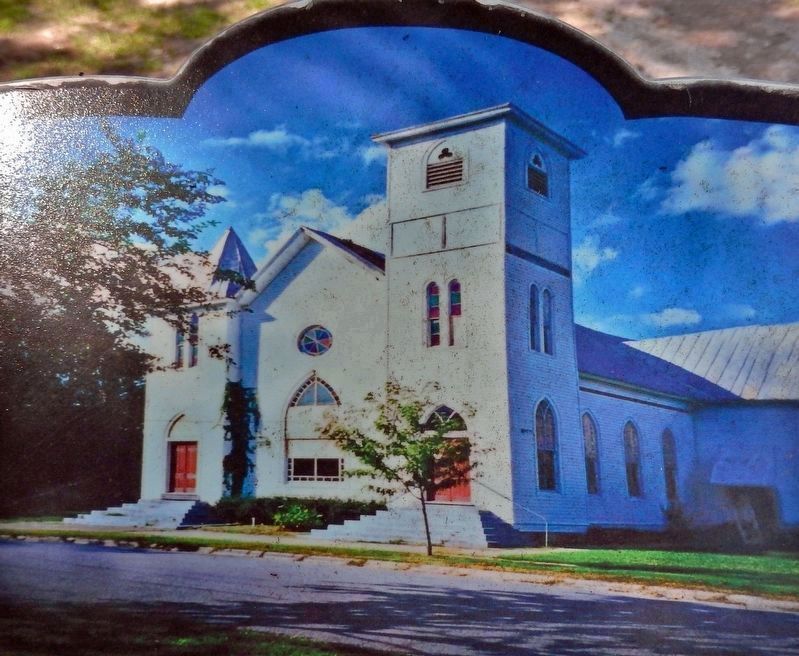
On North Broad Street (State Highway 32) north of East Church Street, on the right when traveling north.
On this site, from 1895 to 1983, stood the new Methodist Church of Edenton. It was a brick structure, a model of elegance and arrangement. The building replaced a wooden church that was located on Eden Street from 1857 to 1895.
Prior to that . . . — — Map (db m57076) HM
On East Water Street just west of Court Street, on the right when traveling west.
[south side]To the Memory of Joseph Hewes April 28, 1730 November 10, 1779[east side]Modestly but without stint he gave his Labor and his Means to the cause of Freedom[north side]Vestryman of St. . . . — — Map (db m225291) HM
On East Church Street (North Carolina Route 32) west of South Oakum Street, on the left when traveling west.
(obverse)
Land purchased 1892, and school founded by lay reader, later ordained 1899, the Revd. William J. Herritage. He and later the Revd. S. Nathaniel Griffith, ordained 1914, served as principals of School and priests of the Mission. . . . — — Map (db m225208) HM
On North Broad Street (State Highway 32) just north of West Church Street, on the left when traveling north.
This building, begun A.D. 1736 and first used in A.D. 1760, is the third church of St. Paul's Parish, Chowan Precinct, Edenton.
The first, A.D. 1701-02, stoode a mile hence on the sound side. It was the first church building in North . . . — — Map (db m175830) HM
On Hiawasee Street (Business U.S. 64) at Pass Street, on the right when traveling north on Hiawasee Street.
Pastor First Baptist Church, Dallas, Texas, 1897-1944, president of Baptist World Alliance. His birthplace stands one mile northwest. — — Map (db m41938) HM
On North Lafayette Street (State Highway 18) just north of Campbell Street, on the right when traveling north.
These Gingko trees are in memory of nine comrades of our church who made the supreme sacrifice in World War II Herbert Branton • George L. Dover • Grady E. Dover • Elvis Hamrick • Earl R. Hicks, Jr. • Elmer Propst • Garnet Tolbert • Hassell Wall • . . . — — Map (db m215396) WM
On East 5th Street (Business U.S. 701) at Pireway Road (North Carolina Highway 904), on the right when traveling south on East 5th Street.
Baptist Church est. here in 1840. Community settled in 1850’s. Railroad terminus located, 1886. Incorporated 1805. Charter changed to Tabor City, 1935. Former “Yam Capital” of the World. — — Map (db m862) HM
Established in 1772 during a visit to New Bern by Rev. Joseph Pilmoor. First known as Andrews Chapel and located Southwest of this site at Hancock St. and Church Alley. Centenary is the oldest continuing Methodist Church South and East of . . . — — Map (db m23743) HM
On Broad Street (Business U.S. 17) at Craven Street, on the right when traveling east on Broad Street.
Episcopal. Craven Parish created 1715. First church erected 1750, this one in 1875. Communion service, given by George II, 1752, still in use. One block S. — — Map (db m76988) HM
On Queen Street at Pasteur Street, on the left when traveling east on Queen Street.
The first African-American Presbyterian Church in the Craven County area founded in 1880, ½ block north of here on Pasteur Street destroyed by the “Great Fire of 1922” rebuilt in 1924 at 720 Bern StreetThe Honorable George H. White, First Clerk of . . . — — Map (db m222495) HM
On Pollock Street at Middle Street, on the right when traveling west on Pollock Street.
The walls on this site are erected over the brick and ballast stone foundation of the first house of worship of Colonial Craven Parish which was established in 1715. The brick Anglican Church was completed in 1750, and it continued in use until the . . . — — Map (db m24354) HM
On New Street at Middle Street, on the right when traveling west on New Street.
Organized in 1817, plaques on the interior walls recognize the thirteen founding members. Built in 1819 - 1821. It is the oldest Presbyterian Sanctuary in continuous use in North Carolina. It is listed in the National Register of Historic Places and . . . — — Map (db m23688) HM
Formally organized on January 6, 1817 in the home of Mrs. Elizabeth Minor, First Presbyterian Church was formed under the leadership of the Rev. John Knox Witherspoon. Included among the charter members were the daughter and granddaughter of the . . . — — Map (db m121985) HM
On Broad Street (U.S. 17) at George Street, on the right when traveling west on Broad Street.
Asst. Superintendent Public Instruction, 1868-70; a founder Livingstone College, 1885; Bishop A.M.E. Zion Church; founded St. Peters, 1864. One blk. N. — — Map (db m24053) HM
On New Street just west of Middle Street, on the right when traveling west.
The Rev. John Knox Witherspoon, A.B., D.D., LL.D., — organizing minister of First Presbyterian Church, New Bern, on January 7, 1817. Born in 1791 at "Pembroke" Plantation on the Trent River, he was the grandson of the Rev. John Witherspoon, the . . . — — Map (db m224026) HM
During the Civil War, thousands of enslaved blacks freed themselves by escaping to Union lines. Craven County native William Henry Singleton (1843-1938) was one of them. According to his biography, Recollections of My Slavery Days (1922), as . . . — — Map (db m24054) HM
1. Cool Spring
Cool Spring is located on the south bank of Cross Creek, which winds its way through downtown Fayetteville. The spring was the primary soucre of water first for Native Americans and subsequently for the European pioneers. It . . . — — Map (db m31149) HM
On Village Drive at Owen Drive, on the right when traveling west on Village Drive.
Bishop of Charleston. He organized Roman Catholics in N.C. at Fayetteville Convention, & consecrated St. Patrick Church, 1829. Present church 4/10 mi. E. — — Map (db m24634) HM
On South MacPherson Church Road near Raeford Road (Business U.S. 401), on the left when traveling south.
Presbyterian. Founded by early Scottish settlers. Graves of Alexander MacPherson and T. H. Holmes, a Confederate general, 1½ miles N. — — Map (db m121984) HM
Muslim slave & scholar. African born, he penned autobiography in Arabic. 1831. Lived in a Bladen County and worshipped with local Presbyterians. — — Map (db m94902) HM
On Village Drive at Bryn Mawr Drive, on the left when traveling east on Village Drive.
First parish to be established under the North Carolina Catholic Church Constitution February 4, 1824. First Catholic Church consecrated in North Carolina March 17, 1829. Original location Bow Street, Fayetteville, North Carolina. — — Map (db m24636) HM
On Ramsey Street (U.S. 401) at East Reeves Bridge Road, on the right when traveling north on Ramsey Street.
One of early Presbyterian ministers in N.C., 1757-1780. Organized Bluff, Barbecue, and Longstreet churches. Grave is 8 mi. east. — — Map (db m42003) HM
On Old Bluff Church Road, 1 mile west of Sisk Culbreth Road, on the right when traveling west.
(Preface):
The Carolinas Campaign began on February 1, 1865, when Union Gen. William T. Sherman led his army north from Savannah, Georgia, after the "March to the Sea." Sherman's objective was to join Gen. Ulysses S. Grant in Virginia to . . . — — Map (db m160940) HM
On Corolla Village Road at Persimmon Street, on the left when traveling north on Corolla Village Road.
Historic Corolla Chapel
In 1885, the Corolla community formed an inter-denominational congregation in Corolla Village and built the original one-room chapel. Circuit-riding preachers were sent to the Village by horse and buggy by way of the . . . — — Map (db m91795) HM
On Caratoke Highway (Route 168) at Courthouse Road (North Carolina Highway 1242) on Caratoke Highway.
Preached first Methodist sermon in colony, 1772, at Currituck Courthouse. Pilmoor Memorial Methodist Church is near the site. About 300 ft. north. — — Map (db m2763) HM
On North Virginia Dare Avenue (U.S. 64/264) at Russel Twiford Road, on the right when traveling west on North Virginia Dare Avenue.
Agent of the American Colonization Society in Liberia, founded the A. M. E. Zion Churches in Albemarle area. His first church, 1865, near here. — — Map (db m9462) HM
On Becks Church Road, 0.2 miles north of Homestead Drive, on the right when traveling north.
The congregation of Beck's Reformed Church was
organized in the year of our Lord, 1787, under
the leadership of the Rev. Mr. Schneider. The
first house of worship was a log structure
located in the proximity of this marker.
53 acres of land . . . — — Map (db m238973) HM
On Becks Church Road, 0.2 miles north of Homestead Drive, on the right when traveling north.
Came to America from
Palatinate, Germany, 1738
Located in North Carolina
1755 to 1760
Took up 1465 acres of
land on “Four Mile-Branch”
A patriotic officer
in the Revolutionary War.
Tories burned his buildings
and stole his . . . — — Map (db m238974) HM WM
On East 1st Street at North Salisbury Street, on the right when traveling west on East 1st Street.
St. Stephen has and continues to serve
the African American community
to eliminate social injustices,
promote civil rights and save souls.
National Historic Registry
August 6. 2021 — — Map (db m239034) HM
On U.S. 70, 0.3 miles south of Shuler Road, on the right when traveling north. Reported missing.
First head of Oxford Orphanage (1873-1884) and Thomasville Baptist Orphanage (Mills Home), president Oxford Female College. Grave 100 yds. S. — — Map (db m222593) HM
In 1827 Joannah Smith bequeathed $600 so her Church could have a pastor. The unparalleled generosity of dedicated Presbyterians Joannah and husband James Smith, enabled Joppa Presbyterian Church, then located at this site, to call the Rev. William . . . — — Map (db m181940) HM
On North Carolina Route 11/903 north of James Sprunt Drive, on the right when traveling north.
Grove Academy, a boarding school for boys, established in 1785 under the control of Grove Presbyterian Church, was located one mile N.W. Rev. James M. Sprunt, for whom James Sprunt Community College is named, was principal at the Academy from . . . — — Map (db m226252) HM
On West Orange Street north of West Parrish Street, on the right when traveling north.
Since 1898, White Rock Baptist Church, St. Joseph A.M.E. Church, Stanford L. Warren Library, Lincoln Hospital, John Avery Boys and Girls Club, North Carolina College, and Durham Public Schools are all connected historically to black businesses on . . . — — Map (db m210739) HM
"Mutt" and Sara Evans were civic, business and faith leaders during Durham's fast-changing, mid-20th century decades. Elected Mayor for a record six terms, Mutt Evans served from 1951 to 1963, holding together a diverse coalition of interests . . . — — Map (db m218170) HM
On East Main Street east of North Queen Street, on the right when traveling west.
Church building designed in the Rural English Gothic style by the noted Boston architect Ralph Adams Cram. It stands on the site of the original frame church built in 1880.
Downtown Durham Historic District — — Map (db m126188) HM
On Fayetteville Street north of Formosa Avenue, on the right when traveling south.
Holy Cross Church, established in Durham in 1939 by the Maryland Province of the Society of Jesus, was among North Carolina's earliest African-American Catholic congregations. A rectory was built in 1942 with one room serving as the chapel, and this . . . — — Map (db m218218) HM
On North Buchanan Boulevard at 16 Alley, on the left when traveling south on North Buchanan Boulevard.
Historic Preservation
Society of Durham
The King's
Daughters Home
1925
Designed by Milburn, Heister & Co. for the Sheltering Home Circle of the King's Daughters, this home for older women replaced an earlier frame . . . — — Map (db m232561) HM
On Carroll Street north of Morehead Avenue, on the left when traveling north.
[First panel] Pauli Murray: The Crusader
The deep conviction that sustained Pauli Murray's activism
comes alive in her poetry, which served as an outlet for
her anguish, frustrations, hopes and joys. She shared her
dream of freedom . . . — — Map (db m232518) HM
On West Chapel Hill Street at Carroll Street, on the right when traveling west on West Chapel Hill Street.
First African American female Episcopal priest; lawyer, activist, poet, & human rights champion. Wrote Proud Shoes, 1956. Childhood home ¼ mi. S. — — Map (db m232536) HM
On West St. James Street near Main Street (Business U.S. 64).
Editor of A.M.E. Zion Church papers; orator; a delegate to Methodist world conference; customs collector of Wilmington. Home stood 3 blks. E. — — Map (db m45347) HM
On East Granville Street near St. David Street, on the right when traveling east.
St. Paul A.M.E. Zion Church was organized
on the fourth Sunday in March 1866 under
the leadership of George C. Caine.
The house of worship was erected on the
corner of St. David and Granville Streets
in 1869.
We are grateful to . . . — — Map (db m46638) HM
"Alpha Chapel — This name has been given the new Chapel midway
between Bethania and Rural Hall. The very name "Alpha" is a significant one;
inasmuch as this is the first step the Bethania congregation has ever taken
in the direction Of . . . — — Map (db m140188) HM
On Bethania Road, 0.1 miles east of Main Street, on the left when traveling west.
First planned Moravian Village in N. Carolina. Colonial and antebellum trade and agricultural center. Only remaining continuous, independent Wachovia Settlement. Contains unique remnants of original medieval style plan where families lived in a . . . — — Map (db m52627) HM
The Moravian Church is a Protestant denomination tracing its roots to the followers of Jan Hus. A Czech priest and reformer, Hus was martyred for his faith in 1415. The Moravians founded a church body dedicated to a simple and devout life. For . . . — — Map (db m140201) HM
On South Stratford Road (U.S. 158) at Bryn Mawr Lane (North Carolina Highway 1115), on the right when traveling east on South Stratford Road.
On Dec. 27, 1752, survey for Moravian settlement began near here. Bishop August Spangenberg led frontier expedition that selected 98,985 acres. — — Map (db m51879) HM
On Concord Church Road, on the right when traveling west.
Founded in 1782. Called Waggoner's Chapel by Bishop Asbury. Present sanctuary built in 1908. Oldest Methodist congregation in Forsyth County, according to Methodists in assembly. — — Map (db m53025) HM
On Lewisville Clemmons Road, on the right when traveling north.
Lewisville Baptist Church was established in 1881. In 1882 on this highest knoll in the Lewisville village, a 40'x60' wooden building with double doors and a stately steeple was built. Following destruction by lightning in 1936, it was replaced with . . . — — Map (db m53022) HM
On Shallowford Road at Lewisville Vienna Road, on the right when traveling east on Shallowford Road.
The church was established in 1878 by Methodists from Brookstown and Sharon. The chief founder, Augustus Eugene Conrad, made plans for the first church, a one room building, and it was dedicated in 1882. It was replaced with a three-story brick . . . — — Map (db m53023) HM
On Shallowford Road, on the right when traveling east.
In 1884 the Forsyth Circuit of the Methodist Church bought this house, known as the Wesley Vogler house, for a parsonage. The Circuit consisted of twelve churches in western Forsyth County. By 1901 the Lewisville Charge had been created and took . . . — — Map (db m53020) HM
On Shallowford Road at Tuscany Drive, on the left when traveling north on Shallowford Road.
New Hope Church is the oldest continuing African Methodist Episcopal Zion Church within the Township of Lewisville. This church is among the oldest AME Zion congregations in Forsyth County. — — Map (db m54288) HM
On Lewisville Vienna Road, on the right when traveling north.
Founded in 1777 as the German Church Beyond Muddy Creek. Named Gerber's Church in 1813. Graveyard and old church site, quarter mile east. Called Shiloh since circa 1860. Present sanctuary built in 1883. Oldest congregation in Lewisville. — — Map (db m53024) HM
On Bethabara Road east of Bethania Station Road, on the right when traveling east.
About Bethabara
A City of Winston-Salem park and National Historic Landmark, Bethabara is the site of the first Moravian settlement in North Carolina. In 1753, fifteen Moravians set out on a long journey down the Great Wagon Road . . . — — Map (db m162106) HM
Near Bethabara Road, on the right when traveling east.
This large two-story log building was the first Moravian Congregation House, or church, in North Carolina. It was begun in 1755 and consecrated in February, 1756. It contained the Gemeinsaal (meeting hall) and living quarters for the Minister's . . . — — Map (db m53518) HM
On Yandkinville Road, on the left when traveling west.
Founded by the Phillip N. Mock family who gave one acre of land for the church. Founding members of the congregation donated timber and labor for the construction of the original, single-room log building. The second building was constructed in . . . — — Map (db m53724) HM
On South Church Street south of East Bank Street, on the right when traveling north.
An enslaved African American named David (also known as Davy) lived in a house built here on Lot 7 in 1835. David was purchased by the Wachovia Administration in 1805, eventually becoming the servant of the Administrator, Rev. Ludwig von . . . — — Map (db m172141) HM
Near 4th Street East at North Dunleith Avenue, on the right when traveling west.
spoke here at Goler Metropolitan A.M.E. Zion Church on Monday Apr. 13, 1964 for the Voter Registration Project of Winston-Salem — — Map (db m239243) HM
Near South Church Street just north of Race Street, on the left when traveling south.
In the opening year of the Civil War, the church behind you (now St. Philips Moravian) was constructed for enslaved and free black Moravians. Its cornerstone was laid on August 24, 1861, and it was consecrated on December 15. It replaced an . . . — — Map (db m172121) HM
On North Chestnut Street just north of East 6th Street, on the right when traveling north.
The Rev. George Washington Holland organized First Baptist Church, the first African-American Baptist church in Winston. On July 23, 1879, the congregation purchased the property on this corner from the United Brethren of Salem, dedicating a wooden . . . — — Map (db m172158) HM
On Bethabara Rd., on the left when traveling north.
The only German Colonial Church with attached living quarters remaining in the United States. Moravian Wachovia tract leader Frederic Marshall designed building. — — Map (db m162109) HM
Near South Church Street just north of Race Street, on the left when traveling south.
Many African Americans sought to have their own homes after Emancipation. Although in Salem white landowners sold a few lots to people of color, Moravian Church leaders, under pressure from residents who feared black encroachment, rejected . . . — — Map (db m172125) HM
On South Church Street just north of East Academy Street, on the right when traveling north.
Home Moravian Church is an active Christian congregation. Our mission statement, "Fulfilling Christ's call to love God, live in community, and serve our neighbor," describes the role of Home Church within its community and the world. The . . . — — Map (db m172137) HM
On South Church Street just north of Race Street, on the right when traveling north.
Archaeologists have located 28 of the graves in the original Parish Graveyard. Rebecca Hill was the last person buried in the Parish Graveyard, prior to the racial segregation of Salem cemeteries in 1816. Rebecca was born on January 23, 1772 and . . . — — Map (db m172104) HM
On Race Street at Church Street South, on the left when traveling west on Race Street.
When George and Mary Catherine Hege move to the house at Lot 101 in 1851, they brought with them at least two enslaved African Americans, including Lewis, who had been born in 1840 at the Hege grist and saw mill outside of Salem. Lewis likely . . . — — Map (db m172101) HM
On N. Chestnut St., 0.1 miles north of E. 7th St., on the left when traveling north.
The congregation of Lloyd Presbyterian Church was formed in the 1870s as part of a national movement by Northern missionaries to establish African-American Presbyterian churches in the South. Lloyd Presbyterian Church's current building was . . . — — Map (db m51974) HM
In 1890, New Bethel Baptist Church was organized by the Reverend George Holland, a minister from Danville, Virginia. The congregation first met in the Trade Street home of John Lee and his wife, Alice Snow Lee. The 25-member congregation later . . . — — Map (db m98783) HM
On South Main Street just south of East Academy Street, on the left when traveling south.
Old Salem Historic District
has been designated a
National Historic Landmark
This district possesses national significance as an exceptional reflection of the culture of German immigrants who established the theocratically . . . — — Map (db m172063) HM
On South Main Street, 0.1 miles East Bank Street, on the right when traveling north.
Though Salem's main pottery shop and kiln were located across the street on Lots 48 and 49, potters fired some of their most innovative work here on Lot 38. Once a vacant lot used for storage by the town's first master potter, Gottfried Aust, Lot . . . — — Map (db m172145) HM
On Race Street at Church Street South, on the left when traveling west on Race Street.
This exhibit represents the partial façade of the Reich-Hege house as it appeared in the mid-1800s. Built in 1830, the house stood until 1922. Archaeological excavations, written records, and photographic evidence have helped clarify the . . . — — Map (db m172102) HM
On Church Street South just north of East Academy Street when traveling north.
This building
is erected to the Glory of the
Triune God and in memory of
Rt. Rev. Edw. Rondthaler, D.D.
Pastor of the Home Church 1877 to 1908
Member of Provincial Elders Conference 1880
President of Provincial Elders . . . — — Map (db m172138) HM
The Moravian Graveyard is still known fondly by the old Germanic name of "God’s Acre" (Gottesacker). This burial ground is characterized by its simplicity and uniformity. As the name implies, this is a field where the bodies are "sown as perishable . . . — — Map (db m54684) HM
On South Main Street near West Bank Street, on the right when traveling south.
The outline on the ground represents the location of the second house in Salem. Completed in 1767, it was known as the "Two-Story House" since it was the first of this height. Its neighbor was the first House (at your right), and like the others . . . — — Map (db m172144) HM
On Holiday Street, 0.1 miles north of Carolina Circle, on the left when traveling north.
Silver Hill, a small, L-shaped 1880s African-American neighborhood of modest houses built by tobacco workers and domestic servants, predated the white subdivision of Buena Vista that developed around it. The community housed approximately 12 . . . — — Map (db m135918) HM
Near West Academy Street west of South Main Street, on the left when traveling west.
The Single Brothers' Diaconie, or business organization, played a major role in the economy of Salem. Their operation was vast, stretching before you to the west, and included the Single Brothers' House (1769) and the large log workshop (1771), . . . — — Map (db m172062) HM
528 entries matched your criteria. Entries 101 through 200 are listed above. ⊲ Previous 100 — Next 100 ⊳