On Front Street (Business U.S. 13) at Back Street (County Route T-1503), on the right when traveling north on Front Street.
who landed at Hunt's Point, Old Plantation Creek, on Easter Sunday 1776 and the same day preached the first Baptist sermon, “At the End of a Horsing Tree.” Opposition of the established church caused him to be deported; but kind . . . — — Map (db m71852) HM
On State Highway T-1502 at Back Street, on the right when traveling south on State Highway T-1502.
The Presbyterian Historical Society of Philadelphia, Pennsylvania erected this monument and dedicated it on May 11, 1908, at Makemie Park on Holder Creek where Francis Makemie is buried at his Pocomoke home. In 1984 the monument was moved here and . . . — — Map (db m7829) HM
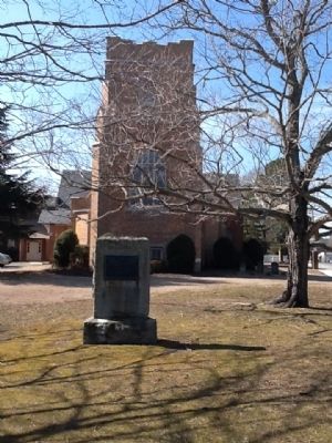
On Atlantic Road (Virginia Route 679) 0.1 miles west of Arbuckle Neck Road, on the left when traveling north.
Fifty yards north on the hilltop stood Assawaman Church of the Anglican Accomack Parish, formed in 1663. The brick sanctuary was built after 1680 on land donated by Willam Taylor, a native of England who had settled on the Eastern Shore by 1637. . . . — — Map (db m205005) HM
Was established on this island on February 14, 1892 by Joseph B. Lynch, not far from this location. Doctrine is Justification and Sanctification. This building was erected in 1903. Since this beginning churches are established throughout the . . . — — Map (db m59834) HM
On Adams Crossing Road at US 13, on the right when traveling east on Adams Crossing Road.
Two miles east, on Route 600, meets what is possibly the nation's oldest continuous Sunday School. Begun by William Elliott in his home in 1785, it was moved in 1816 to Burton's Chapel and in 1870 to the present church. — — Map (db m7615) HM
On West Street at Market Street, on the right when traveling south on West Street.
Built in 1854, Cokesbury Church is the oldest church building in Onancock. Today it serves the community as a venue for religious services, meetings, and concerts. Key events in its history include:
On Market Street, 0.1 miles west of West Street, on the right when traveling west.
Hard by this spot is the site of the home of Francis Makemie the founder of organized Presbyterianism in America who married Naomie Anderson of Accomack County Virginia and established one of his first licensed preaching places here in his Onancock . . . — — Map (db m165101) HM
On St. George Circle just north of Bobtown Road (Virginia Route 178), on the right when traveling west.
St. George's Episcopal
Church
circa 1738
has been placed on the
National
Register of
Historic Places
by the United States
Department of the Interior — — Map (db m165125) HM
On Main Ridge Road at Gabriel Lane, on the left when traveling south on Main Ridge Road.
In 1946, this building served as the first meeting place of the New Testament Congregation. It was vandalized several times during a rather contentious time in the island's religious history, a story reported in Newsweek, 1947.
Throughout the . . . — — Map (db m39682) HM
On Canton Road just south of Canton Road, on the right when traveling south.
This cemetery is the possible site of Lee’s Bethel, the island’s first church. Next to the cemetery is the last of the island’s once plentiful garden farms.
Tangiermen were famous for growing melons, filling their boats until just the gunnels . . . — — Map (db m97873) HM
On Main Ridge Road at Parsonage Lane (Virginia Route T-1310) on Main Ridge Road.
The Methodist Parsonage, the home of the resident Reverend and his family, was erected in 1887. It is the only house on the island with a basement and the first to have an indoor bathroom.
It was the first house to have chain link fence, . . . — — Map (db m39949) HM
On Main Ridge Road at Dise Lane, on the left when traveling south on Main Ridge Road.
The New Testament Congregation was dedicated on Easter Sunday, 1957, and occupies the same site used for the Chautauqua tent in the 1920's.
The New Testament Mission House was once the home of teacher Alfred Benson (1893-1963) who taught at . . . — — Map (db m207732) HM
The most prominent of the island's buildings, Swain Memorial United Methodist Church is easily recognized as the focal point of Tangier.
Built in 1899 on the site of the island's second church (1842), it is the center of the Tangier's religious . . . — — Map (db m39998) HM
On West Ridge Road at School Lane, on the left when traveling north on West Ridge Road.
The Amanda Wallace Pruitt House was also the home of Reverend James C. Richardson after his resignation from the Methodist church.
He founded the New Testament Church, which met here from 1948-1956. Services were held in the living room and . . . — — Map (db m106996) HM
On Main Ridge Road at Williard's Lane, on the right when traveling south on Main Ridge Road.
The Double Six Sandwich Shop is where the watermen meet at 3:00 AM for "smokes and coffee" before heading down to the docks to the day's work.
Named for the game of Dominos, the shop is open for sandwiches year-round, and was often considered . . . — — Map (db m39683) HM
On Main Ridge Road at Twin John Lane, on the right when traveling south on Main Ridge Road.
The Joshua Pruitt House is one of the oldest on Tangier.
Joshua Pruitt (1866-1949) and his wife Amanda took in boarders, teachers, and held worship services in their front yard.
Pruitt traveled to Washington, DC, during the Great . . . — — Map (db m106968) HM
On Main Ridge Road at Pondarosa Road and Twin John Road, on the right when traveling south on Main Ridge Road.
Joshua Thomas (1776–1853) became a skilled waterman
from the in his youth and ferried clergymen
from the mainland to the islands of the
Chesapeake Bay.
He converted to Methodism
about 1807, was licensed as an exhorter (or lay preacher) . . . — — Map (db m97688) HM
On Main Ridge Road at Parks Marina Lane, on the left when traveling south on Main Ridge Road.
For almost 250 years the people of Tangier have wrested a living and a lifestyle from the waters that surround them. Most of their days have been occupied with family, work, church, and the other normal pursuits in which we all engage. But they . . . — — Map (db m106961) HM
Landowner, successful business woman manager, champion of American Independence. Daughter of Naomi and Francis Makemie, founder of organized American Presbyterianism. — — Map (db m7835) HM
On US 13 north of Saxis Road, on the left when traveling north.
Five miles west was the home of the Rev. Francis Makemie, founder of Presbyterianism in the United States. About 1684, Makemie established in Maryland the first Presbyterian Church. Later he moved to Accomac and married. He died here in 1708. — — Map (db m7830) HM
Erected in Gratitude to God And in grateful, remembrance of his servant and minister Francis Makemie, who was born in Ramelton, County Donegal, Ireland, A.D. 1658(?) was educated at Glasgow University, Scotland, and came as an ordained Evangelist to . . . — — Map (db m7838) HM
Welcome to Makemie Monument Park
Designated as A Virginia Historic Landmark September 6, 2006.
And placed on the National Register of Historic Places February 15, 2007. — — Map (db m7833) HM
On Earlysville Road (County Route 743) just south of Advance Mills Road (County Route 663), on the left when traveling north.
Earlysville Union Church is a rare surviving
early-19th-century interdenominational church
constructed in Albemarle County. Built in
1833, this frame structure served as a
meetinghouse for all Christian denominations
on land deeded by John . . . — — Map (db m21650) HM
On Earlysville Road (County Route 743) south of Advance Mills Road (County Route 663), on the right when traveling north.
This tablet placed here by the Colonial Dames of America in the State of Virginia in the year 1930, commemorates the founding of the First Buck Mountain Church established under the authority of The Church of England and builded one mile west of . . . — — Map (db m21690) HM
On James River Road (County Route 626) 0.6 miles east of Chestnut Grove Road (County Route 723), on the right when traveling east.
Shortly after the formation of St. Anne's Parish in 1745, this established church stood on a knoll 100 yards north on nearby Ballenger Creek. Not used regularly after the old parish was dissolved in 1785, the building was in ruins by 1820 and was . . . — — Map (db m29953) HM
On Langhorne Road (County Route 626), on the right.
In 1762 the vestry of St. Anne's Parish purchased from William Burton 400 acres here for the residence and lands of the rector of the parish, established in 1745. This glebe was so used almost until the dissolution of the old parish. It was sold in . . . — — Map (db m29951) HM
On Gordonsville Road (Route 231) 0.1 miles south of Millwood Lane (County Road 783), on the left when traveling south.
The vestry of Fredericksville Parish commissioned a church for this site in 1745. First known as Middle Church, the wood-frame building was later called Walker's Church. Thomas Jefferson attended the nearby classical school of the Rev. James Maury, . . . — — Map (db m170120) HM
On Plank Road (County Route 692) at Monacan Trail Road (U.S. 29), on the right when traveling west on Plank Road.
Named for the community it served. This established church of old St. Anne’s Parish was built on a hill about one half mile east as early as 1769. In 1776 there were plans to build nearby a new, brick church. This new church had not been completed . . . — — Map (db m158048) HM
On East Main Street (Virginia Route 6) east of Valley Street (Virginia Route 20), on the left when traveling east.
Here stands the Barclay House, built about 1830, later the home of Dr. James Turner Barclay, inventor for the U. S. Mint and missionary to Jerusalem. He founded the adjacent Diciples Church in 1846 and served as its first preacher. It is now the . . . — — Map (db m17995) HM
On Holland Lane at Jamieson Avenue, on the right when traveling north on Holland Lane.
[Plaque on the left side of the entrance:]
From the establishment of Alexandria in 1749 to the present time, African Americans have been a vibrant part of this city's history. The City of Alexandria would not exist in its present form were . . . — — Map (db m131547) HM
On King Street (Virginia Route 7) 0.1 miles east of Marlee Way, on the right when traveling east.
Three roads formed this Fairfax County intersection by the early 19th century. Braddock Road, Middle Turnpike (later called Leesburg Pike/King Street/Route 7) and Quaker Lane were the wagon routes for trade between the port town of Alexandria and . . . — — Map (db m150816) HM
On King Street (Virginia Route 7) near South Taylor Street, on the right when traveling east.
Episcopal High School, on the hill to the southwest, was founded in 1839 as a boys' preparatory school, one of the first in the South; girls were admitted in 1991. The school was a pioneer in the establishment of student honor codes in preparatory . . . — — Map (db m7559) HM
On King Street (Virginia Route 7) near South Taylor Street, on the right when traveling east.
Half mile to the southwest. The idea for such an institution was conceived by a group of Alexandria and Washington clergymen in 1818. Among those interested was Francis Scott Key, author of the Star Spangled Banner. Originally at corner of . . . — — Map (db m7561) HM
On King Street (Virginia Route 7) at North Columbus Street, on the left when traveling east on King Street.
Before the American Revolution, the Church of England was the established church of Virginia and part of the colonial government. For administrative purposes, the colony was divided into "parishes" and all residents paid taxes to maintain church . . . — — Map (db m115716) HM
On King Street (Virginia Route 7) at North Washington Street, on the right when traveling east on King Street.
Dr. Bernard Stier, O.D. (1930-2005), practiced optometry at this address from the late 1950s to 1998. Dr. Stier moved his practice here after practicing at 716 King Street with his uncle, Dr. Moses Katz, O.D. (1913-1957). A longtime Alexandrian, Dr. . . . — — Map (db m115717) HM
On South Fairfax Street north of Wolfe Street, on the right when traveling south.
Panel 1 - upper middle of east face:
The First Presbyterian Church of Alexandria founded A.D. 1772 House of worship erected 1774. Destroyed by lightning July 20, 1835. Rebuilt on the same lot A.D. 1836.
Panel 2 - . . . — — Map (db m122164) HM
On King Street (Virginia Route 7) at North West Street, on the right when traveling west on King Street.
The building at 1315 Duke Street, two blocks south of here, was originally built around 1812 as a residence for General Robert Young, commander of Alexandria's militia, who died in 1824. This three-story brick building then became the . . . — — Map (db m115706) HM
On King Street near North St Asaph Street, on the right when traveling west.
George Washington considered Alexandria his hometown after its founding in 1749, and it is here that he came to do business, learn the events of the world, pick up mail, and visit friends. His first association with the town was probably as a 17 . . . — — Map (db m115747) HM
On Wilkes Street east of South Royal Street, in the median.
In 1804, Francois-Dominique Toussaint L'Ouverture, a formerly enslaved Haitian Black military leader, led the only successful uprising of enslaved people in the Western Hemisphere. As a result of the rebellion, the Caribbean island of Haiti . . . — — Map (db m239747) HM
Near North Washington Street near Cameron Street, on the right when traveling south.
Fellow townsmen, brother Masons, trusted friends, comrades in the cause of American Independence.
Col. Charles Simms
Col. Dennis Ramsay
Col. William Payne
Col. George Gilpin
Col. Philip Marsteller
Col. Charles Little
In memory . . . — — Map (db m129193) HM
Near North Columbus Street just south of Cameron Street, on the right when traveling north.
Lieut. Col U.S.A., Revolutionary War
1st Battalion, Lancaster County
Pennsylvania Associators, 1777
Assistant Deputy Quartermaster General
Member of
The Pennsylvania Constitutional Convention, July, 1776
Original stone removed . . . — — Map (db m195645) HM WM
On King Street west of Saint Asaph Street, on the right when traveling east.
The 500 block of King Street has long been associated with retail trade in Alexandria. In the late 18th century, Adam Lynn, Sr. owned the quarter-block at this corner of King and St. Asaph Streets, where he operated a small bake shop selling . . . — — Map (db m115746) HM
On South Royal Street north of Wolfe Street, on the right when traveling north.
Founded 1795
by
Very Rev. Francis Jonatus Neale, S.J.
of Georgetown College
and
Colonel John Fitzgerald, Aide de Camp to General George Washington and one time Mayor of Alexandria
Prior to 1785, the Catholic community of Alexandria . . . — — Map (db m72355) HM
On this site stood Captain Joseph Pugmire and three lassies who conducted the first Salvation Army services in Alexandria. Later, the Salvation Army was located at 319 and 316 King Street from 1922 to 1965, when it moved to its present facility at . . . — — Map (db m143) HM
On Prince Street east of South Columbus Street, on the right when traveling east. Reported permanently removed.
Built in 1802 by Thomas Swann
Purchased in 1832 by
Henry Daingerfield and enlarged.
St. Mary's Academy 1889 - 1943
Restored in 1978 by
Mr. and Mrs. Hugh E. Witt
— — Map (db m134974) HM
On King Street at South Lee Street, on the right when traveling east on King Street.
Home to the Northern Virginia Fine Arts Association, the Athenaeum is a fine example of Greek Revival architecture, with a long and colorful history of occupation. The building was constructed between 1851 and 1852 as the Bank of the Old Dominion, . . . — — Map (db m115768) HM
On George Washington Memorial Parkway north of Prince Street, on the right when traveling north.
In 1804, the Methodist Episcopal congregation of Alexandria moved from its first meeting house in Chapel Alley to this location. The meeting house remained here until 1942, when the building was disassembled and relocated to its present site, where . . . — — Map (db m134972) HM
On Church Street east of South Washington Street, on the right when traveling east.
About eighty feet to the west of this site the original Saint Mary's Church was constructed between 1794–1796 by father Francis Neale, S. J., at the corner of what is now Washington and Church Streets. It was the first catholic church in the . . . — — Map (db m86633) HM
Near Cameron Street east of North Union Street, on the right when traveling east. Reported permanently removed.
Welcome to Old Town Alexandria! Experience historical charm with contemporary flair from the river to the rails
Plan
Alexandria Visitors Center at Ramsay House
Knowledgeable staff help you create a perfect plan for your . . . — — Map (db m167097) HM
On North Columbus Street at Cameron Street on North Columbus Street. Reported permanently removed.
Christ Church embodies God's unbounded love by embracing, liberating, and empowering people—whoever you are and wherever you find yourself on your journey of faith.
An Episcopal church designed by James Wren in the colonial Georgian style . . . — — Map (db m129192) HM
On South Lee Street south of Franklin Street, on the right when traveling north.
A small group of Christian believers established Zion Baptist Church in 1864 on the corner of Wolfe and South Union Streets, northeast of the Wilkes Street Tunnel. At the end of the Civil War, Zion Baptist was one of five African American Baptist . . . — — Map (db m239753) HM
On Wythe Street just east of North Pitt Street, on the right when traveling east.
Populated almost exclusively by Black residents, the racially segregated neighborhood of The Berg evolved by necessity to have its own set of dwellings, amenities, and social institutions. Houses like the "five frame shanties" that stood on this . . . — — Map (db m204836) HM
On North Washington Street (Virginia Route 400) at Oronoco Street, on the right when traveling south on North Washington Street.
Eminent lawyer, he lived here until 1837. His son, Cassius Francis Lee until 1865. Edmund Jennings Lee served as Vestryman and Warden of Christ Church, whose Glebe lands he successfully defended from confiscation after the Revolutionary War. Major . . . — — Map (db m8566) HM
The first story was built in 1812 as the first female free school in Virginia endowed by Mrs. Martha Washington and Mr. W. B. Dandredge.
Potomac Lodge No. 38 of the Independent Order of Odd Fellows purchased the property on November 15, 1841 and . . . — — Map (db m67083) HM
On North Alfred Street south of Princess Street, on the left when traveling north.
The 1990 enlargement of this church is dedicated to God's glory and to the memory of the Afro-American Christians, many of them emancipated slaves, who became the congregation of Meade Church by Action of the vestry of Christ Church in 1873, two . . . — — Map (db m129187) HM
On North Columbus Street at Wythe Street, on the right when traveling north on North Columbus Street.
Under the guidance of the Most Reverend Denis J. O'Connell, Bishop of Richmond, Saint Joseph's Church was built by Father Joseph J. Kelly, of the Society of Saint Joseph (the Josephites) with the assistance of many benefactors, among them being the . . . — — Map (db m129200) HM
On North Washington Street (Virginia Route 400) north of Cameron Street, on the right when traveling south.
On this site stood Beth El Hebrew Congregation’s synagogue, the first structure built as Jewish house of worship in the Washington metropolitan area. Founded in 1859, Beth El, the first reform Jewish congregation in the Washington area, is northern . . . — — Map (db m8604) HM
On Princess Street just east of North Patrick Street (U.S. 1), on the left when traveling east.
Alexandria, occupied by Union troops in 1861, attracted many African Americans escaping slavery. In Jan. 1864, a group of formerly enslaved people organized Third Freedmen's Baptist Church (later Third Baptist Church). The congregation moved to this . . . — — Map (db m140583) HM
On West Braddock Road, 0.2 miles west of Marlboro Drive, on the right when traveling west.
African Americans established "The Fort," a community that continued here after the Civil War (1861-1864) for nearly a century into the Civil Rights Era of the 1960s. The place received its name from The Fort's location around the remnants of . . . — — Map (db m149722) HM
On West Braddock Road, 0.2 miles west of Marlboro Drive, on the right when traveling west.
The Civil War (1861-1865) opened the door for opportunity and civil rights for African American Virginians, about 90 percent of whom were enslaved in 1860. The upheaval from battles and the federal presence in Alexandria and eastern Fairfax . . . — — Map (db m149734) HM
Near West Braddock Road east of North Howard Street, on the right when traveling west.
In 1939, Samuel Javins conveyed the land which was referred to as "Oakland Church lot" nine years earlier, to the Oakland Baptist Church, after the death of his wife, Florence McKnight Javins. She inherited the property from her mother, Harriet . . . — — Map (db m81223) HM
Near West Braddock Road, 0.1 miles west of Marlboro Drive, on the right when traveling west.
Several residents of "The Fort" community were founders of the Oakland Baptist Church, which is located at the intersection of King Street and Braddock Road. The congregation started worshiping in a bush arbor as Oak Hill Baptist Mission in 1888 . . . — — Map (db m81185) HM
On West Street at Duke Street (Virginia Route 236) on West Street.
Text, upper half of marker panel:
This house, built by Emmanuel Jones by 1888, stands at the corner of a block that witnessed the extremes of 19th century African American experience. From a slave trading company to significant . . . — — Map (db m46124) HM
On Alfred Street at Duke Street (Virginia Route 236), on the right when traveling south on Alfred Street.
Alfred Street Baptist Church is home to the oldest
African American congregation in Alexandria,
dating to the early 19th century. It has served as a
prominent religious, educational, and cultural
institution. In 1818, the congregation, then . . . — — Map (db m14623) HM
Near Wilkes Street, 0.1 miles east of Hamilton Avenue, on the right when traveling east.
Henry A. Crump 60th Inf • William M. David 62nd Inf • George W.L. Francis 7th Cav • William H. Haws 8th Inf • George W. Herndon 13th Inf • Elias M. Herring 18th Inf • Elijah F. Hutchison 6th Cav • Edward S. Jett 56th Inf • John J. Knoxville 9th . . . — — Map (db m150721) HM WM
On Wilkes Street, 0.1 miles east of Hamilton Avenue, on the right when traveling east.
Brown, Alexander H. • Carter, Merriwether T. • Darley, William • Jones, George W. • Lawler, John Joseph • Lewis, William L. • Pitts, Henry Segar • Pitts, Robert Tyler • Proctor, John J. • Roland, Richard N. • Sutherland, John W. • Turner, Albert . . . — — Map (db m150723) HM WM
On South Washington Street north of Wolfe Street, on the right when traveling north.
African Americans escaping slavery found refuge in Alexandria after Union troops occupied the city in 1861. The Rev. Clement “Clem” Robinson established the First Select Colored School in 1862. Hundreds of students registered for day and . . . — — Map (db m98079) HM
On Prince Street east of South Fayette Street, on the left when traveling east.
Built 1816-18 by
Capt. James McGuire
Occupied for much of his
Alexandria ministry by
Rev. Samuel Cornelius, Pastor
First Baptist Church, 1824-41
Restored 1964-65 by
Mr. & Mrs. John Page Elliott — — Map (db m66551) HM
Near Wilkes Street, 0.1 miles east of Hamilton Avenue, on the right when traveling east.
Courtesy of Bethel Cemetery,
Est. 1885
on whose grounds rests ten members of Col. John Singleton Mosby's Rangers, 43rd BN CSA. The area of Northern Virginia was known during the war and ever since as Mosby's Confederacy
Ayre, George . . . — — Map (db m150722) HM WM
On South Washington Street (Virginia Route 400) south of Church Street, on the right when traveling north.
This stone taken from the canal of the Potomac Company of which Washington and Fitzgerald were Directors commemorates the erection of the First Catholic Church in Virginia, A. D. 1795, which stood until 1839 about twenty feet behind this . . . — — Map (db m79678) HM
On Hamilton Avenue south of Wilkes Street, on the right when traveling south.
In this cemetery rest the earthly remains of Patriots in the Revolutionary War, many of whom were of Scottish ancestry.
These Patriots, along with many Presbyterians from Alexandria, fought for the cause of Liberty and assisted the Soldiers . . . — — Map (db m129163) HM
On South Washington Street (Virginia Route 400) south of Gibbon Street, on the right when traveling north.
At the end of the 18th century, African Americans constituted half of the congregation at Alexandria's Trinity Methodist Episcopal Church. With support from Trinity, black members founded a separate congregation early in the 1830s, and their . . . — — Map (db m127781) HM
On Duke Street (Virginia Route 236) at South West Street, on the right when traveling west on Duke Street.
Alexandria, occupied by Union troops during the Civil War, became a refuge for African Americans escaping slavery. Before the war ended, about 50 former slaves founded the Shiloh Society, later known as Shiloh Baptist Church. Members held services . . . — — Map (db m91684) HM
On Selma Low Moor Road (Virginia Route 696) 0.2 miles west of Oakland Drive, on the right when traveling west.
During the Civil War, the Jackson River Depot was located here. It marked the western terminus of the Virginia Central Railroad, which extended 200 miles from Hanover Junction north of Richmond. Located just east of the Kanawha Pass of the Allegheny . . . — — Map (db m107980) HM
On Selma Low Moor Road (Virginia Route 696) 0.2 miles west of Oakland Drive (Virginia Route 1002), on the right when traveling west.
First called the Church by the Spring, Oakland Grove Church may have been organized as early as 1834, but it was officially established circa 1847 as a mission of Covington Presbyterian Church. A simple brick house of worship constructed during a . . . — — Map (db m46377) HM
Near Selma Low Moor Road (Virginia Route 696) 0.2 miles west of Oakland Drive (Virginia Route 1002), on the right when traveling west.
In continuous use as a place of worship except for a period between 1861 and 1865 when it was used as a hospital for a contingent of General T.J. (Stonewall) Jackson's troops encamped nearby.
A monument in the churchyard marks the graves of . . . — — Map (db m46379) HM
Near Selma Low Moor Road (Virginia Route 696) 0.2 miles west of Oakland Drive (Virginia Route 1002), on the right when traveling west.
William Henry Haynes, Sr. donated land for the Oakland Church and cemetery in 1811 to trustees James M. Montague, John P. Haynes, David Williamson and William H. Haynes, Jr. But the deed was not recorded until 1859. The original structure is said . . . — — Map (db m46378) HM
Near Selma Low Moor Road (Virginia Route 696) 0.2 miles west of Oakland Drive (Virginia Route 1002), on the right when traveling west.
Jackson River Station
Around 1857, the Virginia Central Railroad completed the Jackson River Depot and was the terminus of the railroad for trains and travelers heading west. Travelers had to continue their travels by horseback or . . . — — Map (db m46385) HM
On Grubb Hill Church Road (Virginia Route 609) 0.4 miles north of Ruffin Lane (Virginia Route 716), on the right when traveling north. Reported permanently removed.
Patriot
Father John Bannister Tabb was born in Amelia County in 1845 at “The Forest”, the Tabb family plantation. A member of one of wealthiest families in Virginia, he was carefully schooled by private tutors until the age of 14, when . . . — — Map (db m35959) HM
Near Grub Hill Church Road (Virginia Route 609) 0.4 miles north of Ruffin Lane (Virginia Route 716), on the right when traveling north.
Tabb was born in 1845 at "The Forest" here in Amelia County into one of Virginia's oldest and wealthiest families, and was destined for the life of a gentleman farmer. The American Civil War changed everything for young John. Despite failing . . . — — Map (db m180255) HM
On Virginia Street (Virginia Route 1009) at Church Street (Virginia Route 1003), on the right when traveling south on Virginia Street.
Amelia County is largely indebted to one woman for bringing formal education and religion to African Americans after the Civil War. In 1865 Mrs. Samantha Jane Neil left her home in Pennsylvania to search for her husband's body. He had been a . . . — — Map (db m180249) HM
On Otterburn Road (Virginia Route 614) 0.1 miles south of Leidig Street (Virginia Route 634), on the right when traveling north.
Russell Grove Presbyterian Church and the Russell Grove School were established as a result of the efforts of Mrs. Samantha Jane Neil, a Presbyterian missionary and teacher of African American children after the Civil War. At first the school . . . — — Map (db m180251) HM
On Mill Quarter Road (County Route 622) at Namozine Road (Route 708), on the left when traveling north on Mill Quarter Road.
When Gen. Robert E. Lee evacuated the Army of Northern Virginia from Petersburg and Richmond on April 2-3, 1865, he ordered the army’s wings to unite at Amelia Court House, where trains would meet them with food and other supplies. The army would . . . — — Map (db m6049) HM
On Kenmore Road (County Route 643) just east of Matohe Road and Father Judge Road (County Route 655), on the left when traveling west.
Bear Mountain is the spiritual center of the
Monacan community. The Bear Mountain Indian
Mission School, ca. 1868, was originally built for
church services and is listed on the National
Register of Historic Places. Virginia’s racial
segregation . . . — — Map (db m104369) HM
On South Amherst Highway (U.S. 29) south of North Coolwell Road (County Route 663), on the right when traveling south.
Nearby stood Rucker’s Chapel, one of the first Anglican (present-day Episcopal) churches in Amherst County. Also known as Harris Creek Church and later as St. Matthew’s, the church was founded by Col. Ambrose Rucker before 1751. It stood on part of . . . — — Map (db m46350) HM
On Patrick Henry Highway (Virginia Route 151) 0.2 miles south of Fletchers Level Road (Virginia Route 610), on the right when traveling north.
To honor
The Reverend Robert Rose
1704-1751
First Minister of St. Ann’s Parish in
Old Albermarle County 1747-1751
This tablet commemorates the establishment
by him of St. Mark’s Church at Maple Run 1748
To the present site, in . . . — — Map (db m122978) HM
On Glebe Road (State Highway 120) at Columbia Pike (State Highway 244) on Glebe Road.
One of the routes at this historic intersection is Glebe Road, developed in the 18-th century to connect Alexandria with northern Arlington. Columbian Turnpike was built in 1808 between the Long Bridge to Washington and the Little River Turnpike at . . . — — Map (db m59705) HM
On South Buchanan Street at 8th Street South, on the right when traveling south on South Buchanan Street.
The Barcroft Community house was constructed in 1908 as a branch chapel of the Methodist church. It was sold in 1914 to the neighborhood civic association, the Barcroft School and Civic League. The building served as the Barcroft neighborhood public . . . — — Map (db m56472) HM
Near Arlington Boulevard (U.S. 50) east of South Pershing Drive, on the right when traveling east.
The Unitarian Church of Arlington (UCA), founded in 1948, had its first permanent home sited here. The first section (on the right) opened in 1949 and the second section in 1952, both designed by UCA member Earl B. Bailey, A.I.A.
Active in the . . . — — Map (db m128220) HM
Near Arlington Boulevard (U.S. 50) west of South George Mason Drive, on the right when traveling east.
Unitarian Universalist Church
of Arlington, Virginia
Sanctuary
1962
Entered in 2014 on the
National Register of Historic Places
United States Department of Interior
Register of Historic Places
Commonwealth of Virginia . . . — — Map (db m128219) HM
On North Glebe Road (Virginia Route 120) just north of Fairfax Drive (Virginia Route 237), on the left when traveling north.
Glebe Road & Ballston
Glebe Road, which passes this site, is one of Northern Virginia's oldest transportation arteries. Its recorded history dates to ca. 1740 when it was known as the "Road to the Falls," taking travelers by land from the . . . — — Map (db m145145) HM
On 6th Street South east of Long Bridge Drive, on the right when traveling east.
" … a detail of men with axes was marched … to the place afterwards known as 'Fort Runyon' and proceeded to level the ground of a fine peach orchard of three hundred trees."
Emmons Clark,
History of the Seventh . . . — — Map (db m134984) HM
On Grant Drive near McClellan Drive, on the left when traveling north.
Left-most, first marker
Catholic Chaplains who
died serving their
country in World War II
and in the Korean and
Vietnam conflicts
World War II
Antonucci, Ralph A. · Babst, Julius J. · Bacigalupo, Andrew · Barrett, Thomas J. · . . . — — Map (db m45149) WM
On Columbia Pike (Virginia Route 244) at Orme Street, on the right when traveling west on Columbia Pike.
Arlington's first house of worship, the Chapel of Ease of Arlington Plantation, was near this location. George Washington Parke Custis built it about 1825 for his family, neighbors, and servants. Services were conducted by students from the . . . — — Map (db m30008) HM
1081 entries matched your criteria. The first 100 are listed above. Next 100 ⊳