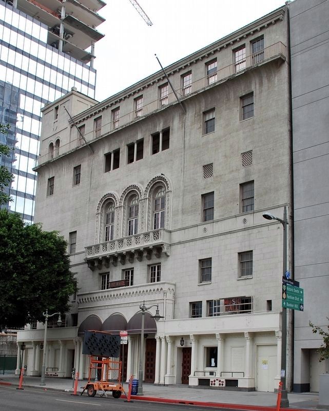
On Figueroa Street south of 9th Street, on the left when traveling south.
Perpetuating the spirit of the cultural
involvement of Los Angeles women.
Declared Historic-Cultural Monument No. 196
by the
Cultural Heritage Board,
Municipal Arts Department,
City of Los Angeles. — — Map (db m175227) HM
On Hermosa Avenue at Colorado Boulevard, on the left when traveling north on Hermosa Avenue.
Eagle Rock Women's Twentieth Century Clubhouse,
Craftsman style,
built 1915. Declared 1991,
Historic-Cultural Monument No. 537,
City of Los Angeles,
Cultural Heritage Commission,
Cultural Affairs Department. — — Map (db m232560) HM
Built 1929, Egyptian Revival style, Westin & Westin, architects. Historic-Cultural Monument No. 462, declared November 3, 1989, City of Los Angeles, Cultural Heritage Commission, Cultural Affairs Department.
American Legion Hollywood Post . . . — — Map (db m170037) HM
On Hollywood Boulevard west of Highland Avenue, on the left when traveling west.
Greek Revival style.
Architect - John C. Austin.
Built 1921. Declared 1984,
Historic-Cultural Monument No. 277,
City of Los Angeles,
Cultural Heritage Commission,
Cultural Affairs Department. — — Map (db m231797) HM
On Hollywood Boulevard west of Highland Avenue, on the left when traveling west.
The Masonic Temple, a Neoclassic Revival design
built in 1921, was the work of John C. Austin, who
also designed L.A. City Hall. The memorial service
for silent film director D.W. Griffith, considered the
father of American movies, was held at . . . — — Map (db m231710) HM
On Lodi Place at Lexington Avenue, on the left when traveling north on Lodi Place.
Mediterranean Revival style.
Architect - Julia Morgan.
Built 1926. Declared 1977,
Historic-Cultural Monument No. 175,
City of Los Angeles,
Cultural Heritage Commission,
Cultural Affairs Department. — — Map (db m175069) HM
On Latimer Road at Haldeman Road, on the left when traveling north on Latimer Road.
Spanish Colonial Revival style.
Architect - William J. Dodd.
Built 1923.
Declared 1999,
Historic-Cultural Landmark No. 663,
City of Los Angeles,
Cultural Heritage Commission,
Cultural Affairs Department.
Landmarked by
the Pacific Palisades . . . — — Map (db m179251) HM
On 28th Street west of Central Avenue, on the left when traveling west.
The YMCA "Colored Branch"
The 28th Street Young Men's Christian
Association (YMCA) of Los Angeles,
also known as the "Colored Branch or
"Colored Y," opened its new building
in November 1926 at the corner of
East 28th Street and . . . — — Map (db m229206) HM
On West Jefferson Boulevard at Royal Street, on the left when traveling west on West Jefferson Boulevard.
A Shrine To Entertainment And Service
When the original Shrine Auditorium opened in 1906, the movies that would make it internationally recognizable were in their infancy; the first dramatic film made entirely in Los Angeles was being . . . — — Map (db m138639) HM
On Monte Vista Avenue at 3rd Street, on the right when traveling north on Monte Vista Avenue.
L.T. Paulson, a local builder, designed the
structure in the English Tudor style. It was
completed in 1929 to serve as the home of
San Dimas Masonic Lodge #428 F & AM. The
building has served many functions and
organizations and has played an . . . — — Map (db m167216) HM
On South Mission Drive north of Santa Anita Street, on the left when traveling north.
This building, built in 1951, was purchased by Ramona Parlor No.109
Native Sons of the Golden West in 1998 and renovated as a meeting
hall and a place to display their early California artifacts in their efforts to preserve the “Spirit of . . . — — Map (db m124459) HM
Near Angeles Crest Highway (California Route 2) at Vincent Gap.
This monument is dedicated to the memory of Lord Baden-Powell of Gilwell, O.M. Founder of Boy Scouting In the year of his 100th anniversary 50th anniversary of world Scouting 47th anniversary of Scouting in America September 1957
Erected . . . — — Map (db m189748) HM
On Grant Avenue at Reichert Avenue, on the right when traveling west on Grant Avenue.
Originally called Loustaunau Hall, erected in 1895, where many organizations held meetings and socials for nearly 100 years. Now hall of Novato Grove Druids No. 113 — — Map (db m102572) HM
On Grant Avenue at Reichert Avenue, on the left when traveling west on Grant Avenue.
In 1890, Dr, H.J. Conradt purchased two lots, where this building now stands, for $10 from the Home and Farm Company. In 1898, when John (Jean) Loustaunau decided to build his own hotel, saloon and restaurant, he and his wife purchased the lots from . . . — — Map (db m102596) HM
Home of San Anselmo American Legion Post 179. Built by the veterans of World War I, Post Ladies Auxiliary, Boy Scout Troops and dedicated community volunteers.
Construction began April 23, 1933 and was completed and dedicated May 27, 1934. . . . — — Map (db m102721) HM
On September 9, 1850 California became a state and the
Coulterville Independent Order of Odd Fellows Lodge
104 was instituted a year later, on October 31, 1851.
Charter members were Samuel A. Scott, George Wilson
Coulter, James Wilson, . . . — — Map (db m241718) HM
On Bear Valley Road (County Road J16) at High Street, on the right when traveling south on Bear Valley Road.
This building was constructed C. 1855 of native schist rock. It was purchased in August 1873 by the Freemasons of Hornitos Lodge No. 98, and since early 1875, continue to meet here. The Lodge was originally chartered as Quartzburg Lodge No. 98 on . . . — — Map (db m46900) HM
On Bear Valley Road (County Road J16) at High Street, on the right when traveling south on Bear Valley Road.
This restored Masonic Hall is recognized for the significant community involvement of its members from 1873 to 1930. The Freemasons owned stores and hotels, served as town and county officials, worked as miners and engineers and supported Hornitos . . . — — Map (db m46899) HM
On Lansing Street near Ukiah Street, on the right when traveling south.
Erik Albertson, first Worshipful Master of Mendocino Lodge No. 179, Free and Accepted Masons, undertook construction of this Masonic Hall in 1866.
Albertson carved "Time and the Maiden," the statue which adorns the roof, out of a single virgin . . . — — Map (db m96627) HM
On North State Street near West Stanley Street, on the right when traveling north.
This wonderful example of Italianate style was built in 1882 and expanded in 1906, adding more offices, a dining room, kitchen and bathrooms.
The Ukiah chapter of IOOF was formed in 1870 and their building was the grandest structure of its . . . — — Map (db m80696) HM
On South School Street near West Perkins Street, on the left when traveling north.
This 1924 Beau Art/classical style building is the second building on this site for the Masons.
Their original 1872 wooden hall burned in 1923. No expense was spared to make this lodge the showcase of Ukiah. The lodge sported a blue Chinese . . . — — Map (db m96480) HM
On Bypass Road at California Route 270, on the right when traveling west on Bypass Road.
During the California gold rush, E Clampus Vitus was a fraternal order and benevolence society for miners. It was rumored to be one of the secret societies in the town of Bodie during its heyday.
Today, ECV is dedicated to the preservation of . . . — — Map (db m8493) HM
Alta Lodge No. 333, Free and Accepted Masons was chartered on October 15. 1897.
The original lodge hall was in the brick building at the corner of Hwy. 395 and Hayes Street. The Lodge moved to this location in 1955. An ever changing society . . . — — Map (db m49958) HM
The American Legion was chartered by Congress in 1919 as a patriotic veterans organization. Focusing on service to veterans, servicemembers, and communities, the Legion evolved from a group of war-weary veterans of World War I into one of the most . . . — — Map (db m143558) HM
On Prescott Avenue at Wave Street on Prescott Avenue.
This simple bronze plaque honoring the work of John Steinbeck was sculptured in 1938 by William Gordon Huff. It was dedicated that same year by noted Western historian Dr. Charles L. Camp with all the unwavering oratorical profundity which . . . — — Map (db m54906) HM
On Coombs Street at 1st Street, on the right when traveling south on Coombs Street.
The Napa Native Sons of the Golden West hall was constructed by the order in 1914. The three story steel-framed brick building is a heritage property and an excellent example of civic properties in Napa. It was the tallest structure in Downtown for . . . — — Map (db m106386) HM
On Spring Street south of Oak Avenue, on the left when traveling south.
The Native Sons of the Golden West Hall has served for more than a century as a gathering place and social center of community activity within St. Helena. It is situated just outside the SW edge of the St. Helena Historic Commercial District, which . . . — — Map (db m55661) HM
On Main Street south of Adams Street, on the right when traveling south.
A fine example of Victorian architecture, this building was erected in 1892 by M. G. Richie. For many years it has served the city’s business community. In 1893 the hall and banquet rooms upstairs were leased to Saint Helena Lodge No. 93 Free & . . . — — Map (db m54543) HM
On South Auburn Street at Bank Street, on the right when traveling south on South Auburn Street.
Madison Lodge #23 was established under dispensation from the Grand Lodge of California on May 4th 1852. Its permanent charter was issued on May 5th 1853. Madison Lodge held its first two meetings at the old Columbus School on the present site of . . . — — Map (db m48685) HM
On North Bloomfield Road at Relief Hill Road, on the left when traveling east on North Bloomfield Road.
This picnic area, sponsored by Wm. Bull Meek-Wm. Morris Steward Chapter Number 10, E Clampus Vitus, is for the enjoyment of all. The redwood lumber for the tables came from Nevada City's Christmas Tree, a Sequoiadendron Giganteum and continues to . . . — — Map (db m857) HM
On North Pine Street east of Commercial Street, on the right when traveling west.
The year was 1850 at a location not far from here. The first Masonic Lodge meeting was held under a Charter from state of Wisconsin. Lafayette Lodge #29 was born, the years following in 1851 & 1863 a major part of which was to be known as Nevada . . . — — Map (db m40272) HM
On North Pine Street at Commercial Street, on the right when traveling west on North Pine Street.
After constructing a second-story meeting hall above two existing 19th century commercial buildings, the Nevada City Benevolent and Protective Order of Elks #518 dedicated its first lodge at this location on June 14, 1913. The lodge hall and . . . — — Map (db m40269) HM
On Nevada Street north of Broad Street, on the right when traveling north.
Home of Ida Colley and niece, Winifred Mulloy, founders of Laurel Parlor #6 Native Daughters of the Golden West. Now Deer Creek Inn Bed & Breakfast. — — Map (db m229296) HM
On Beach Boulevard at 11th Street, on the right when traveling south on Beach Boulevard.
Since its establshment in a newly created Orange County (1889), the Buena Park Woman's Club has influenced the civic life of its community. The club helped establish a volunteer fire department in 1915, a library district in 1919, and the town's . . . — — Map (db m50036) HM
On Harbor Boulevard at Chapman Avenue, on the left when traveling north on Harbor Boulevard.
This property has been placed on the
National Register of Historic Places
by the United States Department of the Interior. Built 1919, rehabilitated 1996.
Plaque placed by Fullerton Heritage.
City of Fullerton Local Landmark No. . . . — — Map (db m235019) HM
On Santa Fe Avenue east of Harbor Boulevard, on the left when traveling east.
Odd Fellows Lodge,
Williams Building,
built 1927,
has been placed on the
National Register
of Historic Places
by the United States
Department of the Interior. — — Map (db m217861) HM
This rustic cabin was erected in 1924 by the Lions Club, local carpenters union and Edison Company as a center for scouting in Huntington Beach and has been in continuous use by Troop 1, Boy Scouts of America, ever since.
The cabin was . . . — — Map (db m59874) HM
Near Newport Center Drive, 0.5 miles east of Jamboree Road.
This monument commemorates the encampment of the Third National Jamboree of the Boy Scouts of America which was held on this site July 1953.
Here is your "locator guide" to find the camping areas of Boy Scouts from each state, territory and . . . — — Map (db m193942) HM
On Center Street south of Chapman Avenue, on the left when traveling south.
Women’s Club of Orange, established 1915.
Old Towne Preservation Association.
This property is within the Old Towne Orange Historic District, placed on the National Register of Historic Places by the United States Department of the . . . — — Map (db m241287) HM
On Court Street, 0.1 miles west of Lincoln Way, on the left when traveling west.
Rebuilt in 1860 after a fire, George Willment resumed his mercantile business on the lower floor of this new fireproof building. The second floor was added at this time which was owned and operated by the Eureka Lodge #16 F&AM. In 1871, Willment . . . — — Map (db m67551) HM
On Commercial Street at Court Street on Commercial Street.
Historical Landmark
Site G. Willment General Store
Second floor was Mason Lodge
Built 1852 – Burned 1855
Rebuilt & Dedicated Dec.,27, 1860
— — Map (db m44075) HM
On Lincoln Way west of Grass Valley Highway (California Highway 49/193), on the right when traveling west.
Instituted in 1852, the first Odd Fellows Lodge organized in Placer County, seventh in California. Meetings were held in several different locations until this building was erected in 1894. Bricks used in construction were made and fired on this . . . — — Map (db m31842) HM
On Commercial Street at Court Street on Commercial Street.
Occupied by Eureka Lodge No. 16 F.A.M.
Much of the material and furnishings came to Auburn via Cape Horn S.A.
This plaque is dedicated to the Pioneers of Auburn by Auburn Parlor No. 232 Native Daughters of the Golden West
June 11, 1933 — — Map (db m44071) HM
On Lincoln Way (California Route 49/193) east of High Street, on the right when traveling east.
The Auburn Masonic Hall was completed in 1917. Since completion it has been home to Eureka Lodge No.16, F. & A. M. The building is clad in beautiful terra cotta manufactured by the Placer County firm of Gladdin McBean. It is the last remaining . . . — — Map (db m31811) HM
On North Main Street, on the right when traveling south.
Free and Accepted Masons
Chartered by Grand Lodge of California
On May 6, 1854 at Illinoistown (about a half mile South of Colfax)
A special Central Pacific train brought the Sacramento Coronet Band and fifty guests for the Dedication of this . . . — — Map (db m45277) HM
On North Main Street, on the right when traveling south.
Independent Order of Odd Fellows
Colfax Lodge No. 132
Instituted 18 April, 1867
This brick building
acquired and used by IOOF
since 26 August, 1889 — — Map (db m45279) HM
Erected in 1864
By International Order of Odd Fellows
Originally 24 feet (front) by 80 feet (along alley)
Two stories high; outside stairway on alley side
expanded east to present size in 1905,
adding four windows and inside stairway . . . — — Map (db m17876) HM
This property - Newcastle Portuguese Hall - has been placed on the National Register of Historic Places by the United States Department of the Interior. — — Map (db m684) HM
On Vernon Street at Lincoln Street, on the left when traveling north on Vernon Street.
Built in 1912, various businesses have occupied this building over the years, including Placer Savings, the Rainbow Club, Schmidt's Delicatessen and Dutra Liquors.
Known as Gordon Hall, the upstairs became a popular gathering place used by . . . — — Map (db m91386) HM
On Main Street at Greeley Street, on the left when traveling east on Main Street.
Originally built in 1875 and twice destroyed by fire, 1898 & 1909, this edifice continues a century of Masonic service to Sierra Valley.
Dedicated in the spirit of brotherhood Sept. 6, 1975 by Las Plumas del Oro Chapter, E Clampus Vitus — — Map (db m56654) HM
On Main Street at Mill Street, on the right when traveling south on Main Street.
This historic building was built in 1878 by John McBeth and D.D. Compton, merchants, for use as a warehouse. As such it played an important role when Greenville’s two foundries, flour mill, sarsaparilla works, brickyard, wagon shop, and sawmill . . . — — Map (db m56648) HM
On Main Street just north of Pike Street, on the right when traveling north.
Originally Burrel-Buckley, barn lot circa 1860, Jumbo Merian’s Grocery & Gas Station, 1930-1945, purchased by Frank C. Reilly, operator from 1945-1965. Frank C. Reilly was the first Humbug of FCR 5978, E Clampus Vitus and one of the very few that . . . — — Map (db m56323) HM
On Main Street east of Cresent Street (California Highway 89 / 70), on the right when traveling west.
Built in 1876, it is one of the first permanent structures in the Quincy Business District. Businesses of this site included Cohn Bros. Dry Goods, U.S. Post Office, I.O.O.F. Lodge, E.C.V. Hall, National Forest Supervisors office, Quincy Hardware and . . . — — Map (db m56386) HM
On West Main Street (State Highway 89 / 70), on the left when traveling east.
Built in 1914 as “Harvey’s Place” by Harvey Egbert. During Prohibition Ed Dory ran the Quincy Dairy Store & some slot machines here. Zola & Plumas “Plumie” Stokes bought the saloon from Egbert in 1947. In 1989 Plumie sold the . . . — — Map (db m56529) HM
On Warhawk Way, on the right when traveling south.
monument front:
Jacqueline Cochran
(1906-1980)
Woman Pilot, Record Setter, WASP, Ninety-Nine
First Woman to Break the Sound Barrier
Charter Member of the Coachella Valley Chapter of Ninety-Nines
Jackie Cochran . . . — — Map (db m114556) HM
Near Sylvan Road, on the right when traveling south.
This property was donated by Adolph and Catherine Van Maren to accommodate this one-room Sylvan School House constructed in 1862 and relocated to this site in 1927. This property was on the northeast side of the former Van Maren Ranch, which covered . . . — — Map (db m46664) HM
On Elk Grove Boulevard, on the right when traveling west.
The first I.O.O.F. meeting was held on
May 2, 1878. The first Rebekah meeting
was held on May 2, 1888. On July 7, 1892
The original building burned and was
rebuilt with the I.O.O.F taking ownership.
A rededication of the hall was
held on March . . . — — Map (db m18031) HM
On Sutter Street, on the right when traveling north.
Site of stables at Western terminus of Pony Express (1860-61), later used by blacksmith shops. Adjacent after 1892 fire, was built two - story Burke's Hall, a community center. Meeting place of Granite Parlor No.83, NSGW (1886-1958).
Dedicated . . . — — Map (db m77653) HM
On Kilgore Road, on the left when traveling north.
Organized March 1874
Dedicated October 1882
Presented by Native Daughters of the Golden West
San Juan Parol #315
Rededicated 5-15-98 — — Map (db m2033) HM
On 7th Street near J Street, on the left when traveling south.
Constructed in 1868. Headquarters of Sacramento Society of California Pioneers Founded 1854 Sacramento Pioneer Foundation Incorporated 1966
Plaque dedicated April 19, 1967 by Sacramento Historic Landmarks Commission Rededicated June 30, . . . — — Map (db m68630) HM
On 7th Street south of J Street, on the left when traveling south.
The Pioneer Hall was built in 1868 as headquarters of the Sacramento Society of California Pioneers, which was organized February 6, 1853. It has been owned and cared for since its construction by the California Pioneer Association, descendants of . . . — — Map (db m68629) HM
First panel:
The Comité Centro Mexicano commemorates the same respect and sense of equality dictated by this historical plaque. With great honor we re-dedicate it in honor of all humanity on this date.
From 1948 to 1975, El Centro . . . — — Map (db m91735) HM
Dr. Duncombe was the first physician on record to come to Sacramento. A Native of Stanford, Connecticut, he moved to Upper Canada (now Ontario) to become a landowner and member of Parliament. Ontario’s first medical school, the Talbot Dyspensary . . . — — Map (db m14105) HM
Born in Cumberland County, Pennsylvania, January 8, 1806, John Bigler was the eldest of what was said to be “a numerous family of children.” As a young man, he was apprenticed to the printing trade and became one of the youngest editors of the . . . — — Map (db m13069) HM
Plot Size: 67” by 68’
Established 1859
In purchasing this site from the Board of Trustees, Sacramento City Cemetery, July 30, 1859, the Order of Free and Accepted Masons became the first fraternal organization in Sacramento to provide . . . — — Map (db m14075) HM
They were an order that inscribed upon their banners, “Visit the sick, relieve the distressed, and bury the dead.”
“To the benevolent – If there is any of that commodity called charity in this community, we earnestly . . . — — Map (db m12489) HM
In 1854 Sacramento was prospering notably in spite of the floods, fires and epidemics that had besieged her. German-born citizens and men of German ancestry decided to organize a “Turn Verein”, as was the custom in their homeland. They . . . — — Map (db m12527) HM
Sacramento City CemeteryThe GRAND ARMY OF THE REPUBLIC Memorial Plot was originally located in the New Helvetia Cemetery at the corner of 31st and J Streets, a plot donated to the Sumner Post No.3 by the owner and proprietor John Wesley Reeves. . . . — — Map (db m12411) HM
On Third Street at Polk Street, on the right when traveling north on Third Street.
Marker One:
Has been placed on the
National Register of Historic Places
By the United States Department of the Interior
1868
Marker Two:
San Juan Bautista
Third Street Historic . . . — — Map (db m225308) HM
On Euclid Avenue (California Route 83) near C Street, in the median.
This fountain was built by the Women's
Christian Temperance Union and dedicated
to this City of Ontario on July 4th 1908, to
provide the town with "a drinking fountain
where only the pure, sparkling water
can be had at any time by the . . . — — Map (db m37513) HM
On Garfield Street, on the left when traveling east.
In 2007, the gazebo had fallen into disrepair and was facing demolition. A group of Carlsbad Hi-Noon Rotarians and community leaders led by L. John Simons, assembled to consider moving and restoring the gazebo. With help from many in the community . . . — — Map (db m117974) HM
Near Garfield Street, on the left when traveling east.
Originally built in the garden behind the Twins Inn. This gazebo was donated to the city of Carlsbad by Neiman’s Village Faire and moved to the Rotary Park in 1950. It was restored through the generous assistance of the Carlsbad Evening Rotary Club. — — Map (db m117957) HM
On West Main Street, on the right when traveling west.
Founder of Knox's Corners,
later the City of El Cajon
Owner of community's first business, the Knox Hotel on the southwest corner of Main and Magnolia; first Postmaster, County roadmaster; charter member of California's International Order of . . . — — Map (db m54383) HM
Built by F.L.Blanc, Parson, Carpenter, Lumberman to store apple box "shook" for drying. When box making failed to pay, he turned it into his first store selling lumber, paint & "A small stock of luxuries." It was used as a rental in the 30's and . . . — — Map (db m84775) HM
Near Midland Road, on the right when traveling south.
Meeting place for the
International Order
of Good Templars
Served as Poway's
first high school
A place for social
and community events
Once was a thrift store and tack
and feed store — — Map (db m74090) HM
On Market Street at 6th Avenue, on the right when traveling west on Market Street.
A joint effort of the Masonic and Odd Fellows Lodges, this Classical Revival-style building required nearly a decade to complete due to a lack of money and materials. A parade kicked off the long awaited laying of the cornerstone, into which was . . . — — Map (db m51620) HM
On Montgomery Street north of Washington Street, on the right when traveling north.
Birthplace of Freemasonry in California.
Historical Landmark No. 408.
second marker:
This site marks the birthplace of
Freemasonry in California.
At this location on October 17, 1849
the first meeting of
Free and . . . — — Map (db m240302) HM
On Washington Street west of Stockton Street, on the left when traveling east.
The first Chinese American troop of
the Boy Scouts of America, Troop
Three of San Francisco, was founded
by eight boys on this Chinese
Methodist Church site in 1914. It is
one of the oldest active troops in the
United States.
Dedicated by . . . — — Map (db m186444) HM
On Pine Street at Kearny Street, on the right when traveling west on Pine Street.
On this site in 1851, Yee Ah Tye established the Sze Yup Company, one of the first
Chinese mutual aid associations in America. Sze Yup Company provided mutual support,
social services and economic aid. Constructed as a temple, the . . . — — Map (db m155185) HM
On Montgomery Street at Commercial Street on Montgomery Street.
“The Family”, one of San Francisco’s oldest and most distinctive social clubs, was founded on this site on April, 1902
This plaque dedicated on the Club’s centennial — — Map (db m58397) HM
On Mission Street at 15th Street, on the right when traveling south on Mission Street.
The Building
Although the building was quickly constructed after the 1906 earthquake, the design does not forgo aesthetics. The post-quake urgency to rebuild is reflected in the building's design; its unusual sheet metal siding was . . . — — Map (db m163003) HM
Near Baker Street just south of Fulton Street, on the right when traveling south.
On September 25, 1886, the Order of the Native Daughters of the Golden West was organized
by Lily O. Reichling-Dyer in Jackson, California. The purpose of the Order is to perpetuate the
principles of love of home, devotion to the flag, . . . — — Map (db m231968) HM
On Baker Street near Fulton Street, on the left when traveling north.
The Order of the Native Daughters of the Golden West was founded on September 25, 1886. In 1899, a Home was established providing our members with "...rest, serenity and an abiding place of affection..."
This structure is our fourth Home in . . . — — Map (db m143240) HM
Founded 1855
B'nai Brith was one of the most vibrant Jewish institutions in San Francisco. It operated seven lodges by 1900. Regional headquarters on this site once housed an extensive library especially strong in Judaica. The Building was . . . — — Map (db m91511) HM
On Mason Street at Geary Street, on the right when traveling north on Mason Street.
Originally dedicated Sept. 15, 1912
Rededicated on the 100th anniversary Sept. 16, 2012 in memory of those who had the foresight to construct this building.
Directors 1912
James D. Phelan • Chas. M. Belshaw • Lewis F. Byington • Louis . . . — — Map (db m71900) HM
On South Escalon Ballota Road at Highway 4, on the right when traveling north on South Escalon Ballota Road.
Built in 1881, the building was bought by the newly instituted Lodge on July 11, 1882. The upstairs has served continuously as a meeting hall since then.
Dedicated on October 8, 1994 Tuleburgh Chapter #69, E Clampus Vitus — — Map (db m241688) HM
3191 entries matched your criteria. Entries 201 through 300 are listed above. ⊲ Previous 100 — Next 100 ⊳