By Mark Hilton, May 8, 2015
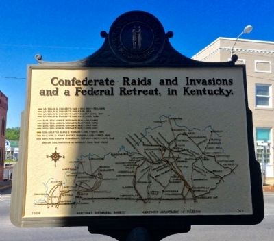
Confederate Raids Marker (Rear map)
| On Public Square at Burkesville Street (Kentucky Route 80), on the right when traveling south on Public Square. |
| On South 1st Street at East Locust Street, on the right when traveling north on South 1st Street. |
| On U.S. 25E, on the right when traveling north. |
| Near Washington Street (Kentucky Route 18) near Jefferson Street (Kentucky Route 338). |
| On Lower River Road, on the right when traveling north. |
| On Kentucky Route 8, on the left when traveling east. |
| On Ryle Road at Boat Dock Road (Kentucky Route 1925), on the right when traveling south on Ryle Road. |
| On Lower River Road, on the left when traveling west. |
| On Front Street at 15th Street, on the right when traveling west on Front Street. |
| On West Main Street (State Road 2200) at Oak Street, on the right when traveling west on West Main Street. |
| On West Main Street (Kentucky Route 2200) at Center Street, on the right when traveling west on West Main Street. |
| On West Hebron Lane, 0.1 miles south of John Harper Highway (Kentucky Route 1526), on the left when traveling south. |
| Near North Main Street at East Ohio Street, on the right when traveling north. |
| On Ferry Street (Kentucky Route 369) at Creamery Street, on the right when traveling north on Ferry Street. |
| On Park Street east of Woodbury Loop, on the right when traveling east. |
| On Lock 4 Road, 0.1 miles east of Barren River Road (Kentucky Highway 403), on the left when traveling east. |
| On East Washington Street west of Edwards Avenue, on the left when traveling east. Reported missing. |
| Near Fort Heiman Road, 0.6 miles east of Kline Trail, on the left when traveling east. |
| On Fort Heiman Road south of County Road 1242D4, on the left when traveling south. |
| On Clayridge Road south of Smith-Hiteman Road, on the right when traveling south. |
| On Alexandria Pike (U.S. 27) at Kenton Station Road (Kentucky Route 1936), on the right when traveling south on Alexandria Pike. |
| Near Riverboat Row, on the right when traveling south. |
| Near Riverboat Row, on the right when traveling north. |
| On Athens Boonesboro Road (Kentucky Route 418) north of Boonesboro Road (Kentucky Route 627), on the right when traveling south. |
| On Athens Boonesboro Road (Kentucky Route 418 at milepost 4.4), 0.1 miles east of Hidden Grove Lane, on the right when traveling west. |
| Near Ford Road/4 Mile Road (Kentucky Route 1924) 1.2 miles south of Boonesboro Road (Kentucky Route 627), on the left when traveling south. |
| Near Railroad Avenue south of Poplar Street, on the right when traveling south. |
| On State Highway 66, 0.6 miles north of U.S. 421, on the right when traveling south. |
| On State Highway 66, 0.6 miles north of U.S. 421, on the right when traveling south. |
| On North Washington Street at Cumberland Street, on the left when traveling north on North Washington Street. |
| On Sturgis Road (U.S. 60) at Adams Street on Sturgis Road. |
| On Banks Street south of Upper River Street, on the right when traveling south. |
| On Celina Road (Kentucky Route 61) 0.4 miles north of Cold Springs Road, on the right when traveling south. |
| On River Road (State Road 331), on the right when traveling north. |
| On Nolin Dam Road (Kentucky Route 728), on the right when traveling east. |
| On Brier Creek Road, 0.5 miles west of Nolin Church Road, on the left when traveling west. |
| Near Mammoth Cave Parkway, 0.5 miles west of Beaver Dam Chapel Road. |
| On Main Street (Kentucky Route 89) south of Geneva Avenue, on the right when traveling south. |
| On Coronado Ridge, 0.1 miles south of Sprinters Trail, on the right when traveling south. |
| On Old Frankfort Pike at Alexandria Drive, on the right when traveling east on Old Frankfort Pike. |
| On Dunkirk Drive east of Dunkirk Court, on the right when traveling west. |
| On Parkers Mill Road (Kentucky Route 1968) north of Chinquapin Lane, on the left when traveling north. |
| On West Main Street (U.S. 421, 25) 0.2 miles west of Algonquin Street, on the left when traveling west. |
| On South Front Avenue just south of Richmond Plaza, on the right when traveling south. |
| On South Front Avenue (County Route 3384) at West Graham Street, on the right when traveling south on South Front Avenue. |
| On KY-1428, 0.6 miles east of KY-302, on the right when traveling east. |
| On Wilkinson Boulevard, on the right when traveling south. |
| Near Wilkinson Boulevard (U.S. 421) north of West Plaza Connector Road (U.S. 127), on the right when traveling south. |
| On East Main Street (U.S. 60/460). |
| On Wilkinson Boulevard, on the right when traveling south. |
| On Wilkinson Boulevard, on the right when traveling south. |
| On Wilkinson Boulevard, on the right when traveling south. |
| On Wilkinson Boulevard, on the right when traveling south. |
| On U.S. 42 at U.S. 127, on the right when traveling west on U.S. 42. |
| On Falls of Rough Road (State Road 79) at Robinson Road, on the right when traveling south on Falls of Rough Road. |
| On South Clinton Street at East Main Street, on the right when traveling south on South Clinton Street. |
| On Elizabethtown Road (U.S. 62) at Shaw Station Road, on the right when traveling west on Elizabethtown Road. |
| Near Main Road (State Highway 1711) south of Pool Road, on the right when traveling north. |
| On Indian Lake Drive (State Road 3199) at Scenic Hilltop Road, on the right when traveling west on Indian Lake Drive. |
| On U.S. 60 at Jennings Street, on the right when traveling north on U.S. 60. |
| On Dixie Highway East (U.S. 31W), on the right when traveling west. |
| On North 4th Street, on the right when traveling north. |
| On Elm Street at North 3rd Street, on the right when traveling east on Elm Street. |
| On Elm Street at North 4th Street, on the right when traveling east on Elm Street. |
| Near River Road east of Old Street. |
| On Main Street (U.S. 31W) at East Union Street (State Road 357), on the left when traveling south on Main Street. |
| On South Elm Street at Center Street, on the right when traveling south on South Elm Street. |
| Near North Water Street at 1st Street. |
| Near North Water Street north of 1st Street, on the left when traveling north. |
| Near North Water Street south of 2nd Street, on the left when traveling north. |
| Near North Water Street south of 2nd Street, on the left when traveling north. |
| On Troutman Hill Road at Drennon Road, on the right when traveling north on Troutman Hill Road. |
| On U.S. 421 north of Kelley Road, on the right. |
| On Moorman Road, on the left when traveling west. |
| On Poplar Avenue, 0.1 miles east of Cave Hill Road, on the right when traveling east. |
| On Dixie Highway (U.S. 60) at Depot Lane, on the right when traveling north on Dixie Highway. |
| On East River Road at E Witherspoon Street, on the right when traveling east on East River Road. |
| Near West River Road at North 4th Street, on the right when traveling west. |
| Near West River Road at North 4th Street, on the right when traveling west. |
| Near West River Road at North 4th Street, on the right when traveling west. |
| On W Main Street at N 6th Street, on the right when traveling west on W Main Street. |
| On Guthrie Street near S 4th Street, on the right when traveling west. |
| On W. Main Street (U.S. 31W) at N. 4th Street, on the right when traveling west on W. Main Street. |
| On West River Road at North 4th Street, on the right when traveling west on West River Road. |
| Near West River Road at North 4th Street, on the right when traveling west. |
| Near West River Road at North 4th Street, on the right when traveling west. |
| On North 2nd Street at Clark Memorial Bridge, on the left when traveling north on North 2nd Street. |
| Near West River Road at North 4th Street, on the right when traveling west. |
| On Louisville Riverwalk just west of Clark Memorial Bridge. |
| On Bank Street east of North 38th Street, on the left when traveling east. |
| On Portland Avenue south of North 16th Street, on the right when traveling north. Reported damaged. |
| On Rudd Avenue, on the right when traveling west. |
| On Northwestern Parkway south of North 23rd Street, on the right when traveling south. |
| On Old Park Road, 0.1 miles east of Lock 7 Road, on the right when traveling east. |
| On Riverside Drive, on the right when traveling east. |
| On Philadelphia Street at West 6th Street, on the right when traveling south on Philadelphia Street. |
| On Riverside Drive at Garrard Street, on the left when traveling west on Riverside Drive. |
186 entries matched your criteria. The first 100 are listed above.
The final 86 ⊳