On Public Square at Burkesville Street (Kentucky Route 80), on the right when traveling south on Public Square.
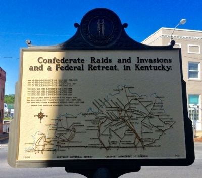
General John Hunt Morgan's cavalry, returning from second Kentucky raid, passed here on way back to Tennessee, Jan. 1, 1863. On raid, Union's rail supply line wrecked and $2,000,000 property destroyed. July 3, 1863, Morgan here again drove out . . . — — Map (db m83391) HM
On South 1st Street at East Locust Street, on the right when traveling north on South 1st Street.
Allen County was formed in April 1815. Scottsville was named for Gen. Charles Scott, 4th governor of Ky. In 1816, location was chosen for county seat because of abundant water supply from this spring. County bought 100 acres, which were laid off in . . . — — Map (db m143071) HM
Near this site where the creek enters the river, on April 17, 1750, Dr. Thomas Walker first viewed the river he named for the Duke of Cumberland. Known as the "Narrows," this area became a significant gateway for travelers on the Wilderness Road. . . . — — Map (db m181163) HM
Near Washington Street (Kentucky Route 18) near Jefferson Street (Kentucky Route 338).
Boone County was established in 1799 and the County Court held its first meeting in June of that year, where The Court proceeded to fix on a place for the Seat of Justice on 74 acres offered by Robert Johnson and John H. Craig. Initially known as . . . — — Map (db m134232) HM
On Lower River Road, on the right when traveling north.
One of only a few
remaining early 19th century towns along the 981-
mile course of the Ohio River. The Rabbit Hash
National Registry encompasses 33 acres of
this linear rural/agricultural/commercial village,
characterized by its eclectic . . . — — Map (db m79231) HM
On Kentucky Route 8, on the left when traveling east.
1937 Flood at Constance
The Ohio River reached its peak
on Jan. 26 at 79.9 ft. surpassing
the 1884 record. Constance was the
hardest hit town in Boone Co. but
there were no fatalities. Route 8
between Constance & Taylorsport
was almost . . . — — Map (db m133629) HM
On Ryle Road at Boat Dock Road (Kentucky Route 1925), on the right when traveling south on Ryle Road.
Discovered in 1739 by French Capt. Charles Lemoyne de Longueil. Early explorers found countless bones and teeth of extinct Pleistocene elephants, the mammoth and the mastodon. This saline-sulphur spring was popular for salt making until 1812: also a . . . — — Map (db m175117) HM
On Lower River Road, on the left when traveling west.
Piatt's Landing
Near here on the north bank of the
Ohio River at mile 510.5 was a
riverboat landing, ferry, and road
to the courthouse at Burlington.
The landing and large brick home
that once stood near, later called
Winnfield . . . — — Map (db m79142) HM
On Front Street at 15th Street, on the right when traveling west on Front Street.
Built Dubuque, Iowa in 1928 (Originally named John W. Weeks) This vessel was retired from service and presented to the city of Ashland, Kentucky by Armco Steel Corporation September 1, 1960 — — Map (db m228074) HM
On West Main Street (State Road 2200) at Oak Street, on the right when traveling west on West Main Street.
Cloverport, an important shipping point beginning in 1798 when Joe Houston came from Va.: built home and started trading and shipping business. Flatboats carried Ky. tobacco, other goods for sale in New Orleans. Boats sold as lumber. Men came back . . . — — Map (db m160276) HM
On West Main Street (Kentucky Route 2200) at Center Street, on the right when traveling west on West Main Street.
Abraham Lincoln, then a lad of 7, with other members of the Thomas Lincoln family crossed the Ohio River on a log raft ferry near here in 1816. The Lincolns were moving to Indiana. — — Map (db m119796) HM
On West Hebron Lane, 0.1 miles south of John Harper Highway (Kentucky Route 1526), on the left when traveling south.
Brooks' Spring
The spring here, first called Stewart's or Phillips' and then Brooks' Spring, was a well-known camping place in the early 1780s on the main route from the Falls of the Ohio & Beargrass Creek to Bullitt's Lick and Harrodsburg. . . . — — Map (db m174479) HM
Near North Main Street at East Ohio Street, on the right when traveling north.
Born in Chicago, Il., he moved to Butler Co. in 1874 & was educated in public and private schools here. After serving as Butler Co. Circuit Court Clerk (1893-96) he studied law and was admitted to the bar in 1898. He moved to Louisville in 1900 & . . . — — Map (db m123452) HM
On Ferry Street (Kentucky Route 369) at Creamery Street, on the right when traveling north on Ferry Street.
The town of Suffolk, originally called “Bluff,” established here by Logan Co. Court in 1803. Site recognized importance of Green River for future development of valley and State of Kentucky. The court appointed trustees: Reuben . . . — — Map (db m123460) HM
On Park Street east of Woodbury Loop, on the right when traveling east.
Federal Headquarters for
Green and Barren River Navigation
from 1912 until the 1930s. Today the
building houses exhibits focusing on
the history and culture of the Green River
region, with a special emphasis on
Butler County. — — Map (db m159196) HM
On Lock 4 Road, 0.1 miles east of Barren River Road (Kentucky Highway 403), on the left when traveling east.
The career of this naval officer spanned Spanish-American War and World Wars I and II. A native of Butler County, he attended public schools and Ogden College in Bowling Green;
graduated from Annapolis, 1899. Assumed command of USS . . . — — Map (db m159198) HM
On East Washington Street west of Edwards Avenue, on the left when traveling east. Reported missing.
Saline, Eddy, and Varmint traces met at Big Spring (Princeton) and developed into today's roads. First forged by buffalo, later used by Indians and pioneers. A fork of Saline crossed Ohio River at Cave-in-Rock; another at Golconda, Ill. Eddy Trace . . . — — Map (db m124356) HM
Near Fort Heiman Road, 0.6 miles east of Kline Trail, on the left when traveling east.
Two of the ironclad gunboats that attacked Fort Henry on February 6, 1862, were among several designed by Samuel S. Pook for the U.S. War Department in 1861. They were called "Pook Turtles" because their sloping rectangular sides, called casemates, . . . — — Map (db m231256) HM
On Fort Heiman Road south of County Road 1242D4, on the left when traveling south.
In late October 1864 Brig. Gen. Nathan Bedford Forrest and 3,500 Confederate cavalrymen used Fort Heiman as a base to attack Union supply vessels on the Tennessee River. After placing several artillery pieces along this bluff, Forrest's troopers . . . — — Map (db m173070) HM
On Clayridge Road south of Smith-Hiteman Road, on the right when traveling south.
Many salt wells located in this area, left over from the last Ice Age. Salt making was an early business in Grant's Lick. John Grant was one of the owners, and the entire area is named for him. Mary (Boone) Bryan — sister to Col. Daniel Boone — is . . . — — Map (db m175100) HM
On Alexandria Pike (U.S. 27) at Kenton Station Road (Kentucky Route 1936), on the right when traveling south on Alexandria Pike.
Ca. 1793, salt water found here by
Samuel Bryan, a nephew of Daniel
Boone. John Grant, another Boone
nephew, and Charles Morgan helped
him drill well, which supplied salt
to interior of Ky. This territory
was owned by John Grant and named
for . . . — — Map (db m175099) HM
Near Riverboat Row, on the right when traveling south.
Covington and Newport sit at the confluence of the Ohio and the Licking. Over the years the rivers have brought many benefits — natural beauty, trade, jobs. But they also have brought floods.
For generations citizens have accepted as . . . — — Map (db m174907) HM
Near Riverboat Row, on the right when traveling north.
Before pioneer families settled Kentucky and Ohio, Native Americans followed the Licking River to the grasslands of central Kentucky to hunt abundant buffalo and deer. The early settlers probably named the river for the many salt licks nestled in . . . — — Map (db m174777) HM
On Athens Boonesboro Road (Kentucky Route 418) north of Boonesboro Road (Kentucky Route 627), on the right when traveling south.
On July 14, 1776, Daniel Boone's daughter,
Jemima, and Richard Callaway's daughters,
Betsey and Fanny, left Fort Boonesborough
to canoe on the Kentucky River. They
drifted close to the bank near this spot and
were captured by five Native . . . — — Map (db m169694) HM
On Athens Boonesboro Road (Kentucky Route 418 at milepost 4.4), 0.1 miles east of Hidden Grove Lane, on the right when traveling west.
Colonel John Holder
John Holder commanded at Fort Boonesborough in 1779 and est. Holder's Station near the mouth of Lower Howard's Creek in 1782. He led a garrison at Vincennes in George Roger Clark's 1786 Wabash Campaign & was appointed a . . . — — Map (db m206154) HM
Near Ford Road/4 Mile Road (Kentucky Route 1924) 1.2 miles south of Boonesboro Road (Kentucky Route 627), on the left when traveling south.
Bridges, Fords and Ferries
Unlike the Ohio, the Kentucky River was never an important supply line for the Union Army. Because of its geology, the Kentucky acted as a barrier to the movement of supplies and men.
Much of the Kentucky . . . — — Map (db m74651) HM
Near Railroad Avenue south of Poplar Street, on the right when traveling south.
Salt works established early 1790s; Clay County established here in 1807
The Goose Creek Salt Works dates from the mid 1790s when it was known as the “Langford Works” and was well known throughout Kentucky and in . . . — — Map (db m87858) HM
On State Highway 66, 0.6 miles north of U.S. 421, on the right when traveling south.
Was a legendary Cherokee Indian for whom this fork of the Kentucky River is named. He and another Indian, Jack, whose name was given creek to the south, were friendly with early settlers and permitted to hunt in area. Allegedly they were killed in . . . — — Map (db m87567) HM
On State Highway 66, 0.6 miles north of U.S. 421, on the right when traveling south.
(Side One)
Named in honor of first white man to settle on Red Bird River, at the mouth of Gilbert’s Creek. A veteran of Revolutionary War, John Gilbert came here to hunt and trap. He surveyed and claimed much of Clay, Leslie and Harlan . . . — — Map (db m87568) HM
On North Washington Street at Cumberland Street, on the left when traveling north on North Washington Street.
For DeWitt Clinton, 1769-1828. In New York Senate, nine years; U.S. Senate, 1802-03, where he introduced XII Amendment, present method of electing U.S. president, vice president. Mayor, New York, nine years; leader, tax supported school movement. . . . — — Map (db m136583) HM
On Sturgis Road (U.S. 60) at Adams Street on Sturgis Road.
Returning from reconnaissance and foraging mission to Ohio River, CSA Gen. Nathan Bedford Forrest with cavalry here Dec. 1, 1861, learned of threats to and arrests of Southern sympathizers. While capturing a few instigators, regimental Surgeon S. M. . . . — — Map (db m123762) HM
On Banks Street south of Upper River Street, on the right when traveling south.
John Hunt Morgan’s Great Raid into Kentucky, Indiana and Ohio began in Cumberland County, Kentucky. The raid lasted 25 days and covered a thousand miles, making it the longest Confederate raid of the Civil War.
Morgan commanded 2,460 cavalrymen . . . — — Map (db m98884) HM
On Celina Road (Kentucky Route 61) 0.4 miles north of Cold Springs Road, on the right when traveling south.
During late June 1863 Confederate Gen. John Hunt Morgan's scouts and portions of his nine regiments moved into Cumberland County preparing for the Great Raid in Kentucky, Indiana, and Ohio.
The 1st Brigade, numbering 1,450 cavalrymen under Col. . . . — — Map (db m98882) HM
On River Road (State Road 331), on the right when traveling north.
Robert Triplett built the first railway in Kentucky, 1826. Coal was moved from Bon Harbor hills to steamboats on the Ohio River. Triplett was first to get coal substituted for wood as fuel on river boats below Louisville. Coal was shipped south, . . . — — Map (db m160127) HM
On Nolin Dam Road (Kentucky Route 728), on the right when traveling east.
Nolin River Lake is a multipurpose flood control project operated by the U.S. Army Corps of Engineers. Any run-off which falls in Nolin Lake’s 703 square mile watershed will eventually flow through the dan’s conduit and into Nolin River below the . . . — — Map (db m233348) HM
On Brier Creek Road, 0.5 miles west of Nolin Church Road, on the left when traveling west.
The Nolin River is named for the early American explorer and Kentucky militia member Benjamin Lynn. Serving under George Rogers Clark during the Revolutionary War, Lynn traveled to Illinois to spy on the British and Indian forces, and also played a . . . — — Map (db m233349) HM
Near Mammoth Cave Parkway, 0.5 miles west of Beaver Dam Chapel Road.
The Green River linked the nineteenth-century Mammoth Cave community to the rest of the world. Kentucky pioneers found it less expensive and more efficient to transport large loads by Green River than by horse and wagon over rough overland roads. . . . — — Map (db m233237) HM
On Main Street (Kentucky Route 89) south of Geneva Avenue, on the right when traveling south.
Mineral springs visited by Boone, Boyle, McAfee and other pioneers. Early camp of Shawnee Indians. First school of early settlers located here. Operated as resort, 1814 until hotel burned 1924. In 1861, owner Col. Sidney M. Barnes organized 8th Ky. . . . — — Map (db m136947) HM
On Coronado Ridge, 0.1 miles south of Sprinters Trail, on the right when traveling south.
This spring 900 feet to the west was discovered in 1775 by Joseph Lindsay who was killed at the Battle of Blue Licks. Spring and surrounding 2,000 acres were later surveyed for Evan Shelby, father of the first governor of Kentucky. The house on . . . — — Map (db m170027) HM
On Old Frankfort Pike at Alexandria Drive, on the right when traveling east on Old Frankfort Pike.
...an unusual name... for a remarkable place
The Big Sink Rural Historic District, the largest along Old Frankfort Pike and in the Lexington-Frankfort Scenic Corridor, echoes almost
all of the themes and eras depicted in the area's . . . — — Map (db m196514) HM
On Dunkirk Drive east of Dunkirk Court, on the right when traveling west.
The stream in this valley emerges
from a cave. It was part of 1,000-
acre Cave Spring Tract, on waters
of South Elkhorn Creek, owned by
Col. William Preston. The water is
connected underground with sinking
spring of Wm. McConnellI. . . . — — Map (db m170024) HM
On Parkers Mill Road (Kentucky Route 1968) north of Chinquapin Lane, on the left when traveling north.
In this valley is a deep spring
known as the Blue Hole. It was
discovered in 1775 by William
McConnell who built a cabin and
later traded the 400-acre claim
to Simon Kenton, who was known
as Simon Butler at that time.
Joseph Frazer then . . . — — Map (db m170022) HM
On West Main Street (U.S. 421, 25) 0.2 miles west of Algonquin Street, on the left when traveling west.
Under Vine Street flows the Town Branch of Elkhorn, the stream upon whose banks Lexington was established in 1779. Used in the early days to bring merchandise to Lexington from Ohio River. On Town Branch was launched Edward West's steamboat in 1793. . . . — — Map (db m58557) HM
On South Front Avenue just south of Richmond Plaza, on the right when traveling south.
Frenchman Solomon DeRossett built a log house on this site in 1799. Collected fur pelts for Napoleon Bonaparate’s army. Levisa River served as first conduit for travel and means of importing frontier supplies. During spring rains, huge log rafts . . . — — Map (db m146053) HM
On South Front Avenue (County Route 3384) at West Graham Street, on the right when traveling south on South Front Avenue.
Rubin Ferguson lived here and operated a ferry and boat dock during the late 1800’s. Barrels of meal, flour, corn, coffee, cotton, tools and building materials arrived here from various ports down river. Some of the boats were “The Andy . . . — — Map (db m146050) HM
On KY-1428, 0.6 miles east of KY-302, on the right when traveling east.
Doris Faye Burchett • James Edison Carey • Glenda May Cisco • Kenneth Forrest Cisco • Paulette Cline • Sandra Faye Cline • Linda Darby • Emogene Darby • James Edward Goble • John Spencer Goble • Anna Laura Goble • Jane Carol Harris • Margaret Louise . . . — — Map (db m212046) HM
On Wilkinson Boulevard, on the right when traveling south.
The Kentucky River Water Trail in Kentucky is designated a
keystone conservation and outdoor recreation project under
President Obama's America's Great Outdoors program. Here, we
celebrate the partnerships and collaboration that resulted in . . . — — Map (db m194234) HM
Near Wilkinson Boulevard (U.S. 421) north of West Plaza Connector Road (U.S. 127), on the right when traveling south.
Kentucky River Lock and Dam Four are about half a mile north of Kentucky River View Park. They are part of a system of fourteen locks and dams built on the river between the 1830s and 1917. Both state and federal governments contributed to the . . . — — Map (db m62267) HM
First American to raise U.S. flag on foreign soil at Battle of Derne on shores of Tripoli, April 27, 1805. Led attack that overcame Barbary Coast pirates who were holding 180 American seamen for ransom. O'Bannon came to Logan County in 1807. Served . . . — — Map (db m9753) HM
On Wilkinson Boulevard, on the right when traveling south.
The headwaters of the Kentucky River are in the mountains of Eastern Kentucky. Its two main branches-the North and South Forks of the Kentucky River-come together at Beattyville. From there, the river flows about 255 miles to Carrollton, where it . . . — — Map (db m194220) HM
On Wilkinson Boulevard, on the right when traveling south.
The Kentucky River Authority was established in 1986 to take
over operation from the United States Army Corps of Engineers
of ten locks and dams and adjacent property upriver from
Frankfort.
As the commonwealth's first major watershed . . . — — Map (db m194215) HM
On Wilkinson Boulevard, on the right when traveling south.
Steamboats no longer pass through the Kentucky River locks; log rafts no longer
splash over the dams; and showboats no longer bring music and drama to small Kentucky towns, but the Kentucky River remains of vital importance to the people of central . . . — — Map (db m194221) HM
On Wilkinson Boulevard, on the right when traveling south.
Opened in 1997, Kentucky River View park was a cooperative project of the
Kentucky River Authority, the Kentucky Economic Development Cabinet, the
City of Frankfort, Franklin County Fiscal Court, the Kentucky Transportation
Cabinet, the Kentucky . . . — — Map (db m194235) HM
On U.S. 42 at U.S. 127, on the right when traveling west on U.S. 42.
At midnight of Dec. 4, 1868 two cabined
passenger steamers plying between Louisville
and Cincinnati collided two miles above
Warsaw. The America rammed deeply into the
United States. Barrelled coal oil on deck of
the latter caught . . . — — Map (db m136087) HM
On Falls of Rough Road (State Road 79) at Robinson Road, on the right when traveling south on Falls of Rough Road.
George Eskridge, born in Virginia in 1763, served in Revolutionary War, having enlisted in the Virginia Continental line at an early age. Eskridge came to Kentucky and settled in Grayson County, circa 1811. Built a log house at Falls of Rough River . . . — — Map (db m162247) HM
On South Clinton Street at East Main Street, on the right when traveling south on South Clinton Street.
Leitchfield was laid off 1810, and named for David Leitch, prominent landowner and founder of Leitch's Station. His estate gave land for Grayson's county seat. Site chosen because of fresh water springs, particularly "Big Spring" nearby. Grayson's . . . — — Map (db m123434) HM
On Elizabethtown Road (U.S. 62) at Shaw Station Road, on the right when traveling west on Elizabethtown Road.
Shaw's Station
Named for Benham (Bonum) Shaw, this pioneer settlement (today's Leitchfield) was located at the headwaters of Beaver Dam Creek. This station was a stop along the important trail which ran from settlements at Nashville, Tenn., . . . — — Map (db m123433) HM
Near Main Road (State Highway 1711) south of Pool Road, on the right when traveling north.
The centerpiece of Greenbo Lake State Resort Park is beautiful 225-acre Greenbo Lake.
Explore the lake with a relaxing canoe, motor boat or pontoon ride or by bicycle. Bike and
boat rentals make it easy and enjoyable. Try your
luck at fishing . . . — — Map (db m162506) HM
On Indian Lake Drive (State Road 3199) at Scenic Hilltop Road, on the right when traveling west on Indian Lake Drive.
Below is view of the river bottom land where John Cannon, riverboat captain and builder
of fine steamboats for lower Mississippi trade, was born in l820. By 1840 this skilled pilot began his career as steamboat entrepreneur. He built and piloted . . . — — Map (db m160229) HM
On U.S. 60 at Jennings Street, on the right when traveling north on U.S. 60.
Captain William Davison
Confederate Captain William Davison is buried here. He died March 7, 1865, from a gunshot wound suffered in a firefight with Union Home Guard, February 24, 1865, near Patesville during the Civil War. Davison led a . . . — — Map (db m160225) HM
On Dixie Highway East (U.S. 31W), on the right when traveling west.
Here along Severn's Valley Creek, Samuel Haycraft, Sr. built mill, raceway in 1796. Thomas Lincoln, father of Pres. Lincoln, employed in building it, received his first monetary wages when about 21 years of age. Abraham Lincoln, age 7, with his . . . — — Map (db m25137) HM
On North 4th Street, on the right when traveling north.
The boat landing for West Point was known by its Spanish name of "Embarcadero." Flatboats would leave from here for New Orleans. — — Map (db m122105) HM
On Elm Street at North 3rd Street, on the right when traveling east on Elm Street.
From 1796 until about 1860, a Salt Warehouse stood on this lot. Salt was manufactured near here, thus Salt River received its name. — — Map (db m122108) HM
On Elm Street at North 4th Street, on the right when traveling east on Elm Street.
In early spring of 1806, Thomas Lincoln, who was to become the father of Abraham Lincoln, took a flatboat loaded with produce from the West Point boat landing to New Orleans. The trip, requiring about sixty days, was a profitable one and enabled . . . — — Map (db m122097) HM
When a town was settled, the settlers most often chose the site because of a nearby crossroads, or, more importantly, because of nearby natural resources - especially water. Town founder Richard Munford had the best of both here, with the easy . . . — — Map (db m40023) HM
On Main Street (U.S. 31W) at East Union Street (State Road 357), on the left when traveling south on Main Street.
Side A In the winter of 1780, Daniel & Rebecca Boone and their young son, William, (b. June 20, 1775) camped at the Ebb & Flow Spring near Green River, 4 miles east of here. The Boones were hunting and trapping as they did every winter for . . . — — Map (db m41844) HM
On South Elm Street at Center Street, on the right when traveling south on South Elm Street.
By Kentucky Statute, Dec. 1798, effective, May 1799, the county of Henderson was formed out of part of Christian. Named to honor Col. Richard Henderson, founder of the Transylvania Land Company, which was granted land on Green and Ohio Rivers by Va. . . . — — Map (db m88971) HM
Lewis and Clark in Kentucky
Robert Frazer, a member of the 1803-06 Lewis & Clark Expedition, visited General Samuel Hopkins here in Feb. & April 1807. Frazer was traveling from St. Louis to Washington and back while helping the U.S. . . . — — Map (db m88964) HM
Near North Water Street north of 1st Street, on the left when traveling north.
Steamboats, with their capability to travel against the current, revolutionized river transportation and opened grand economic and social doors for Henderson. They lowered transportation costs, carried enormous loads of cargo, provided comfortable . . . — — Map (db m121690) HM
Near North Water Street south of 2nd Street, on the left when traveling north.
The Ohio River Valley's worst flood occurred in January-February 1937. Three weeks of continuous rain, sleet and snow dropped 21 inches of precipitation during this period. The Ohio River reached its crest in Henderson on February 1, 1937, at the . . . — — Map (db m121662) HM
Near North Water Street south of 2nd Street, on the left when traveling north.
From its starting point at the confluence of the Allegheny and Monongahela rivers in Pittsburgh, Pennsylvania, the Ohio River flows 981 miles in a southwesterly direction to Cairo, Illinois, where it joins the Mississippi River. Henderson, Kentucky, . . . — — Map (db m121678) HM
On Troutman Hill Road at Drennon Road, on the right when traveling north on Troutman Hill Road.
Discovered & used by Indians for its medical properties. Claimed by Jacob Drennon & Mattmew Bracken, members of the McAfee Company, July 7 1773. Site of Drennon Springs Hotel and Western Military Institute. — — Map (db m175125) HM
The Mississippi River looms large in our history. Early on, it marked the nation's westernmost boundary. As the country expanded, the river became the eastern border of the western frontier. "The Mighty Mississippi" linked far-flung places in . . . — — Map (db m37123) HM
Settlement and Early Growth The French explorers Marquette and Joliet first explored the area around Columbus in 1673. The French gave Columbus the name "Iron Banks," believing the color of the banks indicated the presence of iron. In 1783, . . . — — Map (db m37014) HM
The Mississippi River in the Civil War "Whatever nation gets control of the Ohio, Mississippi and Missouri Rivers, will control the continent." Union General William Tecumseh Sherman, 1861 The goal of both the Northern (Federal or Union) . . . — — Map (db m37355) HM
Along War Fork Creek, two miles east, coursed a primeval trail between the Shawnees of Ohio and Cherokees of east Tennessee. The Indians called it Athiamiowee, Path of the Armed Ones. On English map, 1755. Path was followed by Gabriel Arthur, when . . . — — Map (db m136644) HM
For most of the 19th century this house was center of prosperous Ohio River farm with an active riverboat landing. Built circa 1837 by Gabriel Farnsley (1800-1849). House and 200-acre farm site purchased, 1862, by Alanson Moremen (1803-90). . . . — — Map (db m161672) HM
On Poplar Avenue, 0.1 miles east of Cave Hill Road, on the right when traveling east.
This statesman and entrepreneur fostered Louisville's growth from small town in 1810 to nation's 10th largest city in 1850. Promoted building of Portland Canal and the first R.R. bridge over Ohio River. As president of the University . . . — — Map (db m161205) HM
On Dixie Highway (U.S. 60) at Depot Lane, on the right when traveling north on Dixie Highway.
Company town of Kentucky’s only Portland cement manufacturer. Philadelphia industrialist Samuel Horner Jr. developed housing for white and black workers of his Kosmos Portland Cement Co. in rural Jefferson County. A rail station, post office, . . . — — Map (db m161670) HM
On East River Road at E Witherspoon Street, on the right when traveling east on East River Road.
( first panel )
Abraham Lincoln, his hand and pen He will be good but God knows when. Abraham Lincoln, ca. 1826-26
Abraham Lincoln was born February 12, 1809, near Hodgenville, Kentucky. The Commonwealth of Kentucky dedicates this . . . — — Map (db m139475) HM
Near West River Road at North 4th Street, on the right when traveling west.
The Belle of Louisville, built in Pittsburgh in 1914, is the oldest continuously operating steamboat in the U.S. Warfboat LSS#10 is the only remaining inland Coast Guard Station in the U.S. Both were designated National Historic Landmarks in 1989. — — Map (db m104255) HM
Near West River Road at North 4th Street, on the right when traveling west.
Belle of Louisville
The Belle of Louisville was built (by the James Rees & Sons Company) in Pittsburgh in 1914 and commissioned the Idlewild. She first operated as a ferry at Memphis carrying passengers, freight, farm produce and . . . — — Map (db m104307) HM
Near West River Road at North 4th Street, on the right when traveling west.
Louisville’s most famous life saver at the Falls of the Ohio, Captain John F. (Jack) Gilooly (1855 - 1926), assisted in or effected the saving of 6,312 persons, property valued at $5,500,000, and recovery of 400 bodies of drowning victims. Perhaps . . . — — Map (db m104256) HM
On W Main Street at N 6th Street, on the right when traveling west on W Main Street.
A native of Wales, Williams came to Kentucky around 1780. In 1783, he built his distillery on the banks of the Ohio River, distilling whiskey from corn on the east side of what is now 5th Street. It is said to have been the first commercial . . . — — Map (db m104373) HM
On Guthrie Street near S 4th Street, on the right when traveling west.
This statesman and entrepreneur fostered Louisville's growth from small town in 1810 to nation's 10th largest city in 1850. Promoted building of Portland Canal and the first R.R. bridge over Ohio River. As president of the University of Louisville, . . . — — Map (db m178347) HM
On W. Main Street (U.S. 31W) at N. 4th Street, on the right when traveling west on W. Main Street.
Thornton and Lucie (also called Ruthy) Blackburn were slaves in Louisville, 1830-31. Thornton was hired out to Wurts and Reinhard's store at 4th and Main. When Lucie was sold to Virgil McKnight, the two escaped by steamboat. They were claimed two . . . — — Map (db m178310) HM
On West River Road at North 4th Street, on the right when traveling west on West River Road.
Life Saving Station 10
Life-saving stations, established by the Life-Saving Service, precursor to today's Coast Guard, were set up by the Federal Government along the western rivers in 1881 to provide aid to endangered river travelers. Louisville . . . — — Map (db m104309) HM
Near West River Road at North 4th Street, on the right when traveling west.
Evolving from the primitive landing of Louisville’s earliest days, the wharf had become a cobblestoned center of city life by the mid-1820s. By the 1850's, as many as 20 steamboats a day arrived and departed here. It was never more active than . . . — — Map (db m104311) HM
Near West River Road at North 4th Street, on the right when traveling west.
Mayor Andrew Broaddus
Has Been Designated A
National
Historic Landmark
This Site Posseeses National Significance
In Commemorating The History of the
United States of America
1989
National Park Service
United States Department of . . . — — Map (db m104308) HM
On North 2nd Street at Clark Memorial Bridge, on the left when traveling north on North 2nd Street.
In A.D. 1669 Robert Cavelier, Sieur de LaSalle, commissioned by the French officials of Louis XIV at Quebec, seeking a water route to China and Japan, guided by an Indian and accompanied by a party in canoes, descended this river, called by the . . . — — Map (db m126434) HM
Near West River Road at North 4th Street, on the right when traveling west.
U. S. Coast Guard World War II Operations in Louisville From November, 1942 - November, 1944, 134 Coast Guard temporary reservists conducted continuous river patrols from this station. Led by Lt. J.C. Theobald And Lt. (J.G.) W.T. Duvall, this . . . — — Map (db m104310) HM WM
On Louisville Riverwalk just west of Clark Memorial Bridge.
Visitors at Louisville Wharf
James Monroe June 1819 •
Andrew Jackson June 1819 •
Alexis de Tocqueville December 1831 •
Washington Irving September 1832 •
Abraham Lincoln September 1841 •
Charles Dickens April 1842 •
Walt Whitman . . . — — Map (db m83929) HM
On Bank Street east of North 38th Street, on the left when traveling east.
Mary M. Miller of Louisville, a pioneer among women, was issued license as master of a steamboat on inland waters, Feb. 16, 1884, in New Orleans. License authorized her to navigate waters of Ouachita, Mississippi, Red, and other western rivers. She . . . — — Map (db m68597) HM
On Portland Avenue south of North 16th Street, on the right when traveling north. Reported damaged.
By the late eighteenth century, large boats carried people and products to villages dotting the banks of the Ohio River. Yet the boats had to halt at the 26’ drop at the Falls of the Ohio where Louisville is today. Draymen portaged freight to the . . . — — Map (db m161709) HM
French immigrants established a community here in 1806. In 1814 it was surveyed and platted. By 1837 it was incorporated as a suburb of Louisville. It was an early port and boatbuilding center - 41 steamers had been built by 1855. Portland was site . . . — — Map (db m68536) HM
On Northwestern Parkway south of North 23rd Street, on the right when traveling south.
Built between 1845 and 1852, during the zenith of steamboat and river commerce, the U.S. Marine Hospital in Louisville served boatmen on the Western waterways. Designed by Robert Mills, one of the first American- born professionally trained . . . — — Map (db m161707) HM
On Old Park Road, 0.1 miles east of Lock 7 Road, on the right when traveling east.
The Kentucky River flows almost 225 miles from its origin near Pine Mountain in eastern Kentucky to Carrolton, where it joins the Ohio. In the Bluegrass, between Frankfort and Boonesborough, the meandering river is framed by palisades – imposing . . . — — Map (db m218247) HM
On Riverside Drive, on the right when traveling east.
Mary Greene was born the daughter of a country storekeeper. When she
married Captain Gordon C. Greene, she left the land to make her life and
raise her family on the rivers of America. Captain Mary one of the few
women to become a licensed boat . . . — — Map (db m78667) HM
On Riverside Drive at Garrard Street, on the left when traveling west on Riverside Drive.
Plaque #1
(APA logo)
the American Planning Association,
through Great Places in America,
designates
Historical Licking Riverside
Neighborhood
Covington, Kentucky
as a Great Neighborhood
2013
Plaque #2
Seven historic . . . — — Map (db m78756) HM
186 entries matched your criteria. The first 100 are listed above. The final 86 ⊳