On Farm to Market Road 861, 0.2 miles north of County Road 103, on the left when traveling north.
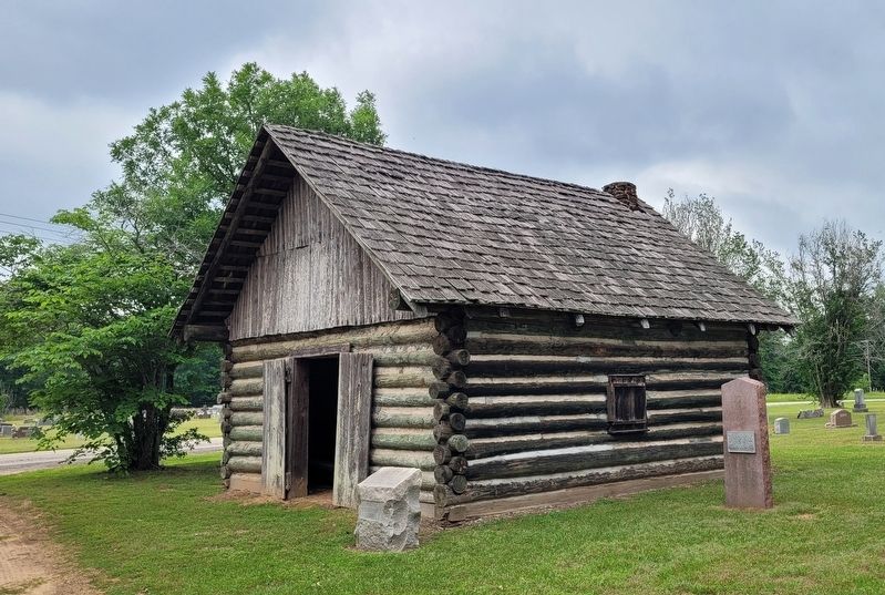
Replica Made 1949 of First Building Erected Here After Pilgrim Church Was Formed in 1833 by Elder Daniel Parker
Replica Reconstructed 1997 — — Map (db m245827) HM
On North Church Street (State Highway 19), on the right when traveling north.
Created by the Texas Legislature on March 24, 1846, Anderson County was named for former Republic of Texas Vice President Kenneth L. Anderson. The first court in the new county was held in a log house at nearby Fort Houston in 1846.
The first . . . — — Map (db m128934) HM
On East Hodges Street at North Church Street, on the right when traveling west on East Hodges Street.
In the 1870s, after the International & Great Northern Railroad line reached Palestine, brothers A. B. and Dan Hodges moved here from Tennessee Colony settlement and became leading merchants. This house was built in 1895 by Dan Hodges for his wife . . . — — Map (db m219437) HM
On South Magnolia Street north of West Reagan Street, on the left when traveling north.
Honored National Statesman from Palestine, congressman A.W. Gregg (1855-1919) lived in this house at height of his career. Gregg, member of a distinguished southern family, graduated from University of Virginia School of Law; practiced in Palestine; . . . — — Map (db m245939) HM
On Avenue A (State Highway 127) at North Elm Street, on the left when traveling east on Avenue A.
Palestine, founded 1846, acquired fire department when International & Great Northern Railroad extended line here in 1872. Early fire-wagon was horse-drawn flatbed loaded with hose. Motor truck and city water were introduced 1918. Bell from 1895 . . . — — Map (db m232794) HM
On East Oak Street at North Sycamore Street, on the right when traveling west on East Oak Street.
Land at this site was purchased in 1907 from St. Philip's Episcopal Church for a new post office for Palestine. Architects Deacon Armiger and Dunplap, under the supervision of U.S. Treasury architect James Knox Taylor, drew the plans, and . . . — — Map (db m245976) HM
On South Sycamore Street at East Angelina Street, on the right when traveling north on South Sycamore Street.
"Silk Stocking Row" Victorian residence built in 1890. Noted as family home of Mrs. Percy V. Pennybacker (1861-1938), teacher, author of widely used school history of Texas, first Texan president General Federation Women's Clubs.
Purchased 1900 . . . — — Map (db m245937) HM
On South Magnolia Street at Bowers Street, on the right when traveling south on South Magnolia Street.
Originally house of merchant Henry Ash, built 1878; bought 1884 by Andrew L. and Nellie O'Connell Bowers, who had architect-builder W.W. Wainright add cupola, gazebo, circular galleries after 1886. Charles Dunbar was architect in 1897 for ornate . . . — — Map (db m245942) HM
Near Henderson Street at Fulton Beach Road, on the left when traveling east.
Built between 1874 and 1877 by George Ware Fulton (1810 – 1893) and his wife, Harriet Smith Fulton (1823 – 1910), this imposing residence was named “Oakhurst”. The three-story French second empire style home is of plank wall . . . — — Map (db m53698) HM
On South Water Street south of East Market Street, on the right when traveling south.
Located on the waterfront in a community that has survived many hurricanes, this house was built about 1868 by Dr. John W. Baylor. In addition to his medical practice Dr. Baylor owned a local meat packing business, ranched, and worked to bring a . . . — — Map (db m53593) HM
On North Magnolia Street south of East Liberty Street (Route 35), on the left when traveling north.
Adolph L. Bracht (1872-1961) was born in Rockport and worked at lumber and grocery stores before establishing his own wholesale and retail grocery in 1899. He was a charter member of the Intracoastal Canal Association and active in the Chamber of . . . — — Map (db m53746) HM
On North Broadway Street (Loop State Highway 70) south of Chamber Drive, on the right when traveling south.
Built about 1868, this vernacular early Texas home was purchased in 1872 by James C. Fulton, a noted early business and civic leader. Fulton sold the home in 1907 to his son-in-law, Albert L. Bruhl, a pharmacist and civic leader who served three . . . — — Map (db m53749) HM
On Broadway Street (Loop State Highway 70) at Chamber Drive, on the right when traveling south on Broadway Street.
Prominent local businessman and land developer James M. Hoopes (1839-1931) had this home built between 1890 and 1892. The home later served as a hotel and boardinghouse between 1894 and 1930. It was sold in 1934 to T. Noah Smith, Sr. (1881-1955), a . . . — — Map (db m53587) HM
On South Church Street (State Highway 70) south of East Market Street, on the right when traveling south.
John M. Mathis (1831-1922) had this home built for his family in 1868-1869. Instrumental in platting the town of Rockport, he served as its first mayor in 1870. In 1880 he deeded the house to his cousin, Thomas H. Mathis (1834-1899), a leading . . . — — Map (db m53594) HM
On South Church Street at St Marys Street, on the right when traveling south on South Church Street.
Built in 1906, this house was the vision of James Edward (J. Ed) and Josephine Kennedy Moore. The two were married from 1903 until 1915, when Josephine passed away. J. Ed was a business owner who served several terms as Rockport’s mayor between the . . . — — Map (db m53743) HM
On South Austin Street (State Highway 70) at Wharf Street, on the left when traveling south on South Austin Street.
Built in 1889 by civic leader and politician John H. Traylor, the Aransas Hotel covered this city block. The three-story structure, a major tourist attraction in Rockport had about 100 rooms and a massive open dining room with a 200 person capacity. . . . — — Map (db m53583) HM
On South Austin Street (State Highway 70) south of Main Street, on the right when traveling north.
Simon Sorenson, a native of Denmark, bought Brunner’s Mercantile at this site in 1886. The building was originally two stories, rebuilt after an 1895 fire. The Sorensons received weather reports by telegraph, posted updates in the display windows . . . — — Map (db m53592) HM
On North Live Oak Street near East Mimosa Street, on the right when traveling south.
For more than 60 years, Rockport’s skyline was dominated by an imposing, three-story Moorish-inspired courthouse. It was the first major building designed by J. Riely Gordon, who would become one of Texas’ most famous architects. Born in Virginia in . . . — — Map (db m53768) HM
On East Pecan Street at North Sycamore Street, on the right when traveling west on East Pecan Street.
By 1909 Archer County had outgrown its original jail, a 16-foot square frame building. Construction on this larger facility was completed in Sept. 1910. The sandstone structure was designed with living quarters for the sheriff and his family on the . . . — — Map (db m187143) HM
On West 1st Street (U.S. 287) at Parks Street, on the right when traveling west on West 1st Street.
Erected in 1953, this building is constructed of stone used to build the first masonry jail in Armstrong County, 1894. Stone for the structure (which replaced a primitive, frame "calaboose") was quarried 14 miles south at Dripping Springs in Palo . . . — — Map (db m96830) HM
On Farm to Market Road 2272, 2.3 miles east of Texas Highway 207, on the left when traveling east.
William Miles Dye was born in Kentucky in 1864 and moved to Texas with his parents in 1870. He settled in this area in 1891, one year after the organization of Armstrong County. By hauling rock from Palo Duro Canyon, Dye helped in the construction . . . — — Map (db m100511) HM
Near County Road 25, 0.2 miles south of U.S. 287, on the right when traveling south.
First ranch in the Texas panhandle
Established in 1876 by
Charles Goodnight
1836- 1929
Noted scout, Indian fighter, trail blazer
and rancher
The Burbank of the range — — Map (db m49328) HM
Atascosa County was created from Bexar County in 1856. The first county seat was at Navatasco, on land donated by Jose Antonio Navarro, and the county's first courthouse was a log cabin. The county seat was moved to Pleasanton in 1858, and a frame . . . — — Map (db m56584) HM
On Oak Street (State Highway 97) at Campbell Avenue, on the right when traveling east on Oak Street.
This log cabin is a replica of first courthouse built 1856 near Amphion (Navatasco) 9 miles to the northwest, on site given by Jose Antonio Navarro out of his 1828 grant from Coahuila and Texas. A signer of the Texas Declaration of Independence, he . . . — — Map (db m56636) HM
County officials rented a small Jourdanton house for a jail in 1911 after the county seat was moved here from Pleasanton in 1910. A proposal to build a new jail with cells from the old Pleasanton structure was rejected and this reinforced-concrete, . . . — — Map (db m56585) HM
On South Bell Street at West Luhn Street, on the right when traveling south on South Bell Street.
Calling their old jail "unsafe, unfit, and inadequate," the Austin County Court contracted in 1896 with Pauly Jail Building Co. of St. Louis to erect this structure at cost of $19,970. Romanesque Revival style, with crenelated parapets, bartizans, . . . — — Map (db m125600) HM
On Main Street (State Highway 173) north of Hackberry Street, on the right when traveling north.
First permanent courthouse for county, which was organized in 1856, but used makeshift quarters for offices and courtrooms until this building was erected 1890-91. Style is local version of the Second Renaissance Revival. White limestone for the . . . — — Map (db m111201) HM
Georgia stonemason Henry White is credited with building this structure about 1868. In 1877 a store occupied the first floor and the Masonic Lodge met on the top floor. County commissioners bought the building that year to provide space for county . . . — — Map (db m130355) HM
On Main Street (State Highway 173) at Cypress Street, on the right when traveling south on Main Street.
Built 1873 for E. Huffmeyer & brother, by B.F. Langford, Sr., contractor; of native stone.
Bandera's oldest building. Used over 30 years by W.J. Davenport, Sr., as general store. Damaged by fire, 1936.
Restored and remodeled by Thomas . . . — — Map (db m111521) HM
Built 1881. Local stone, cypress floors used. Housed county offices until 1890. Used 57 years. Recorded Texas Historic Landmark - 1965 — — Map (db m130354) HM
On Wilson Street at Buttonwood Street, on the left when traveling north on Wilson Street.
The Bastrop Academy opened in 1851 with Prof. William J. Hancock of Aberdeen, Mississippi as headmaster. He arrived in early 1852 and built this house for his family and student boarders. The Academy became the Bastrop Military Institute in 1857, . . . — — Map (db m195984) HM
Near Pine Street at Water Street, on the right when traveling east.
Designed by Eugene T. Heiner of Houston, this building was erected in 1891-92 by contractors Martin, Byrne & Johnston. Red brick trim decorates the tan brick walls.
A pressed metal cornice encircles the structure, and a mansard roof tops one . . . — — Map (db m126757) HM
On Main Street at Buttonwood Street, on the right when traveling north on Main Street.
Alexander M. and Althea Brooks built this Greek Revival style home of native cedar and pine by 1851. James Harvey and Dorothy (Olive) Wilbarger acquired the property in 1865. James, son of noted scalping victim Josiah Wilbarger, served as a teenager . . . — — Map (db m219474) HM
On Main Street near Chestnut Street, on the right when traveling north.
Site - sold 1835 to John F. Webber by Ayuntamiento of Mina - by 1855 was occupied by structure built of local brick and "Lost Pines" wood. Among physicians who had offices in rear was Dr. David Sayers (father of Governor Joseph D. Sayers), . . . — — Map (db m196134) HM
On Main Street south of Spring Street, on the right when traveling south.
First bank in county. In early days, money for safekeeping was placed with mercantile firms.
Organized as "Bank of Bastrop County," in March 1889; became a national bank on Aug. 10, 1889.
Presidents of this bank have been J.C. Buchanan, . . . — — Map (db m65150) HM
On Pecan Street at Beech Street, on the left when traveling north on Pecan Street.
Built 1906 by J. P. Fowler, Jr. Bought 1912 by Hartford and Beulah Alice (Hemphill) Jenkins, whose heirs still own house. Jenkins, the first county superintendent of schools, also was a county judge, commissioner, and clerk of district . . . — — Map (db m219441) HM
On Pecan Street at Chestnut Street (State Highway 150), on the right when traveling north on Pecan Street.
1873, built by Joe Jung, a Bohemian - Austrian - American. Has sun dried brick in original two rooms. Purchased by the Pearcy family, 1936.
Recorded Texas Historic Landmark - 19642nd Plaque
Entered in the National . . . — — Map (db m196137) HM
On Main Street at Pine Street, on the left when traveling north on Main Street.
William Kesselus, a native of Germany, came to Bastrop in 1853 and established himself as a tailor. In 1891, this building was constructed to replace an earlier frame structure that had housed his shop. After Kesselus died in 1901, his son Will . . . — — Map (db m196131) HM
On Main Street at Pine Street, on the left when traveling north on Main Street.
Prussian immigrant Carl Kleinert and his wife, Marie (Wilke), moved to Bastrop in the early 1860s. One of many early German merchants in Bastrop, Kleinert built his grocery and mercantile on this site in 1868. The building has housed many businesses . . . — — Map (db m196129) HM
On Pecan Street at Beech Street, on the right when traveling north on Pecan Street.
Henry Klockman (1852-1897) and his wife bought this land in 1894 and built this home about 1895. Klockman operated a blacksmith shop until his death. His widow supported their son by taking in boarders. She sold the residence in 1910 to P. O. . . . — — Map (db m219442) HM
On Main Street at Walnut Street, on the left when traveling north on Main Street.
A native of Germany who came to Bastrop in 1858, P.O. Elzner (1848-1918) erected this Victorian house after purchasing this property in 1878. The site overlooked the Colorado River docks where merchandise for Elzner's store was delivered. The . . . — — Map (db m196088) HM
On Main Street at Buttonwood Street, on the left when traveling north on Main Street.
John W. and Martha L. White had this late 19th-century Victorian home constructed in 1890 and lived here until 1894. Several families owned the house until 1901 when Nash Turner purchased it for his mother, Kate. Turner, an internationally . . . — — Map (db m219443) HM
On Old Highway 20 at Waco Street (Farm to Market Road 223), on the right when traveling south on Old Highway 20.
Stagecoach stand, U.S. Post Office, early business house. Scene of revenge gunfight, 1883.
Recorded Texas Historic Landmark - 1965 — — Map (db m205480) HM
On Mills Street at North 3rd Street, on the right when traveling south on Mills Street.
This historic house was built for B.T. Smith in 1900 by Virgil Sullivan Rabb Jr. (1870-1943), one of the premier builders in the area. The home was designed in the folk Victorian architectural style which features decorative detailing on the . . . — — Map (db m187525) HM
On North East Street at East Morris Street, on the right when traveling north on North East Street.
Built 1877 by Charles Holman, builder-carpenter from Sweden. Stone was quarried south of town. Over the years, structure housed school, churches, newspaper office and a community center.
It was purchased by J. E. McClelen in 1949 and restored . . . — — Map (db m187153) HM
On Corpus Christi Street, on the right when traveling east.
Bee County was created in 1857 from parts of five neighboring counties. The first county seat was located seven miles east of this site, and the first commissioners court was held on the banks of Medio Creek in February 1858. The city's earliest . . . — — Map (db m32200) HM
On North Saint Marys Street at West Bowie Street, on the right when traveling south on North Saint Marys Street.
The first post office was established in Beeville in 1859, the year after the town's founding. The 1918 building was the first Beeville post office constructed on Federal
property - previous locations were county- or privately-owned. The building . . . — — Map (db m132430) HM
On West Corpus Christi Street, on the right when traveling west.
Victorian architecture. Built 1892 by grocer J.C. Thompson (1836-1905) of brick from Calavaros Kiln near Elmendorf. Upstairs in 1892 was law office of Lon C. Hill, who later founded Harlingen.
Afterward on second floor was . . . — — Map (db m132431) HM
On North Washington Street (Business U.S. 181) at West Corpus Christi Street, on the right when traveling north on North Washington Street.
San Antonio businessman Albert Praeger (1864-1930) moved to Beeville in the 1890s to open a hardware store and tin shop. He built this Romanesque Revival structure in 1906 to house his business, which included buggies and wagons as well as barbed . . . — — Map (db m132433) HM
On Central Avenue near Main Street, on the left when traveling west.
Using arched passageways, round-arch and pedimented windows, a clock tower with columned gallery, and a rusticated limestone finish, Jasper N. Preston & Son of Austin designed the 1885 Bell County Courthouse in the Renaissance Revival style. Ben D. . . . — — Map (db m149423) HM
Built in 1912 at the Santa Fe rail yards in Temple, this planing mill was part of a complex of buildings that housed repair facilities for the railroad. Workers at the mill manufactured replacement parts for wooden elements of the Santa Fe's boxcars . . . — — Map (db m29380) HM
On South Main Street at West Avenue F, on the right when traveling south on South Main Street.
German immigrant Fred Muehlhause, Sr. (1868-1947) arrived in Texas in 1885. He married Louise Albrecht in 1892, and later that year the couple moved to a home located adjacent to this homesite. Muehlhause worked as a craftsman shoemaker and . . . — — Map (db m193834) HM
Dr. David H. Armstrong, who served as one of the first trustees of the Salado public free schools, and his wife, Julia, built this home between 1869 and 1872. It later became the residence of a succession of Salado doctors, including Dr. D.G. Adams . . . — — Map (db m29257) HM
On Van Bibber Road, 0.1 miles east of North Main Street (Farm to Market Road 2268), on the left when traveling east.
The cabin discovered in 1986 inside a house being torn down on Center Circle in Salado may have been a stage stop, a resting place for drivers and horses, a post office, a school, before becoming hidden walls in a residence. Research led by Salado . . . — — Map (db m203298) HM
On N Main St close to Rock Creek Road, on the right when traveling north.
Home of Wellborn Barton 1821-1883; Pioneer physician of this region. For many years a trustee of Salado College, built 1866. (John Hendrickson, Contractor)
Old military road and Chisholm cattle trail passed here. — — Map (db m29255) HM
On South Main Street (Farm to Market Road 2268) at College Hill Drive, on the left when traveling north on South Main Street.
At one time, this log cabin, built in the 1800s, sat on the Claude and Bernice Hodge Ranch, which was about two miles west of Salado on Thomas Arnold Road. In about 1934 Claude Hodge gave the cabin to Charles and Eva Stevens who owned the Stagecoach . . . — — Map (db m203272) HM
M.H. Denman built cabin 1867 (15 mi. NW), of handhewn, square cedar logs joined by wooden pegs; has fireplace of native stone; restored 1955. — — Map (db m29259) HM
On N Main St close to Thomas Arnold Road, on the right when traveling north.
Built about 1872 by Edward R.A. Buckles, this I-plan vernacular house exhibits Classical and Victorian detailing. Its two-story gallery features Doric columns on the ground level, which contrast with the Victorian turned wood columns and balusters . . . — — Map (db m29254) HM
On South Main Street, on the right when traveling north.
Built 1860 at edge of an old Indian campground, by James B. Anderson, one of town’s founders and a school trustee in Salado. Community leaders, lawyers and doctors have lived here.
Boarding here in 1883 while a student at Old Salado College was . . . — — Map (db m29252) HM
Constructed during the 1860s, the Stagecoach Inn was known as Salado Hotel and as Shady Villa before the current name was adopted in 1943. Military figures George Armstrong Custer and Robert E. Lee, and cattle baron Shanghai Pierce are among those . . . — — Map (db m29080) HM
On Rose Way Circle, on the right when traveling north.
Built in 1870-72, this structure typifies the Greek Revival style with its symmetrical facade. The residence was constructed for former Confederate officer Archibald Johnson Rose (1830-1903) and his large family. A prosperous farmer, Rose . . . — — Map (db m29346) HM
On Center Circle, on the right when traveling west.
Twelve Oaks, 1867-69. Greek Revival mansion built of stone from adjacent land, for B.D. McKie, Texas doctor who fought and was wounded in Mexican and Civil wars.
Restoration by parents of Lt. Henry Clay DeGrummond, Jr. World War II combat hero, . . . — — Map (db m29343) HM
On North Main Street, 0.1 miles south of Carriage House Road, on the left when traveling north.
This big red barn was built by W.R. Berry circa 1908. The extensions on each side give the barn a distinctive look. Berry's granddaughter, Ruth Berry Brown, referred to the structure as a carriage house rather than a barn, with good reason. The . . . — — Map (db m203309) HM
On Liscum Road at Staff Post Road, on the right when traveling south on Liscum Road.
The Quadrangle, a scaled-down version of Jeffersonville Depot in Indiana, was begun in 1876 and originally served as a Quartermaster Depot and Headquarters for the Department of Texas. Designed as a fortress-like building with both one and two . . . — — Map (db m31802) HM
Early San Antonio boarding house keeper, Wm. Menger in 1859 opened fine stone hotel, the "new" Menger, beside Alamo Plaza. To host Indians, presidents, poets, actors, generals, singers, public of the world. Served venison, quail, mutton, beef, . . . — — Map (db m30597) HM
When these buildings were built, Texas was part of the Spanish colony of New Spain. The buildings were part of the Mission San Antonio de Valero, established by Franciscan missionaries in order to convert the Native Americans living in the vicinity . . . — — Map (db m30774) HM
This is the Long Barrack, the oldest building in San Antonio. It was built in 1724 as a convento or residence for priests and was originally part of the Mission San Antonio de Valero, now known as the Alamo. Since then it has been used as a . . . — — Map (db m30743) HM
On King William Street south of Beauregard Street, on the right when traveling north.
Alfred Giles is remembered as a major architect who designed many edifices throughout Texas in the late 19th and early 20th centuries.
Born in 1853 in Hillingdon, Middlesex County, England, Giles spent his early days as an architect's . . . — — Map (db m118800) HM
On King William Street north of East Guenther Street, on the right when traveling north.
A German immigrant, August Biesenbach (1848-1915) and his wife, Louisa (1852-1916), began construction of this house in 1880. The walls of the house are stucco over brick with a hipped roof and Gothic Revival details. From 1910 to 1955, the house . . . — — Map (db m118875) HM
On King William Street north of East Sheridan Street, on the right when traveling south. Reported missing.
One of the founders of the Groos National Bank, Carl W. Goos (1830-1893) came to Texas from Germany in 1848. The Groos home, designed by Alfred Giles, was built in 1880 by John H. Campmann. Porch detailing on the Victorian residence reveals . . . — — Map (db m118893) HM
On King William Street south of East Johnson Street, on the right when traveling south.
Given in 1952 by his granddaughter, Edna Steves Vaughan, and her husband, Curtis T. Vaughan. Owned, restored and maintained as a house museum by the San Antonio Conservation Society. — — Map (db m118861) HM
On King William Street south of East Sheridan Street, on the right when traveling south.
Former Confederate officer and Virginia state legislator Elias Edmonds married Lucy Noyes Hall in 1871, and they moved to San Antonio that year.
In 1877, they built one of the first houses in the King William neighborhood. Elias was a successful . . . — — Map (db m118798) HM
On King William Street south of East Sheridan Street, on the right when traveling south.
This site, from lower lands of Mission San Antonio de Valero, later part of the Vicente Amador Spanish Grant, was bought 1869 by merchant Russel C. Norton, who began building in 1876. House grew with additions of a second story, Victorian . . . — — Map (db m118892) HM
On King William Street south of East Johnson Street, on the right when traveling south.
Excellent example of lavish Victorian architecture of late 1800s. Built in 1874 by German immigrant Edward Steves, founder of a family prominent in city financial and social circles.
Stuccoed limestone exterior walls are 13" thick. The . . . — — Map (db m118860) HM
On King William Street south of Turner Street, on the right when traveling south.
Designed by prominent San Antonio architect Alfred Giles, this home was built in 1881 for Alexander Sartor, Jr. A native of Germany, Sartor came to San Antonio in the mid-nineteenth century and established a jewelry business. After he sold the . . . — — Map (db m118886) HM
On Washington Steet at Turner Street, on the right when traveling south on Washington Steet.
One of early stone residences of San Antonio. First floor and basement were built as early as 1857 when place was owned by Attorney Newton A. Mitchell and wife Catherine (Elder).
Louis Oge (1832-1915) bought house in 1881, after migrating . . . — — Map (db m118910) HM
On South Laredo Street at West Nueva Street, on the right when traveling north on South Laredo Street.
Casa José Antonio
Navarro
has been designated a
National Historic
Landmark
Home of statesman and historian José Antonio Navarro (1795-1871), signer of the Texas Declaration of Independence, a writer of the State Constitution, . . . — — Map (db m131014) HM
Constructed in 1928, at a cost of $3,000,000 this structure was designed by John Eberson for Karl Hoblitzelle, owner of the interstate theatre chain. Chiefly Spanish Colonial Revival in design, its eclectic features include paired columns supporting . . . — — Map (db m30605) HM
Scottish Rite Masonry in San Antonio dates to 1912, when a charter was granted by the sovereign grand inspector general of Texas. The organization grew slowly until World War I, when many soldiers stationed in San Antonio became members. This site . . . — — Map (db m30609) HM
On North St Mary's Street at Convent Street, on the right when traveling south on North St Mary's Street. Reported permanently removed.
Following the Civil War and the Emancipation of American slaves, the Federal Government established the Freedman's Bureau to oversee programs aimed at educating and assisting blacks with their newly-granted citizenship. One of the most visible of . . . — — Map (db m118166) HM
On Houston Street at Navarro Street, on the right when traveling west on Houston Street.
Records for this site date back to February 25, 1793, when the Spanish government granted the land to settler Matias del Rio. He planted six pecks of corn. The land was good, and his harvests are reported to have been excellent. In 1919, this . . . — — Map (db m225228) HM
Designed by prominent Texas Architect James Riely Gordon (1864-1937), this structure was built in 1894 to house the successful carriage business of German immigrant August Frederick Staacke (d.1909). An excellent example of the architecture of a . . . — — Map (db m61239) HM
On East Commerce Street at North Presa Street on East Commerce Street.
One of the finest remaining structures in San Antonio's late 19th-century commercial district, this building was designed in the Richardsonian Romanesque style by James Riely Gordon (1864-1937) and was completed in 1891. Over the years the first . . . — — Map (db m30593) HM
On North Alamo Street at 3rd Street, on the left when traveling north on North Alamo Street.
This house, one of the few
remaining indigenous limestone
houses in the area of San Antonio
formerly known as Irish Flats,
was built by Heinrich Beversdorff,
a Prussian immigrant. It was probably
finished sometime in 1854 and served
as a . . . — — Map (db m235114) HM
On North Alamo Street north of 3rd Street, on the left when traveling north.
Erected in 1899 by Thomas Flannery, the front portion of this building was originally used as a tourist boarding house. It was sold to the Catholic Women's Association in 1936. The rear half of the structure was added in 1940, and the building . . . — — Map (db m235112) HM
Official Historical Medallion - Texas Historical Commission Completed in 1909 for Gen. John Lampham Bullis, this Neo-Classical Revival Residence was designed by San Antonio architect Harvey Page. A native of New York, Bullis spent much of his . . . — — Map (db m35099) HM
On King Philip at East Nueva Street, on the left when traveling north on King Philip.
This house was built before 1855 on a Spanish land grant made to Dionicio Martínez and María de Luna. It was sold to the Travieso family in 1865, and to A.H. Shafer in 1888. Shafer listed his address in the 1889 and 1891 City Directories here on . . . — — Map (db m227393) HM
Near King Philip Alley south of Villita Street, on the right when traveling south.
Construction of Bolivar Hall was begun in 1940 and completed in 1941. The combination library, museum, and community center was dedicated to the promotion of inter-American peace, and was named in honor of South American patriot, Simon Bolivar. . . . — — Map (db m82915) HM
Marshal Luis Alves de Lima e Silva, Duke of Caxias, was born at Rio de Janeiro, August 25, 1803, he died in his seventy-seventh year at Santa Monica, May 7, 1880, the Duke of Caxias, the only holder of that title in the history of Brazil, was that . . . — — Map (db m243255) HM
Ernest Dosch and Ulrich Rische, proprietors of the Deer Horn Saloon, built this house sometime in the early 1880's. The family of Simon Gans, a dealer in cotton, wool, and hides, lived here until Dosch sold the home in 1906 to the Clauss Family. . . . — — Map (db m227386) HM
On South Presa Street, 0.1 miles north of East Cesar Chavez Blvd, on the right when traveling south.
Built about 1890, this home was constructed on land bordering the Mission Concepcion Acequia (Canal). In 1896 the site was purchased by Prussian native William Ernst (1830-1904), a former mail carrier between Fredericksburg and San Antonio. Ernst . . . — — Map (db m61089) HM
On King Philip at East Nueva Street, on the left when traveling north on King Philip.
The site of this house was granted to Eduardo Hernández - by the Mexican Government in 1831. Justo Esquida purchased the land in 1839, and in 1846, sold "one house and lot" to James M. Downs. In early 1850, shortly after Texas became a state, many . . . — — Map (db m227391) HM
On Villita Street, 0.1 miles west of South Alamo Street, on the left when traveling west.
Samuel McAllister bought land near his store in 1854, and contracted with Franklin D. Faville for construction of this house at a cost of $660. In 1855, Faville acquired the house from McAllister in satisfaction of an unpaid debt. Erasmus A. . . . — — Map (db m227349) HM
On East Nueva Street, 0.1 miles east of South Presa Street.
In 1911, Leon and Anna Peters contracted for construction of a two-story brick building and one-story workshop costing $8,000. The structures replaced two small adobe houses which stood on the site. The Peters operated New York Star Cleaning and Dye . . . — — Map (db m227389) HM
On North Presa Street at Villita St on North Presa Street.
Don Jose de San Martin was born at Yapeyu, on the river Uruaguay Febuary 25, 1778; he died in his seventy-seventh year at Boulogne, France August 7, 1850. A vigorous, able clear sighted soldier and statesman San Martin did more than any other man . . . — — Map (db m243279) HM
On East Nueva Street, 0.1 miles east of South Presa Street, on the right when traveling west.
This frame house is located on land granted to Dionicio Martínez and María de Luna in 1819 after a disasterous flood destroyed properties closer to the river. The house was built by A.H. Shafer, a local plumber, after he purchased the property in . . . — — Map (db m227390) HM
On East Nueva Street, 0.1 miles west of South Alamo Street, on the right when traveling east.
This caliche block home was built by Robert Caile (d.1879) soon after he purchased the property in 1857. Caile, who came to Texas from England, later enlarged the residence with an addition during the post Civil War period. A part of the 1812 . . . — — Map (db m213313) HM
1237 entries matched your criteria. The first 100 are listed above. Next 100 ⊳