On North Hicks Street, on the left when traveling north.
The second location of the state-sponsored Union Academy was built on this location in 1868 after the first structure on South Main Street was burned during the Civil War. The city of Clinton took over operations of the academy upon the . . . — — Map (db m215085) HM
On Gilliam Street, on the left when traveling north.
The first Clinton High School football team was formed during the 1923-24 school year. They were originally known as the Orange and Black "Tornadoes” and then became the "Dragons” some time before the 1930s. The field was reached by crossing Town . . . — — Map (db m215001) HM
On North Hicks Street at Leinart Street, on the left when traveling north on North Hicks Street.
Following a court order by Federal District Judge Robert L. Taylor, on August 27, 1956, 12 black students, now known as "The Clinton 12", enrolled in Clinton High School without incident, making it one of the first desegregated public high schools . . . — — Map (db m121331) HM
On West Broad Street, on the right when traveling west.
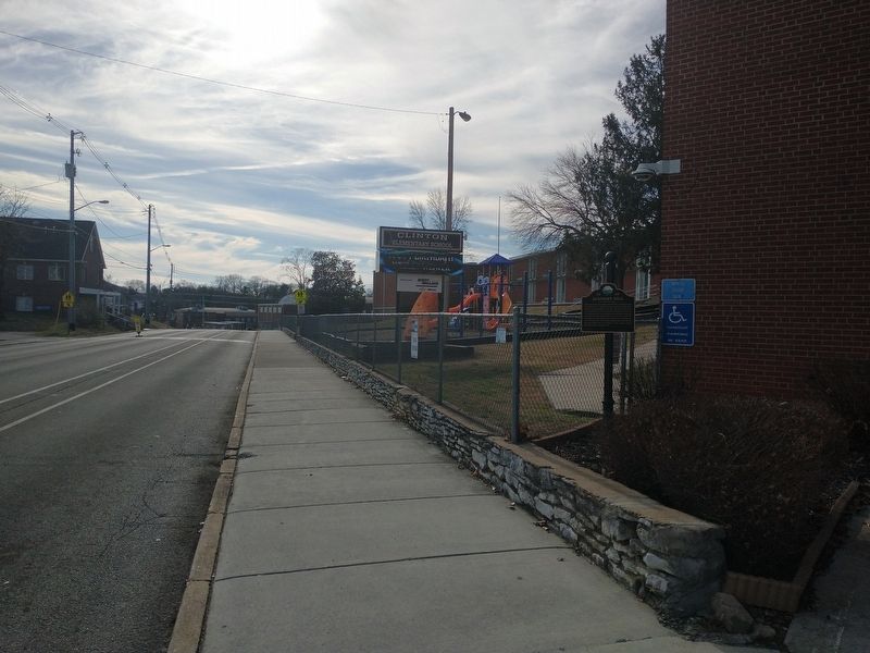
The structure currently home to Clinton Middle School was built in 1927 as the new Clinton High School. When Anderson County Schools took over operation of Clinton High School from Clinton City Schools in the mid 1920's, a new CHS was completed here . . . — — Map (db m215003) HM
On West Broad Street at Hillcrest Street, on the right when traveling west on West Broad Street.
A segregated elementary school for African American children existed on this hill since at least 1895. A wooden structure originally built here was replaced in 1935 by the current brick building. The school was renamed to honor Green L. McAdoo . . . — — Map (db m214990) HM
On North Main Street (U.S. 25W) at Cedar Street, on the right when traveling north on North Main Street.
Upset by segregationists who intimidated 12 African American pupils at Clinton High School who refused to return to classes, the Reverend Paul Turner, pastor of Clinton's First Baptist Church, met with the pupils on December 4. 1956, when he and two . . . — — Map (db m220585) HM
On Oak Ridge Turnpike (Tennessee Route 95) at South Tulane Avenue, on the right when traveling east on Oak Ridge Turnpike.
The need for good schools here posed special problems. The large transplanted population wanted schools at least as good as those they left behind, and the school population was destined to skyrocket from 830 in October 1943 to 8,223 in October 1945 . . . — — Map (db m112550) HM
The rapidly increasing population of Oak Ridge during the early 1940s led to a high demand for housing. At one point, homes within the Secret City were being completed every 30 minutes. Oak Ridge needed a school system to meet the educational needs . . . — — Map (db m215320) HM
On Oak Ridge Turnpike (Tennessee Route 95) at South Tulane Avenue, on the right when traveling east on Oak Ridge Turnpike.
In 1946, 14 southern universities formed the Oak Ridge Institute of Nuclear Studies (ORINS) – the first peacetime institution of this Secret City – to help faculty and students benefit from the outstanding research staff and facilities . . . — — Map (db m112344) HM
On South Tulane Avenue, on the right when traveling south.
At the same time the Government was starting large construction programs in 1948 to build permanent housing, work started to replace the hurriedly built wartime schools. The first permanent school finished was Willowbrook Elementary in September . . . — — Map (db m112459) HM
On Webb Road East (State Highway 82), on the right when traveling west.
Founded 1870, at Culleoka, by William R. ("Sawney") Webb, whose brother John M. ("Old Jack") Webb joined him in 1874. It moved here in 1886. Its curriculum, embracing chiefly Latin, Greek and Mathematics, was designed to give a sound preparatory . . . — — Map (db m24169) HM
On Upper East Valley Road (Tennessee Route 209), on the right when traveling south.
The Pikeville AME Zion Church is the oldest African-American church still operating in Bledsoe County. The core of the church building dates from about 1870 when it served as the Freedmen's Bureau school. The AME Zion congregation's use of the . . . — — Map (db m184534) HM
On Dayton Mountain Highway (State Highway 30) at Walker Road, on the right when traveling west on Dayton Mountain Highway.
(obverse)
Rhea County
Established 1807; named in honor of
John Rhea
Revolutionary veteran, who fought at King's Mountain. Delegate to the North Carolina Convention which ratified the U.S. Constitution; member of the Tennessee . . . — — Map (db m63645) HM
On William Howard Taft Highway (U.S. 127) at College Station Cross Road (State Road 110), on the right when traveling south on William Howard Taft Highway.
About 500 yds. NW. This school was the outgrowth of a community meeting at Bryant Camp Ground in 1858. War conditions delayed opening until 1865, with Prof. Gerry Rodgers first president. The first student body included both Confederate and Federal . . . — — Map (db m57953) HM
On Joule Street at Carrel Street, on the right when traveling east on Joule Street.
Bassel School was constructed in 1923 to provide a new school for children in the Bassel community. The new school was dedicated February 1, 1924. The school contained eight grades.
Captions (clockwise from top left)
• Bassel School . . . — — Map (db m195403) HM
On East Howe Street, 0.1 miles north of North Hall Road (Tennessee Route 35), on the left when traveling north.
Alcoa schools for black citizens played a vital role in the growth and development of Alcoa. From 1916 to 1926, classes were held in one-room buildings and on the top floor of the Commercial Building. The first building on this site was completed . . . — — Map (db m195398) HM
Near Dalton Street south of Alcoa Road, on the right when traveling south.
Alcoa High School began participating in athletics, as the Red Tornadoes, in the fall of 1924. The gymnasium was added in 1927. Alcoa High School played its home basketball games there until 1954.
Captions (clockwise from top . . . — — Map (db m195370) HM
Near Dalton Street south of Alcoa Road, on the right when traveling south.
Springbrook School was built in 1921 for grades 1-12, including, until 1939, Alcoa High
School. The school was the City's first major school construction project. Today's park
grounds lying between the concrete pad and the creek were the school's . . . — — Map (db m195367) HM
On West College Avenue close to North Farnum Street (Tennessee Highway 333), on the right when traveling west.
This village, 8 mi. W., was founded by a colony of Quakers from New Garden,
N. C., in the 1790's. The Newberry Meeting officially recognized it in 1808. The first Friends' organization in the county, it is the only one surviving. Friendsville . . . — — Map (db m150763) HM
March 2, 1793 – July 26, 1863
Born In Rockbridge County VA
Moved To TN in 1807
Taught At This Schoolhouse In 1812
Attended Porter Academy In 1813
Joined Army In 1813 In Maryville, TN
Studied Law In Nashville, TN In 1818
U.S. . . . — — Map (db m1733) HM
On E. Lamar Alexander Pkwy (Route 321), on the right when traveling east.
Founded in 1819 by the Synod of Tennessee, Presbyterian Church in the USA, as The Southern and Western Theological Seminary, its first president was Rev. Isaac Anderson, D.D. Its original buildings were on Broadway at College Street. Receiving its . . . — — Map (db m36993) HM
On West Broadway Avenue (Tennessee Route 411), on the right when traveling east.
Dedicated with great affection and esteem by former students to the memory of Professor Charles William ("Bill Joe") Henry (1878-1935) and Mrs. Leola Landon Henry (1884-1966). Married January 1904. Founders and operators of Maryville Polytechnic . . . — — Map (db m107920) HM
On Wildwood Springs Road at Wildwood Road, on the right when traveling east on Wildwood Springs Road.
Chartered in 1806. Opened in 1808. Occupied two Maryville sites from 1808 to the Civil War. Reopened at Wildwood in 1872 on a five acre tract donated by Thomas J. Pritchett and wife Mary. Academy land and buildings were deeded to Blount County in . . . — — Map (db m150839) HM
On West Broadway Avenue (U.S. 411) at West Lamar Alexander Parkway (U.S. 321), on the right when traveling north on West Broadway Avenue.
Dr. Samuel Pride, first Worthy Master of the New Providence Masonic Lodge, built his house here. Maj. Gen. W. T. Sherman, enroute to the relief of Burnside at Knoxville, billeted himself here. From 1878 to 1900 it was the Friends’ Normal Institute. . . . — — Map (db m58509) HM
On East Broadway Avenue (Tennessee Route 33) at East Lincoln Road, on the left when traveling north on East Broadway Avenue.
Three miles south is the school-house built in 1796 by Andrew Kennedy and Henry McCulloch for their children. Sam Houston taught here in 1811 or 1812. He later became Governor of Tennessee, Commander-in-Chief of the Texas Army, President of the . . . — — Map (db m109629) HM
On Wears Valley Road (U.S. 321) just north of Lamar Alexander Parkway (U.S. 321), on the right when traveling north.
This Irish patriot, exiled from his homeland for revolutionary newspaper activities, settled in the cove about two miles from here in 1855. After a short stay he moved to Knoxville. The rest of his life was taken up with lecture tours and newspaper . . . — — Map (db m56818) HM
On 2nd Street Southeast, 0.1 miles south of Linden Avenue Southeast, on the right when traveling south.
On this site in 1910, East Side School was constructed to serve as a three year City High School. The students then transferred to Bradley Central High School when it was completed in 1916. The school was renamed Allen Grammar School in honor of . . . — — Map (db m153740) HM
On North Ocoee Street (State Highway 74) just north of 22nd Street Northwest, on the left when traveling south.
On this site in 1916, Bradley Central High School began meeting the educational needs of
this community. Adopting its name from the county, which in turn was named in honor of Col. Edward Bradley, a veteran of both the Revolutionary War and the War . . . — — Map (db m153667) HM
On Berry Street Northeast just south of Central Avenue Northeast, on the right when traveling north.
On this site in 1883, the first local school building for African-Americans was erected. In 1890, the school awarded four diplomas at its first commencement. The wooden building was razed in 1924, and a new brick structure was built to house grades . . . — — Map (db m153738) HM
On 6th Street Northeast, on the right when traveling north.
In honor of
Darlia McLuhan Conn
Darlia McLuhan Conn served the university as the presidential spouse for 34 years, 1986-2020. During that time, she was an adjunct member of the piano faculty in the School of Music, and her presence and . . . — — Map (db m227448) HM
Built in 1967 to house male students for Lee College, Hughes Hall was razed in 2010 to create the Science and Math Complex quadrangle. — — Map (db m227450) HM
A building on this site housed the Lee College Music Department from 1947 to 1995; it was replaced by the current School of Music building on Parker Street. The building was two stories, a long rectangular structure with a single hallway from the . . . — — Map (db m227452) HM
On this site was an 850-seat auditorium with a balcony and large stage for theatrical productions. Built when Bob Jones College owned the campus, it was never given a name after Lee College bought the campus in 1947. (The auditorium had no bathrooms . . . — — Map (db m227451) HM
On North Ocoee Street (Tennessee Route 74) at Centenary Avenue NW, on the right when traveling north on North Ocoee Street.
Since 1885 this campus has been dedicated to the purposes of Christian higher education. Lee College was founded by the Church of God as Bible Training School on January 1, 1918, on Caut Avenue in Cleveland. The school relocated in Sevierville in . . . — — Map (db m49558) HM
On North Ocoee Street (State Highway 74) just north of 6th Street Northeast, on the left when traveling north.
Masonic Lodge No. 134 and the town of Cleveland established the Masonic Female Institute in 1848 and opened the school in 1856. At the beginning of the war, student and diarist Myra Inman wrote of a disruption in the school's leadership: "Mr. . . . — — Map (db m153687) HM
On Central Avenue NW at Oak Street NW, on the right when traveling east on Central Avenue NW.
Chartered Dec. 16, 1837, this was the first such institution in the Ocoee Purchase; here was its home during its entire existence. An early teacher (1843) was Henry von Aldehoff, a native of Prussia and graduate of Bonn University. This building was . . . — — Map (db m49559) HM
On Cherry Avenue at College Drive, on the right when traveling west on Cherry Avenue.
Founded as Bethel Seminary at McLemoresville in 1842 by the West Tennessee Synod, Cumberland Presbyterian Church, with Rev. Ruben Burrow principal. Incorporated in 1847, it became Bethel College in 1850 and moved here in 1872. It was presented to . . . — — Map (db m52842) HM
On Highland Drive (U.S. 79) 0.1 miles south of Tennessee Route 22, on the left when traveling north.
Originally founded in 1923 as the black "County Training School" at Smyrna, Tennessee. It was moved to McKenzie in 1927, and named "Webb High School" in honor of John L. Webb. With over 1900 alumni, this school, under the leadership of J. L. Seets . . . — — Map (db m52177) HM
On West College Street at Oak Street, on the right when traveling south on West College Street.
Near this site, in 1842, Bethel
College had its beginning as Bethel
Seminary, founded by the West
Tennessee Synod of the Cumberland
Presbyterian Church. The college
continued here in McLemoresville
until 1872, when it was moved to
McKenzie. . . . — — Map (db m194269) HM
On West College Street (Tennessee Route 105) at Church Street, on the right when traveling east on West College Street.
McLemoresville was settled in early 1800. In 1820 missionaries Rev. Benjamin Peeples and Rev. Lewis Garrett met at the Public Land Office to divide their territory. By 1859 a church was organized. From 1886 when the northern Methodist Episcopal . . . — — Map (db m194273) HM
On Academy Street, 0.1 miles south of Broad Street (U.S. 19E).
These stones are from the foundation of the academy established Sept. 13, 1806, with Maj. George Duffield, Chairman, Nathaniel Taylor, George Williams, Alexander Doran & John Greer, Trustees. In 1807, Andrew Taylor, Abraham Henry and Reuben Thornton . . . — — Map (db m46607) HM
On Milligan Highway (State Highway 359) at Blowers Boulevard (State Highway 2530), on the left when traveling south on Milligan Highway.
Buffalo Creek Christian Church organized here in 1830. In 1867 Buffalo Male & Female Institute was established by Rev. W.G. Barker on land given by Joshua Williams. Josephus Hopgood of Ky. purchased it in 1875, naming it Milligan College in 1882, . . . — — Map (db m157861) HM
Near Cedar Grove Road, 0.1 miles west of Milligan Highway (Tennessee Route 359), on the right when traveling north.
Not far from this spot stood the Milligan College Flag Stop, which from 1896 until 1934 provided shade and shelter for passengers who waited for the East Tennessee and Western North Carolina Railroad — the "Tweetsie" — to take them either west to . . . — — Map (db m184193) HM
On Governor Alf Taylor Road east of Country Garden Road, on the left when traveling east.
The Edmund Williams family, pioneers of
the area. owned the original log cabin at
this site. Owner Joshua Williams (1808-1895)
enlarged the house and in 1866 gave land
for Buffalo Institute. Now Milligan College,
it was established by Col. W. . . . — — Map (db m157849) HM
On Watauga Road (Tennessee Route 400) 0.1 miles west of Smalling Road, on the left when traveling west.
Range School was in operation prior to Oct. 29, 1843. It began as a common school with classes held in a log sheep barn donated by Jonathan Range. In 1901, a one-room frame building was constructed near the original site. A brick building was . . . — — Map (db m53528) HM
On New Hope Church Road, 0.1 miles west of Powers Drive, on the left when traveling west.
In 1885 J.T. Mosely deeded this property for use as a school or church for African Americans in the Neptune Community. To enhance the quality of public education for African Americans in rural Cheatham County, school officials built Neptune School . . . — — Map (db m151795) HM
On Tennessee 12 at Hazel Drive, on the right when traveling south on Tennessee 12.
Richard and Hazel Head moved their family to Cheatham County in 1966 so their daughter,
Pat, could play basketball. A 1970 graduate of Cheatham County Central High School and a
1975 graduate of the University of Tennessee-Martin, Pat played in the . . . — — Map (db m165476) HM
On North Vine Street, 0.1 miles north of Mulberry Street, on the right when traveling north.
The son of C. Hyde and Vina (Hale) Stump, Thomas Jefferson Stump was born in Cheatham County on February 18, 1870 and was educated in Cheatham and Dickson Counties. On October 27, 1895, he married Henrietta Dozier. They had two sons. Stump engaged . . . — — Map (db m151786) HM
On East Main Street, on the right when traveling east.
The campus includes the sites of predecessors Henderson Male and Female Institute (1869-1885), West Tennessee Christian College (1885-1897), Georgie Robertson Christian College (1897-1907), and National Teachers Normal and Business College . . . — — Map (db m84788) HM
Founded by Rev. & Mrs. A. A. Myers in 1890. First classes held in basement of Congregational Church on site of present Cumberland Gap School; later moved 1/2 mile west to Harrow Hall. Operated as a division of its successor, Lincoln Memorial . . . — — Map (db m80233) HM
This very memorable area, located just under the ridge from the Sanatorium of the Four Seasons Hotel, is part of the original campus. Being a small tract of land slightly rolling in nature, the area first lent itself to outdoor activities and . . . — — Map (db m151541) HM
On Mars-DeBusk Parkway at Hamilton Way, in the median on Mars-DeBusk Parkway.
During the Civil War, President Abraham Lincoln commented to General O. O. Howard that after the War ended, he hoped General Howard would do something for the people of this area. Years later, Howard would recall this exchange as he traveled through . . . — — Map (db m204563) HM
On University Boulevard (Mars-DeBusk Parkway), on the right when traveling west.
Cumberland Gap became the principal passage between the eastern and western theaters of operation in the Upper South during the war. Whichever side held the high ground here held the Gap.
In 1861, Confederate Gen. Felix K. Zollicoffer's men . . . — — Map (db m35761) HM
On Cumberland Gap Parkway (U.S. 25E), on the left when traveling north on Cumberland Gap Parkway.
"If you come through this misery alive... I want you to do something for all those mountain people who have been shut out of the world all these years." These words of President Abraham Lincoln to General O. O. Howard in 1863 proved to be the . . . — — Map (db m35760) HM
Near NE Atlantic Street north of East Lincoln Street, on the left when traveling north.
Tullahoma, chartered in 1852, was laid out by a Town Company along the Nashville and Chattanooga Railroad line being built at the time. The street along the railroad was named “Atlantic” perhaps because the railroad made possible an . . . — — Map (db m172367) HM
On Bells Street (Tennessee Route 88) at South Court Street, on the right when traveling north on Bells Street.
Robert H. "Bob" White was born in Crockett County 10 miles west of this site. He served 15 years as Tennessee's first official State Historian. He had previously served as a college teacher and a consultant to many departments of state government as . . . — — Map (db m52977) HM
On College Street west of East End Street, on the right when traveling west.
The Maury City Masonic Lodge #368. Chartered January 1,1911 by the Grand Lodge of the State of Tennessee Free and Accepted Masons. made its home in the third floor of the old Crockett High School building which once stood on these grounds until its . . . — — Map (db m207478) HM
On Old Jamestown Highway at Methodist Campground Drive, on the left when traveling north on Old Jamestown Highway.
Reverend Robert Hershey Hall walked over this county
serving an eight church circuit. His intercession in
behalf of many young people who were being denied
the opportunity for education led to the establishment
of Cumberland Mountain School by . . . — — Map (db m150211) HM
On East Main Street west of Maryland Road, on the left when traveling west.
Pleasant Hill Was incorporated in 1903. Pleasant Hill Academy, a secondary school, was founded here in 1884 by the American Missionary Association of the Congregational Churches to provide an education for the young people of the Cumberland Plateau. . . . — — Map (db m69229) HM
On Blairfield Drive, on the right when traveling east.
Nashville barber Alfred Z. Kelley was lead
plaintiff in Kelley v. Board of Education, a federal lawsuit filed Sept. 23. 1955, on behalf of his son Robert and 20 other African American
children. In December, the suit was amended
to include two . . . — — Map (db m146420) HM
On Cane Ridge Road, 0.4 miles north of Old Hickory Boulevard, on the right when traveling north.
In 1871, District 6 school commissioners John Briley, Benjiah Gray and Jason Austin bought one acre of land from James Thompson for an African American school. In 1873, African American members of the Benevolent Society of Olive Branch No. 38 . . . — — Map (db m147704) HM
On McGavock Pike at Stones River Road, on the left when traveling north on McGavock Pike.
Built in 1859 by David H. McGavock, this mansion stands on land inherited by McGavock's wife, Willie, from her father, William Harding. The smaller house to the left was built in 1802. Dr. James Priestley's Academy, established about 1816, was . . . — — Map (db m147569) HM
On Chandler Road, 0.1 miles north of Summit Run Place, on the right when traveling north.
As early as 1815, school was held nearby at Stoner's Lick Methodist Church. In 1843, early settler Timothy Dodson granted land for a dedicated schoolhouse that was built c. 1855. After it burned, classes were held at the Hermitage railroad station . . . — — Map (db m147673) HM
On Cheyenne Boulevard, 0.1 miles north of Pallas Drive, on the right when traveling north.
In June 1904 near this spot, "The Morning Star" moored for repairs. Seventh-day Adventist visionary Ellen White, mother of boat owner Edson White, saw the nearby Ferguson Farm for sale and told educators Edward A. Sutherland and Percy T. Magan to . . . — — Map (db m162447) HM
On Hospital Drive, 0.1 miles north of Neelys Bend Road, on the left when traveling north.
Madison College was founded in 1904 as Nashville Agricultural Normal Institute by Seventh-day Adventists on a farm of 412 acres. A sanitarium and campus industries were integral to the plan of work and study for students training for careers in . . . — — Map (db m147701) HM
On Post Road at Davidson Road, on the right when traveling south on Post Road.
In 1910, Horace Greeley Hill, Sr. and wife Mamie began buying land around their West Nashville home Cliff Lawn. After Hill Sr., an entrepreneur and philanthropist, died in 1942, H.G. Hill, Jr. took over the family business and began developing that . . . — — Map (db m147414) HM
On Doctor Walter S Davis Boulevard, on the right when traveling south.
The total height of the TSU Olympian is 46 feet. It is constructed
using the slip roller technique, a process that allows an artist to
bend sheets of metal at incremental degrees between rollers.
Jane-Allen McKinney, Assistant Professor of Art at . . . — — Map (db m209506) HM
On Nolensville Pike (Alternate U.S. 41) 0.1 miles north of Strasser Drive, on the right when traveling north.
On the site of this house was home of John Haywood, a Supreme Court Justice in North Carolina. Founder (1820) of the Antiquarian Society, forerunner of the Tennessee Historical Society and author of the basic histories of the state, he is known as . . . — — Map (db m182312) HM
On West Heiman Street at Ed Temple Boulevard, on the right when traveling west on West Heiman Street.
J. Frankie Pierce was born during or shortly
after the Civil War. In 1921, she founded the
Tennessee Vocational School for Colored Girls
and served as its first superintendent until 1939.
The founding of this school was aided by the
Negro . . . — — Map (db m166306) HM
On Robertson Academy Road, 0.2 miles west of Franklin Pike (U.S. 31), on the left when traveling west.
Was established by an Act of the
Tennessee General Assembly Sept. 13,
1806, which provided for an academy
in each of the then 27 counties.
The school has operated continuously since that time. — — Map (db m151594) HM
On Centennial Boulevard/John A Merritt Boulevard, on the left when traveling east.
Established in 1912 for the education of Negro citizens, Tennessee State University merged with UT-Nashville in 1979 and has become a major comprehensive urban university. Development from normal school to university progressed as follows: Tenn. A & . . . — — Map (db m5512) HM
Tennessee Agricultural & Industrial State Normal School for Negroes first opened its doors to 247 students in 1912. This site gave birth to a new era of public higher education for African Americans in the state of Tennessee, with emphasis on . . . — — Map (db m182179) HM
On Blue Hole Road, 0.3 miles south of Antioch Pike, on the left when traveling south.
Antioch High School opened here in the fall
of 1933, after community members from Antioch,
Cane Ridge and Mims (Bakertown) signed
petitions to the Board of Education urging them
to choose Antioch, not Una, as the school
location. Previously the . . . — — Map (db m224208) HM
On Leake Avenue at Park Hill Drive, on the right when traveling west on Leake Avenue.
In 1927 8.25 acres of the Belle Meade Plantation were acquired from its owner Walter O. Parmer to use for a new school. Parmer School opened that fall as a one-room school with grades 1-3. In 1928 the school was transformed into a modern brick . . . — — Map (db m147103) HM
On Harding Road (U.S. 70S) at Cherokee Road, on the right when traveling east on Harding Road.
Formally established in 1867 with a bequest of $20,000 by ironmaster Montgomery Bell, the roots of M.B.A. actually go back to 1785, with the University of Nashville, Cumberland College, and Davidson Academy. The boy's preparatory school has been . . . — — Map (db m147170) HM
On 1st Avenue South just south of Mildred Shute Avenue, on the right when traveling south.
Built about 1921 from donations of Meharry Medical College alumni and trustees, Hubbard House served as the retirement home of Dr. George W. Hubbard, a founder and head of Meharry for 44 years. Listed on the National Register of Historic Places due . . . — — Map (db m147543) HM
On 1st Avenue South just south of Crenshaw Street, on the right when traveling north.
Lieutenant Henry Alvin Cameron (1875-1918). Henry A. Cameron was born on February 4, 1875 to Walter and Jane Bentley Cameron. He attended Pearl Grammar School and completed the eighth grade in 1889. During the academic years of 1905 and 1906, . . . — — Map (db m166378) HM
Erected in 1890 and named for Ireland's patron saint, this Second Empire style church was built to serve South Nashville's growing Irish Catholic population. Until 1954, the Sisters of Mercy taught a grade school here. Since the 1890s, the Irish . . . — — Map (db m74367) HM
On Hogan Road, 0.1 miles east of Trousdale Drive, on the left when traveling east.
The Crieve Hall neighborhood was part of the over 2,000-acre estate of John Overton, on which he built Travellers Rest in 1799. Jesse M. Overton built an English Tudor-style house called Overton Hall near here in 1900. Mr. and Mrs. Herbert Farrell . . . — — Map (db m147409) HM
On McGavock Pike at Cumberland Trace, on the right when traveling south on McGavock Pike.
On the present site of Two Rivers High School, Belmont Domestic Academy, a girl's boarding school was founded in 1815. It was conducted by Mr. and Mrs. John J. Abercrombie in a large frame house formerly the residence of David Buchanan. Among the . . . — — Map (db m151771) HM
Near 3rd Avenue North north of Union Street, on the right when traveling north.
One of the last remaining buildings on the Square, 206 Public Square was home to the African Methodist Episcopal Church Sunday School Union beginning in 1886, when Rev. Charles S. Smith purchased the building. The A.M.E. Sunday School Union, . . . — — Map (db m206241) HM
On Charlotte Avenue just west of YMCA Way, on the left when traveling west.
A native of Knoxville, Tennessee, Avon N. Williams, Jr., was an attorney, statewide civil rights leader, politician, educator, and a founder of the Davidson County Independent Political Council and the Tennessee Voters Council. In 1950, as a . . . — — Map (db m147486) HM
On Broadway (U.S. 70) at 7th Avenue North, on the right when traveling west on Broadway.
On this site was erected, in 1853, Nashville's first public school building, named in memory of Alfred Hume, an eminent educator, and known as the “Father of the Nashville public school system.”
On this spot was the site of a building . . . — — Map (db m166566) HM
Nashville's first public school, Hume School, opened here Feb. 26, 1855. A three story brick building, the school employed 12 teachers and served all grades. In 1874 high school classes were moved to Fogg School built on adjoining corner lot. Named . . . — — Map (db m28468) HM
On 3rd Avenue North, on the right when traveling north.
The Seeing Eye, the world-famous dog guide training school, was incorporated in Nashville January 29, 1929, with headquarters in the Fourth and First National Bank Building at 315 Union St. Morris Frank, a 20-year-old blind man from Nashville, and . . . — — Map (db m61940) HM
On Rosa L. Parks Boulevard (U.S. 31) south of Church Street, on the right when traveling south.
Ward's Seminary for Young Ladies, founded in 1865 by Dr. William E. Ward, stood at this
site many years. Ward, a graduate of Cumberland University in both law and divinity, died in 1887. The school was sold, but continued to operate as Ward's . . . — — Map (db m166495) HM
On Ramsey Street just west of North 8th Street, on the right when traveling west.
Named in honor of James L. Meigs, Nashville's second superintendent of public school. Meigs was established in 1883 as an elementary school for African-American students. An African American, Robert S. White, served as its first principal. Since . . . — — Map (db m175905) HM
On Ann Street at Rock City Street, on the right when traveling west on Ann Street.
Rock City was an African American community established c. 1881, which was soon followed by the founding of First Baptist Church Rock City. Named for a rock quarry in the area, the approx. boundaries were Cahal Ave. to the south, Branch St. to the . . . — — Map (db m147714) HM
On Gallatin Pike north of Gwynn Drive, on the right when traveling north.
This institution of learning was erected on part of a tract of land once owned by Isaac Litton. He was the grandfather of Litton Hickman, Judge of Davidson County from 1918 to 1950. Named in honor of both, the school formally opened on October 25, . . . — — Map (db m151764) HM
On 8th Avenue South (U.S. 31) at Chestnut Street, on the right when traveling north on 8th Avenue South.
Fall School, built in 1898, is the oldest public school building remaining in Nashville. Named after Mr. P.S. Fall, a prominent Nashville businessman and member of the Board of Education from 1865-1867, it served as an elementary school until 1970. . . . — — Map (db m147507) HM
The Academic Building at Fisk University was designed by Nashville architect Moses McKissack and was made possible by a gift from philanthropist Andrew Carnegie. On May 22, 1908, William H. Taft, later 27th President of the United States, laid the . . . — — Map (db m4511) HM
This neo-Gothic structure first served as the Erastus M. Cravath Memorial Library. Named for Cravath, the university's first president (1875-1900), it was designed by Nashville architect Henry Hibbs and built in 1929-30. The interior walls depict . . . — — Map (db m4502) HM
On 17th Avenue North north of Meharry Boulevard, in the median.
In 1871 Fisk University, established for emancipated African Americans in 1866, faced closure due to financial exigency. George Leonard White, the school's treasurer and music teacher, organized a small choral group composed of student singers, . . . — — Map (db m151700) HM
On Dr. D. B. Todd, Jr. Blvd. at Jackson Street, on the right when traveling north on Dr. D. B. Todd, Jr. Blvd..
Fisk University, founded in 1866 by the American Missionary Association, was chartered in 1867 to provide higher education for men and women regardless of race. Named for General Clinton B. Fisk, assistant commissioner of the Freedman's Bureau for . . . — — Map (db m4510) HM
On Jackson Street, on the right when traveling east.
Born a slave in Madison County, Samuel McElwee began teaching school in Haywood County at the age of 16. In 1882, he was elected to the Tennessee House of Representatives and one year later was graduated from Fisk University. The only African . . . — — Map (db m81465) HM
Talley-Brady Hall was named for well-known African-American chemists Thomas Talley and Saint Elmo Brady, both graduates of Fisk University. Talley was chairman of the chemistry department from 1902 to 1927. In 1916 Saint Elmo Brady was one of the . . . — — Map (db m4503) HM
On 17th Avenue North at Phillips Street, on the right when traveling north on 17th Avenue North.
This Italianate structure was built ca. 1876 as the home of Richard Harris, an entrepreneur and owner of Harris Furniture Co. In the late 1880s, he became the first Black trustee of Fisk University. W.G. Waterman, a Fisk professor, became owner of . . . — — Map (db m4501) HM
629 entries matched your criteria. The first 100 are listed above. Next 100 ⊳