On Bayview Avenue at West 11th Street, on the right when traveling north on Bayview Avenue.
The land was purchased during the 1886 "land boom" when the St. Andrews Bay RR Land & Mining Company sold this lot for $9. The home was constructed shortly thereafter and housed the J.R. Thompson Store from 1901 - 1915, Over the years the property . . . — — Map (db m245550) HM
On NW 151st Boulevard near NW 142 Terrace, on the right when traveling east.
Upon completion to Gainesville of the Savannah, Florida and Western Railway in May 1884, citizens from the former county seat at Newnansville were among those who moved to the present site of Alachua which was near the railroad. The city is located . . . — — Map (db m65458) HM
On Main Street at NW 150th Avenue, on the right when traveling south on Main Street.
City of Alachua Downtown Historic District has been placed on the National Register of Historic Places in 2000 by the United States Department of the Interior — — Map (db m239993) HM
On SW 134th Avenue near SW 132nd Lane, on the right when traveling west.
When Europeans first arrived in this area in the 16th century, the inhabitants were Timucuan Indians. In 1774, traveling botanist William Bartram visited Seminole Indians nearby. In the 1850's a town called Deer Hammock was established here, . . . — — Map (db m69979) HM
On SW 134th Avenue at SW 170th St, on the right when traveling west on SW 134th Avenue.
Side 1
David Levy Yulee was born at St. Thomas, West Indies, in 1810. He attended school in Virginia from 1819 until 1827 when he went to Micanopy to work on one of the plantations of his father, Moses Elias Levy. He studied law and was . . . — — Map (db m97513) HM
On County Road 225, on the right when traveling north.
Evinston Community Store and Post Office
The Evinston community store, originally a warehouse, was built of heart pine in 1884 by W.P. Shettleworth. it was bought by Joseph Wolfenden, who first operated it as a store. The post office, . . . — — Map (db m54240) HM
On NE Waldo Road (State Road 24) near NE 65th Terrace, on the right when traveling west.
The naval stores industry was important to maritime power worldwide. Pine tar and pitch were used to seal wooden ships and protect sails and rigging. When settlers came to America - in Florida (1565), in Virginia (1607) and in Massachusetts . . . — — Map (db m166815) HM
On Gale Lemenard Drive, 0.1 miles south of West University Ave (State Road 26), on the right when traveling south.
Gatorade, the sports drink that started an industry, was invented at the UF College of Medicine by a team of researchers led by Dr. Robert Cade. Gatorade was first field tested in a football scrimmage near this site and was first used in an October . . . — — Map (db m120371) HM
Near Union Road at Murphree Way, on the right when traveling east.
Linton Elias Grinter served as the Dean of the Graduate School and Director of Research from 1952 until 1969. He received his doctoral degree in civil engineering from the University of Illinois in 1926 and had a distinguished career as a . . . — — Map (db m151283) HM
Near SW Williston Road (State Road 331) 0.1 miles west of SW 13th Street (U.S. 441).
(side 1)
In 1857, David Rogerson Williams II (1822-1907) of Darlington Co., SC, purchased 1,000 acres, including this site bordering Paynes Prarie, and developed them as a plantation known as "Serenola." The 1860 census shows 120 slaves . . . — — Map (db m67687) HM
On E. University Avenue, on the right when traveling west.
Present-day Gainesville was the center of a large Spanish cattle ranching industry, founded on the labor of native Timuqua Indians, during the 1600s. LaChua, largest of the ranches, was a Spanish corruption of an Indian word, and in turn was . . . — — Map (db m72916) HM
On Fletcher Drive south of West University Drive (Florida Route 26), on the right when traveling north.
When this building opened in 1906, it was called the Main Building. It served as the administration-classroom building for the University. The president’s office was on the southwest corner of the first floor. There were twenty-four classrooms, . . . — — Map (db m151217) HM
On NE 6th Ave at NE 4th St, on the left when traveling east on NE 6th Ave.
William Ruben Thomas House begun by C.W. Chase in 1906, this building was bought and completed in 1910 by Major W.R. Thomas, the house continued as the family’s residence until 1926 when it became part of the Hotel Thomas. Its use by the citizens . . . — — Map (db m150663) HM
On State Road 121 at State Road 235, on the right when traveling north on State Road 121.
Settlement in the LaCrosse area started in the 1840s with the arrival of John Cellon, a young French immigrant. Other early settlers were Thomas Green, Abraham Mott, Richard H. Parker and family, William Scott and Thomas Standley. The town was built . . . — — Map (db m93838) HM
On State Road 121 at State Road 235, on the right when traveling north on State Road 121. Reported permanently removed.
The LaCrosse area was settled before the Civil War. Cotton was the chief crop. John Eli Futch was a cotton buyer who built a warehouse for cotton, a store to serve the growers, and his home near the store. This store became the first post office and . . . — — Map (db m220546) HM
On NE 1st Street (County Road 25A) near N.E. Peach Avenue, on the right when traveling west.
Founded after Spain relinquished Florida to the United States in 1821. Micanopy became the first distinct American
town founded in the new US territory. Originally an Indian trading post, Micanopy was built under the auspices of the
Florida . . . — — Map (db m54271) HM
Near NE Cholokka Boulevard at NE Bay Avenue, on the right when traveling north.
1884 “Gainesville, Rocky Point & Micanopy Railway” chartered
1895 RR company sold to L.L. Hill, renamed “The Gainesville and Gulf Railway Company”; construction began in July. Later in 1895 the RR from Gainesville to Micanopy opened (12 . . . — — Map (db m175527) HM
On NE Cholokka Boulevard at Northeast Magnolia Avenue, in the median on NE Cholokka Boulevard.
Moses Elias Levy (1782-1854), a Moroccan born Jewish merchant, came to Florida after its cession from Spain to the United States in 1821. Before his arrival, Levy acquired over 50,000 acres in East Florida. In 1822, Levy began development on . . . — — Map (db m93854) HM
On NE Cholokka Boulevard north of SE Tuscawilla Road, on the right when traveling north.
Built 1853 by Dr. James A. Cooper as first apothecary shop. Later became the stagecoach stop and first post office. Old stage route entered Micanopy from west on present Seminary Street. First telephone office was also here.
Placed by . . . — — Map (db m175405) HM
Near Northeast Cholokka Boulevard at Northeast Bay Avenue, on the right when traveling north.
Among the refreshing drinks Pharmacist Caleb Bradham of New Bern, NC, created for the customers at the soda fountain in his drugstore was his most popular “Brad’s drink” made of carbonated water, sugar, vanilla, rare oils, pepsin and . . . — — Map (db m175562) HM
On Old Bellamy Road, 0.2 miles west of Northwest 173rd Road Street, on the left when traveling west.
Side 1
Country stores were critical for collecting farm crops and sending them to market. They played an important role in building commerce and establishing credit. The Traxler store was one of several in Alachua County that provided these . . . — — Map (db m197954) HM
Near South Lowder Street south of West Railroad Avenue, on the right when traveling south.
When Alvarado A. Geitgey (pronounced Get-gee) moved to Baker County, he became legendary. A self-made prosperous and shrewd business man purchased large tracts of land in the area and began pecan groves, grape orchards, citrus groves and a dairy . . . — — Map (db m206585) HM
Near South Lowder Street south of West Railroad Avenue, on the right when traveling south.
Sadie & Corbett
"I was called Sugar Toes the first 7 years of my life until my Uncle Noah & Cousin Werth came riding up on a mule & asked daddy, "Dennis have you got a name for that boy yet?" My daddy said "Nope"! "Well, I got a name for him, . . . — — Map (db m206676) HM
B- July 17, 1896 — D- May 31, 1964
Graduate of Emory University Medical School, Atlanta, GA.
Organized Florida National Bank of Starke in late 1930’s
Baker County Physician 1920’s through 1940’s
Remembered by . . . — — Map (db m206570) HM
On South Lowder Street, 0.1 miles south of W Railroad Avenue.
Elisha Greene arrived in Baker County on Christmas Day in 1830, leading the first wagon train of pioneer settlers.
Acting as advance scouts were William and Mose Barber, and other men acting as scouts.
Others traveling in the train were the . . . — — Map (db m206950) HM
Near South Lowder Street near West Railroad Avenue.
Ida Estelle Corbett born September 8, 1860 was the daughter of Charles C. Corbett and his wite Zilphia Crowningshield, natives of Vermont. A stone cutter and funeral director by trade, Charles, moved his family to the area now known as Baker County . . . — — Map (db m206911) HM
Near South Lowder Street, 0.1 miles south of W Railroad Avenue.
Interview 1993
Olustee Friends A.G. St. Johns and Vonceil (Dobson-Fraser) Alvarez
Introduction: Olustee was once a fort during Florida's territorial days as well as a Methodist sanctuary mission. It was once a bustling, busy . . . — — Map (db m206757) HM
(Left side text) During the Great Depression, President Roosevelt approved a plan to recruit thousands of unemployed young men
into a "Civilian Conservation Corps" (CCC)
From 1933-1942 the CCC employed over 3 million Americans. They . . . — — Map (db m55674) HM
Near Interstate 10 at milepost 318,, 0.6 miles west of 17 Mile Camp Road, on the right when traveling east.
Did you know the first people in North Florida lived here 10,000 years ago?1562
Timucuans
The Timucuans were the Native Floridians living in north and central Florida when the Europeans arrived in 1562. Powerful and . . . — — Map (db m159960) HM
On U.S. 98 at Canal Parkway, on the right when traveling east on U.S. 98.
Built in 1919 for the British Navy, this 170-foot steamer originally was christened Kilmarnock. Admiral Richard E. Byrd purchased the ship for use in his Antarctic expedition of 1928-30 and renamed her Eleanor Bolling in honor of . . . — — Map (db m73753) HM
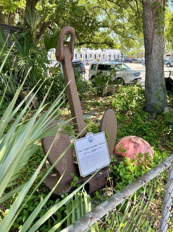
On West 11th Street east of Beck Avenue, on the right when traveling east.
Road and bridge construction during the Roosevelt administration of the 1930's made automobile travel easier and more common. In Florida, tourists stayed in "motor courts" like this one. C. M. Kelly owned several properties and businesses including . . . — — Map (db m245331) HM
On Harrison Avenue at East Beach Drive, on the left when traveling south on Harrison Avenue.
The first brick building in Panama City was completed in 1911 and housed Panama City's first bank. The bank closed in 1915 and was occupied by various businesses over the years. In 1941 Leslie Miller Gilbert opened Less Gilbert's Bay Shore Bar and . . . — — Map (db m245134) HM
On North Center Avenue south of East 2nd Plaza, on the right when traveling south.
This one-story house originally sat on the curve of E. Hwy. 98 across from the "Martin House." It was built circa 1911 by the Moore Timber Company and used as one of the many homes for those employed at the big sawmill operation from 1910-1922. It . . . — — Map (db m245437) HM
On Harrison Avenue south of East 4th Street, on the right when traveling north.
After a fire and explosion destroyed the Panama Motor Co. building on this site in 1930, W. J. Cook and wife Estelle, sister of former owner Fred T. Bennett, had erected the new Cook Motor Co. The large building had, from left to right, a display . . . — — Map (db m245255) HM
On Beck Avenue (Florida Route 30) south of West 14th Street, on the right when traveling north.
This fast food ice cream and hamburger shop was established by Harold L. & Dorothy Dunton. Tastee-Freez was one of the first soft serve franchises in the Nation. Subsequent owners included Mrs. Roberta Elder, Dana E. Wright and Galen Mielke. In . . . — — Map (db m245505) HM
On Harrison Avenue south of East 4th Street, on the right when traveling north.
This building housed the first "photo play theater" to open successfully in the Downtown. The 30 foot by 100 foot building was constructed on steel lath with stuccoed exterior. The owner and manager, J. Arthur Smith, had opera chairs installed that . . . — — Map (db m245247) HM
On West Beach Drive at Balboa Avenue, on the right when traveling west on West Beach Drive.
(side A)
Built in 1927 by A.A. Payne, a banker, and bought by John Christo, Sr., the house is significant in architecture, a mixture of styles typical of the late 19th and early 20th centuries which includes Neo-Colonial Revival and . . . — — Map (db m42117) HM
On Martin Luther King Jr Bpulevard (Florida Route 77) at East 11th Street, on the right when traveling south on Martin Luther King Jr Bpulevard.
Lee's Gulf Service Station which later changed to Lee's BP was owned by Edward Lee, Sr. This was a very successful business and allowed both blacks and whites to purchase fuel and associated supplies within the community.
Dan Lee says, "Each . . . — — Map (db m245081) HM
On Harmon Avenue at East Second Street, on the left when traveling north on Harmon Avenue.
Joseph Sihelnik bought this vacant property in 1932 and built a combination store and dwelling on the land to be used by his niece, Miss Maggie Slicho. The store was sometimes known as Cove Grocery and was operated by Maggie until 1948 when it was . . . — — Map (db m245203) HM
On Airport Road (County Road 391), on the left when traveling west. Reported missing.
Established 1945 on Fannin Field Panama City-Bay County Airport 1964 Panama City-Bay County Airport and Industrial District 1967 Developed and controlled by Representative Airport Authorities in conjunction with the Federal Aviation Agency Control . . . — — Map (db m221885) HM
On Beck Avenue at West 11th Court, on the left when traveling south on Beck Avenue.
Constructed by George M. West, one of the "founding fathers" of Panama City, it was at this site that Mr. West and his wife Lillian Carlisle West "Miss Lillian" published three local newspapers, numerous books and promotional materials for economic . . . — — Map (db m245045) HM
On East 3rd Court at Park Street, on the right when traveling west on East 3rd Court.
(Front Side): The McKenzie House is a large two-story clapboard frame dwelling built in the Dutch Colonial style typical of the turn of the century houses still standing in Northern Michigan. It was built 1909 by Belle Booth who married R. . . . — — Map (db m8155) HM
On Martin Luther King Jr Boulevard (Florida Route 77) south of 11th Court, on the right when traveling south.
After moving to Panama City Florida in late 1947 Morise and Clera opened Russ Shoe Shop at 1107 Cove Blvd. in 1949. Their shoe repair business was to become a pillar of the Glenwood community. About 1960, the Russ family built a new building next . . . — — Map (db m245084) HM
On College Avenue at East 3rd Street, on the left when traveling south on College Avenue.
This one and a half story frame house was built by the St. Andrews Bay Lumber Company in 1922 on the site of the "Old School Property at Millville". The school was operated from 1908 to 1917 by the Board of Public Instruction of Washington and Bay . . . — — Map (db m245457) HM
On Spring Avenue, 0.1 miles south of East 4th Street, on the right when traveling south.
This one-story cottage was built by the Moore Timber Co. at Bay Harbor about 1911 and was the residence of two of Bay County's early physicians, Dr. James C. Jones (1912 - 1919) and Dr. James Montgomery Nixon (1919 - 1925). Both were employed by the . . . — — Map (db m245435) HM
On Harrison Avenue, 0.1 miles north of East 4th Street, on the right when traveling north.
On November 16, 1936, Fred Moon of Moon Jewelry moved into this recently constructed building, owned by A.H. Brake at 424 Harrison Avenue. He was reputed in the 1930's to be the only certified watchmaker in town.
In 1943, Cecil M. Williams is . . . — — Map (db m245257) HM
On Harrison Avenue, 0.2 miles south of East Beach Drive, on the right when traveling south.
In 1936, the Van Kleeck Company, a hardware store, moved into two of the units of his new building, built by Deeb Construction Company. Panama Recreation Parlor opened in the unit at 131 Harrison Avenue. The most newsworthy event that occurred here . . . — — Map (db m245136) HM
Near East 4th Street at Harrison Avenue, on the right when traveling east.
This building was built in 1926 and named for its original owner, Walter L. Folkes, who introduced electricity to Panama City in 1915. The first floor was originally occupied by Panama Light and Power Company, under the management of Folkes' son, . . . — — Map (db m245238) HM
On East Call Street (Florida Route 230) just east of South Walnut Street, on the right when traveling east.
Bradford County Bank Built c. 1914 has been placed on the National Register of Historic Places by the United States Department of the Interior — — Map (db m169900) HM
Near Dave Nisbet Drive, 0.2 miles west of George J. King Boulevard, on the right when traveling west.
Port Canaveral is one of the busiest cruise ports in the world. Millions of passengers pass through the terminals every year on their way to relaxation and adventure. Some cruise liners are homeported here. For others, this is a port of call. . . . — — Map (db m164415) HM
On Lighthouse Road north of Control Tower Road, on the left when traveling north.
Beginnings of Settlement
In the 1500s European explorers, slavers and missionaries first came to Cape Canaveral. Here they found a Native American population which had disappeared by 1730. The area remained sparsely populated until a . . . — — Map (db m217567) HM
Near Dave Nisbet Drive, 0.2 miles west of George J. King Boulevard, on the right when traveling west.
Port Canaveral began as a small oil and fishing port. Today, the first-class, deep-water harbor can serve import, export and other industries. Through the years, generations of fishing families have taken their daily catch to market. Some of the . . . — — Map (db m164411) HM
On Glen Cheek Drive at Dave Nisbet Drive, on the right when traveling west on Glen Cheek Drive.
1964 – First cruise ship visit, S/S Yarmouth
1980 – First Queen Elizabeth II visit
1982 – First Cruises to Nowhere, S/S Scandinavian Seas
1984 – First homeported ship, Premier Cruise Lines S/S . . . — — Map (db m59645) HM
On Glen Cheek Drive, 0.3 miles west of Flounder Street, on the right when traveling west.
1953 – Commercial fishing began
1954 – First oil imported for Central Florida power plants
1955 – First merchant ship, S/S Mormac Spruce arrived
1962 – First bulk cement silos built
1966 – First . . . — — Map (db m59647) HM
On Glen Cheek Drive, 0.2 miles west of Flounder Street, on the right when traveling west.
1961 – Freedom 7, First space capsule recovered through the Port
1989 – Foreign Trade Zone (FTZ) 136 activated
1989 – First quadramodal connection between sea, land, air and space
1992 – SPACEHAB, First FTZ . . . — — Map (db m59648) HM
On Glen Cheek Drive, 0.3 miles west of Flounder Street, on the right when traveling west.
North Side Development
1971 – Courageous, First Coast Guard Cutter, arrived
1974 – First warehouse built
2000 – Container Yard completed
South Side Development
1965 – First refrigerated . . . — — Map (db m59665) HM
On Glen Cheek Drive, 0.4 miles west of Flounder Street, on the right when traveling west.
1968 – Jetty Park Opened
1990 – Central Park (renamed Freddie Patrick Park) opened
1992 – First Florida deepwater port to develop an Inlet Management Plan
1995 – Malcolm E. McLouth Fishing Pier dedicated
1995 . . . — — Map (db m59666) HM
On Glen Cheek Drive at Flounder Street, on the right when traveling west on Glen Cheek Drive.
Port dedicated by U.S. Senator Spessard L. Holland. Serving on the Canaveral Port Authority Board of Commissioners: Colonel Noah Butt, Chairman; David S. Nisbet; L.M. Carpenter; A.A. Dunn and G.W. Laycock. N.M. Argabrite, Secretary. Barbara . . . — — Map (db m59729) HM
On Delannoy Avenue at West King Street (Florida Route 520), on the right when traveling north on Delannoy Avenue.
(side one) Founded in 1885, the S.F. Travis Company is the oldest continuously operating business in the city of Cocoa and one of the oldest hardware stores in Florida. Surviving two world wars, numerous hurricanes, and financial busts, the . . . — — Map (db m145953) HM
On 4th Avenue at North Miramar Avenue (State Road A1A), on the left when traveling east on 4th Avenue.
The Indialantic Casino was constructed on this site in 1923. The two-story Mediterranean Revival style building was designed by architect William Christen and developed by Herbert Earle. It opened on December 22, 1923, and boasted shops, an . . . — — Map (db m81316) HM
On East Strawbridge Avenue (U.S. 192) at Riverview Drive NE, on the left when traveling east on East Strawbridge Avenue.
The first Carleton Hotel was built on this site about 1887, under the ownership of Jennie and Emma Strawbridge, sisters, who were natives of Sharon, PA.
That hotel burned in 1904. At the same time, the Idlewylde Hotel to the north, also burned. . . . — — Map (db m73120) HM
The First State Bank building was open for business on the south side of Eau Gallie Boulevard in 1883. One day in 1896, the cashier of the First State Bank was seen boarding a northbound train with two large suitcases. He was never heard from again, . . . — — Map (db m48990) HM
On Highland Avenue at Law Street, on the left when traveling north on Highland Avenue.
The three story building on the corner of Law and Highland was built by the Gleason family in 1910. The third floor was the Masonic temple. The building was built on some of the highest ground in the area and still had an artesian well with enough . . . — — Map (db m48982) HM
On New Haven Avenue at Front Street, on the right when traveling east on New Haven Avenue.
Front Street was the original business section of Melbourne. It came into existence in the 1880's as dry goods stores, grocery stores, a fish house boat building and the post office were located along the waterfront.
In 1894, Melbourne's . . . — — Map (db m48886) HM
In 1926 the Ginter Building was constructed by Clifford Ginter. It was built as a professional building with natural wood floors and high ceilings. The Ginter Building went up during an era of expansion in Eau Gallie, the Florida land boom of the . . . — — Map (db m49359) HM
On Pineapple Avenue at Eau Gallie Boulevard on Pineapple Avenue.
A spur track for the Florida East Coast Railway was once located on the north side of this site. The track went out on a dock where freight and passengers were loaded onto river boats for the journey south.
In 1902, the East Coast Lumber and . . . — — Map (db m49042) HM
On Houston Street, 0.1 miles south of Young Street, on the right when traveling south.
Alexander R. Hodgson, H.U. Hodgson and John Edwin Hodgson, brothers, together with their families, came to Eau Gallie about 1883. They founded the Hodgson Brothers mercantile business at this
location in the 1890s. They later added a marine
ways . . . — — Map (db m49046) HM
On Young Street at Houston Street, on the right when traveling east on Young Street.
The Hodgson Brothers (John, Alexander and Henry) settled in Eau Gallie in 1883, coming here from Canada. They operated a general store and boat ways at the south end of Houston Street and at one time ran a small steamboat line. This building was . . . — — Map (db m71423) HM
On Highland Avenue north of Bud Yeager Drive, on the left when traveling north.
Karrick's Grocery opened in 1918 in a small 16x30 ft. building with an inventory worth $800. Sugar was selling at 28 cents a pound, butter 60 cents a pound, rice 15 cents a pound, and flour $2.35 for 25 pounds. The U.S. was engaged in World War I. . . . — — Map (db m69036) HM
Near Harbor City Boulevard (U.S. 1). Reported missing.
The Melbourne Hotel was first opened on the evening of September 23, 1924, with several hundred guests in attendance.
Elton Hall was the promoter of the hotel and celebrated his 36th birthday on the day of the opening.
That same year . . . — — Map (db m235879) HM
Near South Harbor City Boulevard (U.S. 1) at Tangerine Street.
This building was started in December, 1926, by Florida Power and Light Co. as a 150-ton ice plant. The plant was to be built in units, with the first unit having a 50-ton capacity. Cost of the building was about $100,000.
However, the ice . . . — — Map (db m48887) HM
On East Fee Avenue, 0.1 miles east of Hickory Street, on the right when traveling west.
The library began in Mrs. Campbell's store called The Bazaar, on lower New Haven Avenue, in 1918.
It soon outgrew the store, moved to a building on the corner of New Haven Ave. and Vernon Place, then across the street to the display room of the . . . — — Map (db m50307) HM
This building was erected in 1913 and contained a billiard parlor and restaurant on the ground floor, and the Midway Hotel upstairs. The Melbourne Times moved from its Front Street location to this building almost as soon as it was finished, and . . . — — Map (db m49939) HM
On New Haven Avenue at Front Street, on the left when traveling east on New Haven Avenue.
Originally wooden steps mounted the bluff, providing a means for pedestrians to go from the front street business section to the hotels and residences along the high bluff.
At the top of the steps, along bluff walk, were the Carelton Hotel, . . . — — Map (db m48888) HM
On Mill Street east of Lipscomb Street, on the left when traveling east.
The Union Cypress Co. was Melbourne’s first big industry, bringing employment, growth and development to the region. Their big cypress/pine sawmill was a three-story, all-steel structure about 50 by 150 feet. Five, 150-horsepower boilers provided . . . — — Map (db m71092) HM
The Villa Marine Hotel was erected in 1912 by W.L. Sweet. Its construction provided a sorely needed boost for Melbourne Beach as a vacation resort, for other well known resorts north and south were by this time outstripping this community in growth, . . . — — Map (db m52928) HM
On South Washington Avenue (U.S. 1) north of Julia Street, on the right when traveling north.
(Successor to Julius Kline's Dry Goods Store)
1892 - 1910
Julius Kline established his dry goods and clothing business around 1892. Destroyed by the 1895 city fire, Kline reopened his business in the adjoining building to the north. In 1902 he . . . — — Map (db m197071) HM
On South Washington Avenue (U.S. 1) at Julia Street, on the right when traveling north on South Washington Avenue.
This hardware business was started in 1886 by a 21 year old Ohio man, Frank T. Budge and his partner, Felix G, Fuckabay. Huckabay & Budge Hardware was located in a small building, previously the express office, located on the north side of Main . . . — — Map (db m197026) HM
On South Washington Avenue (U.S. 1) at Julia Street, on the right when traveling north on South Washington Avenue.
After operating a private bank for several years, Captain James Pritchard organized the Indian River State Bank in 1888 and built this bank building of brick, where he served as president and W.M Brown was cashier. The bank incorporated in 1889, . . . — — Map (db m197073) HM
On South Washington Avenue (U.S. 1) at Julia Street, on the right when traveling north on South Washington Avenue.
The brick building at your left housed Titusville's first bank. Capt. James Pritchard organized the institution, serving as its president for over 20 years. In December 1928, the bank closed, a victim of uncollected loans made during the land boom . . . — — Map (db m197116) HM
On Broad Street east of Indian River Avenue, on the left when traveling east.
Arriving in 1885, the first railroad to Titusville was a 35-mile stretch of track from Enterprise on a line of the Jacksonville, Tampa, and Key West Railroad, the JT&KW. The tracks ran down the middle of Broad Street’s right-of-way, and out onto a . . . — — Map (db m112675) HM
On South Washington Avenue (U.S. 1) north of Julia Street, on the left when traveling north.
Fredrick A. Losley, an immigrant from Switzerland came to Titusville in 1882 by way of New Orleans and Cedar Key. After moving to Titusville he is credited with opening one of the city’s first saloons, which was located on East Main Street. In 1888 . . . — — Map (db m197109) HM
On Snowy Egret Drive at East Jay Road, on the right when traveling north on Snowy Egret Drive.
This site derives its name from the Oliver family who migrated from Missouri and homesteaded this area of Turnbull Hammock in the early 1870’s. They owned large tracts of timberland and citrus groves, and the main “camp” was located on this . . . — — Map (db m72737) HM
On Indian River Avenue at Main Street, on the right when traveling north on Indian River Avenue.
George W. Scobie sailed his 50-foot oyster boat Sophie Fry to Titusville in 1885 and founded the Indian River commercial fishing industry. When rail service arrived, he began shipping large quantities of oysters and fish north. Before long, . . . — — Map (db m101409) HM
In 1911, Edgar W. Ellis and J. H. Beckwith put together a consortium of developers known as the Titusville Fruit and Farm Lands Company. They acquired 22,500 acres in the western portion of the old Delespine Grant with plans to drain marshland in . . . — — Map (db m50129) HM
Near South Washington Avenue (U.S. 1) at Pine Street.
Elmer and Harriett moved from Michigan to Indian River City in 1912, a small community located south of Titusville. They built a two-story stucco house fronting So. Washington Ave. (US Hwy 1) when it was just a one lane shell road, and Harriett . . . — — Map (db m195910) HM
Near South Washington Avenue (U.S. 1) at Pine Street.
George and Helen moved from Michigan and settled in Titusville during the early 1900's. George was a pharmacist and business partner with Dr. B.F. Burkes under the firm name of Burkes & Crannell, and founded the Crescent Drug Store in 1913. It was . . . — — Map (db m195975) HM
Near South Washington Ave. (U.S. 1) at Pine Street.
Originally named by pirates who distilled rum on its shores, "Happy Creek" was a nearby inlet on North Merritt Island and home to Henry & Carolina Benecke who settled there in the early 1890's and raised six children. Henry was a hunting and fishing . . . — — Map (db m195986) HM
Near South Washington Avenue (U.S. 1) at Pine Street.
Frederick Alfee Losley, a Swiss immigrant, came to Titusville in 1882 by way of Cedar Key. Frederick and Ledonia were married April 18, 1888 in the home he built on the corner of Hopkins Ave. and Main
St. The bride carried a Battenberg lace . . . — — Map (db m195895) HM
On South Washington Avenue (U.S. 1) south of Main Street, on the right when traveling north.
With the arrival of the Railroad in 1835, Titusville became the transportation hub of the Indian River country and business was booming. Titusville’s economy started to decline when in late 1894 and early 1895 freezes destroyed citrus, pineapple . . . — — Map (db m164240) HM
Near South Washington Avenue (U.S. 1) at Pine Street.
Rudolph "Dolph" Nelson was born March 9, 1889 in Nelsonville, Ohio, a town founded by his grandfather who owned a grocery store where Dolph worked as a young man. In 1914 Dolph and friend Harry Sisson traveled by train to Florida and "jumped off” at . . . — — Map (db m195891) HM
On South Washington Avenue at Pine Street, on the left when traveling north on South Washington Avenue.
Captain James Pritchard bought a lot from Mary Titus, and in the spring of 1891 contracted Pleasant J. Hall, who had built St. Gabriel's Episcopal Church, to build a Queen Anne style house of heart pine. It appears today much like it did then. On . . . — — Map (db m25752) HM
Captain James Pritchard, a Confederate Veteran, came to Brevard County in 1875 from his farm in Missouri to prepare for his family to settle on the DeLespine Grant. In 1876, his wife Mary, their children Frances Amelia, Duval Boudinot "Boud" Kate . . . — — Map (db m195940) HM
On Indian River Avenue at Orange Street, on the right when traveling north on Indian River Avenue.
Not far from this spot lie the burned remains of the steamboat Pioneer, the first commercial passenger steamboat on the Indian River. The Pioneer was the flagship of Captain T.J. Lund’s Pioneer Steamboat Company, formed in the 1870’s . . . — — Map (db m112669) HM
Near South Washington Avenue (U.S. 1) at Pine Street.
Members of Rodney's family moved to Florida before the Civil War, and in the 1890's moved to Merritt Island. In the early 1900's grandfather James Thompson operated a sawmill near Fox Lake. Rodney was born in 1930 to parents Herbert Thompson and . . . — — Map (db m195905) HM
On Indian River Avenue, 0.1 miles south of Main Street, on the right when traveling south.
Located on the Indian River, the hotel was built (circa 1869) and operated by Henry T. Titus, founder of Titusville. The building, constructed of wood, was U-shaped with each room opening on a veranda facing a tropical garden. In the days of steam . . . — — Map (db m101407) HM
On Indian River Avenue, 0.1 miles south of Main Street, on the right when traveling south.
The Titus House was one of the earliest hotels on the Indian River. It was built by Henry Titus, founder of Titusville, on the site across the street. Col. Titus had a colorful career that included blockade running during the Civil War. He became . . . — — Map (db m101408) HM
”P.E. Wager is constantly receiving fresh supplies of Dry Goods, Groceries, & Hardware… The oldest business house on the Indian River.” -Advertisement in Wager’s Florida Star newspaper, c. 1880
In 1875, Perry E. Wager came . . . — — Map (db m141294) HM
893 entries matched your criteria. The first 100 are listed above. Next 100 ⊳