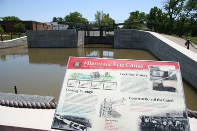
Locking Through
Lock One North is one of 105 locks used to raise and lower boats traveling between Lake Erie and the Ohio River. Large wooden gates were built at each end of the lock to hold water in the lock. A boat, pulled by a team of . . . — — Map (db m23062) HM
Lockkeeper's House
The Lockkeeper's House was the residence of the Lockkeeper and his family. The Lockkeeper was on duty 24 hours a day, seven days per week, and was responsible for operating the lock as needed to move boats through the . . . — — Map (db m22781) HM
The Miami and Erie Canal, connecting the Ohio River with
Lake Erie, was the primary mode of transportation for
cargo in the mid to late 1800s. This allowed towns like
New Bremen to quickly grow and prosper. Local farm
boys, leading the family . . . — — Map (db m167049) HM
The Miami & Erie Canal and New Bremen
Begun in 1833, the Miami Extension linked the Miami Canal in Dayton to the Wabash & Erie Canal at Junction. Engineering difficulties, epidemics and the Panic of 1837 delayed completion of the Extension . . . — — Map (db m20023) HM
Built in 1897, this Queen Anne-design structure features attractive bay windows. Prominently featured in early photos and post cards, the building originally served as Henry Schwaberow's store, an important general store in Monroe Street's . . . — — Map (db m236445) HM
This two-story canal warehouse, rich in German vernacular charm, is especially unique because of the gable ends that face the street and for its full-sized arched windows. Built in 1873 by New Bremen founder Charles Boesel, it was later purchased by . . . — — Map (db m236446) HM
The Honorable Charles Boesel established the first bank in New Bremen at this site in 1866. Located in the community's central business district, the building was erected in the Boesel's front yard, a German custom. — — Map (db m236449) HM
Location for William Bruns' marble cutting business in the 1880's. Bruns, a former mayor, was a dealer in monuments, tombstones, marble mantles, statuary and marble furniture tops. — — Map (db m236453) HM
One of the few New Bremen buildings constructed during the Civil War. Originally, this was the site of Boesel and Kunning's Dry Goods Store. At the turn of the century, Mueller Brothers Clothing Store began operations, selling standard-size and . . . — — Map (db m236450) HM
One of the community's first lumber yards was located originally on this site. Then in 1891, the Hotel Central was constructed and soon became recognized as one of the finest hotels in the area. Salesmen would ride the Western Ohio Interurban, spend . . . — — Map (db m236444) HM
Constructed in 1847, this German Canal Warehouse-style residence was a key building because of its proximity to the Miami-Erie Canal. At one time, it housed the Taylor Photography Studio where generations of New Bremen area residents had their . . . — — Map (db m236443) HM
Once known as the Arcade Department Store, this site served as the center for retail business in New Bremen for more than 60 years. After four local merchants merged their businesses in the early 1900s, it was considered the largest department store . . . — — Map (db m236467) HM
Ice Harvesting from Combs Pond and Rabe's Pond was a major business in the New Bremen community. Ice was cut using a saw and floated to a collection point. It was then packed in layers of sawdust for insulation in a nearby icehouse. The stored ice . . . — — Map (db m236461) HM
How does a community ever payback its founding fathers? The family of business woman, New Bremen native Dianne Komminsk, Chairperson of Board of First National Bank on Washington Street, & founder of the former Micro Foto File Company headquartered . . . — — Map (db m236458) HM
Welcome to the Kuenning-Dicke Natural Area
The Kuenning-Dicke Natural Area, located along the historic Miami and Erie Canal, between Lock One and the former site of Lock Two, offers 74 acres of wildlife protection and a peaceful site for . . . — — Map (db m238553) HM
Robert E. Kuenning Ensign, US Navy
Thomas E. Kuenning Lieutenant, US Army Air Corps
This place marks the location of the Kuenning family farm purchased in 1913 by Emil Kuenning. The property remained in the Kuenning family for four . . . — — Map (db m238564) HM WM
Broadwell Mill On this site a mill was constructed using a mill race for power. Destruction of the mill race by the 1913 flood ended operation. — — Map (db m98845) HM
The wicket gate displayed here is one of three gates manufactured by
St Marys Foundry, Inc.
for the Lock 13 rehabilitation project, completed in 2010. Two gates were installed in the bottom of the north lock doors to maintain hydraulic . . . — — Map (db m185607) HM
First civilian cemetery in the area est. after Treaty of St. Marys in 1817. By Charlie Murray, one of the first Indian traders, who acquired his trading post south of here, after the Treaty of Greenville from James Girty. Murray purchased trade . . . — — Map (db m244296) HM
Established in 1823, the pioneer settlement of St. Marys became a thriving 19th century milling center following completion of the Miami & Erie Canal in 1845. The Reservoir Mill, built by Scott, Linzee & Co. in 1847, led this period of industrial . . . — — Map (db m185830) HM
To the right is the Saint Marys River. This waterway was used by the Indians for generations as a route to hunting grounds in Kentucky. French, and later English traders traversed its course with trade goods in exchange for furs. James Girty, a . . . — — Map (db m30258) HM
To the left is the "Short Level" of the Miami and Erie Canal. The canal extension from Dayton to Toledo was completed in 1837. Linking the Great Lakes to the Ohio River. Travel took only five days to Toledo and six days to Cincinnati. The canal . . . — — Map (db m29673) HM
“Transportation,” Murray seemed to be talking to himself, “transportation you gotta have. No use raisin’ a thousand bushels of wheat if you gotta carry it on your back two bushels at a time all the way to Dayton or Cincinnati to sell it. . . . — — Map (db m185606) HM
The Miami and Erie Canal opened the western Ohio wilderness between Cincinnati and Toledo in the mid-19th century. More than 4000 workers labored to build the canal, earning 30 cents a day, a jigger of whiskey, and room and board. When completed, . . . — — Map (db m235857) HM
Six Mile Creek Aqueduct. Canal aqueducts provide transportation of canal waters over natural waterways, allowing for reliable boat passage. The multi-arch masonry and formed concrete flume of the Six Mile Creek Aqueduct create a unique . . . — — Map (db m234184) HM
1845 - Miami & Erie Canal Opens
1847 The St. Marys flour mill built by Scott, Linzee and Co. was the first industry to use power from the Miami & Erie Canal water in St. Marys. 1860 to 1870 Robert B. Gordon, added three Grist . . . — — Map (db m228161) HM
Grand Lake Saint Marys, originally Mercer County reservoir was worlds largest man made lake when constructed in 1837-1841 Water supply for Miami-erie Canal from here to the Maumee River at Defiance - 17603 acres. in 1856 lake level lowered 5.4 . . . — — Map (db m165762) HM
The Dayton and Michigan Railroad provided the single most important impetus to the growth and development of Wapakoneta. Although Wapakoneta had been platted in 1833, at the time of incorporation (1848), "the town was still without any material . . . — — Map (db m12406) HM
NASA test pilot Neil Armstrong used the F5D Skylancer to create an emergency abort launch/landing procedure for NASA's Dyna-Soar program in the early 1960s. NASA used the F5D in this program because it had similar aerodynamics to the Dyna-Soar . . . — — Map (db m237755) HM
History of the Learjet Corporation
William Lear, born in Hannibal, MO, in 1902, was inspired to build a small private jet by considering a 1950s era prototype Swiss jet fighter. He founded the Learjet Corporation in Wichita, KS in 1963. . . . — — Map (db m237758) HM
began his professional life as a tinsmith, but, by 1880 had established a "general loan, insurance, and collections business," later considered a private bank.
The building is Wapakoneta's only example of the Art Nouveau Style — — Map (db m221607) HM
Learjet 28-001, The Record Setter
The 28 model Longhorn, serial number 001, first flew in 1977. It received FAA certification on July 29, 1979. Neil Armstrong was serving on the Board of Directors of Gates Learjet in 1979 when he was asked . . . — — Map (db m237760) HM
The Nagel Block (1908) was constructed to house the Philip Nagel Furniture and Undertaking Co. For a number of years the third floor was also home to a dance hall called Johnny Nagel's Loft. — — Map (db m237741) HM
Side A:
The Shannon Stock Company, also known as Shannon's Famous Players, was a traveling theatre company based in Wapakoneta from 1913 until the Great Depression. Founded by Harry Shannon, the group included his wife Adelaide, their . . . — — Map (db m29924) HM
Governor Wilson Shannon (1802–1877),
Ohio, first native-born governor, Wilson Shannon was born in February 1802 in the Mt. Olivet area near Barnesville. After attending Ohio University and studying law in Kentucky, he returned to Belmont . . . — — Map (db m21055) HM
Joseph Watt and son James H. started a small foundry in 1862 making plow points, window sash weights, and heating stoves. Later, brothers Stewart, Ross, and John W. joined and the name became J.H. Watt and Brothers. Securing a patent for a . . . — — Map (db m26750) HM
With ready access to raw materials, fuel, skilled labor, and transportation, the Ohio Valley became the center of the American glass industry during the late 1800s. Among dozens of local manufacturers, the Imperial Glass Company, founded in 1901 by . . . — — Map (db m28439) HM
Construction of this Great Stone Viaduct began in 1870 at Union Street as an Ohio approach to the railroad bridge spanning the Ohio River. It was completed to Rose Hill in April 1871, and the entire bridge span connecting Ohio to West Virginia, of . . . — — Map (db m28436) HM
Hanna Coal Company's #10 Mine
March 16, 1940
An explosion ripped through the Willow Grove Mine resulting in the death of 72 Ohio Valley men — — Map (db m78503) HM
The last barn painter for the Bloch Brothers Tobacco Company of Wheeling, West Virginia, Harley Warrick painted thousands of barns with the familiar Mail Pouch Tobacco logo over his 48-year career. Mail Pouch transcended advertising to become a . . . — — Map (db m205139) HM
The bridge was built in 1828 and is 345 feet in length and rises at a 6.3% incline from the east to the west with a 500 foot climb to the top of the hill. The arches are 25 feet, 35 feet and 45 feet in length and were originally earthen filled. . . . — — Map (db m226612) HM
This Civil War cannon is a Confederate twelve pound Napoleon. Also known as a twelve pounder, twelve refers to the weight of the ammunition used by the cannon. Twelve pound smoothbore cannons were frequently used by Confederate and Union armies. . . . — — Map (db m196286) HM
First surveyed in 1849, Powhatan Point was laid out by Franklin Knox. The "point" is the confluence of Captina Creek and the Ohio River. The small but thriving river and farming community served York Township and the rich Captina Valley as a . . . — — Map (db m78499) HM
Side 1
The Coal Industry at Powhatan Point
The Pittsburgh No. 8 coal seam, located 100 feet below river level at Powhatan Point, extends across much of eastern Ohio, western Pennsylvania, and northern West Virginia. The Cleveland and . . . — — Map (db m78501) HM
In recognition of
the patriotism of
the people of
Brown County
who oversubscribed their
war savings quota in 1918
this tablet is
gratefully erected by the
Ohio War Savings Committee — — Map (db m214453) HM WM
Parker and Hood Foundry was owned by John P. Parker and William Hood. They manufactured many farm and household items. They produced 3 sizes of sugar mills. The sugar mills crushed sugar cane or sorghum. The juice extracted could be made into . . . — — Map (db m135471) HM
• Born into slavery 1827
• First sold at age 8
• Forced to march from Norfolk Virginia to Mobile Alabama
• Bought by a doctor
• The doctor’s sons taught him to read and write
• Learned the trade of iron moulding
• Bought his freedom at . . . — — Map (db m135475) HM
“I knew him (John Parker) as a boy, as the man who was afraid to walk on the sidewalk. Winter and summer, rain or shine, he invariably walked in the middle of the street. He did so because Ripley was an old town with many narrow alleys, out of . . . — — Map (db m135452) HM
Ripley was incorporated as the village of Staunton in 1812. Its name
was changed in 1816 to honor General Eleazer Wheelock Ripley, a hero
of the War of 1812. In the years before railroads. Ripley was
principal Ohio River shipping center. Also . . . — — Map (db m135431) HM
A part of the Virginia Military District, Ripley was founded in 1812 by Colonel James Poage, a veteran of the Revolutionary War. Originally named Staunton, after Poage’s home town in Virginia, the village comprised 1,000 acres along the Ohio river. . . . — — Map (db m135427) HM
On this site stood a square two-story brick farmhouse occupied by
Wiiliam Bebb and built in 1835.
After he was elected nineteenth Governor of Ohio, William Bebb
sold his house in 1848 to William Beckett, founder of Beckett Paper
Company, who . . . — — Map (db m116670) HM
Bunker Hill The Millville, Reilly and Milton Turnpike brought prosperity to the
village now renamed Bunker Hill. School House No. 10 stood nearby
from 1849-1857. By 1860 clothing manufacturing was the major
business here. A Post Office was . . . — — Map (db m107801) HM
The Champion Coated Paper Company began production here April 15, 1894, with nine employees under the direction of Peter G. Thomson (1851-1931), a Cincinnati businessman, who had incorporated the firm in November 1893. Thomson, previously a . . . — — Map (db m28547) HM
110 yards from the back of this marker on the present southeast corner of 4th and Butler Streets stood the Cosmopolitan Arms Company, founded by Edward Gwyn and Abner C. Campbell, where carbines for the Union Army were manufactured during the Civil . . . — — Map (db m122283) HM
Mills were essential in the settlers' struggle to convert their land from a debt to an asset. Financial survival depended on access to grist mills, saw mills and carding mills - the trading complexes and community centers on the Ohio frontier. . . . — — Map (db m73595) HM
Fredrick Gottleib Mueller (1873-1947) was commissioned to design this Art Deco structure, the first erected as a Hamilton municipal building, in cooperation with other Hamilton architects, George Barkman and R. E. Smith. This building was renamed . . . — — Map (db m199729) HM
The privately developed Hamilton Hydraulic opened Jan. 27, 1845, providing cheap, reliable water power and starting Hamilton's era of industrial growth and diversification. Water was diverted into the hydraulic canal system from the Great Miami . . . — — Map (db m73598) HM
Side A:
James Elrick, a local carpenter, built the Lane-Hooven House in 1863 for Clark Lane (1823-1907), a Hamilton industrialist and philanthropist. Lane, who first came to the area at age twenty-one as a blacksmith, resided in the house for . . . — — Map (db m28775) HM
Rossville was settled in April 1801 shortly after the U.S. Government initiated land sales west of the Great Miami River. Its original proprietors--John Sutherland, Henry Brown, Jacob Burnet, James Smith and William Ruffin--named the town in honor . . . — — Map (db m28790) HM
Canal boats were designed to haul freight up to 80 tons. Pulled usually by mules, they traveled at approximately three miles per hour.
[Photos] Left, freighters on the Miami & Erie Canal just south of Third Street (now Central Avenue) in 1910. . . . — — Map (db m30422) HM
Canal locks were built to raise and lower boats as the elevation of the land changed. There were 106 locks on the Miami & Erie Canal to overcome a difference in elevation of 512 feet.
The Excello Lock, left, was the first lock completed on the . . . — — Map (db m30423) HM
Canals were built in Ohio to provide a better way to transport goods to the eastern markets. Two major canals were built connecting the Ohio River to Lake Erie - the Ohio Erie & [sic Ohio & Erie] Canal running from Portsmouth to Cleveland and the . . . — — Map (db m30375) HM
Port Middletown, located at Third St. (Central Ave.), was the main port along the Miami & Erie Canal. A scale was located there and tolls were collected.
[Photos] Left, a fire in 1881 at the Ben Smith Livery at Port Middletown has just been . . . — — Map (db m30418) HM
In emulation of those who, July 21, 1825,
here began the building of the
Miami & Erie Canal,
this Ohio property was rededicated
November 2, 1929, to its original purpose -
transportation, with the confident hope
that a super-highway . . . — — Map (db m29665) HM
Ohio's canal system was the most effective between 1827 and 1850, before the introduction of the railroads. In Middletown, the canal was still used well into the 20th century but in 1913 a devastating flood destroyed much of the canal. In 1929 . . . — — Map (db m30430) HM
The lift bridge built in 1899 across the Miami & Erie Canal at Third Street (now Central Ave.), was the third bridge at this site since the canal began in 1825. An electric motor was used to raise the west portion of the floor of the bridge up the . . . — — Map (db m30431) HM
In c1795 Bambo Harris a freed black slave built and operated the first Water Driven gristmill in the area on Elk Creek. For fifty years his Millstones ground wheat and corn. A member of the Prairie Baptist Church, he was highly respected in the . . . — — Map (db m28779) HM
The village of Miltonville, located along the banks of Elk Creek, was platted in 1816 by George Bennett, Theophilus Eaglesfield, and Richard V. V. Crane. The creek served two grist mills, one built around 1804 and operated by a free black, Bambo . . . — — Map (db m28776) HM
Front One of the few remaining covered bridges in southwestern Ohio and the only one in Butler County on its original site, this bridge was built in 1868-1869 to give access to a saw and grist mill owned by James B. Pugh on Four Mile . . . — — Map (db m86977) HM
Side A: The Doty Settlement
As Oxford Township was developing in the mid-1800s, a cluster of farmsteads near its northern border was designated the "Doty Settlement." As was the custom, the community took its name from a prominent family in . . . — — Map (db m24015) HM
The life of Verlin L. Pulley was
long intertwined with Miami University.
A member of the class of 1925
A trustee from 1959 to 1965
A resident orf Oxford since graduation
and mayor of Oxford from 1936-1940
The founder of Capitol Varsity . . . — — Map (db m25006) HM
Side A: The Village of Trenton
Platted 1816. Incorporated as Village 1895. Became a city 1971
Trenton's founder, Michael Pearce, came to the area in 1801. The original village of 33 lots was named Bloomfield. When the post office was . . . — — Map (db m28792) HM
The Algonquin Mill
was named for an Indian camp site near the settlement which is now Petersburg. This structure, built about 1826, replaced an earlier mill. Originally operated by water power from Little McQuire Creek, it drove two sets of burrs. . . . — — Map (db m159707) HM
Platted by Samuel Oswalt and John Wagoner in 1831. Worley’s Hotel, built in 1820, was the first stage coast stop between Bolivar-Canton and Steubenville. The road followed the first white man’s trail, established by Bezaleel Wells who founded Canton . . . — — Map (db m159693) HM
[Marker Front]:
The Dayton, Springfield, and Urbana Electric Railway (DS&U) was an “Interurban” rail system that ran between the cities of Urbana, Springfield and Dayton. Its beginning can be traced to the franchise given to . . . — — Map (db m13811) HM
Before 1800, there were approximately 7,000 acres of wetland in this valley. By 1980, draining had reduced the wetlands to only 130 acres of hardwood swamp forests, cedar swamp forests and sedge meadows.
By the 1980s, this sedge meadow was . . . — — Map (db m198694) HM
Warren G. Grimes. Raised in an Ohio orphanage, Warren G. Grimes (1898-1975) ran away after finishing the ninth grade and at age 16 went to work for the Ford Motor Company in Detroit. He later became a partner in an electrical business where . . . — — Map (db m13818) HM
The Johnson Manufacturing Company was incorporated in 1902 by brothers James B., J. Will, Isaac T., and Charles F. Johnson, all of Quaker heritage. The company manufactured tin and galvanized iron ware for railroad lines across the United States. . . . — — Map (db m221049) HM
[Marker Front]:
Asa Bushnell, former Governor of Ohio, encouraged by the light grade of the land, decided to establish the Springfield, Troy, and Piqua Railway (ST&P) in July 1904. The interurban traction line utilized sixty-pound rail and . . . — — Map (db m13890) HM
Asa Smith Bushnell, born in Rome, New York, settles in Springfield in 1850. After serving in the Civil War, Bushnell begins to work for a company partially owned by Benjamin Warder, eventually becoming a partner, now the Warder, Bushnell, and . . . — — Map (db m81955) HM
The Old City Building and Market, also known as the Municipal Building or Marketplace, was designed by local architect Charles A. Cregar. It was completed in 1890 at a cost of $250,000. Vendors, who sold meats, fish, provisions, vegetables, and . . . — — Map (db m13309) HM
Toulmin, as patent attorney for the Wright Brothers, plays a key role in one of the greatest sagas in American history. After failing to obtain the necessary patents on their own, the Wright's hire Toulmin to defend their inventions. His legal work . . . — — Map (db m13907) HM
Springfield's "first inventor", born in Virginia, brings a genius previously unparalleled in the history of our community. His passion for the use of the abundant water supply in the area accelerates Springfield into the early beginnings of the . . . — — Map (db m81932) HM
John Burton Mitchell (better known as Tink) was born on April 20, 1935, in Springfield, Ohio. He moved to this property, located at 1403 Linden Avenue, in 1968 with his wife Shirley (Williams) Mitchell, and their two daughters. Tink lived here . . . — — Map (db m213801) HM
Affectionately called by some, “The Father of Ferncliff Cemetery”, John Ludlow is a member of an early pioneer family in Clark County, eventually becoming a well-known pharmacist. In 1851, he is elected as a director of the Springfield . . . — — Map (db m81896) HM
Raised on farms in Greene Township, O.S. Kelly became one of the most respected local businessmen and benefactors of his age. A skilled carpenter, he made his fortune building housing for miners during the California gold rush. Upon returning to . . . — — Map (db m13312) HM
O. S. Kelly grows up on a farm in Greene Township of Clark County later turning his efforts into carpentry trade. In 1852, Kelly temporarily leaves his family to seek his fortune in the California gold rush building dwellings for the miners, . . . — — Map (db m82050) HM
Known nationwide as the “Reaper King”, William Whiteley places Springfield on the map with his innovative improvements of Cyrus McCormack’s reaper. A born machinist with an inventive mind, Whiteley is constantly seeking ways to improve . . . — — Map (db m82049) HM
The Ridgewood neighborhood, platted in 1914, was one of the first
fully planned and restricted suburbs in the United States. Its
innovative developer, Springfield native Harry S. Kissell, was among
a small group of nationally acclaimed real . . . — — Map (db m117567) HM
The Ohio Society DAR on July 4, 2003, placed this
Rededication Marker to Commemorate the
75th Anniversary of the Madonna of the Trail Statue.
The Statue has been restored through the efforts of:
• Ohio Society Daughters of the . . . — — Map (db m108425) HM
For nearly 80 years Clark County was home to a flourishing nursery and florist industry. In fact, Springfield and Clark County grew and shipped more roses than any other city in the country. Rose growing and shipping became a multi-million dollar . . . — — Map (db m215403) HM
1349 entries matched your criteria. Entries 101 through 200 are listed above. ⊲ Previous 100 — Next 100 ⊳