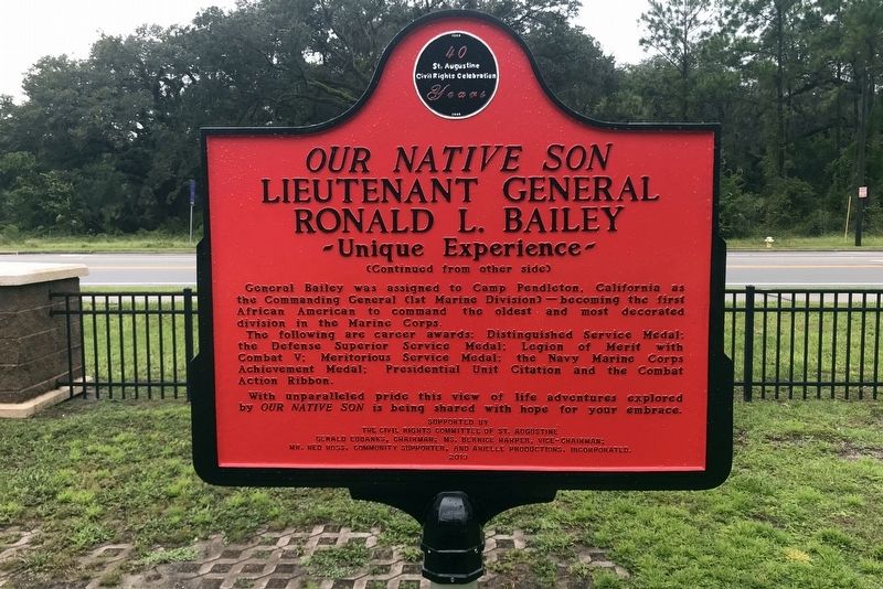
On North Holmes Boulevard at West King Street (County Road 214), on the right when traveling north on North Holmes Boulevard.
General Bailey was born and once played in/shared the culture of the neighborhood of West Augustine, directed by his parents and the elementary school personnel. Born during the civil rights era which was spearheaded locally by Florida Memorial . . . — — Map (db m156555) HM
Fullerwood School was built in 1927 and is the only example in St. Augustine of the work of noted architect A. Ten Eyck Brown (1878-1940), famed for his courthouses, banks, and city halls in New Orleans, Miami and Atlanta. His name is on the . . . — — Map (db m40725) HM
This was the home of Mrs. Georgie Mae Reed (1926-1995), who took part in one of the most famous events in the civil rights movement that changed America and inspired the world.
On March 31, 1964, Mrs. Reed was one of five St. Augustine women who . . . — — Map (db m65420) HM
On West King Street, on the right when traveling west.
Leo C. Chase, Sr., who had previously managed the Huff Funeral Home in Lincolnville, opened one of the oldest businesses in St. Augustine, this funeral home in 1955. His son, Arnett Chase, took over after his father's death in 1977. Another son, . . . — — Map (db m40723) HM
On King Street (County Road 214) 0.1 miles west of A1A Scenic and Historic Costal Byway.
The Ponce de Leon Shopping Center opened in 1955 as the first downtown shopping center in St. Augustine. It was designed by Morris Lapidus (1902-2001), Florida's most famous mid-twentieth century architect, and is the only example of his work in the . . . — — Map (db m7696) HM
On Chapin Street, on the right when traveling north.
57 Chapin Street was once the home of Willie Galimore (1935-1964), the most famous athlete to come from St. Augustine. A three-time Pittsburgh Courier All-American football player at Florida A & M University under the legendary coach Jake Gaither, . . . — — Map (db m7732) HM
This was the home of Rev. Roscoe Halyard and his wife Flora, both active participants in the civil rights movement of the 1960s. Rev. Halyard, who was associated with Zion Baptist Church and worked as a carpenter, made trips to both Tallahassee and . . . — — Map (db m21208) HM
This house was built in 2008 by Habitat for Humanity for one of the Ancient City's civil rights heroes, Audrey Nell Edwards. Along with JoeAnn Anderson Ulmer, Samuel White, and Willie Carl Singleton, she was one of the "St. Augustine Four." As . . . — — Map (db m40724) HM
The house at 8 Scott Street was built in the 1950s as part of Rollins Subdivision, a new residential area where many prominent black St. Augustinians made their homes. In the early 1960s it was the residence of Dr. Robert B. Hayling and family. A . . . — — Map (db m7628) HM
Zion Baptist Church, with its distinctive double towers, was built in 1921 to house a congregation originally organized in 1886. It is the last house of worship passed by many funerals on their way to several nearby cemeteries, including the one . . . — — Map (db m7803) HM
On Marine Street, 0.1 miles south of St. Francis Street, on the right when traveling south.
Civil War Dead
An estimated 700,000 Union and Confederate soldiers died in the Civil War between April 1861 and April 1865. As the death toll rose, the U.S. government struggled with the urgent but unplanned need to bury fallen Union . . . — — Map (db m127668) HM
Near Marine Street, 0.1 miles south of St. Francis Street, on the right when traveling south.
Four score and seven years ago our fathers brought forth on this continent, a new nation, conceived in Liberty, and dedicated to the proposition that all men are created equal.
Now we are engaged in a great civil war, testing whether that . . . — — Map (db m144126) HM WM
On Fort Mose Trail, 0.2 miles east of North Ponce De Leon Boulevard (U.S. 1), on the right when traveling north.
Fort Mose (Moh-Say) was a multicultural community of people originally from West and Central Africa, along with some Native Americans.
Some of the residents of Mose, like Francisco Menéndez, fought in the 1715 Yamasee War against the . . . — — Map (db m126973) HM
Near Avenida Menendez at King Street (Business U.S. 1), on the right when traveling north.
The body of water in front of you is the Atlantic Intracoastal Waterway (AICW). The Intracoastal Waterway is also known as the Marine I-95. The AICW is a marked continuous navigation channel that begins in Virginia and ends in Key West. The AICW . . . — — Map (db m143619) HM
On Fort Mose Trail, 0.2 miles east of North Ponce De Leon Boulevard (U.S. 1), on the right when traveling north.
In 1740, the English attacked St. Augustine, but departed after a bloody battle at Fort Mose.
Georgia Governor James Oglethorpe invaded Florida with a sizable force, including Lower Creeks and Uchise Indian allies. Fort Mose inhabitants . . . — — Map (db m126968) HM
On Fort Mose Trail, 0.2 miles east of North Ponce De Leon Boulevard (U.S. 1), on the right when traveling north.
Once in English Carolina, the enslaved Africans were forced into labor and had no legal standing and few rights.
Africans labored on indigo plantations, and as lumbermen and cattlemen. They produced materials for shipbuilding and cleared . . . — — Map (db m126965) HM
On Bridge Street east of Cordova Street, on the left when traveling east.
These two buildings, at 42 and 46 Bridge Street, are among the few Territorial Period buildings left in the city which represent the time period between 1821 and 1845. Antonio Canova purchased the property and built these structures for his sons. . . . — — Map (db m111551) HM
On St. George Street at Bridge Street, on the right when traveling south on St. George Street.
Building patterns were influenced by the royal decree of 1573 to situate buildings and walls along the street edge for defensive purposes. The Prince Murat house is one of the remaining Spanish Colonial buildings and is significant for its . . . — — Map (db m108318) HM
On Saint George Street south of King Street (Business U.S. 1), on the right when traveling south.
Pedro Horruytiner y Pueyo was the first documented owner of this house, a member of a prominent Spanish family. Don Pedro Benedit Horruytiner and Don Luis de Horruytiner were governors of Florida during the First Spanish Period (1565-1763). It . . . — — Map (db m111752) HM
On Aviles Street just north of Bravo Lane, on the left when traveling south.
English Foundations of a Stone House Wooden boards sit atop and mark the coquina stone foundations of a building that formed the street corner for more than a century (circa 1740 - 1870). Constructed by Spanish residents, the . . . — — Map (db m188469) HM
On Aviles Street at Bravo Lane, on the left when traveling south on Aviles Street. Reported permanently removed.
The 1990 excavation of this coquina block well revealed furniture fragments from the 1600s, a rarity among St. Augustine's artifacts. Most likely, the well was built in the early 1600s and filled quickly about 1670 with household items from a . . . — — Map (db m93269) HM
On Cordova Street at King Street (Business U.S. 1), on the right when traveling north on Cordova Street. Reported missing.
Designed and built by Franklin W. Smith, the Casa Monica Hotel opened in January 1888. The medieval Spanish style structure was one of the earliest multi-storied buildings in the United States constructed of poured concrete. In April 1888, Henry M. . . . — — Map (db m129656) HM
Near Marine Street north of San Salvador Street, on the left when traveling north.
These three pyramids cover vaults containing the individually unidentified remains of 1468 soldiers of the Florida Indian Wars
1835-1842
The Florida Indian Wars began with the murder of an Indian agent at Fort King on December 25, 1835. . . . — — Map (db m77411) HM WM
On Aviles Street, on the right when traveling south.
Following the typical model of Spanish Colonial site planning, this structure is situated on the street edge and features coquina stone construction with a protective stucco finish. The exposed fireplace is a reminder of another structure that was . . . — — Map (db m108056) HM
On Fort Mose Trail east of N. Ponce de Leon Blvd. (U.S. 1).
Great Seal of the State of Florida:"In God We Trust"
On the shore of Robinson Creek, ¼ mile east of this marker, was the site of a Spanish mission for Indians left homeless during Queen Anne's War. Since 1688, Negro slaves . . . — — Map (db m126969) HM WM
On Fort Mose Trail, 0.2 miles east of North Ponce De Leon Boulevard (U.S. 1), on the right when traveling north.
In 1693, Spain’s King Charles II proclaimed that any English slave who reached Spanish Florida would be granted freedom upon converting to Catholicism.
By sea and land, Africans fled to St. Augustine on a dangerous journey with a strong . . . — — Map (db m126966) HM
On Fort Mose Trail, 0.2 miles east of North Ponce De Leon Boulevard (U.S. 1), on the right when traveling north.
Spain ceded Florida to England in 1763, and Mose residents departed with other colonists for Cuba.
During Fort Mose's final years, life on the frontier grew more difficult. Constant attacks by English and Indian raiding parties drove . . . — — Map (db m126971) HM
On North Rodriguez Street south of Pearl Street, on the left when traveling north.
Established in 1884 outside the city limits when St. Augustine closed its small urban graveyards due to overcrowding. Evergreen became the region's largest Protestant cemetery of the late 1800s and early 1900s. The design was strongly influenced by . . . — — Map (db m73842) HM
A tabby interior wall provides evidence that a portion of this building remains from the First Spanish Period before coquina stone construction took its place. Tabby was a form of construction that produced a cement slurry with an aggregate of . . . — — Map (db m107452) HM
On St Francis Street west of Charlotte Street, on the left when traveling west.
This house was already extant in 1763, when Spain ceded Florida to Great Britain. It was then a one-story, two-room, shingle-roofed coquina stone structure owned by Pedro Fernandez. A British owner added the loggia.
In 1784, when the Spanish . . . — — Map (db m77290) HM
On Marine Street at St. Francis Street, on the left when traveling west on Marine Street.
Each year, the Florida National Guard celebrates the anniversary of the First Muster of Florida’s militia. Governor Pedro Menendez organized the first group
of Citizen Soldiers on September 16, 1565. — — Map (db m162988) WM
On King Street at Charlotte Street, on the right when traveling east on King Street.
Colonized by Spaniards, 1559 • Site of first settlement in U.S., 1565 • Acquired by U.S. from Spain, 1819 • Admitted as 27th state, 1845 • Now nation's fastest growing state • 1963 population 5,639,900 • State song ~ "Old Folks at Home" • State Bird . . . — — Map (db m5999) HM
On North Holmes Boulevard at West King Street (County Road 214), on the right when traveling north on North Holmes Boulevard.
Founded 1879—Live Oak, Florida
Jacksonville, Florida—1892-1918
St. Augustine, Florida—1918-1968
Miami Gardens, Florida—1968-Present
Students of Florida Normal and Industrial Memorial College, in the early 1960s . . . — — Map (db m67672) HM
Near Outlet Mall Boulevard, 0.2 miles north of Outlet Center Drive when traveling north.
Ford Motor Company's first purpose-built plant was erected in 1904 on Piquette Street in Detroit, Michigan. Many early Ford models were built here but most notably the design and build of the Model T in 1908 and 1909. The first 12,000 Model T's were . . . — — Map (db m215910) HM
This building, designed by architect F. A. Hollingsworth, opened in 1953 as the St. Johns County Jail, replacing an earlier jail building on San Marco Avenue that subsequently became a tourist attraction. A decade later, this building played a . . . — — Map (db m40728) HM
Near Fort Mose Trail, 0.2 miles east of North Ponce De Leon Boulevard (U.S. 1) when traveling east.
All that remains of Fort Mose is underground - on the island before you, and in the surrounding salt marsh.
Working together, archaeologists and historians have pieced together the story of Fort Mose using historic documents, maps, aerial . . . — — Map (db m126972) HM
On Fort Mose Trail, 0.2 miles east of North Ponce De Leon Boulevard (U.S. 1), on the right when traveling north.
In 1738, after more than 100 runaways arrived from Carolina, the Spanish governor established Fort Mose.
As Africans continued to flee Carolina, frontier skirmishes between the English, Spanish, and their Native American allies threatened . . . — — Map (db m126967) HM
On Fort Mose Trail, 0.2 miles east of North Ponce De Leon Boulevard (U.S. 1), on the right when traveling north.
Twelve years after the Bloody Mose battle, Mose residents returned to the frontier and constructed a second fort and community.
Mose's fort, houses, and surrounding fields were destroyed during the siege of St. Augustine. From 1740-1752, . . . — — Map (db m126970) HM
On Fort Mose Trail, 0.2 miles east of San Marco Avenue (U.S. 1), on the right when traveling east.
Fort Mose Site has been designated a National Historic Landmark
This site possesses national significance in commemorating the history of the United State of America — — Map (db m220154) HM
On St. Francis Street just west of Marine Street, on the right when traveling west.
Spaniards first settled Florida permanently at the site of St. Augustine in 1565. They raised their vivid red and white flag to establish possession of the land for their king.
The Spanish flag flew over the little garrison town for 235 years, . . . — — Map (db m112507) HM
On San Marco Avenue (U.S. Bus 1) at Macaris Street, on the right when traveling north on San Marco Avenue.
Fullerwood Park reflects multiple periods of housing growth for St. Augustine's middle class. The district exhibits design characteristics from the periods of World War I, the 1920s Florida land boom, and post-World War II. The district, featuring . . . — — Map (db m110519) HM
On Saint George Street at Saint Francis Street, on the left when traveling south on Saint George Street.
The house was built as a residence for Gaspar Garcia and Spanish characteristics are still evident including how the building relates to the street edge and the coquina stone building material protected under a stucco finish. Later, a third floor . . . — — Map (db m108143) HM
On St Francis Street east of Charlotte Street, on the right when traveling west.
For more than three centuries this site has been occupied by St. Augustinians. Beginning about 1650, a succession of thatched wooden structures were their homes. This coquina stone house was built soon after the English burned St. Augustine in 1702, . . . — — Map (db m77288) HM
On St. Francis Street just west of Marine Street, on the right when traveling west.
This building is significant because of the site's early Spanish Colonial history and architectural features that represent both Spanish periods and the British period. A significant restoration based in archaeological, documentary and physical . . . — — Map (db m112506) HM
On Vilano Road east of Poplar Avenue, on the right when traveling east.
This original motor court sign is an icon of the Vilano Beach tourism boom of the 1940s and 50s. Haley’s Court was one of several art-moderne styled, family oriented motels lining Vilano Road at mid-century.
This sign was donated to St. . . . — — Map (db m125692) HM
On Marine Street, 0.1 miles south of St. Francis Street, on the right when traveling north.
This is the only known building with its origin in the British Period that exists in St. Augustine. Until Marine Street was developed, the Bakery was contiguous with the St. Francis Barracks property. The British converted and expanded the Spanish . . . — — Map (db m112509) HM
On Saint Francis Street west of Marine Street, on the left when traveling west.
In the 1600s, Spanish Florida's Royal Road connected St. Augustine with the missions of North Florida.
From the time St. Augustine was established in 1565, Spanish military and religious authorities began extending their reach beyond the . . . — — Map (db m153924) HM
On Saint Francis Street, on the left when traveling west.
This building is significant for its Spanish and British Colonial architectural influences and in 1954 became one of the first examples of a private residence to undergo a documented restoration. Characteristics of the "St. Augustine Plan" of . . . — — Map (db m108073) HM
On Marine Street north of San Salvador Street (Road 0), on the left when traveling north.
On December 28, 1835, during the Second Seminole War, a column of 108 U.S. Army soldiers dispatched from Fort Brooke (Tampa) to relieve the detachment at Fort King (Ocala) was surprised by a strong force of Seminole Indians near Bushnell in Sumter . . . — — Map (db m77413) HM
On Marine Street south of Bridge Street, on the left when traveling south.
Coquina stone was quarried on Anastasia Island for use as a construction material, and after the Castillo was completed the material became widely used for private homes as a superior alternative to wood frame construction. Francisco Marin, a . . . — — Map (db m111550) HM
On Fort Mose Trail, 0.2 miles east of North Ponce De Leon Boulevard (U.S. 1), on the right when traveling north.
During the 18th century, thousands of enslaved Africans faced starvation, torture, and even death on their journey to the Americas, a voyage known as the middle passage.
What was the Middle Passage?
The Middle Leg of a 3-part Voyage:
. . . — — Map (db m126964) HM
On Tremerton Street at South Street, on the right when traveling north on Tremerton Street.
From the late 1720s to the early 1750s the green space just beyond this wall was the site of the church and cemetery for the mission community of La Punta (FL Site #8SJ94). This mission was home to refugee Yamassee and Apalachee Indians who had fled . . . — — Map (db m92980) HM
On Nelmar Avenue at Magnolia Avenue when traveling east on Nelmar Avenue.
The Nelmar Terrace area has been the site of portions of a Timucuan Indian village, a plantation under British Governor James Grant in the 1770s, and parcels of Spanish land grants after 1784. From 1844-1869 the area was the southern part of the . . . — — Map (db m100892) HM
Near Marine Street north of San Salvador Street, on the left when traveling north.
This garden is a living tribute to all
of America's veterans and their
families. In silence and respect, this is
a place to remember why millions of
Americans have fought and died for
our liberty and our freedom.
Here we renew our . . . — — Map (db m220157) WM
On North Mc Laughlin Street at John Street, on the right when traveling north on North Mc Laughlin Street.
This site, and main-building, has served as administration, classroom
instruction, and community center—circa 1901 to 1959 – and as a
BEACON-OF- HOPE for the educational and cultural aspirations of a
community with great expectations – . . . — — Map (db m134538) HM
Near Saint George Street south of Cadiz Street, on the right when traveling south.
On this site, Spanish colonists built the chapel of Nuestra Señora de la Soledad shortly after 1572.
A hospital was attached in 1597, thus becoming the first hospital in the continental United States.
In 1687 the chapel was . . . — — Map (db m108377) HM
On Aviles Street at King Street (Business U.S. 1), on the left when traveling south on Aviles Street.
On this site, the City Archaeology Program uncovered remains of the west wall of the late 16th century church, Los Remedios, which served as the parish church of St. Augustine from 1572 until 1702.
Burned by Francis Drake in 1586 and . . . — — Map (db m93381) HM
On Marine Street, 0.1 miles south of St. Francis Street/Avenida Menendez, on the right when traveling south. Reported permanently removed.
The houses on this post are known as the Officers' Quarters. St. Francis Barracks commanding officer from 1875 to 1883, Brevet Brig. Gen. Frederick Dent, lobbied for this construction. Dent allegedly asked First Lady Julia Dent Grant, his sister, . . . — — Map (db m131196) HM
On Marine Street at St. Francis Street, on the left when traveling west on Marine Street.
Civil War structures on parade field included stables, storehouses, wood and gun sheds.
Hospital constructed for U.S. Troops moved across Marine Street circa 1913. — — Map (db m163288) HM WM
On Pearl Street, 0.1 miles east of North McLaughlin Street, on the left when traveling west.
Pinehurst is believed to be the earliest segregated African American cemetery in Florida with graves dating back to the 1840s. Similar to San Sebastian, many veterans from the Civil War, WWII, and the Korean War laid to rest here peacefully. — — Map (db m216292) HM
Friends of Libraries U.S.A.
Literary Landmarks Register
Randolph Caldecott 1846-1886
The Caldecott Medal, commissioned in 1938, was named in honor of English illustrator, artist, and sculptor Randolph Caldecott. It is . . . — — Map (db m152195) HM
On West King Street west of South Whitney Stret, on the left when traveling west.
This Masonic Lodge, built in 1947 with George Morgan as Worshipful Master, was originally organized in 1925 and represents a merger (in 1984) of Prince Hall Lodges—S.D.W. Smith No. 481, Ancient City No. 26, and Mt. Horeb No. 20. This facility is . . . — — Map (db m76918) HM
On South Castillo Drive (State Highway A1A) at Orange Street, on the right when traveling south on South Castillo Drive.
English:
Safe Haven
Farmers bring crops and food from their fields surrounding the town. Open for trade during the day, but locked up at night, this city gate is the entrance to early 1800s civilization. Here in St. . . . — — Map (db m128083) HM
Near San Marco Avenue (Business U.S. 1) at Old Mission Avenue (Business U.S. 1), on the right when traveling north.
Beginning in the early 1500s and continuing for more than three centuries, about 12 million African were transported across the Atlantic Ocean into slavery, in what has come to be known as the Middle Passage—the largest forced migration in . . . — — Map (db m80700) HM
On St. Francis Street at Charlotte Street, on the left when traveling east on St. Francis Street.
The coquina walls of this authentic example of an early Spanish colonial home were built soon after the town was burned during the siege of 1702. Changes and additions made by succeeding generations reflect the city’s history. Archaeology . . . — — Map (db m153773) HM
On Pearl Street, 0.1 miles east of North McLaughlin Street, on the left when traveling west.
This cemetery is an early segregated burial site for the African Americans community in Florida with graves dating back to the 1880s. Carved chains on headstones indicate the person was born a slave. Adornments of shells and planted ferns are left . . . — — Map (db m216294) HM
On St. George Street, on the right when traveling south.
This house was built circa 1809 by Francis Xavier Sanchez and his wife, Mary Hill of Charleston, lately of Virginia. That is the probable reason for the English colonial interior rather than the usual Spanish. This house was retouched for posterity . . . — — Map (db m46790) HM
On St George Street south of Hypolita Street, on the left when traveling south.
Historic records indicate that in 1816 a wooden structure occupied this property and by 1829 it was replaced with this prominent two-story coquina stone structure. Concerted efforts to preserve this structure began during the preservation movement . . . — — Map (db m102380) HM
On Orange Street at Cordova Street, on the right when traveling west on Orange Street.
Historians and archaeologists consulted Colonial and Territorial Period documents to locate the site of the Santo Domingo Redoubt, which was also referred to at various times as the Tolomato Redoubt. Archeological excavations of the Santo Domingo . . . — — Map (db m46581) HM
On Orange Street at Cordova Street, on the right when traveling west on Orange Street.
In 1704, following the English siege of 1702, the Spanish built the Cubo Line to protect the town's northern sector. In the 1730s, they rebuilt the line in anticipation of an English attack from Georgia. In 1808, a time of upheaval in the Spanish . . . — — Map (db m46609) HM
On Orange Street at Cordova Street, on the right when traveling west on Orange Street.
The Infantry Regiment of Cuba was formed in 1786-1789 as a result of Spanish military reforms introduced in the second half of the 1700s. The Regiment consisted of three battalions. The First and Second Battalions were assigned to Havana and . . . — — Map (db m46631) HM
On Orange Street at Cordova Street, on the right when traveling west on Orange Street. Reported unreadable.
Following the 1702 English siege of St. Augustine, the Spanish began construction of a system of peripheral fortifications to protect the town based on the principle of defense-in-depth. Between 1704-1821, the Spanish completed the outworks of the . . . — — Map (db m188270) HM
On South Castillo Drive (State Road A1A) (Business U.S. 1) near 1 South Castillo Drive, on the right when traveling north.
Saving the Seawall (English)
Hurricanes, waves, and rain have weakened the fort's historic 1840s seawall. In 2011, the National Park Service created a living seawall using coquina boulders. Silt filling the space between the two . . . — — Map (db m127740) HM
On Artillery Lane west of Aviles Street, on the left when traveling west.
The two-story coquina stone structure was built prior to 1800 to replace a two-story structure that had a rubble masonry first floor and wood frame second floor. Typical of Spanish Colonial site planning, the building is constructed on the street . . . — — Map (db m112493) HM
An Early Warning System The Spanish were well versed in the art of war. They built watchtowers around St. Augustine in order to spot potential danger early enough to muster an effective defense. These two examples of mid-sixteenth . . . — — Map (db m189127) HM
Near South Castillo Drive (State Road A1A), on the right when traveling north.
It enabled the sentry to watch outside the fort to the front and sides, and sheltered him from weather and enemy fire. These turrets were red against the white walls of the fort. You can help save the remaining red plaster by not touching it. — — Map (db m46514) HM
On West King Street east of South Whitney Street, on the right when traveling east.
This spiritual and civic citadel was established in 1929 with Rev. R.H. Whittaker as spiritual leader, and Chairman of the Board of Deacons, D.P. Mims. This church, the gateway to New Augustine, experienced phenomenal growth under the inspired . . . — — Map (db m77284) HM
On Marine Street, 0.1 miles east of Cadiz Street, on the right when traveling east.
This bronze sculpture of a Timucuan child with open arms reflects the innocence of youth and joyful nature of humanity. Installed to honor the sacrifice and labors of the indigenous people, it marks the site were rare Native American artifacts . . . — — Map (db m154004) HM
On St. George Street south of Cadiz Street, on the left when traveling south.
October 15, 1650 - Sisters of St. Joseph are founded in Le Puy-en-Velay, France
September 2, 1866 - First colony of eight Sisters from Le Puy reach Picolata Landing on the St. Johns River on their journey to St. Augustine
January 15, . . . — — Map (db m126652) HM
Near Williams Street east of Magnolia Avenue when traveling east.
Site of the First Fort San Juan de Pinos built by Pedro Menéndez de Avilés A.D. 1565 destroyed 21 years later by Sir Francis Drake 1586 ——————— This tablet authorized by the following committee appointed by the City of St. Augustine, Fla. . . . — — Map (db m221849) HM
Near Avenida Menendez (Florida Route A1A) south of Hypolita Street, on the right when traveling south.
On this site, June 18, 1964, sixteen Jewish clergy
marching in protest for civil rights at the request of
the Reverend Dr. Martin Luther King, Jr.
were arrested in the largest mass arrest
of rabbis in United States history.
St. . . . — — Map (db m153728) HM
Near South Castillo Drive (State Road A1A) (Business U.S. 1) at Cuna Street, on the right when traveling north.
Sizzling Salvo (English)
The furnace fire is blazing hot. A team of soldiers prepares hot shot to fire at wooden warships — heating cannonballs until they glow. During a naval attack, one soldier tends the coal fire and loads the . . . — — Map (db m127739) HM
On Cathedral Plaza at Charlotte Street, on the left when traveling west on Cathedral Plaza.
From 1605 to 1765 there stood on this site a guard house and watch tower Under British rule it became the market and place of public auction ever since called the slave marketThis tablet authorized by the following committee appointed by the city . . . — — Map (db m46818) HM
Near San Marco Avenue (Florida Highway A1A) (Business U.S. 1) south of Dufferin Street, on the right when traveling north.
Fort Mose was established in 1738, when over 100 runaway slaves arrived seeking refuge from their northern plantations. It was the first free Black settlement of self-emancipated slaves in what is now the United States.
Spanish Governor Manuel . . . — — Map (db m134492) HM
On Charlotte Street at Cadiz Street, on the left when traveling north on Charlotte Street.
The coquina stone, for construction of this and other Colonial structures in St. Augustine, was quarried on Anastasia Island and requires a stucco finish to protect the native shellstone from the elements. Several buildings are located on this site . . . — — Map (db m111471) HM
On Riberia Street at Sabastian Harbor Drive, on the right when traveling south on Riberia Street.
This building is a significant example of St. Augustine's industrial heritage in cigar manufacturing at the beginning of the 20th century. Overall, the building represents a masonry vernacular style because of the use of local materials like the . . . — — Map (db m111253) HM
On Ribera Street at Sebastian Harbor Drive, on the right when traveling south on Ribera Street.
The Solla-Carcaba Cigar Factory, completed in 1909, is the last remnant in St. Augustine of the cigar industry, whose local origins date to the 1830s. Political unrest drove many Cuban cigar makers to Florida after 1868. Their numbers in St. . . . — — Map (db m77391) HM
Near Aviles Street at Artillery Lane, on the right when traveling south.
These statues tell the story of two residents of the Segui Kirby Smith House. Edmund Kirby Smith (right) was born in this house in 1826 and Alexander H. Darnes (left) a slave of the Smith's was born ca. 1846.
E. K. Smith graduated from West . . . — — Map (db m143639) HM
A Natural Plant for Defending St. Augustine A member of the yucca family, this hardy plant grows all across North and Central America from coast to coast. With over 40 species across the continent, this evergreen is easily recognized . . . — — Map (db m189126) HM
380 entries matched your criteria. The first 100 are listed above. Next 100 ⊳