Near St. George Street, 0.1 miles south of Fort Alley, on the left when traveling south.
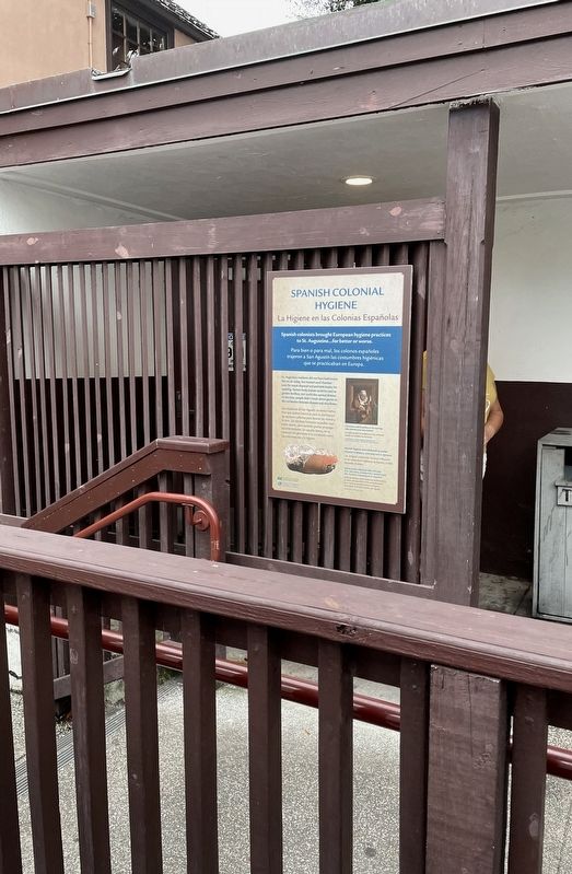
Spanish colonists brought European hygiene practices to St. Augustine...for better or worse.
Para bien o para mal, los colonos españoles trajeron San Augustín las costumebres higiénicas que se practicaban en Europa.
St. Augustine residents . . . — — Map (db m188340) HM
On Cordova Street at Cll Street, on the right when traveling north on Cordova Street.
A first Spanish period two-story coquina, shingle roofed structure, 33' x 19', erected on the east side of this lot became the barracks for the Spanish dragoons in 1792. Each story had two rooms. One upper room contained a rack for 20 muskets and 40 . . . — — Map (db m47058) HM
On King Street at St. George Street, on the left when traveling east on King Street. Reported missing.
Spanish Public Well
Constructed prior to 1763
Filled and partially destroyed
during British Occupation
1763 – 1784
Restored 1975 as a Bicentennial project of:
City Of St. Augustine
Historic St. Augustine Preservation . . . — — Map (db m220568) HM
Near South Castillo Drive (State Road A1A) (Business U.S. 1) at Cuna Street, on the right when traveling north.
Spanish Stronghold (English)
Castillo de San Marcos symbolizes Spain's vast New World empire. Built between 1672 and 1695, the coquina fort replaced a series of wooden forts that had protected St. Augustine for more than 100 years. . . . — — Map (db m128186) HM
On San Marco Avenue (Business U.S. 1) at Missouri Avenue, on the left when traveling south on San Marco Avenue.
You think your job is tough?
Try being a manure spreader in the 1800s.
Imagine the relief for farmers when the first practical manure spreader was introduced to the farm in 1900. It was developed and patented by Joseph . . . — — Map (db m79592) HM
On South Castillo Drive (Business U.S. 1) south of West Castillo Drive, on the right when traveling south.
This building is associated with New Deal construction and significant for its architecture as an example of Mission Revival style applied to a civic building. Local coquina stone materials and the selection of prominent local architect Frederick . . . — — Map (db m112490) HM
Near South Castillo Drive (Business U.S. 1) south of West Castillo Drive, on the right when traveling south.
Like a restored masterpiece, the St. Augustine Visitor Information Center continues to do what it has done since the day it opened: Welcome visitors to St. Augustine.
It was the Junior Chamber of Commerce that first proposed the idea of a Civic . . . — — Map (db m112491) HM
On North Ocean Boulevard (State Road 1A) at Cathedral Plaza, on the right when traveling south on North Ocean Boulevard.
The city of St. Augustine Fiel-y-Firme Dedicated to victory to peace
and to the youth of this city who served their country in the World War 1917 - 1918 On panels around the memorial:Discovered 1513 by Ponce de Leon Founded 1565 by . . . — — Map (db m46849) HM
On King Street at Charlotte Street, on the left when traveling east on King Street.
Four bronze busts represent the activists of St. Augustine’s 1960s civil rights movement. Facing oppression, these foot soldiers for freedom and justice helped pass the Civil Rights Act of 1964. Their courage changed America. The monument was . . . — — Map (db m154009) HM
On Marine Street, 0.1 miles south of St. Francis Street, on the right when traveling south.
Civil War St. Augustine
Florida seceded from the Union in January 1861. Confederate troops then captured Fort Marion, which was built in St. Augustine in the late 1600s as Castillo de San Marcos. By early 1862, the fall of Nashville, . . . — — Map (db m127667) HM
On Menendez Avienda at Bravo Lane, on the right when traveling north on Menendez Avienda.
This portion of the St. Augustine sea wall, extending from King Street to the south end of St. Francis Barracks, was constructed during the period 1833 to 1844. The coquina wall with granite top served as protection for the homes and businesses on . . . — — Map (db m127638) HM
On San Marco Avenue (U.S. Bus 1) at May Street (Florida Route A1A), on the left when traveling north on San Marco Avenue.
The St. Augustine Waterworks Pumping Station was constructed by the City of St. Augustine in 1898 on land conveyed to the city by Henry Morrison Flagler for their mutual benefit. Flagler saw the need to provide a sanitary supply of water to his . . . — — Map (db m229565) HM
Near South Castillo Drive (State Road A1A), on the right when traveling north.
This bastion was named after the patron saint of the city. St. Augustine was established in 1565, 42 years before the English settled Jamestown - 55 years before the Pilgrims stepped onto Plymouth Rock. It grew from 800 people in 1565 to 3,000 in . . . — — Map (db m46513) HM
Near South Castillo Drive (State Road A1A), on the right when traveling north.
Here in 1740 the sentry rang the alarm whenever he saw a puff of smoke from enemy cannon across the bay. It was the signal for prayer. Only two men in the fort were killed during the 27-day bombardment. — — Map (db m46348) HM
On St Francis Street at Charlotte Street, on the left when traveling west on St Francis Street.
These coquina walls were once part of the Franciscan chapel and friary of Our Lady of the Immaculate Conception, established by missionaries from Spain. Before these walls rose, thatch-roofed wooden buildings on this site were burned in 1599, . . . — — Map (db m6000) HM
On Marine Street south of St. Francis Street/Avenida Menendez, on the right when traveling south.
The site on which you are standing was originally settled by Franciscan missionaries in 1588. For 175 years, the Convento de San Francisco served as headquarters for the men who labored on behalf of the Spanish king to bring the Catholic faith to . . . — — Map (db m131195) HM
On Marine Street south of St Francis Street, on the right when traveling south.
The magnificent Victorian-style quarters along Marine Street were constructed by 1885 as part of a complex of residential buildings for officers and senior enlisted soldiers when St. Augustine was a federal military reservation. These residences . . . — — Map (db m155057) HM WM
On Marine Street at St. Francis Street, on the left when traveling west on Marine Street.
Headquarters of the Florida National Guard, Department of Military Affairs.
Original site of Franciscan mission established 1588. — — Map (db m162977) HM
On West King Street (County Road 214) east of North Holmes Boulevard, on the right when traveling west.
This highway follows closely the route of the old St. Johns Railway between Tocoi Landing on the St. Johns River and St. Augustine. Chartered in 1858, it was the first railroad to serve the city. Steam power was temporarily used on the line in the . . . — — Map (db m73857) HM
On Washington Street south of Bridge Street, on the left when traveling south.
This church was founded on May 25, 1875, and led by the inspiring Reverend Ivory Barnes, its first minister. The present edifice, occupied beginning in 1937, has held high the banner of Christ. Inspired in its earliest days by the spirit of The . . . — — Map (db m77285) HM
On Martin Luther King Avenue at St. Francis Street, on the right when traveling north on Martin Luther King Avenue.
“According to HIS Divine Light. To Each Of Us, God Has Given A Talent; Some to Lead, Some to Follow, Some to Build!”
In January 1904, plans were made to build the present church. Rev. E.F. Williams is remembered as architect and builder. He . . . — — Map (db m73912) HM
Near South Castillo Drive (State Road A1A), on the right when traveling north.
You are standing in a "bastion," looking along the "curtain" wall toward another "bastion." The angles are planned to expose attackers to cross fire from several walls. — — Map (db m46454) HM
Near South Castillo Drive (State Road A1A), on the right when traveling north.
During Queen Anne's War (1702) English siege trenches came "within a pistol shot" of this point. English ships blockaded the harbor and 500 soldiers and indians took the town. The Castillo offered the only safety, so 200 Spanish soldiers and 1300 . . . — — Map (db m46510) HM
TabbyComposition Tabby is a unique North American building material consisting of lime, sand, water, and crushed oyster shells. It is predominantly found in the Southeastern United States. Sixteenth-century Spanish explorers and . . . — — Map (db m189128) HM
Near San Marco Avenue (Florida Highway A1A) (Business U.S. 1) south of Dufferin Street.
To save it from pending demolition, this three-story, steep gable-roofed house was relocated to Old Town St. Augustine on December 7, 2004. This was not the first time the house had moved. In a former life it was the north wing of the Hildreth . . . — — Map (db m134500) HM
On Orange Street at Cordova Street, on the left when traveling west on Orange Street.
Before the construction of this two-story wood frame structure in 1886, this site marked the intersection of the Cubo and Rosario lines, earthen embankments that fortified colonial St. Augustine during the late 18th century. Tolomato Indians . . . — — Map (db m90513) HM
Near San Marco Avenue (Business U.S. 1) 0.1 miles south of May Street (State Road A1A).
Constructed shortly after the turn-of-the-century near the Castillo del San Marcos, the Mary Peck House has undergone nearly as many changes as the post-Flagler period St. Augustine in which it was built. In the past century, the street in front . . . — — Map (db m79689) HM
On King Street at Cordova Street, on the right when traveling east on King Street.
The Alcazar Hotel, opened by Henry Flagler on December 25, 1888, was designed by his architects, Carrere and Hastings. Flagler ordered it built to provide activities for wealthy winter visitors. It was the center of social life for half a century . . . — — Map (db m47051) HM
On Menendez Avenue at King Street (Business U.S. 1), on the right when traveling north on Menendez Avenue.
A Boat Basin at the east end of the Plaza was constructed as part of the new coquina seawall of 1840. This Basin was important to St. Augustine residents who depended on the river and harbor for their livelihood, travel, and recreation. This photo . . . — — Map (db m92981) HM
Near South Castillo Drive (State Road A1A), on the right when traveling north.
In 1682, a new engineer found that this bastion had been built 3 feet too low! By 1686, such mistakes were corrected. Labor for the fort included 100 Indians and Spaniards, plus a few convicts and slaves. Indian laborers got 20¢ per day; masons, . . . — — Map (db m46455) HM
On South Castillo Drive (Business U.S. 1) at Orange Street, on the left when traveling north on South Castillo Drive.
For strength and beauty, the gateway in this palm log defense line was built of white-plastered stone, with red-roofed towers (1808). — — Map (db m127891) HM
Near South Castillo Drive (Florida Route A1A) at Orange Street.
1469-1505
The marriage of Fernando II of Aragon to Isabella I of Castile in 1469 laid the foundations for a united Spanish Kingdom. The flag of Castile and Leon was used as the symbol of their rule and has been part of the coat of arms of . . . — — Map (db m191548) HM
On Cordova Street at Orange Street, on the right when traveling south on Cordova Street.
Following the 1702 English siege of St. Augustine, the Spanish began construction of a defensive system to protect the Presidio. The Cubo Line, built in 1704 to safeguard the town's northern sector, was the first line of defense the Spanish raised. . . . — — Map (db m46634) HM
Near Williams Street east of Magnolia Avenue when traveling east.
The Fountain of Youth is maintained here as a memorial to Juan Ponce De Leon discoverer of Florida and its first Spanish Governor, 1513-1521 ——————In a document signed February 23, 1512, by the King of Spain, Juan Ponce de Leon was given license to . . . — — Map (db m188599) HM
On North Ocean Boulevard (State Road A1A), on the right when traveling east.
Named in honor of the St. Augustine and North Beach civic leaders, Francis E. and Mary Borum Usina. Just as the bridge spans the North River to connect the St. Augustine mainland with Vilano and North Beach, so too the Usinas were strong links . . . — — Map (db m47557) HM
This Great Cross marks the approximate site where in 1565 the Cross of Christianity was first permanently planted in what is now the United States.
It is a beacon of the faith to remind all those who pass this way, by land or by sea, of the . . . — — Map (db m4638) HM
On Avenida Menendez north of Bravo Lane, on the right when traveling north.
The Seawall in St. Augustine History
St. Augustine's history has been shaped by the sea since its founding in 1565. Over the centuries, colonial explorers, pirates, and seafaring merchants have found their way into Matanzas Bay, known today as . . . — — Map (db m127500) HM
On Cordova Street, 0.1 miles north of Orange Street, on the right when traveling north.
The name Huguenot has been associated with the cemetery since the 1830’s and was probably reinforced during the tourist boom at the turn of the century. It is not known how the name was originated except that Huguenot was synonymous with . . . — — Map (db m188328) HM
On Blanco Street north of South Street, on the left when traveling north.
St. Augustine’s most famous garage building began its life long before the automobile age. The crack running down the east wall from top to bottom shows the original length of the structure, before it was enlarged in the 1920s for automobile and . . . — — Map (db m154602) HM
On Cordova Street north of Orange Street, on the right when traveling north.
The lynching of Isaac Barrett did not occur in the City of St. Augustine. He was murdered in Orangedale, over twenty miles to the west of this location. Regardless, both communities are in St. Johns County and as such, this event is a part of our . . . — — Map (db m211791) HM
On Cordova Street north of Orange Street, on the right when traveling north.
The Lynching of Isaac Barrett Isaac Barrett, an African American tenant farmer, was lynched in St. Johns County, Florida, on June 5, 1897, after he was accused of assaulting the family of his white employer. According to press accounts, Mr. . . . — — Map (db m219783) HM
History of the Matchlock Arquebus The matchlock arquebus first appeared in Europe in the mid-1400s. The name is taken from its ignition source, a slow, hot-burning cotton or hemp rope called a matchcord, or simply slow match. The . . . — — Map (db m189000) HM
The Original Settlement of St. Augustine Comes Back to Life On September 8, 1565, Pedro Menéndez de Aviles founded the fledgling settlement of San Agustín here in the field before you, establishing what was to become the oldest continuously . . . — — Map (db m188859) HM
On St. George Street, on the right when traveling south.
The Minorcans, some 1,300 people of Mediterranean origins, were brought to Florida in 1768 as contract employees to farm a large indigo plantation at New Smyrna, 70 miles south of St. Augustine. Though most came from the island of Minorca off the . . . — — Map (db m72960) HM
On Spanish Street at Hypolita Street, on the left when traveling south on Spanish Street.
The Minorcans, some 1,300 people of Mediterranean origins, were brought to
Florida in 1768 as contract employees to farm a large indigo plantation at
New Smyrna, 70 miles south of St. Augustine. Though most came from
the island of . . . — — Map (db m143481) HM
Near San Marco Avenue (U.S. 1) just south of Ballard Avenue.
This magnificent LIVE OAK is one of the most remarkable trees in North America, reputed to be well over 600 years old, and thus surviving as though silent witness to that dramatic moment in 1513 when Juan Ponce de Leon finally discovered Saint . . . — — Map (db m128655) HM
Near San Marco Avenue (Business U.S. 1) 0.1 miles south of May Street (State Road A1A), on the left when traveling south.
Built in 1891, the St. Johns County Jail held prisoners until 1953. The previous county jail was located next to the Hotel Ponce de Leon in downtown St. Augustine, Florida. Henry Morrison Flagler (1830-1913), co-founder of the Standard Oil . . . — — Map (db m79613) HM
On Saint George Street south of Bridge Street, on the right when traveling south.
The oldest Presbyterian church in Florida was organized June 10, 1824, as the First Presbyterian Church of St. Augustine. The first church building was erected on this site January 1, 1825. In 1890 the congregation moved into the new sanctuary which . . . — — Map (db m108142) HM
Located Here on the Park Grounds The settlers of St. Augustine moved twice before finally settling at the town's present-day location south of the plaza in 1572. Franciscan friars arrived in 1573 and later established the first . . . — — Map (db m188800) HM
Dredging up a Piece of History For millennia, the peninsula of Florida was populated by large numbers of indigenous people who used the many navigable rivers as a superhighway to travel, trade and hunt. These natives flourished until . . . — — Map (db m189124) HM
On Avenida Menendez at King Street (Business U.S. 1), on the left when traveling north on Avenida Menendez.
Built in 1888. Originally housed The Surprise Store, "The largest and leading Department Store on Florida's East Coast". In 1934 it became The Plaza Hotel. From 1949-1986 it was the home of Potter's Wax Museum. — — Map (db m93401) HM
On Marine Street, 0.1 miles south of Hedrick Street, on the right when traveling south.
The Powder House Lot
In 1797–1800, the Spanish built on this site a coquina structure with tile roof and masonry fence, to store 100,000 pounds of gunpowder. A smaller structure was also built to serve as guard post. Each redoubt in . . . — — Map (db m100593) HM
On Cordova Street, on the right when traveling north.
The Rosario Defense LineThis earthen embankment re-creates a section of the defense wall that protected Spanish St. Augustine against attack in the 1700s. After crossing the natural moat on the outside of the wall formed by Maria Sánchez Creek . . . — — Map (db m47063) HM
On St. George Street, on the right when traveling north.
Here on this site, 42 St. George Street, stood the home of the nation's first Black general, Jorge Biassou, who came to St. Augustine from his native St. Domingue (today the nation of Haiti) in 1796 as an officer of the Spanish militia.
General . . . — — Map (db m70979) HM
A New World Workhorse Pictured here are the archaeological remains of a Spanish chalupa that was wrecked in Labrador, Canada in 1565 — the same year that Pedro Menéndez de Avilés established the settlement of St. Augustine in the . . . — — Map (db m189125) HM
On Aviles Street at Artillery Lane, on the right when traveling south on Aviles Street.
The Segui-Kirby Smith House is one of only 36 Spanish Colonial houses remaining in St. Augustine. The house dates from the late 1700s. The site on which it is situated has been continuously occupied since the late 1500s.
In 1786 it became . . . — — Map (db m107411) HM
On King Street near Charlotte Street, on the left when traveling west.
Dedicated to those who participated in the Civil Rights Movement of the 1960s in St. Augustine. They protested racial discrimination by marching, picketing, kneeling-in at churches, sitting-in at lunch counters, wading-in at beaches, attending . . . — — Map (db m74381) HM
This Timucuan hut would have been a comfortable shelter for two to three generations of family, providing protection at night from animals and cover from inclement weather. Timucuan Homes were mostly for shelter. Daily activities such as . . . — — Map (db m188868) HM
On South Castillo Drive (Business U.S. 1) at Orange Street, on the right when traveling north on South Castillo Drive.
The burning of St. Augustine by the English in 1702 showed the need for additional defenses. The first of these was a palisade on this site. Later the defense was improved and extended around the town. Thereafter, no attack ever reached the homes . . . — — Map (db m127895) HM
Near King Street (Business U.S. 1) just east of Sevilla Street, on the right when traveling east.
The Villa Zorayda today houses an extensive antique collection from the original owners of this Grand Gilded Age home, Franklin W. Smith, and the Villa's second owner Abraham S. Mussallem, an authority and collector of Egyptian antiquities, . . . — — Map (db m169198) HM
On Aviles Street north of Cadiz Street, on the right when traveling south.
This two-story coquina house and detached kitchen was built for Spanish merchant Andres Ximenez ca. 1798 for use as a general store, tavern, and family residence. After Florida became a U.S. Territory in 1821, Margaret Cook bought the property in . . . — — Map (db m143352) HM
On Aviles Street north of Cadiz Street, on the right when traveling south.
This two-story coquina house and detached kitchen was built for Spanish merchant Andres Ximenez ca. 1798 for use as a general store, tavern, and family residence. After Florida became a U.S. Territory in 1821, Margaret Cook bought the property in . . . — — Map (db m193852) HM
On Orange Street at St. George Street, on the left when traveling east on Orange Street.
This Gate opened in 1739, provided the only
access through the defense line
on the north side of Spanish St. Augustine.
Royal Engineer Manuel de Hita
built these coquina pillars in 1808.
This tablet was originally erected in . . . — — Map (db m127892) HM
Near South Castillo Drive (State Road A1A) (Business U.S. 1) at Cuna Street, on the right when traveling north.
Tidal Toilet (English)
This colonial restroom had a twice-daily, natural flushing system. Incoming tides filled the pit with seawater, and outgoing tides flushed waste out into the bay.
Limpiado por las mareas . . . — — Map (db m127743) HM
An Ancient Form of Transportation The word canoe comes to English from the Carib word kenu (meaning dugout) via the Spanish word canoa. This linguistic exchange occurred in the sixteenth century as Spain expanded its colonial empire . . . — — Map (db m188869) HM
The large clay jars placed around the grounds are early Spanish water urns called Tinajónes. They were placed under the eaves of houses to catch rainwater and were buried halfway underground to keep the water cool. The Tinajónes in the park vary in . . . — — Map (db m189130) HM
On Cordova Street, on the right when traveling south.
During the First Spanish Period, prior to 1763, this site was occupied by the Christian Indian village of Tolomato, with its chapel and burying ground served by Franciscan missionaries. The village was abandoned when Great Britain acquired Florida. . . . — — Map (db m47388) HM
On Cordova Street, on the right when traveling south.
A 1737 map of the city of St. Augustine describes the site of Tolomato Cemetery as "the church and village of Tolomato, an Indian village served by Franciscan priests." The Tolomato Indians were Guale refugees fleeing attacks on their mission . . . — — Map (db m47389) HM
On St. Francis Street just west of Marine Street, on the right when traveling west.
The characteristic site plan of Spanish Colonial architecture is evident in the Tovar House which is situated on the street edge and the property is enclosed with a solid wall. Rectangular window openings, a front balcony, and coquina stone . . . — — Map (db m112504) HM
On St Francis Street at Charlotte Street, on the right when traveling west on St Francis Street.
The infantryman José Tovar lived on this corner in 1763. The original site and size of his house remained unchanged during the British period, when John Johnson, a Scottish merchant, lived here. After the Spanish returned in 1784, José Coruña, a . . . — — Map (db m77286) HM
On Spanish Street at Cuna Street, on the left when traveling north on Spanish Street.
An original Minorcan home constructed of coquina stone and owned by members of the Triay family until 1885. Restored in 1951 by the St. Augustine Historical Society. Acquired by Robert Gudrun Hall in 1963, and placed in 1986 on the National Register . . . — — Map (db m93366) HM
On East King Street (U.S. Bus 1) at St George Street, on the right when traveling east on East King Street.
Trinity Episcopal Church faces the Plaza opposite the Cathedral Basilica. It is built on the site of the 1735 Spanish Bishop's House and the 1774 British Statehouse, and it might have some of their foundation stones in its walls. It is the oldest . . . — — Map (db m111101) HM
On King Street at St. George Street, on the right when traveling east on King Street.
The Church of England was established in Florida during the British occupation (1763-1783). The Reverend John Forbes held services first in the Spanish Bishop's House then on this site. Later, the ancient Spanish church a short distance south on St. . . . — — Map (db m46850) HM
On Ribera Street at Lovett Street, on the right when traveling south on Ribera Street.
Henry L. Twine (1923-1994) and his wife Katherine “Kat” Twine (1925-2002) were longtime Lincolnville residents and prominent community leaders for who this neighborhood park was named. They were both active in the civil rights movement . . . — — Map (db m77261) HM
Near South Castillo Drive (State Road A1A), on the right when traveling north. Reported missing.
This structure is a hot shot furnace for heating cannon balls to be shot at wooden vessels and to set them on fire. It is part of the water battery built by the U.S. (1842-44) when this side of the moat was filled in and guns were mounted on the . . . — — Map (db m127657) HM
Launched in 1797 and named by President George Washington, she is the oldest commissioned naval vessel afloat in the world. These two non-firing cannons were part of the armament on board the U.S.S. Constitution — also known as "Old Ironsides" . . . — — Map (db m188790) HM
Near South Castillo Drive (State Road A1A) (Business U.S. 1) at Cuna Street, on the right when traveling north.
Under Continuous Attack (English)
Castillo de San Marcos has been under attack since construction began in 1672. Enemy gunfire assaulted these walls with little damage. The unrelenting onslaught of time and weather, however, are taking a . . . — — Map (db m127295) HM
Near San Marco Avenue (Florida Highway A1A) (Business U.S. 1) south of Dufferin Street, on the right when traveling north.
At the turn of the century, St. Augustine's cigar industry was flourishing. Balmy nights and a good cigar were a tradition.
Just after World War I, the cigar industry flourished in St. Augustine. It was second only to the Florida East Coast . . . — — Map (db m134496) HM
On Saint George Street, 0.1 miles south of Bridge Street, on the right when traveling south.
Upham Winter Cottage 268 Saint George Street 1893 is listed in the National Register of Historic Places by the United States Department of the Interior — — Map (db m144124) HM
Near South Castillo Drive (State Road A1A), on the right when traveling north.
Signals were exchanged between this tower and a similar one across Matanzas Bay, on the ocean shore near the present lighthouse. — — Map (db m46450) HM
On Vilano Road at Ferrol Road, on the left when traveling south on Vilano Road.
Formerly at this site stood the Vilano Beach Casino, constructed in 1926-27. Casinos of the early 1900s were a source of social entertainment. Gambling was not provided. Big name bands from New York, vaudeville acts, theme parties and dances were . . . — — Map (db m125688) HM
On King Street (Business U.S. 1) just east of Sevilla Street, on the right when traveling east.
Bostonian Franklin W. Smith designed and built the Villa as his winter residence. It is important for its distinct architectural design and construction method in addition to its role in the early tourism industry in St. Augustine. The novel . . . — — Map (db m112510) HM
On King Street (Business U.S. 1) west of Granada Street, on the right when traveling east.
The Villa Zorayda was constructed in 1883 as the winter home of Franklin Smith, a Boston millionaire who was so impressed by the magnificence of the Alhambra Palace which he saw during a visit to Granada, Spain, that he decided to build his house as . . . — — Map (db m102737) HM
On St George Street south of Cuna Street, on the right when traveling south.
Home of Bartolome Villalonga (1789-1825), son of Juan Villalonga of Minorca, and husband of Maria Acosta, of Corsican Greek parentage, erected between 1815 and 1820. — — Map (db m102378) HM
Near San Marco Avenue (Florida Highway A1A) (Business U.S. 1) south of Dufferin Street, on the right when traveling north.
José Martí, a leading advocate for Cuban independence from Spain, visited St. Augustine in 1892. Martí came to collect support, supplies, and weapons for the Cuban Revolution. He met with St. Augustine's Cuban population, many of them cigar workers. . . . — — Map (db m134495) HM
Near San Marco Avenue (Florida Highway A1A) (Business U.S. 1) south of Dufferin Street, on the right when traveling north.
In 1768, Scottish physician, Dr. Andrew Turnbull, received a large land grant 70 miles south of St. Augustine. Turnbull recruited 1,403 villagers from the Mediterranean and Baltic Islands of Minorca, Greece, Turkey and Corsica as indentured . . . — — Map (db m134498) HM
On South Castillo Drive (State Highway A1A) at Orange Street, on the right when traveling north on South Castillo Drive.
English:
Wall of Defense
The log wall at your right is a replica of the Cubo Line. The earth-and-palm-log embankment extended from the Castillo to the San Sebastian River a half-mile behind you. Two defensive walls . . . — — Map (db m128188) HM
On North Ocean Boulevard (State Road A1A) at West Castillo Drive, on the right when traveling north on North Ocean Boulevard.
The Warden Winter Home was built in 1887 for William G. Warden of Philadelphia. A partner with Henry Flagler and John D. Rockefeller in the Standard Oil Company, Warden was also the President of the St. Augustine Gas and Electric Light Company and . . . — — Map (db m46681) HM
On North Ponce De Leon Boulevard (U.S. 1) at Old Mission Avenue, on the left when traveling north on North Ponce De Leon Boulevard.
Water wheels were common sources of energy in America throughout the 1800s and into the early 1900s.
A Water Wheel is a machine that converts the energy of free-flowing water into useful forms of power, often in a watermill. It . . . — — Map (db m143892) HM
Near San Marcos Avenue (U.S. Bus 1) at May Street (Florida Route A1A).
St. Augustine's first water pumping station was completed in 1898 and supplied the town with water from an artesian well. An adjacent fountain first aerated the water in a park-like setting before it was pumped into the building and then piped . . . — — Map (db m229579) HM
Near South Castillo Drive (State Road A1A) (Business U.S. 1) at Cuna Street, on the right when traveling north.
Weapons of War (English)
Touring the fort, you will see three types of artillery: mortars, howitzers, and cannons. Attackers as well as defenders had access to many types of weaponry. Each one had its own strengths and weaknesses. A . . . — — Map (db m127751) HM
Near South Castillo Drive (State Road A1A) (Business U.S. 1) at Cuna Street, on the right when traveling north.
Weapons of War (English)
Touring the fort, you will see three types of artillery: mortars, howitzers, and cannons. Attackers as well as defenders had access to many types of weaponry. Each one had its own strengths and weaknesses. A . . . — — Map (db m193851) HM
On Cathedral Plaza at Charlotte Street, on the left when traveling west on Cathedral Plaza.
Memorial
To Those Who Gave Their Lives
In The Service Of Their Country In
World War II
“St. Johns County, Florida”
“Through 1946”
Army
Adams, Horace H. • Babcock, Elliot C. • . . . — — Map (db m143655) WM
380 entries matched your criteria. Entries 101 through 200 are listed above. ⊲ Previous 100 — Next 100 ⊳