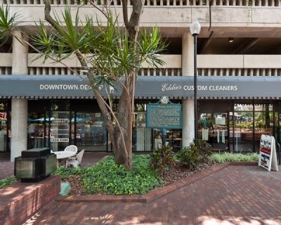
On North Franklin Street north of East Whiting Street, on the right when traveling north.
During the Second Seminole War (1835-42) the U.S. Army established a cemetery at this site for soldiers, civilian employees, and Indians. In 1883, about 20 soldiers were removed to Barrancas National Cemetery, Pensacola. In time the grave sites . . . — — Map (db m44689) HM
On East Street, on the right when traveling north.
At this site, 407 East Street, was the home of John Thomas Lesley, built in 1897. Pioneer settler, soldier, statesman and entrepreneur, Lesley (1835 - 1913) was one of Tampa's greatest early leaders/ A native of Madison County, Florida, he came in . . . — — Map (db m54132) HM
On South Franklin Street south of East Whiting Street, on the right when traveling north.
Side 1
Commanded from here, 1838-1840
the United States Army
in the 2nd Seminole Indian War
Erected by the Hillsborough County Historical Commission 1966
Monument restored by Hart with the Streetcar Extension in 2010
. . . — — Map (db m103266) HM
Near North Franklin Street north of East Whiting Street, on the right when traveling north.
On this site was located the first cemetery for Fort Brooke, a U.S. military post dating from 1824 to 1882. Seminole Indians, soldiers and civilian settlers buried here were excavated by archaeologists in 1980 prior to construction of the parking . . . — — Map (db m44377) HM
On Bayshore Boulevard at Hyde Park Place, on the right when traveling north on Bayshore Boulevard. Reported permanently removed.
Fort Brooke (Tampa)
Established 1824 by Col. George M. Brooke 4th US Infantry, east bank Hillsborough river. Prominent as Army Headquarters Seminole Indian Wars of 1835-42 & 1855-58.
Confederate Battery
A parapet mounted by three . . . — — Map (db m130076) HM
On East 8th Ave near Angel Oliva Senior Street, on the right when traveling west.
The Old Military Road connecting Ft. Brooke (Tampa) and Ft. King (Ocala) ran through this vicinity. On Dec. 23, 1835, Maj. Francis L. Dade set out over the Trail with a detachment of 109 soldiers to reinforce the small garrison of Ft. King.
On . . . — — Map (db m126035) HM
On North 13th Street at East 5th Avenue, on the left when traveling south on North 13th Street. Reported missing.
For centuries, Tocobaga Indians drew water from this deep natural spring. When U.S. Army troops arrived in 1824, they quickly discovered this natural resource. Twice a day, government wagons hauled water to Fort Brooke. Despite a strong taste of . . . — — Map (db m130374) HM
Old Fort King Trail is near the original Fort King Road. During the Second Seminole War, Fort King Road served as the main transportation and communication route between Fort Brooke (Tampa) and the Seminole Agency at Fort King (Ocala). Following an . . . — — Map (db m126033) HM
On State Road 60 (State Road 60) 0.6 miles east of 130th Avenue, on the right when traveling east.
A few miles southwest of this marker is the site of Fort Vinton. As white settlers moved into Florida, demands increased for the removal of the Seminole Indians to a western reservation. The Seminoles did not wish to leave, and in 1835 the conflict . . . — — Map (db m212677) HM
Near Florida Route 2 1 mile east of Timberlake Road, on the right when traveling east.
Creek Town of the Spanish Era
Ekanachatte ("Red Ground") was an important Creek Indian town that stood here at Neal's Landing Park during the latter half of the 18th century and the first two decades of the 19th.
This site was known as . . . — — Map (db m201244) HM
On Blue Hole Drive 1 mile west of Caverns Road, on the right when traveling west.
American desire for the acquisition of Florida grew after 1800 as U.S. frontiers expanded. Border incidents provided motivation for General Andrew Jackson's 1818 expedition against Florida's Seminole Indians. Jackson's army destroyed Indian . . . — — Map (db m167155) HM
On State Road 40 0.3 miles west of the Astor Bridge, on the right when traveling east.
Located on the west bank of the St. Johns, Ft. Butler was built in 1838 during the Seminole Wars. It consisted of a crude log stockade and barracks for the garrison. The Fort was one of the military installations designed to protect the St. Johns . . . — — Map (db m31341) HM
On South Central Avenue (State Road 19) at Golden Gem Drive, on the right when traveling north on South Central Avenue.
During the Second Seminole War (1835-1842), troops under the command of Brig. Gen. Abraham Eustis left Volusia County headed toward the Withlacoochee River as part of a military action in response to the December 28, 1835 massacre of Major Francis . . . — — Map (db m56224) HM
On Cape Coral Parkway East 0.2 miles east of Southeast 17th Place, on the right when traveling west.
Near here on the Caloosahatchee River a band of 160 Indians attacked the Fort and Trading Post at four o'clock on the morning of July 23, 1839. In the raid led by Chief Chekaika of the Spanish Indians, thirteen soldiers died and fourteen, including . . . — — Map (db m127695) HM
On First Street (Florida Route 80) at Jackson Street, on the left when traveling west on First Street. Reported missing.
Army Post Ft. Myers was established 14 February 1850 with 116 men and officers. Winfield Scott Hancock, Q.M. Captain was assigned in 1856. During the last years of the Seminole War there were 835 personnel in residence. The fort was deactivated in . . . — — Map (db m315065) HM
On Blountstown Highway (State Road 20) 0.1 miles Five By Five Drive, on the right when traveling east.
Fort Braden was established in 1839 as a military outpost during the Second Seminole War (1835-1842). At the end of the war the fort was abandoned, but the small farming community that had developed nearby continued. A school in the Fort Braden area . . . — — Map (db m79475) HM
Mission San Luis de Talimali was among the largest and most important missions in Spanish Florida. Its parishioners were Apalachee Indians who were descendents of those people whose village Hernando de Soto appropriated during the winter of . . . — — Map (db m79564) HM
A life-sized, cast-bronze sculpture, designed and created by the artist team of Bradley Cooley and Bradley Cooley Jr. of Lamont, Florida, shows a typical family during the Seminole Wars of the 1830s. Under constant threat from the U.S. military, . . . — — Map (db m299189) HM
Near South Pedrick Road 0.7 miles east of Stoney Creek Way.
Green Hill Chaires, along with his brothers, Benjamin and Thomas Peter,
came from Georgia to Tallahassee in the 1820s. Because of federal efforts
to both remove Indigenous people from the newly acquired Florida territory,
and laws legalizing . . . — — Map (db m297503) HM
On Monroe Street at Apalachee Freeway on Monroe Street.
This monument is erected by his fellow citizens of Leon County, Florida, as a testimonial of their high esteem for his character and public services. The memory of the hero is the treasure of his country. He was born July 10, 1823 and was killed . . . — — Map (db m73046) HM
On E. Park Avenue at S. Monroe Street, in the median on E. Park Avenue.
The oldest public building in Tallahassee. Construction was begun in 1835 and completed in 1838. Contains original slave galleries. The building was used many times as a place of refuge for women and children during Indian Wars. — — Map (db m73053) HM
On Pisgah Church Road 0.1 miles east of Shady Lane, on the right when traveling west.
To the west, on the large curve of the road, was once the community of
Centerville. In the 1820s, German immigrants Conrad Houck and Jacob
Horger, living in Orangeburg, South Carolina, purchased land northeast of
the newly established Florida . . . — — Map (db m297507) HM
On Chaires Cross Road (State Road 154) 0.2 miles west of Parkhill Road, on the right when traveling east.
The community of Chaires was established in the 1820s during Floridas Territorial Period (1821-1845). The community is named after Green Hill Chaires, who, along with his two brothers, Benjamin and Thomas Peter, came from Georgia and established . . . — — Map (db m166852) HM
On U.S. 90 0.1 miles west of Northwest Elizabeth Sims Loop, on the right when traveling east.
The Miccosukee Indian chief, John Hicks (English name for Tuckose Emathla) was a prominent Indian leader in the period between the First and Second Seminole Wars (1818-1835). It is believed that after General Andrew Jackson destroyed the . . . — — Map (db m210908) HM
On East Base Street (U.S. 90) east of Northeast Range Avenue, on the right when traveling west.
On this site stood a Blockhouse erected by the citizens of the area to protect women, children, and old people in the threatening period of 1835-1842. It served as an informal Court House before Adoniram Vann completed the regular Court House in . . . — — Map (db m149386) HM
Near Fort Hamer Road 0.1 miles south of Rive Isle Run.
Near this location stood Fort Hamer, a Second Seminole War fort and hospital that stood on the south bank of the Manatee River at the highest point navigable by steamboats. The fort was part of a greater U.S. military strategy of a line of forts . . . — — Map (db m239222) HM
Near Fish Hook Cove 0.3 miles north of Waterlefe Boulevard, on the left when traveling north.
(side 1)
A frontier military post once stood a mile northeast of this marker on the south bank of the Manatee River. The fort was built during the Seminole Scare of 1849 and named for Brig. Gen. Thomas L. Hamer, who died in 1848 in the . . . — — Map (db m280652) HM
Near 119th Street W. south of Cortez Road W. ( Highway 684), on the left when traveling south.
Local resources and environment affected how Native tribes built their houses. Some dwellings were circular, with clay or mud applied to a frame of woven branches. Others were pyramid-shaped, with a log frame covered from top to bottom with palm . . . — — Map (db m311065) HM
On Bayshore Drive at Boots Point Road, on the left when traveling north on Bayshore Drive.
Side 1:
Miguel Guerrero (aka Gerrero), a Menorcan sailor (b. 1817), established a fishing rancho here at Boots Point in 1848 on the site of a prehistoric Indian village. In 1856, Miguel met Julia Atzeroth's niece, Frederica Kramer (b. . . . — — Map (db m241682) HM
Near East Fort King Street at SE 39th Terrace, on the left when traveling east.
In 1823, the Treaty of Moultrie Creek allocated land to the Seminole with the northern-most boundary of the reservation ending at what would soon be known as Fort King. Due to the growing friction between the Seminole and white settlers, the . . . — — Map (db m201370) HM
Near East Fort King St at SE 39th Avenue, on the left when traveling east.
December 28, 1835
The start of the Second Seminole War:
The second attack on that deadly day
Attack on Fort King
The same day as the Dade Massacre, the Fort King Indian Removal Agent, General Wiley Thompson, was anticipating . . . — — Map (db m201752) WM
Near East Fort King Street 0.1 miles south of East Silver Springs Boulevard.
Dade Massacre
Dec. 28, 1835
Major Francis L. Dade and 110 men were attacked six miles north of Withlacoochee River. Four survived and one lived to tell the story. Troop was en route to Ft. King.
Same day, Gen. Thompson and . . . — — Map (db m198813) HM WM
December 28, 1835
The start of the Second Seminole War:
The first attack on that deadly day
Dade Massacre
On December 23, 1835, two companies of U.S. troops were dispatched from Fort Brooke in Tampa under the . . . — — Map (db m201516) HM
Near East Fort King Street 0.1 miles south of East Silver Springs Boulevard.
Florida Armed Occupation Act
8-4-1842 • 238 Signers
East of base line near Fort King a quarter
section of land for the head of a family,
or a single man over eighteen years of
age, able to bear arms
Sponsored by: . . . — — Map (db m198634) HM WM
Near Southeast 80th Street (County Road 328) at South Pine Avenue (U.S. 441), on the right when traveling east.
Some of the early migrants to the Greenway were known for whips and storytelling. Discover what happened. Discover The Island. Florida’s Crackers were mostly, it's said to be, English pioneer settlers and their descendants who began coming to . . . — — Map (db m167205) HM
Near Southeast 80th Street (County Road 328) at South Pine Avenue (U.S. 441), on the right when traveling east.
Florida Seminole. After the Third Seminole War (1858), nearly 3,000 Indians were forcibly sent to the Oklahoma Territory. A small number of Seminoles continued to live in relative isolation in southern Florida into the 1900s. Flood control and . . . — — Map (db m167203) HM
Near Southeast 80th Street (County Road 328) at South Pine Avenue (U.S. 441), on the right when traveling east.
Early Migrants More Than Snowbirds The earliest migrants to Florida, determined by archeological evidence, date back to 500 A. D. Among them were the Deptford People, the Weeden Island People, the St. John's People and the Timican . . . — — Map (db m167202) HM
Near East Fort King Street 0.1 miles south of East Silver Springs Boulevard.
Fort Brooke - Tampa, Florida in 1847 & 48 two infantry companies of Florida volunteers restrained the Indians in South Florida while three infantry companies of volunteers went to the Mexican American War.
Dedicated to my great, great . . . — — Map (db m199009) WM
Near East Fort King Street 0.1 miles south of East Silver Springs Boulevard.
Built near Silver Springs 1827 to protect the United States frontier in Florida and named after COL. William King, Civil Military Governor of west Florida. December 1835, General Wiley Thompson was killed near Fort King, diseases killed many . . . — — Map (db m198857) HM WM
Near East Fort King Street at SE 39th Avenue, on the left when traveling east.
Fort King was a typical U.S. Army frontier fort and a noteworthy symbol of the longest and costliest war America had with its native people - the Seminole War. Fort King is a narrative that speaks of a complicated history as relates to the . . . — — Map (db m201351) HM
On East Fort King Street at Southeast 39th Terrace, on the right when traveling west on East Fort King Street.
On a nearby knoll stood Fort King, important military outpost during the removal of the Florida Indians. Adjacent to a Seminole agency established in 1825, it was named for Col. William King and first occupied in 1827. Outside the stockade, on . . . — — Map (db m150855) HM
In the 1800’s,communication, supply delivery and trade between the Indian Agencies, Seminole and U.S.
Army forts proved to be challenging due to the lack of a clear path or road. In many cases forests, difficult or impassable terrain and . . . — — Map (db m201485) HM
Near East Fort King Street at SE 39th Avenue, on the left when traveling east.
Life at Fort King would not have been easy for soldiers accustomed to a northern climate and more civilized setting. They would have experienced extreme heat and encountered insects and animals they were unfamiliar with. The soldiers' uniforms . . . — — Map (db m202035) HM
Near Southeast 80th Street (County Road 328) at South Pine Avenue (U.S. 441), on the right when traveling east.
Oklahoma Seminoles. The Seminole Nation in the State of Oklahoma is the largest of the three recognized Seminole governments in the United States. They are descendants of the 3,000 Seminoles who were forcibly removed from Florida in the middle . . . — — Map (db m167204) HM
On East Fort King Street 0.1 miles south of East Silver Springs Boulevard.
1st. Seminole War: 1817 - 1818
Warfare in south GA & Florida
Gen. Andrew Jackson led U.S. troops. Seminoles
we’re called Micos and we’re quickly defeated.
Spain ceded Florida to U.S. in 1821
2nd. Seminole War: 1835 . . . — — Map (db m198855) WM
Near East Fort King Street at SE 39th Terrace, on the left when traveling east.
Several years after the conclusion of the War of 1812, the U.S. military began excursions into the Spanish owned territory of Florida. General Andrew Jackson ordered his military to invade and destroy the “Negro Fort” on the Apalachicola River . . . — — Map (db m201473) HM
Near East Fort King Street at SE 39th Terrace, on the left when traveling east.
The Second Fort
Amidst growing hostilities with the Seminole, the U.S. Army reconstructed Fort King in 1837 and continued its use until the termination of the war. Unlike the first fort, the second fort appears to have been constructed in . . . — — Map (db m201408) HM
Near East Fort King Street at SE 39th Avenue, on the left when traveling east.
The Second Seminole War
After years of managing conflicts between the American settlers and Native Americans all along the east coast, the United States government passed the Indian Removal Act of 1830 which sought to relocate all . . . — — Map (db m201594) HM
Near East Fort King Street at SE 39th Terrace, on the left when traveling east.
The Seminole Wars, also known as the Florida Wars, were three related military conflicts in Florida between the Seminole and the United States. Many consider them one conflict called The Seminole War.
There is no absolute consensus to . . . — — Map (db m201430) HM
Near East Fort King Street at SE 39th Avenue, on the left when traveling east.
Shortly after Florida became American Territory, the conflict between the United States and the Seminole began to escalate. In 1823, the United States and the Seminole entered into an agreement known as The Treaty of Moultrie Creek.
The . . . — — Map (db m201600) HM
After George Washington disbanded the Continental Army in 1783, the United States Army had been reduced to 80 men under a captain guarding the arsenals at two forts. To many members of Congress, a standing army was viewed as a threat to . . . — — Map (db m201667) HM WM
Near East Fort King Street at SE 39th Avenue, on the left when traveling east.
In 1828, Andrew Jackson was elected President of the United States, in 1830, Congress passed and President Jackson signed into law the Indian Removal Act, which called for the relocation of all Native Americans to west of the Mississippi River the . . . — — Map (db m201518) HM
Near East Silver Springs Boulevard at NE 58th Avenue, on the right when traveling east.
Early Human Inhabitants
People first reached Florida at least 12,000 years ago. Many native tribes utilized the natural resources.
European Exploration and Colonization
Written records about life in Florida began with the . . . — — Map (db m310929) HM
Near Northeast 29th Place 0.5 miles south of East Silver Springs Boulevard (State Highway 40).
October 23, 1834, the Seminole Indians met in council at these springs to discuss demands of the United States for their removal to the West. Osceola, then an obscure sub-chief, swayed the council with his oratory and set the Indians against . . . — — Map (db m132200) HM
Near East Silver Springs Boulevard (Florida Route 40) at NE 57th Avenue, on the right when traveling east.
Timucuans At least 12,000 years ago, people who later became known as the Timucuans, in the Ocali province, were living here hunting large animals such as mastodon and giant sloths. At that time, the climate was much cooler and drier, sea level . . . — — Map (db m225879) HM
Near Cape Florida Park Boulevard at South Crandon Boulevard, on the left when traveling south.
The Cape Florida Lighthouse stands today as a reminder of perseverance in the face of hardship.
The Cape Florida Lighthouse was built to alert ships as they sailed near the dangerous reefs of the Florida Keys.
Constructed in December . . . — — Map (db m79720) HM
On Cape Florida Park Boulevard south of Crandon Boulevard.
The original brick dwelling was completed in July 1825: a two story cottage with two rooms on each floor. The lower floor was dirt and the upper floor had only one small window on each end. The kitchen was attached to the back. The first . . . — — Map (db m80255) HM
Near Northwest North River Drive at Northwest 3rd Street, on the right when traveling north.
The United States of America took possession of Florida from Spain under the terms of the 1821 Treaty of Paris. In 1830, the U.S. implemented the Indian Removal Act, forcing Seminole Indians south into the Miami and Everglades area. The Second . . . — — Map (db m78126) HM
Near Virginia Beach Drive 0.4 miles north of Rickenbacker Causeway (State Road 913), on the right when traveling north.
Virginia Key Beach Park is an environmental and historic landmark located on a barrier island. Its earliest recorded history is of an 1838 skirmish during the Second Seminole War in which three Seminoles were killed on this site. From the early . . . — — Map (db m79381) HM
Near Northwest North River Drive at Northwest 3rd Street, on the right when traveling north.
This 1850s structure is the oldest standing house in Miami-Dade County. It was built by William Wagner, a German immigrant and U.S. Army veteran. After being wounded in the Mexican-American War in 1847, Wagner returned to Fort Moultrie, Georgia to . . . — — Map (db m78192) HM
On West Flagler Street at NW Miami Court, on the left when traveling east on West Flagler Street.
Born 1793 in Virginia. Joined 12th U.S. Infantry in 1813; Served with it thru War of 1812; In 4th Regiment rest of his life. Promoted from 3rd Lieut. to Major, Commanded garrison at Key West. In Seminole War was sent with 117 men to aid Gen. Clinch . . . — — Map (db m88531) HM
On South Dixie Highway (U.S. 1) at SW 160th Street, on the right when traveling north on South Dixie Highway.
(side 1)
In 1838, the United States Congress granted a township of land in the southern extremity of Florida to noted horticulturist Dr. Henry Perrine and his associates. This land was to be used in experiments aimed at introducing foreign . . . — — Map (db m73442) HM
On Overseas Highway (U.S. 1 at milepost 79), 0.3 miles north of Davis Lane, on the right when traveling south.
Native Americans began occupying Indian Key by approximately A.D. 1000. It was visited by the Spanish during the 17th century, and a trading post had been established on the island by the early 19th century.
The island was acquired by Jacob . . . — — Map (db m224711) HM
Near Overseas Highway (U.S. 1) north of North Ocean Lane (County Route 931), on the right when traveling south.
When the Europeans arrived in America, two tribes of Indians were found in Florida, the Calusa and the Tequesta. These tribes emerged from the Archaic Period (the time when Florida became subtropical, around 5000 B.C.). The Calusa was the largest . . . — — Map (db m222295) HM
On Overseas Highway (U.S. 1 at milepost 71), 1.5 miles south of Old State Road 4a, on the left when traveling south.
Indians lived on this island over 1000 years ago. In 1722, it was known as Boys Island. In Dec., 1838, Lt. Coste established a Naval base here and named it Ft. Paulding. This was the base for the West Indian Squadron used to blockade the coast to . . . — — Map (db m176362) HM
On Overseas Highway (U.S. US1 at milepost 79), 0.3 miles north of Davis Lane (Local Route 961), on the right when traveling south.
Like nearby Upper and Lower Matecumbe and Indian Keys, Tea Table Key was occupied by native Americans during prehistoric times. The early inhabitants settled here to take advantage of the abundance of maritime resources available in the area. . . . — — Map (db m224714) HM
Second Seminole War
Enraged by the government's imminent deadline for their removal to western reservations, Florida Indians launched attacks on military units and outlying plantations in December 1835.
First news of the attacks . . . — — Map (db m224141) HM WM
Interesting Details about Zachary Taylor
• In 1837, He was promoted to Brigadier General and earned the nickname, "Old Rough and Ready"
• Zachary Taylor was the second President to die in office. Within months of his death, this fort, . . . — — Map (db m240143) HM
On Southeast 38th Avenue 0.2 miles north of U.S. 98/441, on the right when traveling north.
In these woods on Christmas Day 1837, was fought the Battle of Okeechobee, in which a large band of Seminole Indians, under Chief Wild Cat, Alligator, and Sam Jones was routed by a brigade led by Colonel Zachary Taylor, consisting of the First, . . . — — Map (db m97075) HM WM
Near Southeast 38th Avenue 0.2 miles north of U.S. 98/441, on the right when traveling north.
The Second Seminole War
In 1830, President Andrew Jackson authorized the removal of eastern Native American tribes to west of the Mississippi River. The US government and some Seminole chiefs discussed the removal, though details of an . . . — — Map (db m220348) HM
On Southeast 38th Avenue 0.2 miles north of Route 98/441, on the right when traveling north.
The Battle of Okeechobee Historic State Park is located on a portion of the actual battleground of the Second Seminole War's fiercest battle. Federal and volunteer soldiers, led by colonel Zachary Taylor, were part of a large army attempting to . . . — — Map (db m220350) HM WM
On Southeast 38th Avenue 0.2 miles north of U.S. 98/441, on the right when traveling north.
The Okeechobee Battlefield Historic State Park is truly hallowed ground on which the great patriots and warriors who so valiantly fought in this battle are honored and memorialized with the dignity they so richly deserve. The Okeechobee . . . — — Map (db m220351) HM WM
Near North Fort Christmas Road 0.1 miles north of Christmas Cemetery Road, on the left when traveling north.
The blockhouses served as lookouts, headquarters of General Thomas S Jesup, and protection of the troops in the event of an Indian attack. Two blockhouses were constructed on opposite corners of the stockade twenty (20) feet square with four (4) . . . — — Map (db m208578) WM
Near North Fort Christmas Road 0.1 miles north of Christmas Cemetery Rd, on the left when traveling north.
The blockhouses served as lookouts, headquarters of General Thomas S. Jesup and protection of the troops in the event of an Indian attack. Two blockhouses were constructed on opposite corners of the stockade, twenty feet square with four feet . . . — — Map (db m208610) HM
Near North Fort Christmas Road (State Road 420) 1.8 miles north of East Colonial Drive (State Road 50).
As white settlers moved into Florida in the 1820's and 1830's, there were growing demands that the Seminole Indians be removed to a reservation west of the Mississippi. Efforts to convince the Seminoles to move failed, and in 1835 the conflict known . . . — — Map (db m54086) HM
Near North Fort Christmas Road 0.1 miles north of Christmas Cemetery Road, on the left when traveling north.
The powder magazine was used for storing ammunition and was below ground level for safety. Should the powder explode the energy from the blast would be sent mostly upward into the air, not outward destroying the Fort and causing injury to the . . . — — Map (db m208603) HM
Near North Fort Christmas Road (County Route 420) 0.1 miles north of Christmas Cemetery Road, on the left when traveling north.
During the Second Seminole War General Eustis, U.S. Army, under the command of General Thomas S. Jesup, moved a column south from Fort Mellon (Sanford, Florida) on the 17th of December 1837. The column consisted of the 3rd Regiment of Artillery, 4 . . . — — Map (db m208532) HM
On South Conway Road (State Road 15) at Gatlin Avenue, on the right when traveling south on South Conway Road.
Conway First Baptist Church
The Conway First Baptist Church was organized in 1910 and first housed in a clubhouse on Arnold Avenue and Anderson Road. In February 1911, the clubhouse and lot were sold or exchanged for five acres of land . . . — — Map (db m101052) HM
On S. Orlando Avenue (U.S. 17 & 92) at Lake Lily Drive, on the right when traveling north on S. Orlando Avenue.
Fort Maitland
was built in November 1838 by Lt. Col. Alexander C. W. Fanning, U.S.A. (1788-1848) on the military road connecting Fort Melon (Sanford) with Fort Gatlin (Orlando) and used as a stockade in the war between the United States and the . . . — — Map (db m7452) HM
On Lake Lily Drive west of South Orlando Avenue (U.S. 17/92), on the right when traveling west.
The historic road around Late Lily was first used as a Native American path. During the Second Seminole War, it became a military supply route between Fort Mellon (now Sanford) and Fort Gatlin (now Orlando.) Ft. Maitland (located East of the park) . . . — — Map (db m197016) HM
This road was the first direct route from Northeast Florida to Maitland. It followed Maitland Avenue around this west side of Lake Lily and continued south on what is now Highway 17-92. During the Second Seminole War the United States Army used this . . . — — Map (db m13636) HM
On Gatlin Avenue at South Summerlin Avenue, on the left when traveling east on Gatlin Avenue.
On November 9, 1838, during the Second Seminole Indian War (1835-42), the U.S. Army established Fort Gatlin in Mosquito County. This fort was named for Army Assistant Surgeon John S. Gatlin (1806-1835), who was killed in the Dade Massacre in 1835. . . . — — Map (db m6912) HM
On Kempfer Road south of E. Bronson Highway (U.S. 192), on the left when traveling south.
Fort Taylor was named after U.S. Army General Zachary Taylor, who later became the 12th President of the United States. Fort Taylor was built in 1837 during the second Seminole War (1835-1842). It was one of a series of four forts built along the . . . — — Map (db m221630) HM
On Tallahassee Boulevard south of Old Tampa Highway, on the right when traveling south.
Fort Davenport was built for service during the Second Seminole War (1835-1842). This fort was one of a series of forts constructed for use during the war, it was used to protect supplies and garrison troops.
Fort Davenport (1839) was located . . . — — Map (db m216049) HM
Near Lakeview Drive at Ruby Avenue, on the right when traveling north.
The City of Kissimmee rests on the northern shore of the historic Lake Tohopekaliga. This vast lake, almost 19,000 acres, is connected to the Kissimmee Chain of Lakes. Lake Toho, as the locals call it, has played an important role to Kissimmee both . . . — — Map (db m206105) HM
On Old Dixie Highway (State Road 811) 0.2 miles south of Federal Highway (U.S. 1), on the right when traveling north.
Fort Jupiter was located three miles west on Loxahatchee River, erected January 1838 by troops commanded by Major General Thomas S. Jessup, establishing base for operations in the Seminole Indian Wars. Jupiter Lighthouse, approximately one mile . . . — — Map (db m96947) HM
Near West Indiantown Road (State Road 706) 1.3 miles west of Florida's Turnpike (Interstate 95), on the left when traveling west.
On January 24, 1838, Major General Thomas S Jesup, commanding 1,500 men, the largest army of Second Seminole War (1835-42), marched to the headwaters of the Loxahatchee River, where he defeated approximately 300 Red and Black Seminoles in the last . . . — — Map (db m99904) HM
On Clocktower Drive at West Indiantown Road (State Road 706), in the median on Clocktower Drive.
After the second Battle of the Loxahatchee (January 24, 1838) during the Second Seminole War (1835-1842), Maj. Gen. Thomas S. Jesup directed Maj. William Lauderdale, Commander of the Tennessee Battalion of Volunteers to cut a trail south from Ft. . . . — — Map (db m97073) HM
Near West Indiantown Road (State Road 706) 1.3 miles west of Florida's Turnpike (Interstate 95), on the left when traveling west.
On January 15,1838, during the Second Seminole War.The Seminoles met and defeated U.S. forces in the first battle of the Loxahatchee River.Trying to end the war,Maj. Gen. Thomas Jesup brought several columns of troops to south Florida, including . . . — — Map (db m99906) HM
On Jupiter Lighthouse Park west of Coast Guard Way, on the right when traveling east.
For centuries, the Native Americans who became Seminoles enjoyed this area. Once a peaceful wilderness, they named the river we now call Loxahatchee the "Locha Hatchee or Turtle River. During the Seminole Wars (1818-1858), the brilliant Seminole . . . — — Map (db m213652) HM
On Winding Lake Drive 0.1 miles east of Cassie Holy Court, on the right when traveling east.
During the 2nd Seminole Indian War and after the Battle of Loxahatchee Jan. 24, 1838, the Tennessee Volunteers and Militia camped on this site. One mile east, the U.S. Army Regulars established Old Fort Jupiter. — — Map (db m96969) HM
On Jupiter Lighthouse Park at Coast Guard Way, on the right when traveling east on Jupiter Lighthouse Park.
"Chickee” is the Seminole word for house. This one was built by Jim Billie, Chairman of the Seminole Tribe of Florida. The structure represents a significant era in the history of the Seminole and Miccosukee Tribes of Florida. Hunted by U.S. . . . — — Map (db m213653) HM
On Jessamine Road 1.5 miles south of Blanton Road (County Route 41), on the right when traveling west.
The former town of Chipco was located here, less than six miles west of the former site of Fort Dade #2, built in 1849 during the Seminole War era. The town rose to prominence after the Civil War as an economic center. It was named in honor of Chief . . . — — Map (db m146964) HM
On Fort King Road just north of Grassy Hill Lane, on the right when traveling south.
On Christmas Day, 1835, Major Francis Langhorne Dade and his command of 111 men bivouacked near here by Fort King Road, which stretched 125 miles from Fort Brooke (Tampa) to Fort King (Ocala). Three days later, at a point about twenty miles north of . . . — — Map (db m136460) HM
On U.S. 98/301 at Bluegrass Road, on the right when traveling north on U.S. 98/301. Reported missing.
Construction on Fort King Road, first known as the Military Road, was begun in 1825 north from Fort Brooke at Tampa Bay. By the 1830’s penetration had been made to Fort King near present-day Ocala, and the road assumed strategic military importance. . . . — — Map (db m129360) HM
On Withlacoochee Boulevard 0.1 miles south of River Road, on the right when traveling east.
The first bridge crossing the Withlacoochee River at this site was built in the 1850s by slaves belonging to James Lanier. Replaced several times during the following century, the bridge served lumber, turpentine and cattle operations along with . . . — — Map (db m213957) HM