On West Main Street west of South 1st Avenue, on the right when traveling east.
Oldham was the 75th county created by the Kentucky Legislature. It was formed on January 15, 1824, from portions of Jefferson, Henry and Shelby Counties. The county is named for William Oldham, Revolutionary War patriot and early pioneer.
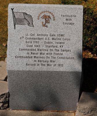
. . . — — Map (db m136163) HM
On River Road (State Highway 942) at St. Elmo Street (Parish Route 1435), on the right when traveling south on River Road.
Built in 1801 by Marius Pons Bringier as wedding gift for daughter Fanny, who married Christophe Colomb, a French refugee. Remodeled by Architect James Dakin 1837. Restored by Dr. & Mrs. E.G. Kohlsdorf 1941. — — Map (db m85285) HM
On this site stood the Spanish Fort captured by the forces of the Republic of West Florida September 23, 1810. Erected by the Historical Society of East & West Baton Rouge January 16, 1917 in celebration of the centennial of the City — — Map (db m242219) HM
On Auburn Riverwalk just east of Main Street (Maine Route 136), in the median.
Wabanaki History: From Amitgonpontook to Lewiston-Auburn
During the 1680s several hundred Wabanakis fled the English wars of conquest in the south and gathered here at the town of Amitgonpontook. Nearby fish, farm crops, and . . . — — Map (db m185978) HM
On Blockhouse Road at Island Road, on the right when traveling west on Blockhouse Road.
The Aroostook War was an undeclared, bloodless “war” that occurred in 1839.
The peace treaty that ended the American Revolution in 1783 had not satisfactorily determined the boundary between New Brunswick and what is now Maine.
The . . . — — Map (db m102463) HM
On Cumberland Avenue just south of Boyd Street, on the right when traveling south.
This memorial is dedicated to the survivors of the Armenian Genocide 1915 - 1923, who settled in Bayside by the early twentieth century over 250 Armenian families lived in Porland where they established businesses and a vibrant social . . . — — Map (db m186405) HM
On Maryland Avenue south of Prince George Street, on the right when traveling north.
Design
The black and gold design on the flag is the coat of arms from the Calvert line. It was granted to George Calvert as a reward for his storming a fortification during a battle. The red and white design is the coat of arms of the . . . — — Map (db m114857) HM
Near Silver Spring Drive east of African Journey, on the left when traveling north.
It is difficult to know how many okapi are still living in Congolese rainforests, but by all estimates, their numbers are declining. To save okapi, we need to preserve and protect their shrinking habitat.
Okapi population decline
2000: . . . — — Map (db m189106) HM
On Swann Drive, on the right when traveling north.
"Guardian of Scotland" Scottish Wars of Independence Presented to the people of Baltimore by William Wallace Spence November 30, 1893 Re-dedicated on August 22, 1993 by the St. Andrew's Society of Baltimore
"It is in truth not for glory, nor . . . — — Map (db m7596) HM
On President Street at Aliceanna Street, in the median on President Street.
Fire has been used artistically to symbolize a rebirth or transformation in this monument a symbolic fire envelops the Katyń martyrs in its flames and raises them spiritually into the pantheon of national heroes of Poland.
The . . . — — Map (db m183379) HM
On Pershing Drive at Bonifant Street, on the left when traveling west on Pershing Drive. Reported damaged.
This mural tells the stories of 3 refugees who live here in Maryland, who were interviewed for this project. Georges, a former mayor of his city in eastern Congo (DRC), fled with his family when the war came to his region. Mai, from Myanmar (aka . . . — — Map (db m114527) HM
On Middle Street Path just north of Aldermanbury Street Footpath, on the left when traveling north.
Civil war raged in England during the 1640s between King Charles I and his opponents in Parliament. Maryland's proprietary government, led by Lord Baltimore and other Catholics, sided with the King. Many of the first colonists in Maryland, however, . . . — — Map (db m138837) HM
Near Old State House Road at Point Lookout Road (Maryland Route 5).
Margaret Brent (ca. 1601–1671), a Catholic gentlewoman, lived in Maryland from 1638 to 1650. In June 1647 the dying governor, Leonard Calvert, made her executrix of his estate with power to pay the soldiers he had hired to put down a Protestant . . . — — Map (db m950) HM
On 24th Street just east of Philadelphia Avenue (Maryland Route 528), on the right when traveling east.
World War II was the last fought in which the President asked Congress for a declaration of war. Since then, United States armed forces have been in combat, including these smaller conflicts:
Cuba 1961
The U.S. orchestrates the . . . — — Map (db m150158) HM
On Massachusetts Avenue (Massachusetts Route 2A) south of Church Street, on the right when traveling south.
Richard T. Greener, the first African American to graduate from Harvard College, had a distinguished career in public service.
Greener was born in Philadelphia. His father, a sailor, disappeared in the Gold Rush in 1853. The family moved to . . . — — Map (db m215383) HM
The monument on the left honors three residents killed in Korea and one lost in Iraq.
Howard Francis Heyliger •
James Edward Smith Jr. •
Wilfrid Wheeler, III •
Brian M. McPhillips
The monument on the right honors five killed in Vietnam . . . — — Map (db m107681) HM WM
Near Monument Street north of Center Street, on the right when traveling north.
Hermann (Arminius) of the Cherusci tribe led several German tribes in battle against their Roman conquerors in 9 A.D., and defeated them in the hills of Teutoburg Forest near present Detmold. To later unified Germany, Hermann . . . — — Map (db m65467) HM
Near State Highway 55 north of State Highway 5, on the right when traveling north.
An Appreciation
He served with distinction in the Indian wars of the old northwest border and in the War of 1812. In August, 1820, he assumed command of the Fifth United States Infantry at Camp Coldwater on the site of Fort Snelling. Selecting the . . . — — Map (db m227949) HM
Near this spot, in 1783, a young Ojibwe boy named Esh-ke-bug-e-coshe (Flatmouth) crouched behind a trading post's log barricade on this wah de nah (sloping or little round hill) while Dakota arrows fell "as thick as snowflakes" around him.
A . . . — — Map (db m93189) HM
Near St. Crois Trail North (State Highway 95) 0.1 miles north of Laurel Street East, on the left when traveling north.
In this ravine at daybreak July 3, 1839, a war party of Sioux overtook a body of Chippewa returning from Fort Snelling where a Sioux had been killed by another Chippewa. A bloody battle took place in which the Chippewa losses were about 50 killed . . . — — Map (db m207756) HM
Near Wells Drive, 0.1 miles west of Concourse Drive, on the right when traveling west.
Too Close for Comfort
Habitat destruction has forced gorillas to live closer to human settlements. Since gorillas and humans share most genes, we also share most diseases. Outbreaks of Ebola that have killed hundreds of people before being . . . — — Map (db m219002) HM
Near Shaw Boulevard west of Tower Grove Avenue, on the left when traveling west.
The "fleur-de-lis" is the symbol for Saint Louis and is thought to be the European and African yellow water flag, Iris pseudacorus. According to one legend, this iris helped save a French army in the 6th century from a hostile force that . . . — — Map (db m219275) HM
On Rue Saint Francois at Saint Ferdinand Street, on the right when traveling west on Rue Saint Francois.
King of Spain from 1217 to 1252, he was canonized by Pope Clement X in 1671. He was a capable and just administrator, spreading Christianity throughout his kingdom. He drove the Moors out of most of Spain, founded monasteries, established the . . . — — Map (db m149381) HM
Near Barrett Station Road east of Old Dougherty Ferry Road, on the right when traveling east.
This is a 2-10-0 decapod type freight locomotive built by Baldwin Locomotive Works for Imperial Russia, which contracted with Baldwin in 1915 for some 1,200 locomotives. Following the Russian Revolution, and therefore the inability to deliver these . . . — — Map (db m132951) HM
Near Cleveland Road (County Road 240) near S-B Road.
Striking on the run, the U.S. Army planned to surprise and overwhelm the Nez Perce camp. Along this ridge Nez Perce warriors fought back fiercely and stopped the cavalry charge. The surprise attack was blunted, but the Nez Perce were pinned down, . . . — — Map (db m142866) HM
On Front Street near 17th Street, on the right when traveling north.
Thomas Francis Meagher was born in Ireland in 1823. An Irish Revolutionary, he was caught and sentenced to death. Meagher's sentence was commuted to exile in Tasmania but he escaped to the United States. As a Brigadier General, Meagher commanded the . . . — — Map (db m142253) HM
(Three panels, presented left to right, form this marker.)
The Flight of the Nez Perce
In Search of Peace
In the mid-1870s the United States government attempted to force the Nez Perce (Nee-Mee-Poo or Nimiipu) people . . . — — Map (db m123125) HM
Built in 1908 as the University Library, this neoclassical building was Architect A. J. Gibson's fifth and final contribution to campus. In 1983 it was renamed in honor of 1902 graduate, suffragette and pacifist Jeannette Rankin (1880-1973). . . . — — Map (db m144098) HM
On U.S. 212 south of Big Powder River East, on the left when traveling north.
Fur trappers came upriver in the wake of the Lewis and Clark Expedition in 1806. These visitors left behind them tall tales of their adventures and a few trading posts scattered along the Yellowstone River. Southeastern Montana was Indian and . . . — — Map (db m189212) HM
On Rosebud Creek Road (County Road 447) 20 miles south of Interstate 94, on the left when traveling south.
When the Dakota Column arrived at the confluence of the Powder River and the Yellowstone, General Alfred Terry wanted to be certain that the Lakota had not moved south and east even though Gibbon's scouts had already located the big village on the . . . — — Map (db m189245) HM
On West Park Street, 0.1 miles west of Prince Street, on the left when traveling west.
The land at the confluence of Crosswicks Creek and the Delaware River was once part of a vast estate created by Joseph Bonaparte, elder brother of Napoleon. During Napoleon's brief reign as Emperor of France, Joseph was appointed King of Naples . . . — — Map (db m160165) HM
Near County Park Road, 0.3 miles west of North Main Street (U.S. 9), on the left when traveling west.
Characteristics: The bison has a long shaggy brownish black hair on its head, shoulders, neck and forelegs. The rest of the body is covered in shorter lighter hair. The head has a shaggy beard and a broad forehead with upturned horns. In the . . . — — Map (db m191001) HM
On Cambridge Street at North 6th Street, on the left when traveling east on Cambridge Street.
Co. B. 3rd Battalion, 75th
Ranger Regiment U.S. Army
Died in Mogadishu, Somalia
Mar. 31, 1972 - Oct. 3, 1993
Rangers lead the way — — Map (db m153784) WM
On Lamberton Street north of New Jersey Route 29, on the left when traveling north.
The English capture New Netherland, and King Charles II’s brother – James, Duke of York grants New Jersey to Sir George Carteret and John, Lord Berkeley. — — Map (db m211649) HM
On Lamberton Street north of New Jersey Route 29, on the left when traveling north.
Joseph Bonaparte, brother of Napoleon, flees Europe and settles in Bordentown, later occupying houses in today’s South Trenton and Hamilton Township — — Map (db m211741) HM
Born Liscannor, Ireland 1841
Died New Jersey, USA 1914
Designer of the U.S. Navy's first submarine
USS Holand (SS 1)
Dedicated Oct. 10, 1976 — — Map (db m145902) HM
On March 9, 1916, Francisco “Pancho” Villa, a major figure in the Mexican Revolution, crossed the international border with a large force, attacking and looting Columbus, New Mexico. Eighteen U.S. soldiers and civilians, and . . . — — Map (db m37776) HM
On Main Street (New York State Route 19) 0.1 miles north of Vandermark Road (County Road 10), on the right when traveling north.
The area around Scio was first settled around 1805 by Joseph Knight, a minuteman in the American Revolution. Knights Creek, which flows into the Genesee River near Scio, is named for him. Before getting its final name, Scio was called Bloods Corner . . . — — Map (db m175123) HM
Near Jungle World Road south of Bronx River Parkway, on the right when traveling south.
Père David's deer survive today thanks to over a century of careful conservation and caring individuals.
around 0 A.D. | Deer kept in Imperial Hunting Park in Nan Hai-Tze near Beijing.
around 200 A.D. | Deer presumed extinct in . . . — — Map (db m193268) HM
On Saint Ann's Avenue just north of La Lupe Way, on the right when traveling south.
In Memory of
Gouverneur Morris
The man whose hand wrote
the Constitution of the United States
Born January 31, 1752 - Died November 6, 1816
Interred in the Gouverneur Morris Tomb
In Stanns Churchyard
Washington's Minister to . . . — — Map (db m209730) HM WM
Devoted his life to the pursuit of social justice
through non-violent civil disobedience,
beginning in South Africa, then as a leader of the
independence movement in his native India.
He was assassinated as he tried to address the . . . — — Map (db m197899) HM
On Genesee Street at James Street, on the right when traveling east on Genesee Street.
The Medal of Honor is the highest military decoration awarded by the United States Government. It is bestowed by the President in the name of Congress and is conferred only upon members of the United States Armed Forces who distinguish themselves . . . — — Map (db m88220) WM
Sacred to the memory of
Samuel Neilson
An Irish patriot of 1798
One of the founders of the
United Irishmen
who sacrificed his fortune and his life
in the cause of his country
Born in County Down, Ireland, Sept 1761.
Died in . . . — — Map (db m210619) HM
On Thompson Park east of Thompson Blvd., on the right when traveling east.
The 10th Mountain Division (Light Infantry) was reactivated at Fort Drum on February 13, 1985. By 1988, with the support of Fort Drum's world class civilian workforce, the Division was manned, equipped, trained and certified as combat ready, As the . . . — — Map (db m179340) HM
We commemorate and honor the 100th anniversary of the men, women and children who gave
their lives for the Republic of Ireland in the 1916 Easter Rising — — Map (db m93302) WM
In Honor of the crew of the USS Liberty - AGTR 5, in recognition of their courageous and faithful service for military action on June 8, 1967
- The following decorations were awarded -
★ Congressional Medal of Honor ★
2 Navy . . . — — Map (db m90788) WM
In remembrance of the more than 200,000 women and girls who were abducted for the use of sexual slavery by the armed forces of the Government of Imperial Japan, 1930's-1945. Known to the world as "comfort women", they suffered heinous crimes . . . — — Map (db m106727) HM WM
On 59th Street at Avenue of the Americas, on the right when traveling west on 59th Street.
One of a trio of bronze equestrian sculptures representing Latin American leaders, the Simon Bolivar statue commemorates a military general and advocate of Pan-Americanism. Bolivar (1783-1840) is credited with the liberation from Spanish . . . — — Map (db m42569) HM
On Baxter Street, on the right when traveling south. Reported permanently removed.
Dr. Sun Yat-sen was born on November 12, 1866 to a Cantonese family in Tsuei-Heng Village, Shiangshan County, Kwangtung Province in China, under the rule of the Ching Dynasty. His early education in China, Hawaii and Hong Kong established him as a . . . — — Map (db m131336) HM WM
On Mulberry Street just south of Bayard Street, on the left when traveling north.
Dr. Sun Yat-sen was born in 1866 in China during the Qing Dynasty. His early education in China, Hawaii, and Hong Kong esablished him as a man of two worlds—China and the West—where he learned the essentials about democracy, which became his . . . — — Map (db m241563) HM
On Bayard Street west of Mulberry Street, on the right when traveling east.
Dr. Sun Yat-sen was born in 1866 in China during the Qing Dynasty. His early education in China, Hawaii, and Hong Kong esablished him as a man of two worlds—China and the West—where he learned the essentials about democracy, which became his . . . — — Map (db m241565) HM
On East 13th Street east of Third Avenue, on the left when traveling west.
Las fuerzas Francesas que invadieron Mexico fueron derrotadas el 5 de Mayo de 1862 en la Batalla de Puebla. A pesar de ello, tomaron la capital, y Napoleon III impuso al Archduque Austriaco Fernando Maximiliano de Haprburgo como Emperador de . . . — — Map (db m146255) HM
Near 12th Avenue at West 46th Street, on the right when traveling south.
Vertical/short take-off and landing aircraft, called VSTOL, are considered a crucial asset on the modern battlefield. Flying from improvised runways or small ships offers a tactical advantage. Likewise, an aircraft that can convert vertical . . . — — Map (db m209860) HM WM
On 6th Avenue at Dominick Street, in the median on 6th Avenue. Reported missing.
The statue of the Uruguayan independence leader and national hero, General José Artigas (1764-1850), is one of a pantheon of six sculptures to Latin American leaders which overlook the Avenue of the Americas. They include Juan Pablo Duarte . . . — — Map (db m223105) HM
Near Amsterdam Avenue at West 111th Street, on the right when traveling north.
Goya was shocked when he saw terrible things happening during the Spanish Civil War. He made a series of paintings called: The Atrocities of War—to show people how terrible war is. The owl crying in the dark, just like Goya saw the bad things of war. — — Map (db m242832) HM
On Railroad Place, 0.1 miles east of Main Street, on the left when traveling east.
Citizen Soldier
“I waved my hat and went up the hill with a rush.” In 1898, Roosevelt resigned as Assistant Secretary of the Navy, volunteered for service in the Spanish-American War and became Lieutenant Colonel of the 1st United . . . — — Map (db m138518) HM
On Mutual Boulevard (U.S. 258) west of South Main Street (Business U.S. 64), on the right.
During the Civil War, thousands of slaves escaped to U.S. Army lines, and more than thirty African Americans from Edgecombe County enlisted in the 35th, 36th, and 37th U.S. Colored Troops, 14th U.S. Colored Heavy Artillery, and U.S. Navy. After the . . . — — Map (db m74138) HM
On South Main Street south of East Central Avenue, on the right when traveling south.
In memorial to our Marines and sailors of
the multi-national peacekeeping force
Lebanon – 1983 - 1984
North Carolina • Semper Fidelis
1st Sgt. D.L. Battle, Hubert • Sgt. Richard Blankenship, Fayetteville • LCpl. Bobby Buchannan, Midway Park . . . — — Map (db m237233) WM
Near Vine Street north of Erkenbrecher Avenue, on the right when traveling north.
Although stone tools were still used, copper tools were introduced during this period, indicating the beginning of metalworking technology.
[Captions:]
Ceramic bowl which was used as a utensil to store food.
Copper Tools . . . — — Map (db m201187) HM
Near Vine Street north of Erkenbrecher Avenue, on the right when traveling north.
Alexander the Great conquered the Holy Land in 332 BCE and extended Greek culture to the region. after his death, Judah became embroiled in the struggle between Ptolomies and the Seleucids; eventually coming under the control of the Seleucids, . . . — — Map (db m201173) HM
Near Vine Street north of Erkenbrecher Avenue, on the right when traveling north.
The Arabs took control of the Holy Land in 634 CE, two years after the death of Mohammed. Born in Mecca in 570 CE, he became the most powerful leader in Arabia, enforcing the principles of Islam as the foundation of the Islamic Empire. Mohammed . . . — — Map (db m201170) HM
On Vine Street north of Erkenbrecher Avenue, on the right when traveling north.
King Cyrus of Persia defeated the Babylonians, allowing religious freedom and the return of the exiles. Some Jews returned, with the Jewish population of Palestine concentrated in Jerusalem.
Many Jews did not return, and this marked the . . . — — Map (db m201174) HM
Near Vine Street north of Erkenbrecher Avenue, on the right when traveling north.
The Romans controlled the region initially through the leadership of Herod the Great, who was born in the Holy Land, converted to Judaism, fled to Rome, and then returned to govern the region. He made a deep impact on the country with his grand . . . — — Map (db m201172) HM
On Corral Road at Randolph Road, on the right when traveling west on Corral Road.
The Austrian GHN-45 was first produced in 1983 and has design similarities to the South African G-5 155mm Field Gun, also in the Artillery Park. The GHN-45 features a similarly long range of 30,300m (18.8 miles) with "Extended Range Full Bore" . . . — — Map (db m217052) HM
On Corral Road at Randolph Road, on the right when traveling west on Corral Road.
In 1975 during operations in Angola, South Africans found that its 140mm gun was out-ranged by the enemy's Soviet-made artillery. As a result, the G-5 was developed. It became operational in 1983 and featured an exceptionally long range. Its . . . — — Map (db m217045) HM
On Lincoln Highway (Pennsylvania Route 32) at South Lafayette Avenue, on the right when traveling east on Lincoln Highway.
In memory of these thirty-four brave men who died in action June 8, 1967, when the USS Liberty was attacked by the air and naval forces of the State of Israel
William Allenbaugh •
Philip Armstrong •
Gary Blanchard •
Allen Blue • . . . — — Map (db m162313) HM WM
On South Hanover Street at West High Street (U.S. 11), on the right when traveling south on South Hanover Street.
Jacob Cart, Private, U.S. Army, Company A, 7th Pennsylvania Reserve Corps, Civil War, 13 December 1862, Fredericksburg, Virginia •
William E. Miller, Captain, U.S. Army, Company H, 3d Pennsylvania Cavalry, Civil War, 3 July 1863, . . . — — Map (db m217341) WM
On State Street north of West 5th Street, on the right when traveling south.
Iraq
The Republic of Iraq is home to the Tigris and Euphrates rivers. The region between these rivers, historically known as Mesopotamia, is considered to be the cradle of civilization of Western society. In 2003 the United States organized an . . . — — Map (db m116457) HM
Near Jordan Road south of Technology Drive, on the left when traveling north.
Jesse Duncan Elliott (1782-1845) was born in Maryland. Originally a law student, he joined the US Navy and was a midshipman in 1804. Promoted to lieutenant in 1810, he was placed in command of the brig Niagara during the Battle of Lake Erie . . . — — Map (db m132220) HM
On Fisher Avenue at Clement Avenue/Wiley Road, on the left when traveling east on Fisher Avenue.
The M110 203mm self-propelled howitzer, commonly known as the 8-inch, first entered service with the US Army in 1963. The M110A2 variant presently displayed included the longer M201 cannon tube of the M110A1 model and the double-baffled muzzle . . . — — Map (db m101192) HM
On Fisher Avenue at Clement Avenue/Wiley Road, on the left when traveling east on Fisher Avenue.
The original M113 Armored Personnel Carrier (APC) helped revolutionize mobile military operations when it entered service in 1960. These vehicles can carry 11 soldiers plus a driver and track commander under armored protection across hostile . . . — — Map (db m101171) HM
On Fisher Avenue at Clement Avenue/Wiley Road, on the left when traveling east on Fisher Avenue.
Developed and used during the Cold War, the M578 Light Recovery Vehicle (LRV) was developed to change the barrels in the M107 self-propelled 175mm gun and the M110 self-propelled 8 inch (203mm) howitzer. Once in service the mission was quickly . . . — — Map (db m101207) HM
On Fisher Avenue at Clement Avenue/Wiley Road, on the left when traveling east on Fisher Avenue.
This M60A3 Main Battle Tank (MBT) is a fully tracked, armored, combat vehicle operated by a crew of four consisting of a driver, gunner, loader, and a tank commander. The vehicle is powered by a 750 horsepower V-12 air cooled compression ignition . . . — — Map (db m12572) HM
On Karl Stirner Arts Trail, 0.2 miles east of North 13th Street, on the left when traveling east.
A 'Nobori' is a samurai battle flag which carried circles and lines as instructions for the troops in the field. This sculpture plays plays with the ideas of 'flag' and 'symbol' and emulates the motions of the flags and banners. Gift of the artist. — — Map (db m157258) HM
On Kelly Drive at North 25th Street, on the right when traveling west on Kelly Drive.
[Dedication plaque nearby:]
A gift to the city to commemorate the French Centennial, by Philadelphia's French citizens and the Fairmount Park Art Association
Restored and rededicated 2010 by the City of Philadelphia and French . . . — — Map (db m212721) WM
On Art Museum Drive at Kelly Drive, on the right when traveling west on Art Museum Drive.
On this day, April 24, 1976, commemorating the 61st anniversary of the martyrdom of the Armenian nation and celebrating the Bicentennial year of American Independence, we Americans of Armenian heritage in eternal gratitude to God dedicate this . . . — — Map (db m212720) HM WM
On Winter Street, on the right when traveling east. Reported permanently removed.
Even on a windless day the cape swirls around this hero of three revolutionary wars. As a young man, Francisco de Miranda (1750-1816) commanded Spanish forces in support of the American Revolution. Later the native Venezuelan led troops in the . . . — — Map (db m106566) HM
On Benjamin Franklin Parkway at Winter Street, on the right when traveling east on Benjamin Franklin Parkway.
Great soldier of freedom
who participated in the three greatest political upheavals of his time: the struggle for Independence in the United States, the French Revolution and the emancipation of Latin America.
On Race Street/Ben Franklin Parkway at North 18th Street, on the right when traveling east on Race Street/Ben Franklin Parkway.
From the people of Poland to the people of the United States. Commemorating 200 years of American Independence.
[Polish:]
Dar narodo Polskiego dla Narodu Amerykanskiego upamietniajacy 200-lecie Niepodleglosci . . . — — Map (db m68370) WM
On North 18th Street at Benjamin Franklin Parkway, on the right when traveling south on North 18th Street.
Tadeusz (Thaddeus) Kościuszko came from Poland to fight in America's Revolutionary War. His brilliant work as a military engineer proved crucial to American victory. Later he served heroically in his own country's struggle for independence. . . . — — Map (db m212739) HM
Near North 22nd Street north of Benjamin Franklin Parkway, on the right when traveling north.
In 1346 the English king Edward III laid siege to the French port of Calais. Eleven months later, Edward demanded the surrender of six of the town's leading men, or burghers, in return for sparing its citizens. Rodin's sculpture commemorates this . . . — — Map (db m194367) HM
Near South 4th Street south of Locust Street, on the right when traveling south.
Michael Bouvier, born in 1792 in Pont-Saint-Esprit, France, fled to Philadelphia after the Battle of Waterloo in 1815. Bouvier took up cabinet and furniture making, and soon had a thriving business with rich clients. Michael then made a good . . . — — Map (db m213974) HM
The elder brother of Napoleon and deposed king of Naples & Spain lived here, 1815-1816. The house was built about 1813. During Joseph's occupancy here, this was a gathering place for Bonapartist refugees & other French nationals. — — Map (db m146574) HM
On Calle Rios Rivera at Calle Barbosa, on the right when traveling east on Calle Rios Rivera.
En 1585, en Punta Águila, hubo una invasión de los Ingleses para apoderarse de la industria de las salinas. Los Caborrojeños le defendieron con hachas en mano ganando así el combate.
En 1769, volvieron a defenderlas con hachas y . . . — — Map (db m225876) HM
On Calle Barbosa south of Calle Rios Rivera, on the right when traveling north.
El Dr. Betances, inició, con algunos amigos en 1858, en el atrio de la iglesia de Mayagüez, libertar los domingos, niños esclavos en la pila bautismal, cuando costaban 25 pesos. Después de cristianizados valían 50 pesos. En 1867 el Dr. . . . — — Map (db m225936) HM
On Calle Núñez Romero east of Calle Luis Muñoz Rivera (Puerto Rico Route 170), on the right when traveling east.
¡Bienvenido!
El Cayey que conoces hoy, goza de una fascinante historia desde su nombre, que evolucionó de Cayer, Cahey, Caihey, Caihei, Calley y Cayei. Suelo habito por el Cacique Cayeco (quien fue uno de los jefes de la insurección . . . — — Map (db m225605) HM
1440 entries matched your criteria. Entries 101 through 200 are listed above. ⊲ Previous 100 — Next 100 ⊳