On County Road 4, 0.1 miles west of Buena Vista Boulevard, on the right when traveling west.
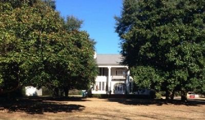
This antebellum plantation house was completed by Capt. William Montgomery, a contemporary of Prattville's founder, Daniel Pratt.
This “Deep South” architecture reflects the Federal style with the later addition of a Colonial . . . — — Map (db m70795) HM
On Maple Street at Pletcher Street, on the right when traveling west on Maple Street.
The plank road was constructed of large pine logs, sawed lengthwise and laid round-side down. Daniel Pratt built the road for public benefit and to provide transportation from the Pratt Cotton Gin Factory to Washington on the Alabama River. Over . . . — — Map (db m27983) HM
On Bridge Street at Gin Shop Hill Road, on the right when traveling west on Bridge Street.
Daniel Pratt, Prattville’s founding father, constructed an imposing home and garden within a quarter-mile of this site on Autauga Creek, near his industrial complex. The large home was designed and erected by Pratt himself, a noted architect / . . . — — Map (db m27985) HM
On Jenkins Farm Road, 0.2 miles east of U.S. 90, on the right when traveling east.
Jenkins Farm
John Wesley Jenkins, born 1874, owned a 40 acre turpentine operation in 1915 when he married Amelia Taylor. With the decline of his turpentine resources, they began growing potatoes. At the time of John Wesley’s death in . . . — — Map (db m155369) HM
On County Road 47, 0.4 miles east of Interstate 65, on the right when traveling east.
"Alabama's First Farm Winery Since Prohibition"
A 50 acre Muscadine Grape Vineyard was established
at this site in 1972 to produce grapes for Bartels
Winery of Pensacola, Florida. In 1979, legislation
sponsored by Rep. John M. McMillan . . . — — Map (db m122470) HM
On Alabama Route 225 just north of Lower Bryants Landing Road, on the left when traveling north.
Here on the banks of the Tensaw River -- named for the Tensa Indian tribe whose principal village was located at this place -- Major Robert Farmar developed a plantation c. 1772. Farmar was one of the most prominent and controversial Alabamians of . . . — — Map (db m66380) HM
On County Road 32, 0.2 miles west of Sherman Road, on the right when traveling west.
Sonora Community
The community of Sonora was named in 1901 by the wife of the first postmaster, G.L. Sharretts. Situated near Red Hill Ford on Baker Branch and the intersection of travel routes between Silverhill, Magnolia Springs, Marlow . . . — — Map (db m130878) HM
Near East Broad Street east of North Livingston Avenue.
A primary factor in the eventual expulsion of the Creeks from their ancestral homeland was the fact that their territory was some of the best suited in the nation for the production of cotton. Containing enormous tracts of productive soils, a long . . . — — Map (db m101658) HM
On North Eufaula Avenue (U.S. 431) 0.1 miles north of Broad Street, in the median.
Built by John Hart about 1850, the Hart House is recognized as an outstanding example of pure Greek Revival architecture. Hart (c. 1805-1863) moved from New Hampshire and became a prominent merchant and farmer. When constructed, the house was on the . . . — — Map (db m48376) HM
Near State Park Road south of Furnace Road (County Route 62), on the right when traveling south.
Wilson Hayes constructed this typical farm house for his wife and six children just south of Six Mile around 1900. After he moved to Oklahoma c. 1915, his daughter Ollie and her husband Levert Rotenberry lived in the home until 1928. Between 1928 . . . — — Map (db m37136) HM
On Pelham Road (State Highway 21) at 5th Street NE, on the right when traveling north on Pelham Road.
Prominent citizen of Jacksonville who served Alabama as Brigadier General, State Militia; member Legislature and Pres. of Senate; Circuit Court Judge; and Pres. Ala. and Tenn. Railroad
He owned extensive cotton plantations and mining interests . . . — — Map (db m29921) HM
The Mississippian inhabitants of Choccolocco were skilled
agriculturalists who grew corn, squash and beans in addition to
the many wild plants that they harvested. Archaeologists
working here have found the remains of many of these plants in
the . . . — — Map (db m144950) HM
On U.S. Highway 84 (U.S. 84) 1.9 miles west of Lena Landegger Highway (County Road 39), on the right when traveling west.
This 4000 acre complex has been recognized for its contribution to our understanding of the history of Monroe County and the State of Alabama. Originally developed as a cotton plantation during the Antebellum period, this farm has been in continuous . . . — — Map (db m80345) HM
On College Avenue (Alabama Route 177) at West Clinton Street, on the right when traveling south on College Avenue.
On this site was located the First District Agricultural College, authorized by an act of the Alabama Legislature and opened in 1896. The street in front was changed from Grove Hill Road to College Avenue in honor of the new school. An Experimental . . . — — Map (db m101603) HM
On Court Square at 1st Street North, on the right when traveling west on Court Square.
Side 1
Clay County was formed by an act of the Alabama General Assembly on December 7, 1866. Less than a year later, Ashland was established as the county seat on land donated by Hollingsworth Watts for the construction of a . . . — — Map (db m95087) HM
On Main Street (U.S. 84) at College Street, on the right when traveling north on Main Street.
In profound appreciation of the Boll Weevil and what it has done as the Herald of Prosperity this monument was erected by the Citizens of Enterprise, Coffee County, Alabama — — Map (db m30306) HM
Near Natchez Trace Parkway (at milepost 327.3), 1.4 miles east of N Pike (County Route 21), on the left when traveling east.
During the early 1800s, a slave-owning planter class including George Colbert’s family, emerged among the Chickasaw.
George’s success stemmed from a variety of endeavors. He fought with the Americans against the Shawnee and Creeks, traveled to . . . — — Map (db m107261) HM
On Lime Kiln Road at Houston Street, on the right when traveling north on Lime Kiln Road.
The Clyde Carter House, built in 1924,
was listed on the
National Register of
Historic Places, 2004
Criterion C in the area of Architecture
Criterion A in the area of Agriculture — — Map (db m192041) HM
Built between 1828 and 1832, Belle Mont is a foremost example of Jeffersonian Palladian Architecture in the deep south and one of Alabama's first great plantation houses.
It was build for Dr. Alexander W. Mitchell, a native of Virginia, and a . . . — — Map (db m29561) HM
On 2nd Avenue NE south of Young Street NE, on the right when traveling south.
In 1946, the McPhillips family brought King Pharr Canning Company, a major vegetable canning operation to Cullman. Led by chairman Julian B. McPhillips of Mobile, and his two sons Julian L. McPhillips and W. Warren McPhillips (returning from Navy . . . — — Map (db m101093) HM
Land-based activities affect water quality and quantity. For that reason, it is important that we make good decisions about our day to day actions.
Dry stacks prevent poultry manure from entering streams.
Silt fences prevent erosion from . . . — — Map (db m107957) HM
Thrifty German colonists, led by Col. John G. Cullman, in 1873 settled this thinly populated plateau.
This section, previously thought unproductive, became famous for its diversified crops. — — Map (db m29976) HM
On New Hope Road (County Road 1809) 0.2 miles south of County Road 1816, on the right when traveling south.
Thomas Monroe Corbin and his wife, Ella, settled here in 1894 on 80 acres and built a home. As pioneers, they cleared the ground with crosscut saws, draft horses, double-bit axes, and shovels. Rocks from the field, removed with a horse-drawn slide, . . . — — Map (db m160656) HM
On Capitol Street at Cahaba Road, on the right when traveling east on Capitol Street. Reported permanently removed.
Waist-high grasses billowing in the
wind. Rolling prairie expanses. Most
people connect these images with the Midwest's Great Plains. But for
thousands of years, tallgrass
soils of Alabama's Black Belt. Along
prairie—25 miles across at its . . . — — Map (db m112692) HM
On Capitol Avenue at Cahaba Road, on the right when traveling east on Capitol Avenue.
Alabama's Black Belt region derives
its name from a narrow sash of
dark, fertile soil across the state's
midsection. Covering 1000 square
miles, the Black Belt occupies just 2%
of the state's landmass, but its history
and transformations . . . — — Map (db m112800) HM
On 6th South Street. Reported permanently removed.
This artesian well was drilled to serve a factory which did not materialize. It was then used to water the grounds, a garden and pastures. In addition, by forcing water through pipes into his $50,000 home, E. M. Perine, a merchant prince, had the . . . — — Map (db m83518) HM
On Oak Street near 2nd Street North, on the left when traveling north. Reported permanently removed.
In 1889, Samuel and Sarah Kirkpatrick moved to Selma, leaving their farm and house in the capable hands of their son Clifton (1863-1930). He turned the abandoned remains of Alabama's first capital into a showcase farm of diversified, scientific . . . — — Map (db m23005) HM
On Oak Street north of Fifth North Street, on the left when traveling north.
Look around you. There are hundreds
of pecan trees growing nearby. All were
planted by Clifton Kirkpatrick, a.k.a.
The Duke of Cahaba." (Note: Cahawba
lost its "w" by the late 19th century.)
In 1889 Samuel and Sarah Kirkpatrick . . . — — Map (db m112473) HM
On County Road 117, 0.1 miles east of County Road 20, on the right when traveling east.
In 1800, Thomas Reeves purchased 150 acres of land in this area and then passed it to his daughter, Elizabeth Reeves Hales in 1836. Rev. William Stith and Elizabeth Davie Hardy came to the West Greene community in 1879, where they bought a farm and . . . — — Map (db m203612) HM
On County Route 47, 0.4 miles north of County Route 177, on the left when traveling north.
(side 1)
Captain Dennis Harrison Zorn
Dennis Harrison Zorn was born in 1843 at Lodi, Barbour County, Alabama. At the outbreak of the Civil War, he entered the service in the 15th Alabama Infantry. He lost an arm at Cold Harbor in . . . — — Map (db m176019) HM
On Main Street, 0.1 miles south of Alabama Route 173, on the right when traveling north.
Begun on 160 acres of land owned by Dr. Joshua Head, "Head's Land," or Headland, was established in 1871, incorporated as a town in 1884 and a city in 1893. The land itself yielded the city's first industry. Due to the abundance of pine trees, . . . — — Map (db m71816) HM
Near Alabama Route 605 at Hosea Road, on the right when traveling north.
Taylor, one of the area's oldest communities, became a small town
around 1870. Billy Taylor, son of James and Wealthy Taylor,
established the post office and was appointed the first postmaster.
Thus Taylor derived its name from the first . . . — — Map (db m179475) HM
On County Road 25 at County Road 107, on the right when traveling north on County Road 25.
History excerpted from various articles written
by Dr. David Campbell, president of
Northeast Alabama State Community College
Skyline Farms was an effort to build a “new world” in rural America where tenant farmers, hit hard by . . . — — Map (db m167093) HM
Near 12th Avenue at Cahaba Street, on the left when traveling east.
Marker Front:
Founded in 1886 on 600 acres of land, East Birmingham was the agricultural area consisting primarily of dairy farms extending to the present Birmingham airport. The East Birmingham Land Company that developed the area was . . . — — Map (db m83827) HM
On Park Avenue at Chapel Road, on the left when traveling south on Park Avenue.
This house was provided for the overseer of the 560-acre A. B. Howell Peach Orchard. William Morgan and William and Evan Hale were overseers. The house was purchased by John and Marie Taylor in 1989 and was placed on the Alabama Register of . . . — — Map (db m28494) HM
On Montevallo Road (Alabama Route 119) near Woodruff Parkway, on the left when traveling east.
Thomas Rowan, son of Irish immigrants who settled in St. Clair County, Alabama, purchased his first 130 acres at auction and built a house here by c. 1854 that probably forms the core of the two northeast rooms. Heir John Thomas Rowan and his wife, . . . — — Map (db m24716) HM
Near Tannehill Road, 0.5 miles north of Confederate Parkway, on the right when traveling north.
1. Gear House
2. Smoke House
3. Corn Crib
4. Double Pole Barn
Donated by Mr. & Mrs. Carthell Kornegay. These buildings were located on the
George Stewart Farm in Bibb County and restored in 1975… — — Map (db m107513) HM
On Tannehill Road, 0.5 miles north of Confederate Parkway, on the right when traveling north.
James Monroe "Jim" Williams married Martha Evaline George.
Mr. Williams was a farmer and a coal miner at Gray Hill in Bibb County, Alabama.
They raised ten children, of which seven were born in this house.
Donated by Mrs. Audry . . . — — Map (db m107511) HM
On Mountain Brook Parkway east of Old Mill Lane, on the left when traveling east.
Robert Jemison, Jr. (1878-1974)
The Father of Mountain Brook
A man of great vision, dreams and enthusiasm, Robert Jemison, Jr. was by far the greatest real estate developer of Birmingham’s 20th century. The Post-Herald newspaper . . . — — Map (db m83922) HM
On East Main Street (U.S. 278) at Bankhead Street, on the right when traveling east on East Main Street.
Farmer Confederate Soldier Legislator
Member U.S. House and Senate
Thirty Three Years
Father of Federal Aid to Good Roads
Author making Warrior
longest canalized river in the world
Active in
development of Muscle Shoals and other . . . — — Map (db m96473) HM
This park was donated to the people of Florence by Dr. Kirk R. and Lillian Cook Deibert who initially acquired this property in 1952. The acreage was once a part of a large ante-bellum plantation owned by Judge Sidney Cherry Posey. In 1875 his heirs . . . — — Map (db m33086) HM
Near Hightower Place, 0.3 miles south of Veterans Drive.
Named President of the International Fertilizer Development Center in 1992, Dr. Amit Roy distinguished himself as a leader of a team to create sustainable agricultural productivity worldwide, alleviating hunger and ensuring food security. . . . — — Map (db m219337) HM
Near Hightower Place south of Veterans Drive (Alabama Route 133), on the left when traveling south.
Serving 16 years as president of the American Farm Bureau Federation (1931-1947), Mr. O'Neal developed major New Deal farm policies in the Franklin D. Roosevelt Administration. — — Map (db m219327) HM
Near Hightower Place south of Veterans Drive (Alabama Route 133), on the left when traveling south.
In 1947 Frank Achorn began his successful work as a chemical engineer in 45 states and 40 countries to feed the hungry of the world through increased crop yields. He later secured eight patents related to the fertilizer industry. — — Map (db m219177) HM
Near Hightower Place south of Veterans Drive (Alabama Route 133), on the left when traveling south.
For 21 years following the end of World War II, John Bulls served as Agricultural Extension Advisor for the U.S. State Dept. in India, Nigeria, Tunisia and Uganda, assisting farmers and organizing community development programs. — — Map (db m219298) HM
On McFarland Park Road, on the right when traveling west.
This bottom land serves as a reservoir for TVA's flood control program.
Florence leases it for recreational purposes when not being used by TVA.
Major Robert McFarland, a native of Ireland, his wife, Kate Armstead McFarland, and their seven . . . — — Map (db m28453) HM
Near South Court Street at Canal Street, on the right when traveling south.
The American government wanted the Chickasaw land to grow cotton. The Chickasaw began negotation with the United States government in 1786 and within 50 years their ancestral homeland and hunting grounds were cederd to the American government. As . . . — — Map (db m212216) HM
Side A
In 1818 three Wilson brothers John, Matthew and Samuel, came from Virginia to purchase large farms in this area. The plantations of John and Matthew joined near this cemetery. All three brothers and their families are buried here. . . . — — Map (db m28160) HM
On Alabama Street south of Tennessee Street, on the right when traveling south.
A combination of rich soil, mild climate and ready access to market via river and later railroad made Courtland an early center of cotton production. From surrounding plantations with colorful names like Bonnie Doone, Oak Grove, Rocky Hill, . . . — — Map (db m71285) HM
Side A Federal lands in this area were first sold in 1818 and quickly purchased by settlers and speculators. A group of investors calling themselves the “Courtland Land Company” and consisting of William H. Whitaker, James M. . . . — — Map (db m28989) HM
On Donahue Drive, 0.3 miles south of West Samford Drive, on the right when traveling south.
On January 31, 1921, farmers gathered on the campus of Alabama
Polytechnic Institute (API), now Auburn University, to form the
Alabama Farm Bureau, now known as the Alabama Farmers Federation.
Former Alabama Extension Service Director Luther . . . — — Map (db m194773) HM
On Shelton Mill Road (County Route 97) 0.8 miles north of East University Drive, on the left when traveling north.
Marker Front:
The Greek Revival rock and mortar house was built by Addison Frazer (1809-1873) between 1852 and 1854 and served as the center for a 2,000 acre cotton plantation. Frazer owned 100 slaves and was on the Board of Trustees of . . . — — Map (db m25988) HM
Near Woodfield Drive, 0.1 miles east of South College Street (Alabama Route 15), on the right when traveling east.
The Cullars Rotation
(Established 1911)
The Cullars Rotation is the oldest, continuous soil fertility study in the South and the second oldest cotton study in the world. It was started in 1911 by the Alabama Agricultural . . . — — Map (db m74463) HM
On Lem Morrison Drive, 0.1 miles north of Duncan Drive, on the right when traveling north.
Established in 1896 by Professor J.F. Duggar, the Old Rotation at Auburn University is: (1) the oldest, continuous cotton experiment in the U.S.; and (2) the 3rd oldest continuous field crop experiment in the U.S.; and (3) the 1st experiment to . . . — — Map (db m74429) HM
Near Park Road, 0.1 miles west of Rocky Brook Road, on the right when traveling west.
This "Top Rock" Millstone
was in a grist mill
owned and operated by W.S.A. Bence
on Sweetwater Creek in Clay County, AL
1919-1947
Donated by H.S. Bence — — Map (db m75160) HM
On South Jefferson Street near West Washington Street, on the right when traveling north.
A section of the fence that surrounded the 'Court House' grounds until 1916. When construction of the present building was planned, the fence was moved to the County Poor Farm on Elkton Rd. This section donated to the people of Limestone County by . . . — — Map (db m85390) HM
On North Jefferson Street north of West Washington Street, on the right when traveling north.
On June 22, 1933, Judge James Horton of Athens set aside the verdict and death sentence of an all-white jury that found Haywood Patterson, an African American, guilty of raping two white women. Patterson was one of nine black youths falsely accused . . . — — Map (db m154195) HM
Near Oakwood Lane at Old Highway 20, on the left when traveling south.
VA native John Nelson Spotswood Jones, son of Rev. War Capt. Lewellen Jones, cousin of Martha Washington, and descendant of Rev. Rowland Jones of Williamsburg's Bruton Parish, built Druid's Grove near this site before 1820 and established the . . . — — Map (db m70235) HM
On Old Highway 20 at Mooresville Road on Old Highway 20.
Front The town of Cottonport flourished in the early years of Limestone County. It was settled in 1818 and chartered in 1824. It was located approx. 1½ miles S.E. near the point where Limestone Creek flowed into the Tennessee River and . . . — — Map (db m85455) HM
On Huntsville Browns Ferry Road (County Route 24) 0.2 miles west of Cambridge Lane (County Route 93), on the right when traveling west.
A grand two story brick house built in the Federal style with a double tier pedimented Palladian portico. The house displays architectural features brought to Limestone County by early settlers from Southside Virginia, and adjacent North . . . — — Map (db m90915) HM
On Huntsville Browns-Ferry Road (County Route 24) 0.7 miles east of Interstate 65, on the left when traveling east.
One of the oldest brick houses in the country. It was built, circa 1822-28, by Wm. Parham for Joseph Johnston, the original landowner. It displays both Georgian and Federal influences in its style and details. A molded brick water table and . . . — — Map (db m117805) HM
On Auburn Street (U.S. 80) at Tysonville Road (County Highway 97), on the left when traveling north on Auburn Street.
(obverse)
Beginning in the mid-1930s during the Great Depression, the federal New Deal promoted Land Resettlement to move farmers across the nation off worn out soil to new farmland. The Resettlement Administration, and its successor the . . . — — Map (db m68000) HM
On University Avenue at North Water Street, on the right when traveling west on University Avenue.
The primary idea in all of my work was to help the farmer and fill the poor man's empty dinner pail . . .
—George Washington Carver
George Washington Carver taught classes and developed new products from peanuts, . . . — — Map (db m101938) HM
A life that stood out as a gospel of self-forgetting service. He could have added fortune to fame but caring for neither he found happiness and honor in being helpful to the world.
The centre of his world was the South where he was born in . . . — — Map (db m100165) HM
. . . I always make it a rule to read a chapter [in the Bible] or a portion of a chapter in the morning, before beginning the work of the day.
—Booker T. Washington, Up From Slavery
The chapel, designed by Paul . . . — — Map (db m100162) HM
On Panorama Drive Southeast at Skyview Drive Southeast, on the right when traveling east on Panorama Drive Southeast.
Caroline (Cherokee) & William (Scotch-Irish) Schrimsher first of four generations to farm this 36 acres from 1880-1939. After World War II Wernher von Braun's team of scientists were brought from Germany to Ft. Bliss, Texas and then to Huntsville, . . . — — Map (db m154271) HM
Near Church Street Southwest south of Clinton Avenue West, on the left when traveling south.
Roughly 7-20 million gallons of water emerge from The Big Spring every day. Even in the 19th and 20th centuries, when people used the spring as their main water supply, most of the water generated by The Big Spring flowed down the Indian Creek Canal . . . — — Map (db m167111) HM
On Beth Road just west of New Market Road (County Road 100), on the right when traveling east.
For 53 years Madison County operated an establishment one-half mile to the south where the indigent, lame, and unfortunate were housed in a series of log buildings. Each year a superintendent and a physician were appointed to care for their needs. . . . — — Map (db m154290) HM
On Winchester Road near New Market Road, on the left when traveling south.
Settled by Pioneers early as 1806. Voting Precinct established 1827. Town incorporated 1837.
George Smith, major landowner of town site, built first log house and established mercantile business, 1814. John Miller excavated millrace, erected . . . — — Map (db m31657) HM
On 6th Street at Record Street, on the right when traveling east on 6th Street.
Originally called “The Prairie” by the Chickasaw Indians who settled here, Triana was incorporated November 13, 1819 as the second town in Madison County. The community purportedly was named after Rodrigo de Triana, the crewman who first . . . — — Map (db m70237) HM
On South Cedar Avenue at East Whitfield Street, on the right when traveling north on South Cedar Avenue.
Built 1842-1860 by Gen. Nathan Bryan Whitfield 1799-1868 accomplished planter of the Canebrake
using imported materials and artisans Glorifying the Greek Revival Architecture by combining Doric exterior
Corinthian grand ballroom Ionic parlor . . . — — Map (db m38068) HM
On Cullman Road (Alabama Route 69) at Main Street (Alabama Route 69), on the right when traveling west on Cullman Road.
The Farmer’s Exchange was a focal point of commerce during the early years of the young town of Arab. Farmers exchanged their corn, eggs, butter, hides and other agricultural products for a barrel of flour, a stand of lard or other . . . — — Map (db m40627) HM
On S Main Street (Alabama Route 205) at Mill Ave (Alabama Highway 168), on the right when traveling north on S Main Street.
Side A Informally called Sparkstown for a period of time, the city of Boaz was officially named after the husband of Ruth, a Biblical character in the Old Testament. Incorporated in March 1897, Boaz quickly began to "set a pace for her . . . — — Map (db m39156) HM
On North Joachim Street, 0.1 miles south of Congress Street.
One of the premier antebellum structures in the city, the house was built by Charles Richards, a riverboat captain originally from Maine. The building is considered to have Mobile's finest cast iron, featuring figures in a garden setting and . . . — — Map (db m241961) HM
On Lincoln Road, 0.1 miles north of Harrison Road, on the right when traveling north.
Ben F. Moore was born enslaved in Alabama in 1848 to Muddy and Hannah Moore. In 1873, he married Mittie Spencer (1852-19??). The couple had fourteen children, six of whom survived to adulthood. Moore was a tenant farmer turned carpenter and lived on . . . — — Map (db m205230) HM
Near Dexter Avenue at North Bainbridge Street, on the right when traveling west.
Cotton State
Alabama's rapid growth depended on cotton cultivation.
Statehood coincided with improvement of the cotton gin and
increased demand for cotton in British and northern factories.
Within thirty years, Alabama was producing 23 . . . — — Map (db m182595) HM
On Dexter Avenue east of South Decatur Street, on the right when traveling east.
Populism
Through the 1870s and 1880s, depressed cotton prices
brought suffering and hardship for hundreds of thousands
of farm families, black and white. In the 1890s, a coalition
of small farmers and industrial laborers challenged . . . — — Map (db m182616) HM
On Dexter Avenue east of Decatur Street when traveling east.
Rural Life
Despite the growth of cities and industry, until the 1940s
most Alabamians lived on farms. In an economy where cotton
was still king, merchants would extend credit only for that
crop, leading to overproduction and low prices. . . . — — Map (db m182622) HM
On Hyundai Boulevard (County Route 42) at Mobile Highway (U.S. 31), on the right when traveling east on Hyundai Boulevard.
This 2.8-mile road connecting U.S. highways 331 and 31 first appeared on Montgomery County road maps in 1928. Land for the road was deeded to Montgomery County in September 1926 by local landowners from the Teague, Bellingrath and Matthews families. . . . — — Map (db m70932) HM
On Hyundai Boulevard (County Road 42) west of Norman Bridge Road (U.S. 331), on the right when traveling west.
This 2.8-mile road connecting U.S. highways 331 and 31 first appeared on Montgomery County road maps in 1928. Land for the road was deeded to Montgomery County in September 1926 by local landowners from the Teague, Bellingrath and Matthews families. . . . — — Map (db m99235) HM
On Federal Road (County Route 24) 0.1 miles west of Mobile Highway (U.S. 31), on the left when traveling west.
(Side 1)
Pintlala Grange Hall
The National Grange of the Patrons of Husbandry was organized in 1867 to provide economic, social and cultural improvements for farmers and their families. Pintlala's Grange Hall was erected circa . . . — — Map (db m71433) HM
On 8th Street at Prospect Drive, on the right when traveling north on 8th Street.
"The opportunies which were at hand in the development of the river and the region were being seized upon by our people with renewed courage and confidence.
We now know that we couldn't be licked again, that what had been preached to us by TVA was . . . — — Map (db m86505) HM
On South Main Street (Alabama Route 93) 0.1 miles south of SA Graham Boulevard (Alabama Route 10), on the right when traveling south.
Side 1
City of Brundidge and the Bass House
Brundidge was founded in 1851 and incorporated in 1890. Brundidge City Hall has been located in the former Bass House on South Main Street in downtown Brundidge since November 1992. . . . — — Map (db m71796) HM
On Lockheed Martin Drive (County Route 37) at Old U.S. Highway 231 (County Route 105), on the left when traveling east on Lockheed Martin Drive.
Founded 1848 by legislative act and donations of citizens. Excellent instruction made it only school of kind for youth in area. Later used as public school until 1929 school consolidation.
Orion settled about 1815, by 1830 saw arrival of . . . — — Map (db m71791) HM
On Church Road at Railroad Street (County Route 20), on the right when traveling south on Church Road.
Nimrod Washington Long moved to Alabama from Georgia in the 1830s. A planter, mill owner and state legislator, he had real estate and railroad interests in Russell County. This house was the plantation home of Nimrod Washington Long in Spring Hill, . . . — — Map (db m69433) HM
On Dillingham Street at Brickyard Road (Route 61) on Dillingham Street.
During the tumultuous decades prior to the Removal of the Creeks from their ancestral homelands in the 1830s, the vicinity of the town of Coweta became an important location for interaction between the Creek Nation and the American government. . . . — — Map (db m101339) HM
On Salem Road (County Road 15) 1.2 miles north of State Route 119, on the left when traveling north.
The home of Washington H. McGaughy and
his wife Nancy Prentice Wynn,
the original dogtrot homestead built by
the Perry family. The 120-acre farm was
formerly part of the Perry Plantation. After
Perry Hall was completed in 1836, this . . . — — Map (db m159576) HM
On North Norton Avenue at West 4th Street, on the left when traveling north on North Norton Avenue.
Founded in 1896 by brothers John Judge and Milton Graham Hightower, this small-town livery stable served the community and surrounding countryside until its closing in 1955. Originally located nearby, the business moved to this “New . . . — — Map (db m57763) HM
On South Broadnax Street at Eufalla Street, on the right when traveling south on South Broadnax Street.
Fletcher Farrington, after graduating from the Alabama Polytechnic Institute (now Auburn University), came to Tallapoosa County as a county agent for the Agricultural Extension Service in 1932. Concluding that soil erosion was the local farmers . . . — — Map (db m95105) HM
He oversaw the closing of the unstable State Bank. In 1845 the legislature amended the constitution to allow the removal of the capital from Tuscaloosa. The growing wealth and population of the Black Belt brought the seat of government to Montgomery. — — Map (db m29033) HM
On East Central Avenue, 0 miles east of Main Street, on the right when traveling east.
Built in the early 1900s by one of Eagar's prominent civic, religious & business leaders, this barn was constructed with wooden pegs & retains remarkable architectural integrity. The 2-story brick farmhouse no longer stands. — — Map (db m36640) HM
On South River Road, 0.3 miles south of West 4th Avenue, on the right when traveling west.
Just west on the river, W.R Milligan built the first grist mill & sawmill in Round Valley, later a brick kiln was added. Subsequent owners included the Udall Bros. & J.P. Rothlisberger who built the barn just ahead. — — Map (db m158475) HM
On North Gemini Drive, on the right when traveling north.
From 1857-60, Lt. Edward F. Beale and a crew of 100 men completed the first federal highway in the southwest from Fort Smith, Ark. to Los Angeles, Calif. at a cost of $200,000. The wagon road was used extensively by immigrants en route to California . . . — — Map (db m33346) HM
On South Milton Road (Business Interstate 40) at West Tucson Avenue, on the right when traveling north on South Milton Road. Reported missing.
This 1945 Model H International Farmall, purchased by the Zanzucchi Family after World War II, was used to plow the "Fields" at the Flagstaff Dairy. The Flagstaff Dairy operated from 1904 thru 1979 and was located 3 miles west of Flagstaff on Old . . . — — Map (db m178779) HM
Behind you is the Bright Angel mule corral, where each morning mules greet riders and another adventure begins. Mules have carried people into Grand Canyon since sightseeers first visited here in the 1890s. For many people - including those who . . . — — Map (db m205170) HM
Near Arizona Route 67, 1.2 miles south of U.S. 89A, on the left when traveling south.
This location has two markers
This steel lookout tower is 80 feet tall and has a 7 foot by 7 foot steel cab on top. It was erected in 1934.
As guardians of our nation's vast timber reserves, the U.S. Forest Service has always given fire . . . — — Map (db m94919) HM
On Mormon Lake Road (Route 90 at milepost 4), 3.9 miles south of Lake Mary Road (Route 3), on the right when traveling south.
Between 1876 and 1886, Hyrum Judd, under the direction of Lot Smith, supervised a Mormon Dairy one
mile northeast near Dairy Spring.
Beginning with a herd of 115 cows, large quantities of butter and cheese were produced. During the 1880s the . . . — — Map (db m35187) HM
Near Grand Canyon Highway (Arizona Route 67) 43 miles south of U.S. 89A.
Built more than 900 years before the Grand Canyon Lodge, the foundations of this small, two-room dwelling provide a glimpse of the kinds of lodging used by ancestral Puebloan farmers of the North Rim. These native farmers built field houses like . . . — — Map (db m163577) HM
6661 entries matched your criteria. The first 100 are listed above. Next 100 ⊳