By Mark Hilton, December 17, 2013
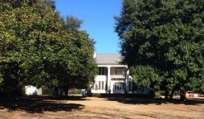
Buena Vista Plantation Home
| On County Road 4 0.1 miles west of Buena Vista Boulevard, on the right when traveling west. |
| On Maple Street at Pletcher Street, on the right when traveling west on Maple Street. |
| On Bridge Street at Gin Shop Hill Road, on the right when traveling west on Bridge Street. |
| On County Road 22 0.3 miles east of County Road 130, on the left when traveling north. |
| On Main Street south of U.S. 89. |
| On South Bancroft Street, on the left when traveling south on South Bancroft Street. |
| On Jenkins Farm Road 0.2 miles east of U.S. 90, on the right when traveling east. |
| On County Road 47 0.4 miles east of Interstate 65, on the right when traveling east. |
| On Alabama Route 225 just north of Lower Bryants Landing Road, on the left when traveling north. |
| On County Road 32 0.2 miles west of Sherman Road, on the right when traveling west. |
| Near East Broad Street east of North Livingston Avenue. |
| On North Eufaula Avenue (U.S. 431) 0.1 miles north of Broad Street, in the median. |
| Near State Park Road south of Furnace Road (County Route 62), on the right when traveling south. |
| On Pelham Road (State Highway 21) at 5th Street NE, on the right when traveling north on Pelham Road. |
| On U.S. Highway 84 (U.S. 84) 1.9 miles west of Lena Landegger Highway (County Road 39), on the right when traveling west. |
| On College Avenue (Alabama Route 177) at West Clinton Street, on the right when traveling south on College Avenue. |
| On Court Square at 1st Street North, on the right when traveling west on Court Square. |
| On Main Street (U.S. 84) at College Street, on the right when traveling north on Main Street. |
| Near Natchez Trace Parkway (at milepost 327.3), 1.4 miles east of N Pike (County Route 21), on the left when traveling east. |
| On Lime Kiln Road at Houston Street, on the right when traveling north on Lime Kiln Road. |
| On Nymph Road (County Route 85) at Hickory Tree Road, on the left when traveling south on Nymph Road. |
| On 2nd Avenue NE south of Young Street NE, on the right when traveling south. Reported missing. |
| On New Hope Road (County Road 1809) 0.2 miles south of County Road 1816, on the right when traveling south. |
| Near New Hope Road (County Road 71/1809) north of County Road 1811, on the right when traveling north. |
| On Capitol Street at Cahaba Road, on the right when traveling east on Capitol Street. Reported permanently removed. |
| On Capitol Avenue at Cahaba Road, on the right when traveling east on Capitol Avenue. |
| On 6th South Street. Reported permanently removed. |
| On Oak Street near 2nd Street North, on the left when traveling north. Reported permanently removed. |
| On Oak Street north of Fifth North Street, on the left when traveling north. |
| On County Road 117 0.1 miles east of County Road 20, on the right when traveling east. |
| On County Route 47 0.4 miles north of County Route 177, on the left when traveling north. |
| On Main Street 0.1 miles south of Route 173, on the right when traveling north. |
| Near Alabama Route 605 at Hosea Road, on the right when traveling north. |
| On County Route 21 1 mile east of Route 79, on the right when traveling east. |
| On County Road 25 at County Road 107, on the right when traveling north on County Road 25. |
| Near 12th Avenue North at Cahaba Street, on the left when traveling east. |
| On Park Avenue at Chapel Road, on the left when traveling south on Park Avenue. |
| On Montevallo Road Southwest (Alabama Route 119). |
| On Montevallo Road (Alabama Route 119) near Woodruff Parkway, on the left when traveling east. |
| Near Tannehill Road 0.5 miles north of Confederate Parkway, on the right when traveling north. |
| On Tannehill Road 0.5 miles north of Confederate Parkway, on the right when traveling north. |
| On Mountain Brook Parkway east of Old Mill Lane, on the left when traveling east. |
| On East Main Street (U.S. 278) at Bankhead Street, on the right when traveling east on East Main Street. |
| On Hightower Place near Darby Drive. |
| Near Hightower Place 0.3 miles south of Veterans Drive. |
| Near Hightower Place south of Veterans Drive ( Route 133), on the left when traveling south. |
| Near Hightower Place south of Veterans Drive ( Route 133), on the left when traveling south. |
| Near Hightower Place south of Veterans Drive ( Route 133), on the left when traveling south. |
| On McFarland Park Road, on the right when traveling west. |
| Near South Court Street at Canal Street, on the right when traveling south. |
| On Plantation Springs Drive. |
| On Alabama Street south of Tennessee Street, on the right when traveling south. |
| On Donahue Drive 0.3 miles south of West Samford Drive, on the right when traveling south. |
| On Shelton Mill Road (County Route 97) 0.8 miles north of East University Drive, on the left when traveling north. |
| Near Woodfield Drive 0.1 miles east of South College Street ( Route 15), on the right when traveling east. |
| On Lem Morrison Drive 0.1 miles north of Duncan Drive, on the right when traveling north. |
| Near Park Road 0.1 miles west of Rocky Brook Road, on the right when traveling west. |
| On South Jefferson Street near West Washington Street, on the right when traveling north. |
| On North Jefferson Street north of West Washington Street, on the right when traveling north. |
| Near Oakwood Lane at Old Highway 20, on the left when traveling south. |
| On High Street south of North Street Southeast, on the right when traveling north. |
| On Huntsville Browns Ferry Road (County Route 24) 0.2 miles west of Cambridge Lane (County Route 93), on the right when traveling west. |
| On Huntsville Browns-Ferry Road (County Route 24) 0.7 miles east of Interstate 65, on the left when traveling east. |
| On Auburn Street (U.S. 80) at Tysonville Road (County Highway 97), on the left when traveling north on Auburn Street. |
| On University Avenue at North Water Street, on the right when traveling west on University Avenue. |
| Near Booker T Washington Boulevard. |
| On Foster Drive at Moton Drive, on the right when traveling south on Foster Drive. |
| On Booker T Washington Boulevard. |
| On Panorama Drive Southeast at Skyview Drive Southeast, on the right when traveling east on Panorama Drive Southeast. |
| Near Church Street Southwest south of Clinton Avenue West, on the left when traveling south. |
| On Beth Road just west of New Market Road (County Road 100), on the right when traveling east. |
| On Winchester Road near New Market Road, on the left when traveling south. |
| On 6th Street at Record Street, on the right when traveling east on 6th Street. |
| On South Cedar Avenue at East Whitfield Street, on the right when traveling north on South Cedar Avenue. |
| On Cullman Road (Alabama Route 69) at Main Street ( Route 69), on the right when traveling west on Cullman Road. |
| On S Main Street (Alabama Route 205) at Mill Ave ( Highway 168), on the right when traveling north on S Main Street. |
| On North Joachim Street 0.1 miles south of Congress Street. |
| On Lincoln Road 0.1 miles north of Harrison Road, on the right when traveling north. |
| Near Dexter Avenue at North Bainbridge Street, on the right when traveling west. |
| On Dexter Avenue east of South Decatur Street, on the right when traveling east. |
| On Dexter Avenue east of Decatur Street when traveling east. |
| On Hyundai Boulevard (County Route 42) at Mobile Highway (U.S. 31), on the right when traveling east on Hyundai Boulevard. |
| On Hyundai Boulevard (County Road 42) west of Norman Bridge Road (U.S. 331), on the right when traveling west. |
| On Federal Road (County Route 24) 0.1 miles west of Mobile Highway (U.S. 31), on the left when traveling west. |
| On 8th Street at Prospect Drive, on the right when traveling north on 8th Street. |
| On Indian Hills Road Southeast at West View, on the right when traveling south on Indian Hills Road Southeast. |
| On South Main Street (Alabama Route 93) 0.1 miles south of SA Graham Boulevard ( Route 10), on the right when traveling south. |
| On Lockheed Martin Drive (County Route 37) at Old U.S. Highway 231 (County Route 105), on the left when traveling east on Lockheed Martin Drive. |
| Near Alabama 165 (Alabama Route 165) 2.3 miles south of Nuckols Road. |
| On Church Road at Railroad Street (County Route 20), on the right when traveling south on Church Road. |
| On Dillingham Street at Brickyard Road (Route 61) on Dillingham Street. |
| On Salem Road (County Road 15) 1.2 miles north of State Route 119, on the left when traveling north. |
| On North Norton Avenue at West 4th Street, on the left when traveling north on North Norton Avenue. |
| On South Broadnax Street at Eufalla Street, on the right when traveling south on South Broadnax Street. |
8488 entries matched your criteria. The first 100 are listed above.
Next 100 ⊳
