3764 entries match your criteria. Entries 301 through 400 are listed.⊲ Previous 100 — Next 100 ⊳
Bridges & Viaducts Topic
By Mike Stroud, May 30, 1994
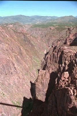
Royal Gorge
| 301 ► Colorado, Fremont County, Cañon City — 141 — Royal Gorge — |
| On County Road 3A 4.5 miles south of U.S. 24, on the right when traveling south. | |||
| 302 ► Colorado, Fremont County, Cañon City — Royal Gorge Bridge — |
| On County Road 3A, on the left when traveling east. | |||
| 303 ► Colorado, Fremont County, Florence — Rio Grande Railroad Viaduct — |
| On Colorado Route 120 south of Route 115, on the right when traveling south. | |||
| 304 ► Colorado, Fremont County, Penrose — Arkansas Valley Country — |
| On U.S. 50 0.2 miles east of Phantom Canyon Road (County Road 67), on the right when traveling west. | |||
| 305 ► Colorado, Fremont County, Penrose — The Royal Gorge — |
| On U.S. 50 0.2 miles east of Phantom Canyon Road (County Road 67), on the right when traveling west. | |||
| 306 ► Colorado, Gunnison County, Sapinero — Crossing the Canyon — |
| On U.S. 50, on the right when traveling west. | |||
| 307 ► Colorado, Jefferson County, Golden — Billy Drew Bridge |
| Near 10th Street 0 miles south of Illinois Street, on the right when traveling east. Reported permanently removed. | |||
| 308 ► Colorado, Jefferson County, Golden — Bridge Load Ordinance Background — |
| On Washington Avenue. | |||
| 309 ► Colorado, Jefferson County, Golden — Ferrell/Berthoud Home (Miners Hotel) |
| On Washington Avenue. Reported permanently removed. | |||
| 310 ► Colorado, Jefferson County, Golden — Floods on Clear Creek — |
| On Washington Avenue, on the right when traveling south. | |||
| 311 ► Colorado, Jefferson County, Golden — Greeley’s Crossing |
| On Washington Avenue. Reported permanently removed. | |||
| 312 ► Colorado, Jefferson County, Golden — History of the Avenue Bridge — |
| Near Washington Avenue, on the right when traveling south. | |||
| 313 ► Colorado, Jefferson County, Golden — History of the Avenue Bridge 2 — |
| On Washington Street, on the right when traveling north. | |||
| 314 ► Colorado, Jefferson County, Golden — History of the Avenue Bridge 3 — |
| On Washington Street, on the right when traveling south. | |||
| 315 ► Colorado, Jefferson County, Golden — History of the Avenue Bridge 4 — |
| On east side of Washington Street Bridge, on the right when traveling east. | |||
| 316 ► Colorado, Jefferson County, Golden — Horace Greeley’s Crossing Point — |
| Near Washington Avenue. | |||
| 317 ► Colorado, Jefferson County, Golden — Johnson and His Crew — |
| Near Washington Avenue. | |||
| 318 ► Colorado, La Plata County, Durango — Baker's Bridge — |
| On County Highway 250 0.5 miles east of U.S. 550, on the left when traveling east. | |||
| 319 ► Colorado, La Plata County, Durango — Florida River Railroad Bridge No. 437 — |
| On Ranchos Florida Drive 0.2 miles east of County Highway 222, on the right when traveling east. | |||
| 320 ► Colorado, La Plata County, Durango — 10 — Main Avenue Bridge, circa 1908 — |
| Near East 2nd Avenue north of East 15th Street. | |||
| 321 ► Colorado, Montrose County, Cimarron — All Aboard — |
| On Morrow Point Dam Road 1 mile north of U.S. 50, on the left when traveling north. | |||
| 322 ► Colorado, Montrose County, Montrose — Building a Dam — |
| Near East Portal Road. | |||
| 323 ► Colorado, Montrose County, Montrose — Light at the End of the Tunnel — |
| Near East Portal Road. | |||
| 324 ► Colorado, Montrose County, Montrose — The Gunnison Tunnel — |
| On West Main Street at Townsend Avenue, on the right when traveling north on West Main Street. | |||
| 325 ► Colorado, Morgan County, Fort Morgan — Rainbow Arch Bridge — |
| On State Highway 52 0.1 miles north of Interstate 76, on the right when traveling north. | |||
| 326 ► Colorado, Pueblo County, Colorado City — Greenhorn Creek Bridge — The unusual bridge offered a window to travel on one of Colorado's earliest highways — |
| On State Highway 181 south of State Highway 165, on the left. | |||
| 327 ► Connecticut, Capitol Region, Farmington — The Farmington Aqueduct — |
| Near Waterville Road. | |||
| 328 ► Connecticut, Capitol Region, Hartford, Downtown — The Founders Bridge — |
| Near Columbus Boulevard at State Street, on the right when traveling north. | |||
| 329 ► Connecticut, Capitol Region, Simsbury — Weatogue Bridge — |
| Near Old Bridge Road 0.1 miles south of Drake Hill Road. | |||
| 330 ► Connecticut, Lower Connecticut River Valley Region, Clinton — The Hammock Marshes — |
| Near Osprey Commons South east of Beach Park Road, on the right when traveling east. | |||
| 331 ► Connecticut, Lower Connecticut River Valley Region, Colchester — Comstock Covered Bridge — |
| On Colchester Avenue (Connecticut Route 16) at Browns Mill Road, on the right when traveling north on Colchester Avenue. | |||
| 332 ► Connecticut, Lower Connecticut River Valley Region, Old Saybrook — New Raymond E. Baldwin Bridge — |
| On Connecticut Turnpike (Interstate 95) west of Ferry Road, on the right when traveling south. | |||
| 333 ► Connecticut, Lower Connecticut River Valley Region, Old Saybrook — Raymond E. Baldwin Bridge — |
| On Connecticut Turnpike (Interstate 95) west of Ferry Road, on the right when traveling south. | |||
| 334 ► Connecticut, South Central Region, Hamden, Whitneyville — A. Frederick Oberlin Bridge — |
| On Whitney Avenue at Armory Street, on the right when traveling north on Whitney Avenue. | |||
| 335 ► Connecticut, South Central Region, Hamden, Whitneyville — The Town Bridge — |
| Near Whitney Avenue at Armory Street, on the right when traveling north. | |||
| 336 ► Connecticut, South Central Region, Meriden — Red Bridge — |
| On Oregon Road at River Road ( Route 70), on the right when traveling south on Oregon Road. | |||
| 337 ► Connecticut, South Central Region, Milford — Jefferson Bridge — |
| On River Street 0.1 miles north of West River Street, on the left when traveling north. | |||
| 338 ► Connecticut, South Central Region, Milford — King’s Bridge — 1711 — |
| On Maple Street 0.1 miles west of North Street, on the right when traveling west. | |||
| 339 ► Connecticut, South Central Region, Milford — Memorial to Three Milford Men — 1639 1939 — |
| On River Street 0.1 miles north of West River Street, on the right when traveling north. | |||
| 340 ► Connecticut, South Central Region, Milford — Milford Memorial Stone Bridge — |
| On New Haven Avenue (Connecticut Route 162) at Daniel Street, on the left when traveling east on New Haven Avenue. | |||
| 341 ► Connecticut, South Central Region, New Haven, Downtown — Hillhouse Avenue Bridge — |
| On Hillhouse Avenue when traveling north. | |||
| 342 ► Connecticut, South Central Region, New Haven, East Rock — Rock Lane Bridge — |
| On East Rock Road east of Livingston Street, on the left when traveling east. | |||
| 343 ► Connecticut, South Central Region, New Haven, Long Wharf — Pearl Harbor Memorial Bridge — |
| On East Street at Water Street (U.S. 1), on the right when traveling north on East Street. | |||
| 344 ► Connecticut, Southeastern Region, Groton, Mystic — At This Crossing — |
| On West Main Street (U.S. 1) near Gravel Street, on the left when traveling west. | |||
| 345 ► Connecticut, Southeastern Region, Groton, Mystic — Mystic River Bascule Bridge — Built 1922 — Operated by the Connecticut Department of Transportation — |
| On West Main Street (U.S. 1) east of Gravel Street, on the right when traveling east. | |||
| 346 ► Connecticut, Southeastern Region, Norwich, Yantic — Yantic — |
| On Yantic Road, on the right when traveling north. | |||
| 347 ► Connecticut, Southeastern Region, Stonington, Pawcatuck — Pawcatuck Bridge — Westerly, R.I. - Stonington, Conn. — 1932 — |
| On West Broad Street (U.S. 1) east of Coggswell Street, on the right when traveling east. | |||
| 348 ► Connecticut, Southeastern Region, Windham, Willimantic — Thread City Crossing — |
| On Main Street at South Street ( Route 66), on the right when traveling east on Main Street. | |||
| 349 ► Connecticut, Western Region, New Milford — Falls Bridge — |
| Near Still River Drive 0.2 miles east of Pumpkin Hill Road, on the right when traveling east. | |||
| 350 ► Connecticut, Western Region, Newtown — Washington – Rochambeau Revolutionary Route — Housatonic Crossing — |
| On Church Hill Road (U.S. 6) at Queen Street, on the right when traveling west on Church Hill Road. | |||
| 351 ► Connecticut, Western Region, Westport, Westport Village — The Post Road Bridge — |
| On Jesup Road at Taylor Place, on the right when traveling east on Jesup Road. | |||
| 352 ► Delaware, New Castle County, Hockessin — Ashland Bridge — Red Clay Creek — Listed on National Register of Historic Places – 1973 — |
| On Barley Mill Road, on the right when traveling north. | |||
| 353 ► Delaware, New Castle County, New Castle, New Castle Hundred — Delaware Memorial Bridge — 1951 - 1968 — Dedicated to the Delaware & New Jersey Veterans of WWII — |
| Near New Castle Avenue (Delaware Route 9) at Cherry Lane. | |||
| 354 ► Delaware, New Castle County, New Castle, New Castle Hundred — Delaware River and Bay Authority Veterans Dedication — |
| Near Cherry Lane at New Castle Avenue ( Route 9). | |||
| 355 ► Delaware, New Castle County, Newark — The Battle of Cooch's Bridge |
| On Dayett Mills Road south of Old Baltimore Pike, on the right when traveling south. Reported permanently removed. | |||
| 356 ► Delaware, New Castle County, Newark, Glasgow — NC-A7 — Battle of Cooch's Bridge — |
| On South Old Baltimore Pike at (south) Old Cooches Bridge Road, on the right when traveling west on South Old Baltimore Pike. | |||
| 357 ► Delaware, New Castle County, Rockland — Pennington Bridge — Brandywine River — |
| On Rockland Road at the Brandywine River, on the right when traveling west on Rockland Road. | |||
| 358 ► Delaware, New Castle County, Wilmington — Smith's Bridge — Brandywine Creek — |
| On Smithbridge Road, on the right when traveling west. | |||
| 359 ► Delaware, New Castle County, Wilmington, Brandywine Park — Looking Back… — …over 100 years ago from this spot — |
| Near South Park Drive north of North Van Buren Street, on the right when traveling north. | |||
| 360 ► Delaware, New Castle County, Wilmington, Brandywine Park — NCC-225 — Washington Street Bridge — |
| On Washington Street at North Park Drive, on the right when traveling south on Washington Street. | |||
| 361 ► Delaware, New Castle County, Wilmington, Granogue — Smith's Bridge — Brandywine Creek — |
| On Smith's Bridge Road 0.1 miles west of Creek Road, on the right when traveling east. | |||
| 362 ► Delaware, New Castle County, Wilmington, Mid-town Brandywine — Washington Memorial Bridge Centennial — 1922 - 2022 — |
| On Washington Street just north of West 14th Street, on the right when traveling north. | |||
| 363 ► Delaware, New Castle County, Wilmington, Mid-town Brandywine — Washington Street Bridge — World War I Memorial — |
| On Washington Street north of West 14th Street. | |||
| 364 ► Delaware, New Castle County, Wilmington, Riverfront — South Market Street Bridge — Riverfront Wilmington |
| Near South Market Street (Business U.S. 13) south of South Shipley Street, on the right when traveling south. Reported permanently removed. | |||
| 365 ► Delaware, New Castle County, Wilmington, Riverfront — South Market Street Bridge — Riverfront Wilmington — |
| On Jack A. Markell Trail west of South Market Street, on the left when traveling west. | |||
| 366 ► Delaware, New Castle County, Wilmington, Riverfront — South Market Street Bridge Dedicated in Honor of Senator John E. Reilly, Sr. — Riverfront Wilmington — |
| On South Market Street (Business U.S. 13) south of South Shipley Street, on the right when traveling south. | |||
| 367 ► Delaware, New Castle County, Wilmington, Wooddale — Wooddale Bridge — Red Clay Creek — |
| On Foxhill Lane at West Rolling Mill Rd, on the right when traveling north on Foxhill Lane. | |||
| 368 ► Delaware, Sussex County, Bethany Beach — Charles W. Cullen Bridge — Indian River Inlet — |
| Near Coastal Highway (Delaware Route 1 at milepost 12), on the right when traveling north. | |||
| 369 ► Delaware, Sussex County, Bethany Beach — Indian River Inlet and Bridge — Nature vs. Technology — |
| On Turn Point Road (Local Road 50A) west of South Inlet Road, on the right when traveling west. | |||
| 370 ► Delaware, Sussex County, Dewey Beach — Indian River Inlet and Bridge — Nature vs. Technology — |
| Near Inlet Road 0.6 miles south of Coastal Highway ( Route 1), on the left when traveling south. | |||
| 371 ► Delaware, Sussex County, Lewes — Lewes Railroad Swing Bridge — An Engineering Marvel — |
| Near American Legion Road. | |||
| 372 ► Delaware, Sussex County, Lewes — Lewes Station — The Junction & Breakwater Railroad — |
| Near American Legion Road. | |||
| 373 ► Delaware, Sussex County, Lewes — Over Calm Waters — The Bridge at Lewes — |
| On Lewes Georgetown Trail just south of Gills Neck Road (Local Road 267), on the right when traveling north. | |||
| 374 ► Delaware, Sussex County, Lewes — Preservation — A Bridge on the Move — |
| On Lewes Georgetown Trail just south of Gills Neck Road (Local Road 267), on the right when traveling north. | |||
| 375 ► Delaware, Sussex County, Lewes — Saving History — The Bridge at Lewes — |
| On Lewes Georgetown Trail south of Gills Neck Road (Local Road 267), on the right when traveling east. | |||
| 376 ► Delaware, Sussex County, Lewes — The Fort Miles Connection — |
| Near American Legion Road. | |||
| 377 ► Delaware, Sussex County, Lewes — The Historic Lewes Canal Railroad Swing Bridge — |
| Near American Legion Road. | |||
| 378 ► Delaware, Sussex County, Rehoboth Beach — 3/5 — Walk the Boards / Greetings from Rehoboth Beach, Delaware — Rehoboth Beach — Beach Blast Facts — |
| On Rehoboth Avenue (Route 1A) at 3rd Street, on the right when traveling west on Rehoboth Avenue. | |||
| 379 ► District of Columbia, Washington, Northeast Washington, Brookland — Charles Richard Drew Memorial Bridge — |
| On Michigan Avenue Northeast east of 7th Street Northeast, on the left when traveling west. | |||
| 380 ► District of Columbia, Washington, Northwest Washington, Adams Morgan — Ernest Malinowski — 1818 - 1899 — Academy of Superheroes |
| On 16th Street Northwest just south of Fuller Street Northwest, on the right when traveling south. Reported permanently removed. | |||
| 381 ► District of Columbia, Washington, Northwest Washington, Adams Morgan — The "Duke" Ellington Memorial Bridge — |
| On Calvert Street Northwest west of Biltmore Street Northwest, on the right when traveling west. | |||
| 382 ► District of Columbia, Washington, Northwest Washington, Chinatown — e.10 — Chinatown — Civil War to Civil Rights — Downtown Heritage Trail — |
| On 7th Street Northwest south of H Street Northwest, on the right when traveling south. | |||
| 383 ► District of Columbia, Washington, Northwest Washington, Cleveland Park — 4 — Causeway at Tregaron — Cleveland Park Historic District — |
| On Macomb Street Northwest at Ross Place Northwest, on the right when traveling west on Macomb Street Northwest. | |||
| 384 ► District of Columbia, Washington, Northwest Washington, Cleveland Park — Tregaron Conservancy — |
| On Macomb Street Northwest west of Ross Place Northwest, on the right when traveling east. | |||
| 385 ► District of Columbia, Washington, Northwest Washington, Dupont Circle — Before the city built a bridge — Dupont Circle — Diverse Visions | One Neighborhood — |
| On 21st Street Northwest near P Street Northwest, on the left when traveling north. | |||
| 386 ► District of Columbia, Washington, Northwest Washington, Georgetown — Francis Scott Key Bridge — |
| On Key Bridge (U.S. 29) south of M Street Northwest, on the left when traveling south. | |||
| 387 ► District of Columbia, Washington, Northwest Washington, Georgetown — Francis Scott Key Park — A Place With It Own History |
| On M Street Northwest at 34th Street Northwest, on the left when traveling west on M Street Northwest. Reported permanently removed. | |||
| 388 ► District of Columbia, Washington, Northwest Washington, Georgetown — Georgetown and the Chesapeake & Ohio Canal — |
| Near C&O Canal Towpath Northwest east of Thomas Jefferson Street Northwest, on the left when traveling east. | |||
| 389 ► District of Columbia, Washington, Northwest Washington, Kent — Battery Kemble — One of the Civil War Defenses of Washington — |
| On Chain Bridge Road Northwest 0.2 miles south of Nebraska Avenue Northwest, on the left when traveling south. | |||
| 390 ► District of Columbia, Washington, Northwest Washington, Rock Creek Park — Herring Highway — Rock Creek Park — National Park Service, U.S. Department of the Interior — |
| On Beach Drive Northwest 1.1 miles south of Joyce Road Northwest, on the right when traveling south. | |||
| 391 ► District of Columbia, Washington, Northwest Washington, Rock Creek Park — Woodley Lane Bridge — 1888 - 1897 — |
| Near Beach Drive Northwest 0.3 miles east of Shoreham Drive Northwest, on the right when traveling east. | |||
| 392 ► District of Columbia, Washington, Northwest Washington, The Palisades — Carolina Park: Archaeology and History in the Palisades — |
| On Manning Place Northwest west of Sherier Place Northwest, on the left when traveling west. | |||
| 393 ► District of Columbia, Washington, Northwest Washington, Theodore Roosevelt Island — Causeway — |
| On Swamp Trail, on the right when traveling west. | |||
| 394 ► District of Columbia, Washington, Northwest Washington, Woodley Park — A Long and Winding Road — |
| On 28th Street Northwest at Woodley Road Northwest, on the left when traveling east on 28th Street Northwest. | |||
| 395 ► District of Columbia, Washington, Northwest Washington, Woodley Park — From Woodley to Woodley Park |
| On Cathedral Avenue Northwest at 29th Street Northwest, on the right when traveling west on Cathedral Avenue Northwest. Reported missing. | |||
| 396 ► District of Columbia, Washington, Northwest Washington, Woodley Park — Million Dollar Bridge — |
| On Woodley Road Northwest at Woodley Place Northwest, on the right when traveling east on Woodley Road Northwest. | |||
| 397 ► District of Columbia, Washington, Southeast Washington, Anacostia — ADACI — |
| On Marion Barry Avenue Southeast east of Martin Luther King Jr Avenue Southeast, on the right when traveling east. | |||
| 398 ► District of Columbia, Washington, Southeast Washington, Anacostia Park — Bridge to the Heart of Washington — Anacostia Park — National Park Service, U.S. Department of the Interior — |
| On Anacostia Riverwalk Trail at Nicholson Street Southeast, on the left when traveling east on Anacostia Riverwalk Trail. | |||
| 399 ► District of Columbia, Washington, Southeast Washington, Hillsdale — 7 — Roads That Divide — An East-of-the-River View — Anacostia Heritage Trail — |
| On Martin Luther King Jr. Avenue Southeast north of Stanton Road Southeast, on the right when traveling north. | |||
| 400 ► District of Columbia, Washington, Southeast Washington, Navy Yard — Arch Bridge — Transportation Walk — |
| On Tingey Street Southeast at 3rd Street Southeast, on the right when traveling west on Tingey Street Southeast. | |||
3764 entries matched your criteria. Entries 301 through 400 are listed above. ⊲ Previous 100 — Next 100 ⊳