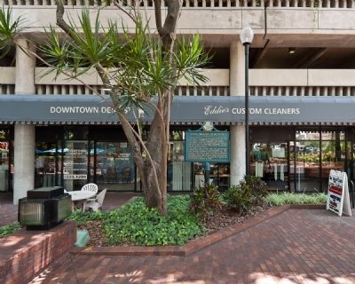
By R. C., August 2, 2010
Fort Brooke Cemetery Marker
| On North Franklin Street north of East Whiting Street, on the right when traveling north. |
| On East Street, on the right when traveling north. |
| On South Franklin Street south of East Whiting Street, on the right when traveling north. |
| Near North Franklin Street north of East Whiting Street, on the right when traveling north. |
| On South Franklin Street at Channelside Drive, on the right when traveling south on South Franklin Street. |
| On Bayshore Boulevard at Hyde Park Place, on the right when traveling north on Bayshore Boulevard. Reported permanently removed. |
| On East 8th Ave near Angel Oliva Senior Street, on the right when traveling west. |
| On North 13th Street at East 5th Avenue, on the left when traveling south on North 13th Street. Reported missing. |
| On East Fowler Avenue at Harney Road, on the right when traveling east on East Fowler Avenue. |
| Near U.S. 301 at Stacy Road. |
| On State Road 60 (State Road 60) 0.6 miles east of 130th Avenue, on the right when traveling east. |
| Near Florida Route 2 1 mile east of Timberlake Road, on the right when traveling east. |
| On Blue Hole Drive 1 mile west of Caverns Road, on the right when traveling west. |
| On State Road 40 0.3 miles west of the Astor Bridge, on the right when traveling east. |
| On South Central Avenue (State Road 19) at Golden Gem Drive, on the right when traveling north on South Central Avenue. |
| On Cape Coral Parkway East 0.2 miles east of Southeast 17th Place, on the right when traveling west. |
| On First Street (Florida Route 80) at Jackson Street, on the left when traveling west on First Street. Reported missing. |
| On Blountstown Highway (State Road 20) 0.1 miles Five By Five Drive, on the right when traveling east. |
| Near West Tennessee Street at Mission Road. |
| Near Champions Way at West Pensacola Street. |
| Near South Pedrick Road 0.7 miles east of Stoney Creek Way. |
| On Monroe Street at Apalachee Freeway on Monroe Street. |
| On E. Park Avenue at S. Monroe Street, in the median on E. Park Avenue. |
| On Pisgah Church Road 0.1 miles east of Shady Lane, on the right when traveling west. |
| On Chaires Cross Road (State Road 154) 0.2 miles west of Parkhill Road, on the right when traveling east. |
| On U.S. 90 0.1 miles west of Northwest Elizabeth Sims Loop, on the right when traveling east. |
| On East Base Street (U.S. 90) east of Northeast Range Avenue, on the right when traveling west. |
| Near Fort Hamer Road 0.1 miles south of Rive Isle Run. |
| Near Fish Hook Cove 0.3 miles north of Waterlefe Boulevard, on the left when traveling north. |
| Near 119th Street W. south of Cortez Road W. ( Highway 684), on the left when traveling south. |
| On Bayshore Drive at Boots Point Road, on the left when traveling north on Bayshore Drive. |
| Near East Fort King Street at SE 39th Terrace, on the left when traveling east. |
| Near East Fort King St at SE 39th Avenue, on the left when traveling east. |
| Near East Fort King Street 0.1 miles south of East Silver Springs Boulevard. |
| Near East Fort King Street at SE 39th Avenue. |
| Near East Fort King Street 0.1 miles south of East Silver Springs Boulevard. |
| Near Southeast 80th Street (County Road 328) at South Pine Avenue (U.S. 441), on the right when traveling east. |
| Near Southeast 80th Street (County Road 328) at South Pine Avenue (U.S. 441), on the right when traveling east. |
| Near Southeast 80th Street (County Road 328) at South Pine Avenue (U.S. 441), on the right when traveling east. |
| Near East Fort King Street 0.1 miles south of East Silver Springs Boulevard. |
| Near East Fort King Street 0.1 miles south of East Silver Springs Boulevard. |
| Near East Fort King Street at SE 39th Avenue, on the left when traveling east. |
| On East Fort King Street at Southeast 39th Terrace, on the right when traveling west on East Fort King Street. |
| Near East Fort King Street at SE 39th Avenue. |
| Near East Fort King Street at SE 39th Avenue, on the left when traveling east. |
| Near Southeast 80th Street (County Road 328) at South Pine Avenue (U.S. 441), on the right when traveling east. |
| On East Fort King Street 0.1 miles south of East Silver Springs Boulevard. |
| Near East Fort King Street at SE 39th Terrace, on the left when traveling east. |
| Near East Fort King Street at SE 39th Terrace, on the left when traveling east. |
| Near East Fort King Street at SE 39th Avenue, on the left when traveling east. |
| Near East Fort King Street at SE 39th Terrace, on the left when traveling east. |
| Near East Fort King Street at SE 39th Avenue, on the left when traveling east. |
| Near East Fort King Street at SE 39th Avenue. |
| Near East Fort King Street at SE 39th Avenue, on the left when traveling east. |
| Near East Silver Springs Boulevard at NE 58th Avenue, on the right when traveling east. |
| Near Northeast 29th Place 0.5 miles south of East Silver Springs Boulevard (State Highway 40). |
| Near East Silver Springs Boulevard (Florida Route 40) at NE 57th Avenue, on the right when traveling east. |
| Near Cape Florida Park Boulevard at South Crandon Boulevard, on the left when traveling south. |
| On Cape Florida Park Boulevard south of Crandon Boulevard. |
| Near Northwest North River Drive at Northwest 3rd Street, on the right when traveling north. |
| Near Virginia Beach Drive 0.4 miles north of Rickenbacker Causeway (State Road 913), on the right when traveling north. |
| Near Northwest North River Drive at Northwest 3rd Street, on the right when traveling north. |
| On West Flagler Street at NW Miami Court, on the left when traveling east on West Flagler Street. |
| On South Dixie Highway (U.S. 1) at SW 160th Street, on the right when traveling north on South Dixie Highway. |
| On Overseas Highway (U.S. 1 at milepost 79), 0.3 miles north of Davis Lane, on the right when traveling south. |
| Near Overseas Highway (U.S. 1) north of North Ocean Lane (County Route 931), on the right when traveling south. |
| On Overseas Highway (U.S. 1 at milepost 71), 1.5 miles south of Old State Road 4a, on the left when traveling south. |
| On Overseas Highway (U.S. US1 at milepost 79), 0.3 miles north of Davis Lane (Local Route 961), on the right when traveling south. |
| Near Wall Street at Tifts Street. |
| Near Angela Street at Quay Road. |
| On Southeast 38th Avenue 0.2 miles north of U.S. 98/441, on the right when traveling north. |
| Near Southeast 38th Avenue 0.2 miles north of U.S. 98/441, on the right when traveling north. |
| On Southeast 38th Avenue 0.2 miles north of Route 98/441, on the right when traveling north. |
| On Southeast 38th Avenue 0.2 miles north of U.S. 98/441, on the right when traveling north. |
| Near North Fort Christmas Road 0.1 miles north of Christmas Cemetery Road, on the left when traveling north. |
| Near North Fort Christmas Road 0.1 miles north of Christmas Cemetery Rd, on the left when traveling north. |
| Near North Fort Christmas Road (State Road 420) 1.8 miles north of East Colonial Drive (State Road 50). |
| Near North Fort Christmas Road 0.1 miles north of Christmas Cemetery Road, on the left when traveling north. |
| Near North Fort Christmas Road (County Route 420) 0.1 miles north of Christmas Cemetery Road, on the left when traveling north. |
| On South Conway Road (State Road 15) at Gatlin Avenue, on the right when traveling south on South Conway Road. |
| On S. Orlando Avenue (U.S. 17 & 92) at Lake Lily Drive, on the right when traveling north on S. Orlando Avenue. |
| On Lake Lily Drive west of South Orlando Avenue (U.S. 17/92), on the right when traveling west. |
| Near Lake Lily Drive (now a footpath). |
| On Gatlin Avenue at South Summerlin Avenue, on the left when traveling east on Gatlin Avenue. |
| On South Ferncreek Avenue south of Stevens Avenue, on the left when traveling south. |
| On Kempfer Road south of E. Bronson Highway (U.S. 192), on the left when traveling south. |
| On Tallahassee Boulevard south of Old Tampa Highway, on the right when traveling south. |
| Near Lakeview Drive at Ruby Avenue, on the right when traveling north. |
| On Old Dixie Highway (State Road 811) 0.2 miles south of Federal Highway (U.S. 1), on the right when traveling north. |
| Near West Indiantown Road (State Road 706) 1.3 miles west of Florida's Turnpike (Interstate 95), on the left when traveling west. |
| On Clocktower Drive at West Indiantown Road (State Road 706), in the median on Clocktower Drive. |
| Near West Indiantown Road (State Road 706) 1.3 miles west of Florida's Turnpike (Interstate 95), on the left when traveling west. |
| On Jupiter Lighthouse Park west of Coast Guard Way, on the right when traveling east. |
| On Winding Lake Drive 0.1 miles east of Cassie Holy Court, on the right when traveling east. |
| On Jupiter Lighthouse Park at Coast Guard Way, on the right when traveling east on Jupiter Lighthouse Park. |
| On Jessamine Road 1.5 miles south of Blanton Road (County Route 41), on the right when traveling west. |
| On Fort King Road just north of Grassy Hill Lane, on the right when traveling south. |
| On U.S. 98/301 at Bluegrass Road, on the right when traveling north on U.S. 98/301. Reported missing. |
| On Withlacoochee Boulevard 0.1 miles south of River Road, on the right when traveling east. |
| On Fort King Road at Poinsettia Avenue, on the left when traveling south on Fort King Road. |
3301 entries matched your criteria. Entries 401 through 500 are listed above.
⊲ Previous 100 —
Next 100 ⊳
