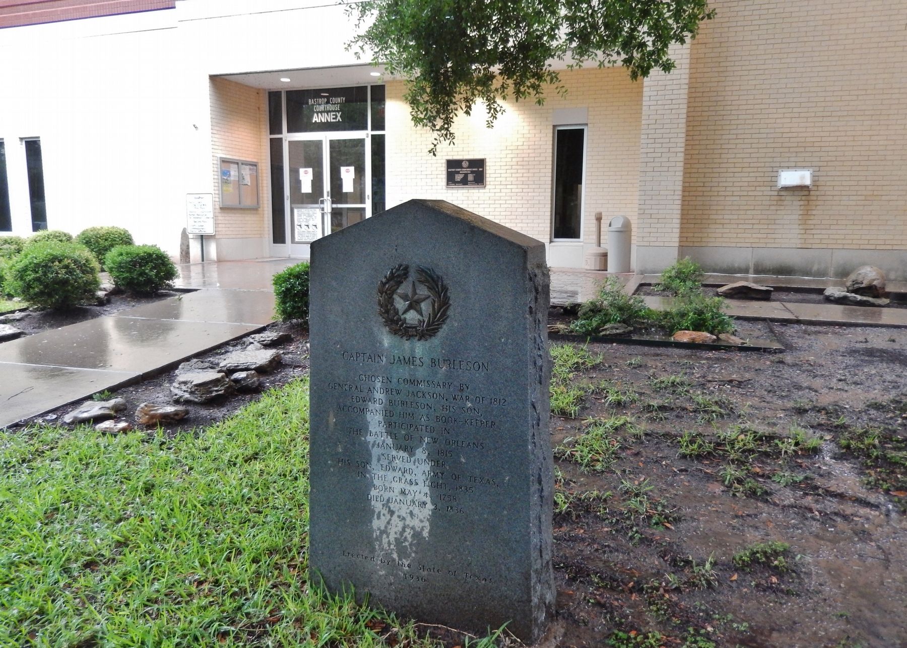
On Pecan Street north of Walnut Street, on the right when traveling south.
Chosen commissary by
General Andrew Jackson, War of 1812
Edward Burleson, his son,
accompanied him as book-keeper
Participated in
the Battle of New Orleans
January 8, 1815
Served under
his son, Edward, Army of Texas,
in the Grass . . . — — Map (db m111111) HM
On Loop State Highway 150 at Park Road 1, on the right when traveling west on State Highway 150.
Long before white men arrived, this region was inhabited by Tonkawa and Comanche Indians. In 1691 the first Spanish explorers crossed this territory en route to east Texas. From their route, parts of “El Camino Real” (the King's . . . — — Map (db m126751) HM
On Park Road 1-A 0.6 miles east of Loop Texas Highway 150 when traveling east.
Erected in recognition of the
distinguished service to Texas of
Felipe Entrique Neri,
Baron De Bastrop
1770 - 1829
Pioneer Red River empresario. Land commissioner of Austin's colony. Member of the Congress of Coahuila and Texas. In . . . — — Map (db m111113) HM
Near State Highway 95 0.1 miles north of Farm Street.
Army of Texas • Participated in the Capture of Goliad October 9, 1835 • Signer of the Goliad Declaration of Independence • Born in Tennessee, 1810 • Died 1849 — — Map (db m195970) HM
On Farm to Market Road 20 0.1 miles north of Humble Lane (County Highway 232), on the right when traveling north.
Early land grantee in this area. Of Dutch descent, he was born in Virginia. Came to Texas (then part of Mexico) in 1831 as a colonist of Stephen F. Austin, the "Father of Texas."
Received a Spanish league of land (4,444 acres) here. Active in . . . — — Map (db m118406) HM
On Walnut Street at Hill Street, on the right when traveling west on Walnut Street.
Thomas H. Mays was born in 1802 in Virginia and emigrated to Texas from Tennessee in 1830. In 1834, he became Bastrop's first municipal surveyor and platted the city's new streets. Two years later, he was wounded in the leg at the Battle of San . . . — — Map (db m65221) HM
On Farm to Market Road 969 0.2 miles west of Upper Elgin River Road (County Route 127), on the right when traveling east.
Signer of the Texas
Declaration of Independence
Aide-de-camp to Gen. Houston at
San Jacinto
Commander of a regiment of Rangers
1836-37
Here his widow
Mrs. Elizabeth Coleman
and son, Albert V. Coleman
were killed by Indians
and . . . — — Map (db m82688) HM
Near Jeddo Road (County Highway 297) 0.2 miles north of Farm to Market Road 713.
Born April 24, 1806 Came to Texas in 1835. A soldier in the Texas War for Independence before and during the Siege of Bexar 1835 and participated in the Battle of San Jacinto 1836 Died April 6, 1870 His wife Louranie Darling Born June 10, 1810 . . . — — Map (db m180695) HM
On Waco Street at Old Highway 20 (Farm to Market Road 333), on the left when traveling east on Waco Street.
Born in Tennessee, friend of David Crockett, Jesse Billingsley came to Texas in 1834. Known as a fearless Indian fighter, Billingsley was elected captain of the Mina Volunteers, Company C, of the Republic of Texas Army. At the Battle of San Jacinto, . . . — — Map (db m205479) HM
On Farm to Market Road 2571 at Young School House Road (County Road 280), on the right when traveling west on Road 2571.
Maryland native Stephen Scallorn (1787-1887) lived in Kentucky and Tennessee, where he practiced medicine and was active in the Primitive Baptist Church, before moving to Texas. He was attracted to the Republic by the favorable accounts of his . . . — — Map (db m160302) HM
Built in 1890 by Will H. and Julia George of materials from early house on land inherited from her father, Maj. J.H. Wood (Texas Cattle Empire Builder) who came from New York to join Texas War for Independence. Remodeled in 1900, house is raised . . . — — Map (db m207402) HM
Named by the Spaniards about 1800 because of its midway position between the San Antonio and Nueces Rivers. Rises in Karnes County; empties into Mission River. Crossed by explorers, padres, soldiers, settlers who traveled on three early ox-cart . . . — — Map (db m202009) HM
On South Penelope Street at E Ave East on South Penelope Street.
San Jacinto Veteran born in Tennessee, 1814, died in 1858. His wife Amanda Isbell. Born April 8, 1819, died September 1, 1880. — — Map (db m286837) HM WM
On East Avenue E east of South Penelope Street, on the left when traveling west.
Widow of William Hardin
before her marriage to
Dr. O.P. Kelton
Many of the Mexican officers
and men were placed in the
care of Judge and Mrs. Hardin
after the victory at San Jacinto
and were mercifully treated by them.
Born August . . . — — Map (db m152194) HM
Near North Main Street (State Highway 317) north of East 15th Avenue, on the left when traveling north.
Texas revolutionary veteran and local merchant Norman Austin made important contributions to his adopted state. Born in Skaneateles, New York, he was the fifth son of a large family and traveled widely throughout his life. He farmed in Michigan and . . . — — Map (db m152240) HM
On South Main Street at Water Street on South Main Street.
(right side)
Fought at San Jacinto April 21, 1836. Assistant Inspector General and Inspector General of the Texas Army 1837-1839. Captain of Texas Rangers and Lieutenant Colonel of Mounted Volunteers in the Mexican War 1845-1846. Colonel . . . — — Map (db m258922) HM
A native of South Carolina, Wilson Van Dyke served as a member of the Somervell Expedition, which was organized in 1842 to expel the Mexican Army from Texas. Under command of Col. W.S. Fisher, he crossed the Rio Grande and was captured. A survivor . . . — — Map (db m29382) HM
On South Main Street (Farm to Market Road 2268) at College Hill Drive, on the right when traveling north on South Main Street.
Elijah Sterling Clack Robertson was born in Giles County, Tennessee, August 23, 1820. His father, Empresario S.C. Robertson, brought him to Texas to learn Spanish and to help him in his land office translating and copying land grants to Spanish. For . . . — — Map (db m212459) HM
Near South Main Street (Farm to Market Road 2268) at College Hill Drive, on the right when traveling north.
Under the sheltering trees on this hill, Mary E. Robertson and Thomas S. Sutherland met and studied at Thomas Arnold High School graduating in 1906 and 1910, married in the Robertson Homeplace uniting two families whose ancestors settled in Texas . . . — — Map (db m212453) HM
Spanish soldiers saved this 18th century cannon from a shipwreck in Matagorda Bay off the Texas coast in 1817. It was brought to San Antonio where it was later captured by Texian forces during the Siege and Battle of Béxar (1835). The following . . . — — Map (db m250782) HM
These iron 4 pound cannon replicas are based on the measurements of the cannons recovered in 1852 by Samuel Maverick near the northwest corner of the Alamo. Archival research indicates that these cannons were on site but not in use during the Battle . . . — — Map (db m188609) HM
During excavations in 2019, archaeologists discovered intriguing fragments of plaster amongst the dirt. These fragments weren't white, as might be expected of soldier's barracks.
Curious, the Alamo's conservator Pam Rosser inspected the . . . — — Map (db m250785) HM
Near Alamo Plaza 0.1 miles south of East Houston Street.
As the granddaughter of Lorenzo de Zavala (1789-1836), first vice-president of the Republic of Texas, young Adina de Zavala was exposed to vivid accounts of Texas' revolutionary and republican past. She became a guiding force in the preservation . . . — — Map (db m61083) HM
On Alamo Plaza, on the right when traveling north.
Mission San Antonio de Valero, established nearby in 1718, was relocated here in 1724. By 1762, the mission plaza was enclosed by thick stone and adobe walls. The 11x14-foot main gateway was located at this site along the south wall. In 1803 . . . — — Map (db m30713) HM
March 6, 1836 - - - - March 6, 1986
Commemorating the sesquicentennial of the Battle of
the Alamo by the Daughters of the Republic of Texas
"I shall never surrender or retreat. Then, I call on you in the name of liberty, of patriotism . . . — — Map (db m232293) WM
At this location an exciting discovery was made. Approximately two feet below the current surface archaeologist recently uncovered a circular stone platform - but what is it?
Alamo archaeologist Kristi Nichols explains, "It appears to be . . . — — Map (db m188522) HM
On Alamo Plaza at East Crockett Street, on the right on Alamo Plaza.
By 1835, tensions between those in Mexico who supported republican ideals and the centralist Mexican government had escalated into all-out war. Seeking their independence, Texan revolutionaries won the town of San Antonio de Béxar from . . . — — Map (db m188616) HM
Spanish soldiers saved this 18th-century cannon from a shipwreck in Matagorda Bay located off the Texas coast in 1817. It was brought to San Antonio where it was later captured by Texian forces during the Battle of Béxar (1835). The following year, . . . — — Map (db m188593) HM
On Alamo Plaza at East Crockett Street on Alamo Plaza.
Typical of the type of cannon purchased by merchants during the 18th century to guard ports and ships, this 4 pounder was cast in Great Britain sometime after 1725. It was used by the Texans during the 1836 Battle of the Alamo. Once Texas won its . . . — — Map (db m227651) HM
On Alamo Plaza at East Crockett Street on Alamo Plaza.
Characteristics of this light cast-iron cannon are similar to ones produced in Sweden for the commercial market in the 18th century. Any distinguishing maker marks have been lost. It likely came to Texas through trade, capture, or purchase. Found . . . — — Map (db m227658) HM
On Alamo Plaza at East Crockett Street on Alamo Plaza.
Characteristics of this light cast-iron cannon are similar to French patterns produced for the commercial market during the late 18th century. It likely came to Texas through trade, capture, or purchase. It was found in 1852 by workman digging in a . . . — — Map (db m227659) HM
Title to the Alamo Mission property,
acquired through her efforts and
her personal fortune, was conveyed by
Clara Driscoll
to the State of Texas, Sept. 5th 1905:
“That the sacred shrine be saved from the
encroachments of . . . — — Map (db m30734) HM
Whereas: The memory of Clara Driscoll will be immortal in the hearts of the Daughters of the Republic of Texas for the patriotic work which held her great interest, from her girlhood through her life.
Whereas: Clara Driscoll is known . . . — — Map (db m294971) HM WM
(Born August 1, 1809) sacrificed his life for Texas liberty while defending the north wall of the Alamo in the vicinity of the present day federal building (across Houston) on March 6, 1836. — — Map (db m188587) HM
David Crockett was a frontiersman who became a well-known politician and humorist in early 19th Century America. In a period of history that celebrated the rise of the common man, no common man rose higher from such humble beginnings. "Davy" . . . — — Map (db m188527) HM
On Alamo Plaza at East Crockett Street on Alamo Plaza.
In 1836, an 18-pounder cannon similar to the one seen here was mounted to defend the Alamo's southwest corner. The 18-pounder played a legendary role in the prelude to the battle. After a brief parlay, the Alamo's commanding officer Lt. . . . — — Map (db m188611) HM
On Alamo Plaza at East Crockett Street on Alamo Plaza.
25 years ago, engineers tried to block rising damp by pushing a special plate made of corrosion-resistant alloy through the Alamo Church's foundations. Today's excavations here will tell preservation architects how well this metal plate, called a . . . — — Map (db m227628) HM
All great nations have creation myths, the Republic of Texas was no different. Born in New Haven, Connecticut, Emily D. West was a free woman of mixed race. In 1835, she signed a one-year contract in New York City agreeing to work as a housekeeper . . . — — Map (db m232623) HM WM
The San Antonio de Padua Mission was founded in San Antonio in 1716 by the Franciscan Father, Antonio Olivares, and after merging with the San Francisco Solano Mission in 1718, it was officially founded as the San Antonio de Valero Mission. The . . . — — Map (db m9228) HM
The Treaty of Velasco mandated that all Mexican forces withdraw south of the Rio Grande. Before leaving the Alamo, however, Mexican troops destroyed much of what remained. For many years, the structure stood deserted as the affairs of the new . . . — — Map (db m188747) HM
As the twentieth century approached, the historic Alamo Shrine was surrounded by commercial property, and original parts of the mission were in danger of being lost forever. Adina De Zavala, granddaughter of the first vice president of the Republic . . . — — Map (db m188760) HM
Erected in grateful recognition of
the supreme act of heroism of the
thirty two men from Gonzales
who gave their lives in the Alamo
in response to the appeal of Travis.
Erected March 1, 1936 — — Map (db m30777) HM
On Alamo Plaza at East Houston Street on Alamo Plaza.
Hendrick Arnold, a free man of mixed race, emigrated from Mississippi in 1826, settling with his parents in Austin's Colony on the Brazos River. He played a key role in the Texas Revolution as a guide and spy for the Texian Army.
By 1835, . . . — — Map (db m232678) HM WM
This oak tree planted in the spring of 1965 in memory of the Heroes of the Alamo. Presented by the First Officers' Training Camp Association of Texas, Leon Springs, Texas, May 8...August 15, 1917. Roster of First Campers filed in Alamo Library. — — Map (db m30599) HM
On Alamo Plaza at East Commerce Street on Alamo Plaza.
Survivors Juana Navarro Perez Alsbury and son Alejo Perez, Jr. Bettie Dolores Cervantes Susanna Dickinson (Wife of Almeron Dickinson who died in the Alamo) and daughter Angelina Dickinson Ana Salazar Castro Esparza (Wife of Gregorio Esparza . . . — — Map (db m227737) WM
James Bowie represented the fluid nature of the frontier, born in Kentucky but living in Missouri and Louisiana before finally settling in Texas. Along the way, he gained a reputation as a deadly duelist with a knife.
Bowie traveled to Texas . . . — — Map (db m188534) HM
To the Memory of
The Heroes of the Alamo
[Poem in Chinese follows]
Japanese Monument
The story of the Alamo reaches far beyond the borders of Texas. More than 2.6 million visitors from around the world came to the Alamo in 1996. The . . . — — Map (db m30779) HM
On Alamo Plaza at East Houston Street on Alamo Plaza.
Virginia-born John William Smith gained fame for the role he played in early Texas history. Smith, nicknamed "El Colorado" for his red hair, arrived in Texas in 1827 and settled in San Antonio de Béxar. He became fluent in Spanish, moving easily . . . — — Map (db m188529) HM
Born to a prominent San Antonio family, Juan Nepomuceno Seguín led a life of service to his community. He was both a solider and politician, becoming Mayor of San Antonio in 1841.
During the Texas Revolution, Seguín supported independence. He . . . — — Map (db m188526) HM
Commandancy of the Alamo -
Bexar, Feby. 24th, 1836 -
To the people of Texas & all Americans in the world --
Fellow citizens and compatriots
I am besieged, by a thousand or more of the Mexicans and Santa Anna - I have sustained a . . . — — Map (db m78329) HM
Near Alamo Plaza north of East Crockett Street, on the right when traveling north.
Legend states that in 1836 Lt. Col. William Barret Travis unsheathed his sword and
drew a line on this ground before his battle-weary men stating: “Those prepared to
give their lives in Freedom’s cause, come over to me!” — — Map (db m123951) HM
On Alamo Plaza 0.2 miles north of East Commerce Street, on the right when traveling south.
This wall foundation of adobe bricks formed part of the Indian quarters built during the construction of the west wall of Mission San Antonio de Valero (the Alamo) in about 1750. During the Siege of the Alamo, February 23 to March 6, 1836, some of . . . — — Map (db m164441) HM
Guided by preservation architects, structural engineers, and stone experts, archaeologists have carefully excavated inside the Alamo's oldest building, the Long Barrack. Having revealed the foundations, the team could step in to assess their . . . — — Map (db m250781) HM
On North Alamo Street, on the right when traveling north.
A native of South Carolina; came to San Antonio in 1835; was guide for Ben Mailam and other leaders in first attack on San Antonio by Texas Army, Dec. 1835. As Bexar Delegate, Maverick signed Texas declaration of Independence at . . . — — Map (db m30608) HM
San Antonio, Texas, has a rich, but complex history. Part of this history is the number of nations that held sovereignty over the area, beginning with Spain and ending with the United States. Stell's mural includes symbols-buildings and . . . — — Map (db m188657) HM
Conserving the Alamo Church means expert teamwork - and the excavation in front of you is a perfect example.
This unit is against the outside of the Alamo Church north wall. Guided by preservation experts, the archaeologists' goal is to expose . . . — — Map (db m188588) HM
A native of Tennessee, Susannah Dickinson and her husband, Almeron, settled in Gonzales, Texas in 1831. The couple had one daughter, Angelina, prior to the Texas Revolution. Living in San Antonio de Béxar in February 1836, the family took shelter in . . . — — Map (db m188533) HM
In commemoration of the
150th Anniversary of Texas Independence
and in honor of the
Tennessee Volunteers
who gave their lives at the Alamo
on March 6, 1836
the Citizens of Tennessee
present this Tennessee Homecoming Tree and Plaque . . . — — Map (db m30775) HM
This is the Long Barrack, the oldest building in San Antonio. It was built in 1724 as a convento or residence for priests and was originally part of the Mission San Antonio de Valero, now known as the Alamo. Since then it has been used as a . . . — — Map (db m30743) HM
The Alamo
Mission San Antonio de Valero - famed as The Alamo - founded 1718 by Spanish Missionaries. Secularized 1793. Garrison for Spanish Cavalry and Flying Company of San Carlos de Parras y Alamo. Between February 23 and March 6, 1836, . . . — — Map (db m156704) HM
On Alamo Plaza at Houston Street, on the right when traveling north on Alamo Plaza.
In memory of the heroes who sacrificed
their lives at the Alamo, March 6, 1836,
in the defense of Texas.
“They chose never to surrender nor retreat.
These brave hearts, with flag still
proudly waving, perished in the flames
of . . . — — Map (db m30709) HM
Corrals for cattle and horses occupied this space during the famous 1836 Siege and Battle of the Alamo. Small fortifications provided cover for the Texans during the siege. The structures shown in the illustration are (left to right) the church, the . . . — — Map (db m30714) HM
The church of former Mission San Antonio de Valero had been converted into a powder magazine and artillery platform by the Mexican Army in the autumn of 1835 during the Siege of Béxar. Following the capture of the town in early December 1835, Texan . . . — — Map (db m30736) HM
On Alamo Plaza, on the right when traveling north. Reported missing.
The fortress known to history as “The Alamo” was originally built by the Spanish in the 18th Century. Named Mission San Antonio de Valero by Franciscan officials, the mission occupied this site from 1724 until it was closed in 1793. The mission . . . — — Map (db m30824) HM
On Crockett Street at Alamo Plaza, on the right when traveling west on Crockett Street.
One of the weakest points of the fortified former mission was an open space between the old church and the Low Barrack. During the Siege of Béxar, Mexican troops constructed a palisade, or double log-wall, to close the exposed area. The Texans . . . — — Map (db m30857) HM
1836 found the Texians struggling to organize a provisional government as a confident Santa Anna marched into San Antonio de Béxar and demanded that the Alamo garrison surrender. On March 6, Mexican troops attacked the Alamo, stormed its walls, and . . . — — Map (db m188690) HM
On Alamo Plaza at East Crockett Street on Alamo Plaza.
The wooden palisade was constructed by the Mexican Army in 1835, connecting the southwest corner of the Church and the eastern corner of the Low Barrack. This was an important fortification added to the Alamo in an area that was not protected . . . — — Map (db m227688) HM
Upon the death of his father in 1821, Stephen F. Austin brought American settlers to Texas. Mexico first encouraged immigration for colonists willing to become citizens under the Mexican Constitution of 1824. This democratic document gave power to . . . — — Map (db m188684) HM
William Barret Travis accomplished much before his death at the Alamo in 1836. A native of South Carolina, Travis was raised in Alabama where he taught school, edited a newspaper, and passed the bar all before turning 21. He moved to Texas in 1831 . . . — — Map (db m188530) HM
On East Commerce Street east of South Alamo Street.
On this spot bodies of heroes slain at the Alamo were burned on a funeral pyre. Fragments of the bodies were afterward buried here. This tablet is the gift of relatives of Green B. Jemision and of other friends.
Second Marker
The De . . . — — Map (db m30589) HM
On West Commerce Street at North San Saba, on the right when traveling west on West Commerce Street.
Right Panel Preeminent Hero of Texas A man of rare initiative and courage • Of a modest and winning personality A devoted friend • Born in Frankfort Kentucky in 1788 Soldier in the War of 1812
Back Panel Trader with the . . . — — Map (db m257279) WM
On West Houston Street at North San Saba, on the right when traveling east on West Houston Street.
Captain of a Company of Infantry at San Jacinto Elected Colonel of Cavalry May 10, 1837 Born in Tennessee Sept. 12, 1812 Died at San Antonio Aug. 16, 1840 — — Map (db m179891) HM
On River Walk at W. Crockett Street on River Walk.
An old legend describes this twin cypress as a lookout of a Mexican sniper who picked off the Texans as they came to the river for water. — — Map (db m119152) HM
Alsbury, Young Perry (ca. 1814–1877)
Young Perry Alsbury, veteran of the battle of San Jacinto and the Mexican War, was born in Hopkinsville, Kentucky, around 1814, one of eleven children that included brother Horace Alsbury. He moved . . . — — Map (db m300917) HM
On Rigsby Avenue 0.2 miles west of Shrader Street, on the right when traveling east.
While assembling troops preparatory to the attack on the Mexican garrison at San Antonio • • After his appointment on November 12 as commissioner to the United States, the Texans, under Colonels Ben Milam and Frank W. Johnson stormed and captured . . . — — Map (db m207943) HM
San Jacinto veteran. Born in Kentucky, 1814. Died November 17, 1877. His wife Mary Rodriguez Alsbury. Born in 1832. Died in 1880. — — Map (db m300131) HM
Served in the Texas Army 1836 • • Was Mayor of San Antonio, 1847 - 1849 and 1852 - 1853 • Born in New Hampshire, January 17, 1811 Died in San Antonio, May 13, 1869 — — Map (db m177381) HM
On E. Commerce Street, on the left when traveling east.
A descendant of early Texas colonists, including a veteran of San Jacinto, Clara Driscoll was born in Refugio County and grew up as a wealthy rancher's daughter. In 1903, soon after returning from school in Europe, she learned that the Long . . . — — Map (db m30130) HM
Near East Commerence Street at North Monumental Street.
Served in the Army of Texas March 6, 1836 to November 16 1837 • Born in Swanton Vermont, September 4, 1815 Died April 15, 1876 Erected by the State of Texas — — Map (db m237182) HM
Near East Commerce Street 0.1 miles east of North Palmetto Street.
Native South Carolinian, pioneer doctor and editor, Republic of Texas Congressman, twice State Senator, Jack Hay's adjutant in War with Mexico, fearless Ranger Captain in border and Indian campaigns, Confederate colonel, Mayor of Austin and . . . — — Map (db m163782) HM
August Beisenbach, city clerk of San Antonio states that when he was an 8 year old boy playing on the Alameda (Commerce St.) he witnessed the exhuming of bodies or remains consisting of bones and fragments of bones, of victims of the siege of The . . . — — Map (db m163441) HM
Alejo de la Encarnación Pérez, infant son of Maria Juana Navarro Pérez, was the youngest known survivor of the 1836 Battle of the Alamo. From 1861 to 1864 Alejo served in the Confederate Army. After the Civil War he served the city of San Antonio in . . . — — Map (db m201644) HM
A Veteran of San Jacinto
Born in San Antonio
1797
Died November 1. 1879
His Wife Teresa Ramon Menchaca
Born in July, 1796
Died February 7, 1874 — — Map (db m201642) HM WM
Veteran in the Texas War for Independence 1835 - 1836 One of the Storming Party Who Entered Bexar December 5, 1835 an Honored Citizen Soldier and Ranger of Texas — — Map (db m201639) HM
A Signer of the Texas Declaration of Independence Born in San Antonio February 27, 1795 Died January 13, 1871 His Wife Margarita de la Garza Navarro Born October 17, 1801 Died July 8, 1861 — — Map (db m201641) HM WM
On U.S. 90 Access Road 1 mile east of Pinn Road, on the right when traveling west.
A Veteran of San Jacinto, and three of his companions were killed by Indians, as were seven members of a rescue party on the following day — — Map (db m201633) HM
A guide to the Texas Army 1835 • • Born in San Antonio, February, 1815 • • Died September 8, 1894 His Wife Micaela J. Olivarri Born June 10, 1844 Died May 5, 1917 — — Map (db m201645) HM WM
On West César E Chávez Boulevard at South Brazos Street, on the right when traveling east on West César E Chávez Boulevard.
Near this site on Nov. 26, 1835, occurred the Grass Fight, one of the least decisive but certainly most unusual battles of the Texas War for Independence. For more than a month, the Texan forces, composed of both Anglo- and Mexican-Texans, had . . . — — Map (db m201636) HM
1088 entries matched your criteria. Entries 101 through 200 are listed above. ⊲ Previous 100 — Next 100 ⊳