On Arciniega Street at South Presa Street, on the right when traveling east on Arciniega Street.
In 1810, Don Jose Miguel de Arciniega (1793- 1849), a maker of Texas, entered the Spanish military at the age of 17. After the Mexican War for Independence in 1821, Arciniega held many municipal posts, including San Antonio Alcalde in 1830 and . . . — — Map (db m309593) HM
On Arciniega Street at South Alamo Street, on the right when traveling west on Arciniega Street.
Built in 1810. On Jan. 22, 1811, Captain Juan Bautista de las Casas recruited forces here for first overthrow of Spanish rule in Texas by arresting governor, and other high officials.
On March 2, 1811, Juan Zambrano led counter revolutionary . . . — — Map (db m213309) HM
On King Philip Alley at East Nueva Street, on the right when traveling north on King Philip Alley.
Great early San Antonio leader, a native of North Carolina. Moved to Illinois, then to Missouri, where he was sheriff of Rawls County in 1824. Came to Texas with Green DeWitt in 1826 and settled at Gonzales.
Smith moved to San Antonio in 1828 . . . — — Map (db m82880) HM
On South Alamo Street at Villita Street, on the right when traveling south on South Alamo Street.
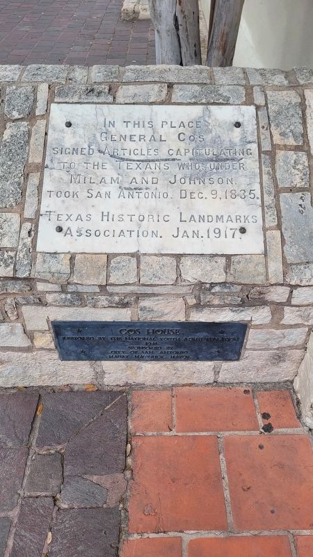
La Villita, “The Little Village”, settled about 1722 as “The Town of the Alamo". Here General Martin de Perfecto Cos signed the Articles of Capitulation to Texians December 11, 1835 and General Santa Anna's artillery battery . . . — — Map (db m82886) HM
The Ruiz House, built around 1745 originally stood at what is now 420 Dolorosa Street facing north on Military Plaza. It was occupied in about 1760 by a tailor, Juan Manuel Ruiz, who had come to San Antonio from Spain. José Francisco Ruiz, for . . . — — Map (db m239099) HM
On East Nueva Street at South Main Avenue, on the right when traveling west on East Nueva Street. Reported missing.
The administrative government of Bexar County, besides being the oldest in Texas, is distinguished by having served under nine governments. The community served under Spanish rule from May, 1718, until January, 1811, when it was taken over by . . . — — Map (db m53972) HM
On Dolorosa at Plaza de Armas, on the right when traveling east on Dolorosa.
One of two native Texans who signed Declaration of Independence and helped found Republic of Texas.
Ruiz, born in San Antonio, son of a wealthy rancher, was educated in Spain. Upon returning home, he was appointed school teacher by order of the . . . — — Map (db m130094) HM
On Dwyer Avenue at Kallison Walk, on the right when traveling north on Dwyer Avenue.
During the Main Plaza renovation in 2007, archaeologists discovered remnants of a military fortification underneath this street. This entrenchment would have been part of San Antonio's defense against attacks during the turbulent revolutionary . . . — — Map (db m30214) HM
On West Nueva Street east of South Main Avenue, on the right when traveling west.
Born in San Antonio; descendant of Frenchman who settled in Mexico before 1714. Always a civic leader, helped found first public school in San Antonio, 1812.
Went (1821) with Juan M. Veramendi to escort Austin Colony leaders to Bexar, and . . . — — Map (db m118112) HM
On East Commerce Street at Soledad Street, on the right when traveling west on East Commerce Street.
Here 56 Texans gathered in home of Samuel A. Maverick, Sept. 11, 1842, to defend city in surprise attack of 1800 Mexicans under Gen. Adrian Woll. Maverick and 52 others were captured and marched to Perote in southern Mexico. On March 30, 1843, . . . — — Map (db m118096) HM
The remains of the Alamo Heroes
are entombed in the chapel at the
left-hand side of the entrance to
this cathedral
Visitors Welcome — — Map (db m30343) HM
On Soledad Street at East Houston Street, on the right when traveling south on Soledad Street.
Erected on this site in 1734 for prominent Bexar citizens Geronimo and Javiera Cantu de la Garza, the de la Garza family home was designed by Geronimo's brother-in-law Pedro Flores Valdez. The complex occupied an entire city block and was crafted . . . — — Map (db m118527) HM
On Market Street at West Main Plaza, on the left when traveling east on Market Street.
On site chosen July 2, 1731, for "government houses" by people of San Fernando de Bexar, including newly-arrived settlers from the Canary Islands. Structure, erected 1742, had to be rebuilt in 1779 by Don Jose Antonio Curbelo, alcalde of the Villa . . . — — Map (db m20332) HM
Near Dolorosa Street 0.1 miles east of South Laredo Street.
1810
Beginning on September 16, 1810, with a call to arms delivered by Fr. Miguel Hidalgo, Mexican patriots in all parts of New Spain, including Texas, fought for independence from Spain.
1813
Of the several battles between . . . — — Map (db m214584) HM
On Dwyer Avenue at Kallison Walk, on the right when traveling north on Dwyer Avenue.
First of four major engagements of the War for Texas Independence, this sanguinary battle ended a siege of six weeks. The assault began at dawn, Dec. 5. 300 volunteers (Texans, Mexicans, and Americans) under Cols. Frank W. Johnson and Benjamin R. . . . — — Map (db m30211) HM
On Commerce Street at Main Avenue, on the left when traveling west on Commerce Street.
Mexico’s last invasion of the Republic of Texas alarmed San Antonio on Sept. 11, 1842, when Gen. Adrian Woll and 1300 troops struck the city from the west.
Awakened by booming cannon, 56 Texians (including judge, jurors, and citizens in town to . . . — — Map (db m30325) HM
On Old Pearsall Road (Farm to Market Road 2536) 0.2 miles east of Edwards Road, on the right when traveling west.
Samuel McCulloch, Jr. (1810-1893), wounded at the Battle of Goliad October 9, 1835, was one of the first casualties of the Texas Revolution. This site is part of land he received in 1850 as a bounty for his service. The oldest marked grave is that . . . — — Map (db m179924) HM
On Fitzhugh Road south of Montgomery Road when traveling south.
Hendrick Arnold and Samuel McCulloch, Jr.
Hendrick Arnold and Samuel McCulloch, Jr. played important roles in the Texas Revolution and the formation of the Republic of Texas. After Texas became independent, both were considered free Blacks, . . . — — Map (db m256505) HM
On Holbrook Road, on the left when traveling south.
Decisive in Texas history, was fought here, September 18, 1842. Col. Mathew Caldwell and Capt. John C. Hays, commanding a force of Texas volunteers, opposed the Mexican Army under General Adrian Woll that had captured San Antonio, and with the loss . . . — — Map (db m128119) HM
On Austin Highway (State Highway 368) at Corrine Drive, on the right when traveling south on Austin Highway.
Occurred in this vicinity on September 18, 1842 when Captain Nicholas Mosby Dawson and 53 men from La Grange, in attempting to join Captain Mathew Caldwell (Old Paint) and his company of Texas volunteers during the Battle of the Salado, were . . . — — Map (db m85981) HM
Near South Palmetto Avenue south of Wyoming Street, on the left when traveling south.
Came to Texas 1829. Served in Battles of Anahuac and San Jacinto in Texas War for Independence and the Indian, Mexican and Civil Wars. Born Natchez, Miss., Married Mary Ann Sawyer 1850. Prominent in Civic and Public Affairs.
Recorded - . . . — — Map (db m163736) HM
Near East North Loop Road 0.2 miles west of Wurzbach Parkway.
Came from South Carolina to Texas in 1834. Served in Battle of San Jacinto in Texas War for Independence, 1836. Was one of a party with Deaf Smith that destroyed Vince's bridge near Pasadena. This deed may have kept Santa Anna's army from retreat . . . — — Map (db m177129) HM
On Higgins Road at N Stahl Park, on the right when traveling north on Higgins Road.
This historic site is part of the bounty given to Louise Jackson for the supreme sacrifice of her husband, Thomas Jackson at the Battle of the Alamo.
The King's Highway passed on the western border of this cemetery which was the burial site . . . — — Map (db m295013) HM
On Leal Road 0.1 miles north of Martinez Losoya Road, on the left when traveling north.
Son of Alamo defender Gregorio Esparza, 11-year old Enrique, his mother, two brothers and sister were present at the seige by the Mexican Army (Feb 23 - March 6, 1836). Hidden in a pile of hay, the youth saw his father fall and witnessed the heroic . . . — — Map (db m208260) HM
On Theo Parkway 0.3 miles west of Mission Road, on the left when traveling west.
Erected by the State of Texas to Commemorate the Heroic Deeds of
Captain Richard Andrews Born in Sandersville Georgia in 1800. Fell at the Battle of Concepcion October 28, 1835.
The first sacrifice in the War of Texas Independence. Son . . . — — Map (db m216417) HM
On East Theo Avenue 0.3 miles west of Mission Road, on the right when traveling west.
Having Lost The Opening Skirmishes of the Texas Revolution at Gonzales and Goliad, the Mexican Army in Texas consolidated in San Antonio in October 1835. Texan troops also advanced to San Antonio and camped on the outskirts of town. On the . . . — — Map (db m216327) HM
Near Quesenberry Road 1.8 miles south of Somerset Road, on the right when traveling south.
Started in 1840's; still used by founding families. Graves include those of Texas patriots Francisco Antonio Ruiz, 1836 acting mayor, whose father and cousin signed Declaration of Independence; and Blas Herrera, who alerted the Alamo defenders to . . . — — Map (db m179892) HM
Born in Kentucky. Moved to Texas in 1833. In Texas Revolution he fought in Siege of Bexar (1835) and Battle of San Jacinto (1836). In 1842 took part in Somervell expedition against Mexico.
Resided at Washington-on-the-Brazos; present Kendall . . . — — Map (db m194072) HM
Tennessee native Roden Taylor Crain, a member of Capt. William Kimbro's company of San Augustine County volunteers, was a soldier in the struggle for Texas Independence from Mexico. He fought at the Battle of San Jacinto on April 21, 1836, and later . . . — — Map (db m233706) HM
On James Bowie Drive 0.1 miles east of North McCoy Boulevard (Texas Highway 8), on the right when traveling east.
Named for James Bowie (1799-1836), who fought for Texas freedom from 1819, when he joined the Long Expedition, to 1836 — when he died in defense of the Alamo.
Inhabited before 1800 by agricultural Indians, charted 1819 for . . . — — Map (db m96141) HM
On North State Line Avenue at Hazel Street, on the left when traveling north on North State Line Avenue.
Front
Hero of the Alamo
"They never fail who
die in a just cause"
Love of adventure
brought the young
South Carolinian to
Texas with James Long
in 1819. Romance made
of him a Mexican
citizen and won for
him in San . . . — — Map (db m96572) HM
On North Velasco Street (Business State Highway 288) at West Live Oak Street, on the right when traveling north on North Velasco Street.
Robert James Calder was born in 1810 to James H. and Jane E. (Caldwell) Calder in Baltimore, Maryland. His father died when he was a child, and Robert and his mother moved to Kentucky, where he was raised in part by his mother's family. They moved . . . — — Map (db m120660) HM
On Farm to Market Road 521 0.2 miles south of Cannon Road (Farm to Market Road 51), on the right when traveling south.
Kentucky native Albert Sidney Johnston graduated from the U.S. Military Academy at West Point in 1826. He was assigned to posts in New York and Missouri, and served in the Black Hawk War in 1832. He resigned his commission in 1834 to return to . . . — — Map (db m91921) HM
On N. Brooks Street (State Highway 36) at W. Smith Street, on the right when traveling south on N. Brooks Street.
(South Face of Monument)
Henry Smith was born in Kentucky, May Twentieth 1788, came to Texas in 1827 and settled in what is now Brazoria County which he regarded as his home until his death. He was severely wounded in the Battle of . . . — — Map (db m90101) HM
Near West Lake Jackson Road north of West Plantation Drive, on the right when traveling west.
Participated in the Battle of Velasco, 1832 · Member of the Convention of Texas, 1832 · President of the Convention of 1833 · Minister of the United States, 1836-1837 · Member of the 5th Congress of the Republic · Born in Virginia, 1806 · Died . . . — — Map (db m172703) HM
Near County Highway 8 0.1 miles south of Boone 6th Street.
Emigrated to Texas from Missouri in 1827 as an Austin Colonist • Participated in the Battle of Velasco, 1832 • Five of his sons were in the Army of Texas in 1836 • Born May 14, 1786 • Died in December, 1833 — — Map (db m290716) HM
Near County Highway 8 0.1 miles south of Boone 6th Street.
Born in Massachusetts. Came to Texas in 1831. Served in Texas Revolution at Siege of Bexar as Wagonmaster for Stephen F. Austin, "Father of Texas". Stole the bells of Mission Concepcion (Property of Mexico, Texas' enemy) to melt into bullets. Also . . . — — Map (db m158873) HM
Near Main Street (County Route 703) 0.1 miles south of Austin Street (County Road 300E), on the right when traveling north.
John Sweeny, Sr. (d. 1855) moved his family from Tennessee to Brazoria County, Texas, about 1833. With the help of slaves, he cleared his land and established a large plantation. This log cabin, originally located about 9 miles southwest of this . . . — — Map (db m49709) HM
On Main Street (County Road 703) at Austin Street (County Road 300E), on the left when traveling south on Main Street.
A structure erected in noted old river port town of Marion in Republic of Texas era. First portion, of hand-hewn cedar, was built about 1835 by colonist Thomas W. Nibbs. Merchant-civic leader-soldier Ammon Underwood (1810-87) bought and enlarged . . . — — Map (db m49707) HM
Near Quintana Street east of North Brazosport Boulevard, on the right when traveling east.
Erected by the State of Texas in memory of Colonel Robert M. Coleman
Signer of the Texas Declaration of Independence
Aide-de-Camp to General Sam Houston at San Jacinto
Colonel of the First Regiment of Texas Rangers
Born in Kentucky in . . . — — Map (db m173991) HM
On Skinner Street at North Avenue B, on the left when traveling north on Skinner Street.
Landing place of the "Lively" First vessel bringing immigrants to Austin's colony in 1821. There the Battle of Velasco, between Texas colonists and Mexican troops, was fought June 26, 1832. A treaty of peace between Texas and Mexico was signed . . . — — Map (db m167496) HM
On Karankawa Street at North Avenue C, on the left when traveling north on Karankawa Street.
One of oldest Texas towns. Port of entry for over 25,000 settlers, 1821-1835. Scene of first armed conflict leading to Texas Revolution, 1832. In mid-1800s, resort place for wealthy plantation families. Declined after the Civil War and 1875 . . . — — Map (db m167498) HM
Near Creek Drive west of Route 792, on the left when traveling west.
A Republic of Texas soldier during War for Independence. Born in Edgefield, S. C.; came to Texas in 1835. Entering army, he fought in famed victory of San Jacinto, April 21, 1836. He received headright and bounty lands in Brazoria, San Patricio, . . . — — Map (db m173108) HM
On State Highway 36 at Gulf Prairie Road and Peach Point Road, on the right when traveling east on State Highway 36.
Born in Missouri. Rode a mule to Texas in 1831 to join his uncle, Stephen F. Austin, Father of Texas. A private in Texas War for Independence. Legislator, congressman, member of Texas Secession Convention. Enlisted as a private in the Civil War, but . . . — — Map (db m53084) HM
Near Gulf Prairie Road 0.2 miles south of Texas Highway 36, on the left when traveling south.
Adjutant of the Texas army in Battle of Velasco, June 26, 1832. Wounded there, he was guarding civilians at time Texas won independence in Battle of San Jacinto, April 21, 1836.
A bosom friend of Stephen F. Austin, Caldwell received land . . . — — Map (db m90590) HM
Near Gulf Prairie Road 0.2 miles south of Texas Highway 36, on the left when traveling south.
In Texas War for Independence, joined Matamoros expedition of January 1836. In detachment that captured horses of Gen. Urrea of Mexican army, Brown was made captive in a counterattack, and spent 11 months in prison in Mexico, but finally escaped. . . . — — Map (db m90602) HM
Near Gulf Prairie Road 0.2 miles south of Texas Highway 36, on the left when traveling south.
Grandson of Moses Austin, whose dream of Anglo-American colony changed course of Texas history.
Came to Texas with his mother and stepfather in 1831; served in Texas army from 1835 to 1838. A highly successful planter, he was instrumental in . . . — — Map (db m111119) HM
After the Battle of San Jacinto, the ad interim government of the new Republic of Texas first convened in this building, also known as the American Hotel, and met with the imprisoned Santa Anna.
George B. Erath, later a San Jacinto veteran . . . — — Map (db m247304) HM
During the beginning of the Texas Revolution, a naval force was quickly assembled, based out of Quintana and Velasco.
Even before Texas declared its independence, in late 1835 the provisional Texian government adopted laws to create a . . . — — Map (db m246942) HM
On Parkview Road at Monument Ave. when traveling north on Parkview Road.
Stephen F. Austin landed back in Texas at the mouth of the Brazos River on 1-Sep-1835 after two years in Mexico (most of it in prison), sailing right into a sea battle between Texians and a Mexican gunboat, now termed the San Felipe Incident - . . . — — Map (db m270152) HM
The Texas Revolutionary Army built an artillery battery near this spot in early 1836, guarding the entrance of the Brazos River for the new Republic of Texas.
The fort existed for several years, through at least 1840: ... had an old . . . — — Map (db m243676) HM
After the Battle of San Jacinto, Santa Anna was held prisoner here and negotiated with the ad interim government of the new Republic of Texas at the nearby American Hotel.
Held prisoner with Santa Anna were several of his officers, . . . — — Map (db m244328) HM
On Monument Drive west of Jettyview Road, on the right when traveling west.
First vessel with emigrants to Austin's colony landed here December 23, 1821.
The Battle of Velasco was fought here June 26, 1832.
Public and secret treaties of peace between the Republic of Texas and General Santa Anna were signed here . . . — — Map (db m237185) HM
An important cause of the Texas Revolution occurred right here on the beach at the mouth of the Brazos River.
The San Felipe was a schooner of the Quintana trading firm McKinney, Williams & Company. Having foreknowledge of "Mexican . . . — — Map (db m246033) HM
On Monument Avenue when traveling west on Monument Avenue.
Here was fought a battle -- the first collision in arms between Texas colonists and the Mexican military -- a conflict preliminary to the Texas War for Independence.
On June 26, 1832, when Texans under John Austin and Henry Smith came down . . . — — Map (db m269478) HM
On East Brazos Avenue (State Highway 35) at North 17th Street, on the right when traveling west on East Brazos Avenue.
• Ratified the constitution
• Appointed committees
• Provided for protection from Indians
• Provided for the army and navy
• Created the judicial branch
• Created the postal department
• Created the land office
• Established a . . . — — Map (db m164582) HM
Near East Jackson Street 0.1 miles east of South 17th Street (State Highway 35).
Born in Massachusetts; came to Texas, 1834. As a young man, held odd jobs, survived 2 shipwrecks, and explored Texas countryside.
Fought in 1835 Siege of Bexar, Texas Revolution. Then settled here. Married Rachel Carson, 1839, by whom he had 4 . . . — — Map (db m286397) HM
Near East Jackson Street east of South 16th Street, on the right when traveling east.
Byrd Lockhart, Jr. moved to Green DeWitt’s Colony from Missouri around 1826 with several female relatives. He worked as a surveyor for the colony and settled in Gonzales, where he organized defenses against Indian attacks and supervised . . . — — Map (db m173015) HM
On South 17th Street (State Highway 35) at East Bernard Street, on the right when traveling north on South 17th Street.
In September 1836 Columbia, now known as West Columbia, became capital of the Republic of Texas. This took place with the removal of the ad interim government here from Velasco. After the election called by ad interim President David G. Burnet, the . . . — — Map (db m49703) HM
On East Brazos Avenue west of North 16th Street, on the right when traveling west.
In 1836 and 1837, the town of Columbia (Now West Columbia) served as the capital of the Republic of Texas. Josiah Hughes Bell, a colonist with Stephen F. Austin's Old Three Hundred, surveyed and platted Columbia in 1824 to serve as a center for . . . — — Map (db m41707) HM
On East Brazos Avenue (State Highway 35) west of North 16th Street, on the right when traveling west.
When ad interim President David G. Burnet selected Columbia to serve as
the capital for the first elected Congress of the Republic of Texas, Columbia
had a population of approximately 3,000. A group of businessmen promised accommodations for use . . . — — Map (db m164586) HM
On East Brazos Avenue (State Highway 35) at North 17th Street, on the right when traveling west on East Brazos Avenue.
Under Mexican rule, the municipality of Columbia was a part of
the Department of Brazos, State of Coahuila and Texas. In early
1830, the Mexican government imposed a series of new policies in
an effort to strengthen Mexico's hold on the . . . — — Map (db m164566) HM
On East Brazos Avenue at North 17th Street, on the right when traveling west on East Brazos Avenue.
General Santa Anna, the president of Mexico, posed one of the greatest
problems to the new republic. Captured following the Mexican army's defeat at San Jacinto, on April 21, 1836, Santa Anna and the Texas cabinet traveled aboard the steamboat . . . — — Map (db m164569) HM
Near East Jackson Street east of South 16th Street, on the right when traveling east.
New Yorker George Rounds served in Col. James W. Fannin's regiment in the Texas War for Independence but escaped the Goliad Massacre. He settled in Columbia, where he operated a tavern. Just before his death, he drew up a will devising his estate . . . — — Map (db m173039) HM
Near Oil Field Road (County Route 467) 0.5 miles east of Texas Highway 36W, on the right when traveling east.
A member of Austin's colony, 1829. Soldier in the Battle of Velasco; delegate to the General Convention, 1832; chief justice of Brazoria County, 1836. In this home, built about 1830, Stephen F. Austin died, December 27, 1836 — — Map (db m78618) HM
Near East Jackson Street south of South 16th Street, on the right when traveling east.
Faithful soldier, Texas War for Independence. He was in unit of Capt. Jacob Eberly, detailed by Gen. Sam Houston to guard Bell's Landing (East Columbia) until civilians could escape in front of Santa Anna's army. He and 15 others then hurried to . . . — — Map (db m173011) HM
Near East Jackson Street east of South 16th Street, on the right when traveling east.
Born in Georgia September 24, 1798 Died July 10, 1837 Delegate to the Consultation, 1835 Signer of the Texas Declaration of Independence, 1836 — — Map (db m173097) HM
On East Brazos Avenue (State Highway 35) at North 17th Street, on the right when traveling west on East Brazos Avenue.
A tribute to the fidelity of pioneer Masons whose outstanding
leadership laid the cornerstone of the Republic of Texas. These
great Masons gave us our freedom, our heritage, our liberty, and
strengthened our faith in God. No men could have . . . — — Map (db m164584) HM
Near East Jackson Street east of South 16th Street, on the right when traveling east.
Came to Texas in January, 1836 Led out to be shot with Fannin's men, March 27, 1836, but escaped Fought at San Jacinto in Captain William H. Patton's company Died in Columbia, December 27, 1836 — — Map (db m173082) HM
Near site of The First Capitol of the Republic of Texas
About 1833 Leman Kelsy built a story-and-a-half clapboard structure near this location. When Columbia became capital of the Republic of Texas in 1836, the building was one of two . . . — — Map (db m43057) HM
On E. Jackson St. 0.8 miles east of S. 17th, on the right when traveling east.
Site given by Josiah H. Bell family out of their grant, the first deeded to one of "Old 300" in colony of Stephen F. Austin. Has graves of many heroes of Texas Revolution of 1836.
Deeded in 1852 to Bethel Presbyterian Church. Since 1933 managed . . . — — Map (db m172990) HM
On Farm to Market Road 1301 at County Route 376, on the right when traveling south on Road 1301.
Zeno Phillips, one of Stephen F. Austin's "Old 300" colonists, acquired land here in 1829. Zeno and his brothers John Clark, Sidney, and James Ray (J.R.) Phillips, served in the Republic of Texas Army. The cemetery began with the burial of Zeno and . . . — — Map (db m96305) HM
On East Brazos Avenue (U.S. 35) at North 17th Street, on the right when traveling west on East Brazos Avenue.
The newly formed Republic of Texas faced many problems. With
no credit and no resources other than land, the republic had a
debt of 1.25 million dollars. Hostile Indians plagued the population. The new government appropriated $20,000 to . . . — — Map (db m164574) HM
On East Brazos Avenue (U.S. 35) at North 17th Street, on the right when traveling west on East Brazos Avenue.
In the August 9, 1836 issue of the Telegraph and Texas Register,
Stephen F. Austin, Henry Smith and Branch T. Archer were listed
as candidates for the office of president of the new republic.
Archer later withdrew and threw his support to . . . — — Map (db m164572) HM
On E. Brazos Avenue (State Highway 35), on the right when traveling west.
Following the signing of the Texas Declaration of Independence on
March 2, 1836 at Washington on the Brazos, an ad interim government was formed. Headed by President David G. Burnet and Vice
President Lorenzo de Zavala, this government . . . — — Map (db m164571) HM
On East Brazos Avenue (State Highway 35) west of North 16th Street, on the right when traveling west.
The Brazos River, whose formal name Brazos de Dios is Spanish for Arms of
God, is the longest river in Texas. As it wound its way through Texas, it witnessed the coming of the first Anglo settlers, the signing of the Texas Declaration of . . . — — Map (db m164587) HM
On East Brazos Avenue (State Highway 35) west of North 16th Street, on the right when traveling west.
A triple trunked live oak tree stood near the buildings which
housed the House of Representatives and Senate. Tradition holds
that the Texas Declaration of Independence was first read publicly
under this tree causing it to also be called . . . — — Map (db m164589) HM
On East Brazos Avenue at North 17th Street, on the right when traveling west on East Brazos Avenue.
In January of 1836, General Antonio Lopez de Santa Anna began gathering
troops on the Rio Grande River to begin his attempted take-over of Texas. Texans living in the southern parts of Texas began fleeing eastward to escape the invading Mexican . . . — — Map (db m164568) HM
Near North Texas Avenue at North Washington Avenue.
Isom Palmer, whose name has various spellings, was born to Martin and Sarah (Hardwick) Parmer. In 1825, the Palmer (Parmer) family moved to Texas, settling near Nacogdoches the next year, and participated in the 1826 Fredonian Rebellion. Palmer . . . — — Map (db m170312) HM
Near Boonville Road 0.1 miles east of Austins Colony Parkway.
Eli Seale 1793-1857
Elias (Eli) Seale was born in North Carolina in 1793. He served as a fifer in the War of 1812 in Mississippi, and in 1835 moved with his three brothers and his family from Alabama to Texas. He received his Mexican . . . — — Map (db m170484) HM
Near Boonville Road 0.1 miles east of Austins Colony Parkway.
On November 17, 1835, after Francis Smith convinced the people of Cincinnati, Ohio, to aid the cause of the Texas Revolution, the Ohioans began raising funds to procure two cannons and their attendant equipment for Texas. Since the United States . . . — — Map (db m170471) HM
On Steep Hollow Road at Texas Route 1179 on Steep Hollow Road.
Richardson Perry
Born in Mississippi — 1817
Died at the Alamo — 1836
On October 10, 1835, Perry received this league of land (4428 acres) as one of the Austin Colonists. This was one of the final Mexican land grants approved at San Felipe. The . . . — — Map (db m220452) HM WM
On High Prairie Road 1.6 miles west of Wellborn Road (Farm to Market Road 2154), on the right when traveling west.
Old Three Hundred Colonist William T. Millican was born in South Carolina about 1780 and came to Texas with his parents and siblings in 1821. They joined Stephen F. Austin's first colony and were granted land in this area on which to make their . . . — — Map (db m179148) HM
On South Broadway Street west of North Fisk Avenue, on the right when traveling west.
Donor of present townsite of Brownwood, Fisk was noted as a soldier, public servant, surveyor and businessman. The son of English parents, he was born in New York. As a boy he was so studious that he voluntarily gave up recess periods to read. In . . . — — Map (db m126061) HM
On West Fox Street east of South Echols Street, on the right when traveling east.
When Mexican Dictator Santa Anna revoked national rights, 30 or more men from this sparsely settled area left to resist his armies: in Grass Fight (Nov. 26, 1835), Siege of Bexar (Dec. 5-9) and other actions. While able men were absent, the foe . . . — — Map (db m201851) HM
On West Buffalo Street at S Thomas Street on West Buffalo Street.
A San Jacinto Veteran; founder of the city of Caldwell. Born in Virginia in 1811; died May 29, 1864. His wife Emily Hitchcock Chiles; born December 13, 1824; died June 9, 1877 — — Map (db m286838) HM WM
Near Farm to Market Road 1363 0.4 miles east of State Highway 36, on the left when traveling north.
Colonial statesman, Methodist lay leader, pioneer in Burleson County. Came to Texas in 1822 from Kentucky. Had office of surveyor, Austin's Colony, 1823 - 1836; was a military officer in Indian conflicts and also Army of Gen. Sam Houston during . . . — — Map (db m210617) HM
On E Jackson Street at North Pierce Street, on the left when traveling east on E Jackson Street.
Commandancy of the Alamo-
Bexar, Feby. 24th 1836-
To the people of Texas & all Americans in the world--
Fellow citizens & compatriots
I am besieged, by a thousand or more of the Mexicans under Santa Anna - I have sustained a continual . . . — — Map (db m285455) HM
Surrounded by a rock wall, the small pioneer family cemetery just west of this site is located on land that was once part of the William H. Magill homestead. Magill, a veteran of the Battle of San Jacinto, moved his family to Burnet County in . . . — — Map (db m27595) HM
Near Buchanan Drive (State Highway 29) at Fort Croghan Drive.
One of "Old 300" of Stephen F. Austin's first colony from Pennsylvania, took part in 1836 War for Texas Independence, he made and lost several stakes.
In 1851 bought a league and labor of Burnet County land, including site of Fort Croghan. . . . — — Map (db m29150) HM
1088 entries matched your criteria. Entries 201 through 300 are listed above. ⊲ Previous 100 — Next 100 ⊳