On U.S. 50 near Ice House Road, on the right when traveling west.
This was the site of a change station of the Pioneer Stage Company in the 1850’s and 1860’s. During 1860-1861, the Central Overland Pony Express maintained here the first pony remount station east of Sportsman’s Hall. — — Map (db m57977) HM
On South Shingle Road near Elvira Street, on the left when traveling east.
The youngest town acquisition of El Dorado County owes its origin to the Placerville and Sacramento Valley Railroad. They established a station for neighboring Amador County at this crossing of the roads. The town started on the completion of the . . . — — Map (db m19317) HM
These headstones, removed from their gravesites as a result of vandalism, were found throughout the county on roadsides and in backyards. The headstones have been given a temporary resting site, here, until their rightful places can be located. — — Map (db m13613) HM
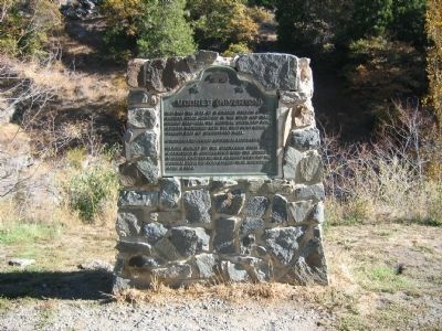
This city in the days of ’49
was called
“Hangtown”
This was the site of Elstner’s Hay Yard on which stood the ‘Hangman’s Tree’ where vigilantes executed many men for various crimes. The stump of the tree is under this . . . — — Map (db m10504) HM
On Coloma Street (State Hwy 49) at Bee Street, on the left when traveling north on Coloma Street (State Hwy 49).
[Marker facing Bee Street]
Placerville
Known as Hangtown
In the days of “49”
to
Sutter’s Fort
Sacramento
50 Miles
[Marker facing Coloma Street-State Hwy . . . — — Map (db m16024) HM
On Main Street at Sacramento Street, on the right when traveling east on Main Street.
Gold Rush town and Western Terminus of the Placerville – Carson Road to the Comstock. Placerville was a relay station of the Central Overland Pony Express, April 4, 1860 – June 30, 1861. Here on April 4, 1860 the first east-bound pony . . . — — Map (db m57973) HM
On Main Street at Cedar Ravine Road, on the right when traveling east on Main Street.
The Druids of California
Erected
This Memorial
to
Frederick Sieg
Who Instituted
the Order
in this State
A. D. 1859
Presented to the City of Placerville
Sept. 5, 1926 — — Map (db m16460) HM
On Green Valley Road at Deer Valley Road, on the left when traveling east on Green Valley Road.
With the discovery of gold on January 24, 1848, Coloma Road became one of the primary routes to the gold fields of El Dorado County. The road started at Sutter’s Fort (New Helvitia), then proceeded to Willow Springs (near Folsom), Mormon Island, . . . — — Map (db m11282) HM
On Green Valley Road at Deer Valley Road, on the right when traveling east on Green Valley Road.
Past this point on the Old Coloma Road, running between Sutter’s Fort and his sawmill on the American River, James W. Marshall rode with the first gold discovered at Coloma on Jan. 24, 1848. Traveled by thousands to and from the diggings, this road . . . — — Map (db m11268) HM
On Green Valley Road, on the left when traveling east.
This was the site of a popular roadhouse, where the ponies of the Central Overland Pony Express were changed during July 1, 1860 to June 30, 1861. From here the route of the pony riders continued westward to Folsom and eastward through Rescue, Dry . . . — — Map (db m10442) HM
Near Emerald Bay Road (State Highway 89), on the right when traveling north.
Tahoe’s Only Island
Over the last 100 years, Tahoe’s only island has been known by a number of names. In 1866, a group of young vacationers dreamed up the first name, Coquette, a word referring to a flirtatious or seductive woman. Attracted . . . — — Map (db m35090) HM
Near South Chance Avenue, 0.2 miles Kings Canyon Road, on the left when traveling south.
This memorial is dedicated to over 5,000 Americans of Japanese ancestry who were confined at the Fresno Fairgrounds from May to October 1942. This was an early phase of the mass incarceration of over 120,000 Japanese Americans during World War II . . . — — Map (db m165490) HM
Due north of here, now covered by the waters of the lake, was the site of Millerton, first County Seat of Fresno County 1856-1874 — — Map (db m52442) HM
In 1891, a posse shootout forced the infamous Dalton Brothers gang from this mountain hideout. They made their way back to Kansas where they eventually met their fate in Coffeyville. The outlaws, long since gone, leave Dalton Mountain as their . . . — — Map (db m27962) HM
On Front Street east of Sherman Avenue, on the right when traveling west.
California's first drilled oil wells producing crude to be refined and sold commercially were located on the north fork of the Mattole River approximately three miles east of here. The old Union Mattole Oil Company made its first shipment of oil . . . — — Map (db m51955) HM
On Beal Road near Telephone Road, on the right when traveling north.
This is the culmination of a personal religious intensity few mortals will ever experience. Started as a temporary monument to God's love in 1984 by Leonard Knight, it grew into the worldwide phenomenon you see before you.
Born on November 1, . . . — — Map (db m114541) HM
On Interstate 186, 0.2 miles south of Interstate 8, on the left when traveling south.
Alarcon's mission was to provide supplies for Francisco Coronado's expedition in search of the fabled Seven Cities of Cibola. The Spaniards led by Hernando De Alarcon ascended the Colorado River by boat from the Gulf of California past this point, . . . — — Map (db m88572) HM
As Avi-Milikit of Quechen legends; Picacho noted Spanish arrival in 1640, lured Sonora miners after 1852, brought steamboats to its mining and milling port until 1910. Her mines were never worked to extinction, but Picacho became a squatter haven. . . . — — Map (db m51576) HM
On Ballarat Road, 3.6 miles east of Trona Wildrose Road, on the left when traveling east.
Ballarat was born in eighteen ninety seven
following the discovery of the Radcliff Mine
in Pleasant Canyon.
Its namesake was the famous gold city
in Victoria Australia.
It was never a very large town.
It served Panamint Valley and Death . . . — — Map (db m159356) HM
On U.S. 395, 1 mile east of U.S. 395, on the left when traveling east. Reported missing.
In June 1873 Colonel Sherman Stevens built a sawmill and flume on Cottonwood Creek high in the Sierras directly west of this spot. The flume connected with the Los Angeles Bullion Road. The lumber from the flume was used for timbering in the mine . . . — — Map (db m33877) HM
On State Highway 127, 0.2 miles south of State Highway 190, on the right when traveling south.
This historic crossroad has been used by Indians, Clampers, Death Valley 49ers, ranchers, farmers, settlers and tourists. The town was originally called Amargosa. In 1907, the name was changed to Death Valley Junction. At this junction, the Tonopah . . . — — Map (db m78583) HM
On Badwater Road, 17 miles south of California Route 190, on the right when traveling south.
Good Life in Badwater
Water is rare and precious in Death Valley. Imagine the disappointment when a surveyor mapping this area could not get his
mule to drink from this pool. He wrote on his map that the
spring had "bad water," and . . . — — Map (db m159465) HM
Crystallized salts compose the jagged formations of this forbidding landscape. Deposited by ancient salt lakes and shaped by winds and rain, the crystals are forever
changing.
Listen carefully. On a warm day you may hear a metallic cracking . . . — — Map (db m158905) HM
On Titus Canyon Road, 15 miles west of Highway 374, on the right when traveling west.
The Roaring '20s, like the 1990s and
early 2000s, fueled an age of excess and
speculation, setting the stage for Leadfield,
a town built on dreams of wealth.
Lead deposits attracted prospectors to Titus
Canyon as early as 1905, but . . . — — Map (db m195240) HM
On California Route 190 at Borax Mill Road, on the left when traveling north on State Route 190.
On the marsh near this point borax was discovered in 1881 by Aaron Winters who later sold his holdings to W. T. Coleman of San Francisco. In 1882 Coleman built the Harmony Borax Works and commissioned his superintendent J. W. S. Perry to design . . . — — Map (db m158971) HM
On Racetrack Valley Road, 26 miles south of Ubehebe Crater, on the left when traveling south.
In front of you is a dry lake bed - a playa - the
flattest of all natural surfaces.
Fine mud and silt, eroded from the surrounding
mountain, compose the playa. Water washes across the
playa, suspending the sediments in a
shallow, . . . — — Map (db m235586) HM
Near California Route 190 near Greenland Boulevard, on the left when traveling north.
Furnace Creek is a spring fed stream flowing into Death Valley. Native Americans lived here centuries prior to its discovery by lost Forty Niners. In 1881, Aaron Winters found borax nearby, and sold his claims and water rights to William Tell . . . — — Map (db m159457) HM
Near this monument, Jayhawker group of Death Valley Forty-Niners, gold seekers from middle west, who entered Death Valley in 1849 seeking short route to mines of Central California, burned their wagons, dried the meat of some oxen and, with . . . — — Map (db m89481) HM
On Trona Wildrose Road at Ballarat Road, on the right when traveling north on Trona Wildrose Road.
Now a ghost town, Ballarat served nearby mining camps from 1897 to 1917. They produced nearly a million in gold. The jail & a few adobe ruins remain. Seldom Seen Slim, it's last resident, was buried in Boothill in 1968. It had a school but no . . . — — Map (db m159350) HM
On Trona Wildrose Road at Ballarat Road, on the right when traveling north on Trona Wildrose Road.
3 1/2 miles east of this point lies Ballarat. Established in 1897 as a mining camp and supply center for the gold and silver mines located on the western slope of the Panamint Mountains. It was named after a well-known gold producing area in . . . — — Map (db m159351) HM
On Trona Wildrose Road at Ballarat Road, on the right when traveling north on Trona Wildrose Road.
Rich sliver ore was discovered in December 1872 at the head of Surprise Canyon 12 miles northeast of here. The United States Senators for Nevada, John P. Jones and William Morris Stewart, invested in and promoted the camp which drew a peak . . . — — Map (db m159349) HM
Near 4310 Old Alfred Harrell Highway, on the right when traveling west.
These days restaurants come and go in the blink of an eye. But every so often a venue dishes up just the right mix of food and ambiance. Ethel's Old Corral is a perfect example of a restaurant getting it right. Great food, entertainment, customer . . . — — Map (db m89308) HM
On Buttonwillow Drive, 0.5 miles north of California Highway 58, on the left when traveling north.
A lone tree landmark on an old trans-valley trail. It was an ancient Yokuts Indian meeting place, later a location for white stock rodeos. Miller and Lux established their headquarters and store here about 1885. The town of Buttonwillow takes its . . . — — Map (db m50251) HM
On Bealville Road, on the right when traveling east.
Originally known as Allen's Camp after Gabriel Allen, who in the 1870s had a cabin and stock pasture near here, the settlement was named Caliente when railroad construction reached this point in April 1875. The town became a railroad terminal for . . . — — Map (db m157683) HM
This spring was on the old Indian Horsethief Trail and later (1834) Joe Walker Trail. The famished Manly-Jayhawk Death Valley parties (1849-50) were revived here after coming from Indian Wells through Last Chance Canyon. This was also a station on . . . — — Map (db m117039) HM
On Jacks Valley Road at White River Road, on the right when traveling west on Jacks Valley Road.
In 1854 John C. Reid filed a squatter’s claim on this spot. This same year Kern County’s first school class was held here. In 1859 David Lavers, with his father and brother, John, built a hotel and stage barn on the Old Bull Road. The crossing was . . . — — Map (db m25323) HM
Wm. B. Rose, in 1875, a mile east; built an adobe stage station on the site of the Overland Mail Way Station established 1858. From 1853 to 1875 site was known as Rancho Canoa (trough). Originally vaquero camp of the Sebastian Indian Reservation. . . . — — Map (db m20196) HM
On Grapevine Road West near Interstate 5, on the right when traveling north.
The Sebastian or Tejon Indian Reservation (headquarters 10 miles east of here) was established in 1853 by Gen. Edward Fitzgerald Beale as one of several California Reservations. The number of Indians quartered here varied from 500 to 2000. General . . . — — Map (db m108915) HM
On Caliente-Bodfish Road (County Route 483), on the right when traveling north.
Gold deposits at Havilah were discovered in 1864. Havilah was the county seat between 1866, when Kern County was organized, and 1872, when the government was moved to Bakersfield. Havilah was an active mining center for more than 20 years, and . . . — — Map (db m51821) HM
On Aerospace Highway (State Highway 14 at milepost 62.6), on the right when traveling south.
Indian water hole on Joseph R. Walker trail of 1834 where Manly-Jayhawker parties of 1849 found their first water after five days of travel from Argus Range. During 1860's was site of stage and freight station from Los Angeles to Coso and Cerro . . . — — Map (db m50243) HM
On California Route 178, on the left when traveling east.
Near this spot at the confluence of the north and south forks of the Kern River the Theodore Talbot Party of Captain John C. Fremont’s third expedition to the West camped for several weeks during December 1845 and January 1846. The river was named . . . — — Map (db m25092) HM
On State Highway 178, on the left when traveling east.
Located to the northwest of here, Isabella, a ranching and mining town, was named by Steven Barton in 1893, after Queen Isabella of Spain, Patron of Christopher Columbus. A post office was established here in 1896. In 1953 the community was moved a . . . — — Map (db m76872) HM
On Red Mountain Road, 0.8 miles west of U.S. 395, on the left when traveling west. Reported permanently removed.
Rand Camp began as a tent city, erected by eager miners who rushed to the Mojave Desert following a major gold discovery in April 1895. A year later, the town of 1,500 had been renamed "Randsburg." Saloons sprouted, a U.S. Post Office was . . . — — Map (db m153141) HM
On Old Town Road at Woodford Tehachapi Road, on the right when traveling north on Old Town Road.
The oldest settlement in Tehachapi Valley, known as 'Old Town,' was established here during the 1860s. It was long an important station on the road between Southern California and the San Joaquin Valley. The community began to decline when residents . . . — — Map (db m139964) HM
On Cameron Canyon Road, on the right when traveling east.
First Panel:
Wind Development
Why Tehachapi Pass?
1) Close to Energy Users
The proximity of Tehachapi Pass to the Los Angeles Basin makes it an attractive location for wind power development, as it reduces the length, . . . — — Map (db m63166)
On Glennville-Bakersfield/Granite Road, on the right when traveling south.
Built it 1873 by John Elden, this stand of buildings served as store, restaurant, and lodging place on the stage route between Bakersfield and Glennville. In later years it became a stopping place for freighters and sheepmen who were on their . . . — — Map (db m25716) HM
On State Highway 29, 6 miles north of Middletown, on the right when traveling north.
Oldest building in Lake County. Erected of stone in 1853-4 by Robert Sterling, whose wife was first white woman in Coyote Valley. Rebuilt in 1894. Headquarters of the Guenoc Land Grant and the first store in the valley. — — Map (db m16127) HM
Near Lake Vista Drive just south of Mulholland Highway, on the left when traveling south.
A Future President’s Ranch
By 1951, then actor Ronald Reagan purchased several parcels creating the approximately 357-acre ranch that spreads out before you and runs for 1.5 miles along Mulholland Highway. For the next ten
years, . . . — — Map (db m236739) HM
On Santa Rosa Avenue at Alameda Street, on the right when traveling north on Santa Rosa Avenue.
The 135 Deodar Cedar trees were planted in 1885 by the Woodbury Family, the founders of Altadena. First organized by F.C. Nash in 1920, the "Mile of Christmas Trees" has been strung with 10,000 lights each holiday season through the efforts of . . . — — Map (db m143798) HM
Near Explorer Road, 0.5 miles north of Windsor Avenue.
Who was Robert Owens of El Prieto Canyon?
In Spanish, "Prieto" means dark. El Prieto Canyon references a person, not the dark shade of its
many mature oak trees. The "El Prieto" of this beautiful canyon was a man named Robert Owens. . . . — — Map (db m226463) HM
Cape of Good Hope (top photo)
The Stone Wall that can be seen below you to the right of
the road cut through the ridge is part of a sharp 200 degree curve.
This enabled the railway to cross from Las Flores Canyon (beyond
ridge) to . . . — — Map (db m247616) HM
On Wilshire Boulevard at Santa Monica Boulevard, on the left when traveling east on Wilshire Boulevard.
The Tongva Native American Indian in prayer on top of The Electric Fountain is symbolic of an Indian rain prayer and pays homage to the area’s early inhabitants whose settlements, dating back to the 1500’s, were along the streams that flowed . . . — — Map (db m183120) HM
On East Olive Avenue at Third Street, on the right when traveling east on East Olive Avenue.
Burbank's first City Hall was built here in 1916. The building housed the offices of the City Council and City Manager, and was also home to the Police and Fire Departments. In 1943, these offices were relocated to the present-day City Hall across . . . — — Map (db m57665) HM
On South Alameda Street, on the right when traveling north.
[The arch way leading to the grounds is flanked by two markers:]
Right Marker:
Domínguez Ranch House
Central portion built in 1826 by Manuel Domínguez.
Rancho San Pedro
Ten square leagues granted, . . . — — Map (db m64857) HM
On Braddock Drive at Le Bourget Drive, on the right when traveling east on Braddock Drive.
This land was first traversed by Native Americans, called Tongva, (later known as the Gabrielinos). Under Spanish rule, it was settled as a portion of Rancho La Ballona. After Culver City was incorporated in 1917, the property became a horseracing . . . — — Map (db m49961) HM
On Main Street north of Culver Boulevard, on the right when traveling north.
Once a part of Rancho La Ballona, Main Street was so recorded in 1913, through the efforts of real estate developer Harry Culver, our city's founder. It was the hub of our city and the street address of the Harry Culver Co. In 1924, the 6-story Hunt . . . — — Map (db m51858) HM
On Jefferson Boulevard east of Cota Street, on the right when traveling north.
The Lugos, a Spanish landgrant family, arrived in the pueblo de Nuestra Señora la Reina de Los Angeles in the 1700's and settled prior to 1900 on this site. This was originally a portion of Rancho La Ballona which was established by the Machados. . . . — — Map (db m51869) HM
On East Huntington Drive (Old U.S. 66) west of Waterfall Way, on the right when traveling west.
The Trails Restaurant started small but vigorous in 1952 on land acquired in unincorporated territory along a two lane road known as Route 66. A welcome stop for travelers, the steak house earned a reputation for its hefty portions, thick soups, . . . — — Map (db m52460) HM
Near Santa Anita Avenue south of Valley Boulevard, on the right when traveling south.
El Monte, on the bank of the San Gabriel River, played a significant part in California's early pioneer history. It was first an encampment on the Old Spanish Trail, an extension of the trail from Missouri to Santa Fe. By the 1850's some began . . . — — Map (db m162663) HM
On 119th Street west of Kornblum Avenue, on the right when traveling west.
It was here in the home of parents Murry and Audree that Brian, Dennis, and Carl Wilson grew to manhood and developed their musical skills. During Labor Day weekend 1961, they, with cousin Mike Love and friend Al Jardine, gathered here to record a . . . — — Map (db m59320) HM
Near North Virginia Road north of East San Antonio Road.
The 27,000-acre Rancho was once part of an 18th-century Spanish land grant to soldier Manuel Nieto. The Monterey-style adobe was constructed in 1844 and served the Temple and Bixby families as headquarters for large-scale cattle and sheep ranching . . . — — Map (db m50988) HM
On McCarthy Vista at Wilshire Boulevard, on the left when traveling east on McCarthy Vista.
We dedicate the planting of these 100 trees on this date as part of a beautification project in honor of J. Harvey McCarthy, a pioneer in the field of urban planning, who developed Carthay Circle as a cohesive residential community in 1924. That our . . . — — Map (db m106331) HM
On North Main Street north of Temple Street, on the right when traveling north.
Near this spot stood the Bella Union Hotel, long a social and political center. Here, on October 7, 1858, the first Butterfield Overland Mail stage from the East arrived 21 days after leaving St. Louis. Warren Hall was the driver, and Waterman . . . — — Map (db m59812) HM
On North Main Street south of West Cesar East Chavez Avenue, on the right when traveling north.
This site was part of the lands originally granted to El Pueblo de la Reina de Los Angeles in 1781 by the King of Spain, Carlos III, under the Spanish Law of the Indies. The first plaza of the pueblo had been located to the southeast, closer to the . . . — — Map (db m120903) HM
Near North Alameda Street at Los Angeles Street, on the right when traveling south.
On May 5, 1979, the President of the United States, Jimmy Carter, participated in the dedication of this Placita de Dolores. The following is a memorable excerpt from his remarks:
“... Freedom is never permanently ours, despite the . . . — — Map (db m162117) HM
On Elysian Park Drive at North Broadway, on the left when traveling north on Elysian Park Drive.
Spanish colonization of California began in 1769 with the expedition of Don Gaspar de Portolá from Mexico. With Captain Don Fernando Rivera y Moncada, Lieutenant Don Pedro Fages, Sgt. José Francisco Ortega, and Fathers Juan Crespí and Francisco . . . — — Map (db m115177) HM
On Lillian Way at Eleanor Avenue, on the right when traveling south on Lillian Way.
Site of the original Buster Keaton
Studio, the birthplace of a unique
type of motion picture comedy. Here
the genius of Buster Keaton made
history with pictures which brought
laughter to the world. — — Map (db m231830) HM
On Woodshire Drive just west of Beachwood Drive, on the right when traveling west.
Hollywoodland's Granite Retaining Walls and Interconnecting Granite Stairs.
Built 1923. Declared 1991, Historic-Cultural Monument No. 535, City of Los Angeles, Cultural Heritage Commission, Cultural Affairs Department. — — Map (db m167865) HM
On Gold Creek Road, 1 mile east of Little Tujunga Canyon Road, on the left when traveling east.
In memory of
Cecil B. DeMille,
his Paradise Ranch
was given by
the Cecil B. DeMille Trust
with the hope that it would be a
Paradise for children. — — Map (db m218483) HM
Near Pacific Coast Highway (State Highway 1 at milepost 375), on the right when traveling south.
In 1893 the Southern Pacific Railroad Company completed its 4,720-foot wharf which served as a deep water port for the Los Angeles area. After San Pedro became Los Angeles' official harbor in 1897, shipping activity at Port Los Angeles declined. . . . — — Map (db m50984) HM
On Harbor Boulevard at 6th Street, on the right when traveling north on Harbor Boulevard.
Panel 1: American Merchant Marine Veterans Memorial
The United States Merchant Marine has faithfully served our country in times of war and peace, hauling life and cargo to every corner of the world.
This memorial is dedicated . . . — — Map (db m67059) HM
On West Paseo Del Mar, 0.2 miles east of Western Avenue, on the right when traveling east.
Royal Palms County Beach was
originally developed as the Royal
Palms Recreation Center by Roman
Sepulveda from his share of the
original Rancho Palos Verdes land
grant. In 1908, Sepulveda installed an outdoor, terrazo dance floor
at the foot . . . — — Map (db m147298) HM
On Sampson Way north of East 22nd Street, on the right when traveling north.
In 1852 German immigrant Augustus W. Timms obtained Sepulveda's Landing on the mudflats near here. He built a wharf, added a warehouse, corral and other facilities to service shipping and running of stages to Los Angeles. Timms was a pioneer in the . . . — — Map (db m50976) HM
On Vendome Street, 0.1 miles south of Sunset Boulevard, on the right when traveling south.
This plaque marks the site of the
making of "The Music Box,” winner
of the 1932 Academy Award for
Short Subject - Comedy. The film
starred comic legends Stan Laurel
and Oliver Hardy, who also
employed this location in their 1927
film, “Hats . . . — — Map (db m158532) HM
On Monmouth Avenue north of 27th Street, on the left when traveling north.
Site of the birthplace of Adlai E. Stevenson, statesman. February 5, 1900 - July 14, 1965. Declared a Historic Cultural Monument by the Cultural Heritage Board, Municipal Art Department, City of Los Angeles. — — Map (db m187045) HM
On South Central Avenue at East 42nd Place, on the right when traveling south on South Central Avenue.
Curtis Mosby, the conductor of the Dixieland Blue Blowers, opened the Apex on Thanksgiving 1928. The classy nightclub was home to revues featuring beautiful showgirls in extravagant costumes. Johnny Otis led the house band, but Alabam . . . — — Map (db m144912) HM
On Obama Boulevard at Cloverdale Avenue, on the right when traveling east on Obama Boulevard.
Baldwin Hills Village
has been designated a
National Historic Landmark.
This residential complex possesses national significance
in commemorating the history of the
United States of America.
Reginald Johnson with Lewis Wilson, Edwin . . . — — Map (db m175168) HM
Near Ocean Front Walk south of 18th Avenue, on the right when traveling south.
Committed December 13, 2009.
To be opened 2059.
Sponsored by: Iron Man Magazine .com
in conjunction with
Councilmember Bill Rosendahl, 11th District;
City of Los Angeles Recreation and Parks. Created and developed by
Joseph and Christine . . . — — Map (db m231062) HM
Near Cary Avenue north of East Opp Street, on the left when traveling north.
Established at Wilmington in 1862, Drum Barracks became the United States military headquarters for Southern California, Arizona, and New Mexico. A garrison and base for supplies, it was a terminus for camel pack trains operated by the army until . . . — — Map (db m85152) HM
On De La Fuente Street at El Portal Place, on the right when traveling south on De La Fuente Street.
This property has been placed on
the State of California Register
of Historical Resources
by the State Historical Resources
Commission, California State Parks,
Office of Historic Preservation. — — Map (db m226804) HM
On Pioneer Boulevard at Rosecrans Avenue, on the right when traveling south on Pioneer Boulevard.
Erected 1951-1954
by
Pacific Mutual Life Insurance Company
Logo showing a famous Giant Redwood view with a cutout for the road to go through.
"Giant of the Pacific"
1866
Undertaken in behalf of the company's half-million . . . — — Map (db m65827) HM
On Bonham Alley at North De Lacey Avenue, on the right when traveling east on Bonham Alley.
Named for Perry P. Bonham, a plumber who occupied 45 West Colorado Boulevard in the Hugus and Bonham Block. Today, the late nineteenth-century masonry buildings are grouped behind a two-story Spanish Colonial facade. Bonham served as a police . . . — — Map (db m151953) HM
On North Arroyo Parkway at Brainard Alley, on the right when traveling west on North Arroyo Parkway.
Named for J.C. Brainard who was a partner in the development of Prospect Park, one of Pasadena's first prestigious residential subdivisions. He was the first President of the Pasadena Board of Realtors (1908) and was an officer of the Home Telephone . . . — — Map (db m72644) HM
On Christensen Alley at North De Lacey Avenue, on the right when traveling west on Christensen Alley.
Named for the family that founded the Penn Oil and Supply Company in 1903, the First Independent Firestone and Union Oil Dealership on the West Coast. In the early 1930s, G.C. Christensen opened the largest and most modern automotive service . . . — — Map (db m151952) HM
Named for the Pacific Electric Railway Company. The now-vanished Pacific Alley Intersected Electric Alley at mid-block. Owned by Henry E. Huntingon, the Pacific Electric System was the largest electric railway in the world, covering Southern . . . — — Map (db m72682) HM
Named for Orrin Henry Hayes, an early Pasadena Hay and Feed Merchant. His father, W.F. Hayes, opened a family grocery store on South Fair Oaks Avenue in 1881, one of the community's earliest business enterprises. — — Map (db m72678) HM
On N Raymond Ave, on the right when traveling north.
Named for Casper T. Hopkins, a major proponent for the establishment of a Public Library in Pasadena. In 1880, he purchased the eighty acre "Olivewood Tract" that fronted Colorado Boulevard between El Molino and Lake Avenues. Hopkins served as . . . — — Map (db m72685) HM
Named for John W. Hugus (1836 - 1901), a wealthy and prominent rancher, businessman, and philanthropist who shared ownership in the Hugus and Bonham Block (45 West Colorado Boulevard) with Perry Bonham. — — Map (db m189647) HM
Named for Bela Otis Kendall, a well-known businessman in Pasadena. During the boom of 1886, he built the B.O. Kendall Company, located at 35 North Raymond Avenue, into a thriving real estate business. Among the noteworthy buildings erected by the . . . — — Map (db m72675) HM
548 entries matched your criteria. Entries 101 through 200 are listed above. ⊲ Previous 100 — Next 100 ⊳