On Meridian Street, 0.2 miles north of Chase Road NE, on the left when traveling north.
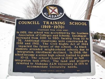
In 1919, the first building was erected nearby with funds provided locally and supplemented with a Julius Rosenwald Foundation grant. Named for William H. Councill, Alabama A&M University founder, the three-room structure was built for black . . . — — Map (db m39761) HM
On Meridian Street at Parker Drive NW, on the right when traveling north on Meridian Street.
"...A tower of knowledge, of strength, of power ...Let us build..." Dr. William Hooper Councill served as President of Alabama A&M University and was the catalyst for its early development from its founding in 1875 until his death in 1909. . . . — — Map (db m39763) HM
On Ryland Pike east of Moontown Road, on the right when traveling east.
Central High School
1917-1931
In 1916, the Superintendent of Madison County Schools met with the citizens of Ryland, Maysville, and Brownsboro to discuss plans to replace the three one-room schools serving each community. Five acres of . . . — — Map (db m113466) HM
On Ryland Pike west of Dug Hill Road, on the left when traveling west.
In October, 1808, the Western Conference of the Methodist Episcopal Church sent James Gwinn, a circuit rider, to the "great bend" of the Tennessee River to formalize existing Methodist Societies. He organized the Flint Circuit to serve frontier . . . — — Map (db m39767) HM
On Toney School Road, 0.2 miles east of Dan Crutcher Road, on the left when traveling east.
The first public county high school for African-Americans in Madison County was located in the Toney community. The original Toney School was founded in 1896 in a log cabin on the Henderson (Tump) Crutcher place (-½ mile west of this site, at the . . . — — Map (db m201346) HM
On Bee Lane (County Road 38) 0.1 miles east of County Road 63, on the right when traveling east.
Following the Civil War and emancipation, newly freed African Americans, who had worshiped in the Bethel Church in McKinley while enslaved, established their own Bethel Church in a wooden house at the rear of the current church site. In the . . . — — Map (db m72969) HM
On Jackson Street at East McCord Avenue, on the right when traveling east on Jackson Street.
The Alabama Legislature passed an act in February of 1893 calling for the construction of agricultural schools to be built in each of Alabama’s congressional districts. The city of Albertville was chosen as the site for the seventh congressional . . . — — Map (db m78709) HM
On 4th Avenue NW at 1st Street NW, on the left when traveling west on 4th Avenue NW.
First Arab High School
In the early 1900s, students from Arab enrolled at Albertville High School because Arab didn’t have a high school. One group, called the “Brindlee Mountain Boys”, would travel to Guntersville by buggy and then by train . . . — — Map (db m85850) HM
Near Cathedral Caverns Highway north of 1st Street West, on the left when traveling north.
Constructed in 1937, the Florence H. Becker Recreation Hall was named in honor of Florence Hague Becker, President General of the National Society Daughters of the American Revolution from 1935 to 1938. The vertically placed pine logs used in the . . . — — Map (db m241934) HM
On Cathedral Caverns Highway north of 1st Street West, on the left when traveling north.
In 1924, the Alabama Society of the Daughters of the American Revolution (DAR) established Kate Duncan Smith School to provide a patriotic education dedicated to academic achievement and service to "God, Home, and Country" for the people of . . . — — Map (db m33308) HM
Built as a water tower in 1937 by her husband in honor of Mrs. Harper Donelson Sheppard, Pennsylvania State Regent 1935-1938, and created a Bell Tower in 1973 upon the installation of a Carillion by the Pennsylvania Daughters in honor of Mrs. Harold . . . — — Map (db m76232) HM
On Claysville School Road, 0.1 miles east of Florida Short Route (U.S. 431), on the right when traveling east.
Claysville School was born of community pride and the tireless labor of the people. Built on five acres bought for two dollars per acre from C. W. Baird, Sarah Baird, and H. D. Walls, Claysville School was completed on February 19, 1929. Led by . . . — — Map (db m110731) HM
Near Aldock Road, 1 mile north of Whistler Road, on the right when traveling north.
The building on this site has been called many names and served many functions in its long life. Originally known as the "Methodist-Episcopalian Church" and later as the "Little Church in the Pines," the structure was located a few miles from here . . . — — Map (db m146901) HM
On Government Boulevard (U.S. 90) 0.5 miles west of Ramsey Road, on the right when traveling west.
The Grand Bay Elementary School for Colored was located on land adjacent to this building. Peter Alba donated the parcel on which the school was constructed in 1919. Soon thereafter, Black residents of Grand Bay and the Board of School . . . — — Map (db m189763) HM
On Dauphin Street at North Lawrence Street, on the left when traveling east on Dauphin Street.
Andrew N. Johnson, born 1865 in Marion, Alabama, graduated from Talladega College in 1886, and taught in rural Alabama. On this site in 1894, he established the Mobile Weekly Press, a voice for African-Americans, "A.N.", a powerful member of the . . . — — Map (db m111347) HM
On Government Street (U.S. 90) at South Lawrence Street, on the right when traveling west on Government Street.
Built 1835-1836. First public school in Alabama. Named for Rep. Willoughby Barton, author of Bill creating public schools of Mobile some 28 yrs. before State system. It was used as a hospital for Union soldiers in 1864. — — Map (db m86387) HM
Near Government Street (U.S. 90) just east of South Cedar Street, on the left when traveling east.
The first public school in Alabama built in 1835-36, used continuously since that time for the purpose of education except for a brief period during the Civil War when it was a hospital. Named for State Rep. Willoughby Barton of Mobile who was the . . . — — Map (db m143517) HM
On North Broad Street at Congress Street, on the right when traveling south on North Broad Street.
Opened in 1887 as Broad Street Academy, this was the site of Mobile's first public high school for African Americans. The building was razed in 1947, and a new elementary school was constructed and named in recognition of William Caldwell, the first . . . — — Map (db m111353) HM
On South Claiborne Street at Dauphin Street, on the right when traveling south on South Claiborne Street.
Cathedral-Basilica of the Immaculate Conception
Parish established in 1703 by John-Baptiste del la Croix, Bishop of Québec, while Mobile served as capital of Louisiana. Oldest religious congregation of any denomination in Alabama and the . . . — — Map (db m117246) HM
On Dr Martin Luther King Jr Avenue east of Ryland Street, on the right when traveling east.
Dunbar School was built on this site in 1924. Dr. W.A. Caldwell was its first principal. In 1947, the Old Medical College on St. Anthony Street was remodeled and became Central High School. Dr. Benjamin Baker was named principal. In 1955, the . . . — — Map (db m111386) HM
On Palmetto Street east of South Bayou Street, on the right when traveling east.
On this site stood Emerson Institute, Mobile's first school for the formal education of African-Americans and one of the few 19th-century normal schools for African-Americans in Alabama. Founded 1865 by the Freedmen's Bureau, the school was run by . . . — — Map (db m111289) HM
On Martin Luther King Jr. Avenue at Sengstak Street, on the right when traveling west on Martin Luther King Jr. Avenue.
Organized in 1899 as St. Anthony's Mission by Creoles of African descent. By 1901, Josephite priests Revs. Joseph St. Laurent and Louis Pastorelli had established a small school. The
present church was completed in 1908 and dedicated as Most Pure . . . — — Map (db m111302) HM
On Springhill Avenue at Knowles Street, on the right when traveling west on Springhill Avenue.
Sand Town, the oldest African American neighborhood in the area of Spring Hill, in Mobile, Alabama, was established before 1845 by former enslaved and free, indigenous people of color. Sand Town residents built their own homes, school and places of . . . — — Map (db m179993) HM
On North Dearborn Street at St Louis Street, on the right when traveling north on North Dearborn Street.
The church was organized in 1853 by ten African-Americans who were former members of Stone Street Baptist Church. It is the second oldest Missionary Baptist Church in Alabama. The first three pastors were Caucasian; however, following passage of the . . . — — Map (db m86578) HM
On Springhill Avenue at St Francis Street, on the right when traveling east on Springhill Avenue.
On this site in 1884 the Sisters of Mercy established the Convent of Mercy. In 1908 the front building, the convent, was constructed and in 1927 the adjacent school building was occupied by pupils attending Convent of Mercy Academy. The school . . . — — Map (db m86584) HM
On Bay Bridge Road (Alternate U.S. 90) at Bay Bridge Cutoff Road, on the right when traveling west on Bay Bridge Road.
Union Baptist Church
Organized in 1869 as the Old Landmark Baptist Church by Rev. Henry McCrea and the following survivors of the slave ship, Clotilda: Pollee Allen, Rose Allen, Katie Cooper, Anna Keeby, Ossa Keeby, Josephina Lee, Peter . . . — — Map (db m86299) HM
On Martin Luther King Jr. Avenue at Patton Avenue, on the right when traveling east on Martin Luther King Jr. Avenue.
Vernon Crawford established the first African-American law firm in Mobile. He successfully argued the Birdie Mae Davis case that desegregated Mobile schools. He stood before the Supreme Court and won the landmark case of Bolden vs. the City of . . . — — Map (db m111319) HM
On St. Anthony Street west of North Scott Street, on the right when traveling west.
Side 1
On May 30, 1965, Vivian Malone, became the first African-American to graduate from the University of Alabama. To achieve admission at the all-White university, she was forced to confront then Governor, George C. Wallace, in what has . . . — — Map (db m111392) HM
On Virginia Street at Wilkinson Street, on the right when traveling west on Virginia Street.
Council Traditional School was founded and opened in 1910. It is named in honor of William Hooper Councill, a former slave who was the founder of Alabama A&M University in Huntsville, Alabama. This building was erected in 1910 and underwent . . . — — Map (db m86575) HM
On U.S. 84, 1 mile west of County Road 1, on the right when traveling west.
The Perdue Hill Industrial School was founded by Patrick J. Carmichael after he moved to this area in 1918. Carmichael acted as both the principal and teacher during the early years of the school, which was originally a one-room structure serving . . . — — Map (db m47643) HM
On School Spur Road, 0.3 miles south of Pettus Road (County Road 19), on the right when traveling south.
This building was one of fourteen schools constructed in Montgomery County with funding assistance from the Julius Rosenwald Fund. Between 1912-32, Julius Rosenwald, a Jewish philanthropist and CEO of Sears, Roebuck and Company teamed up with Booker . . . — — Map (db m71427) HM
On Ash Street west of Poplar Street, on the right when traveling west.
(Side A)
Air University
The Air Corps Tactical School moved to Maxwell in 1931. Brilliant young officers like Chennault, Eaker, Fairchild, Hansell, Kuter, LeMay, Quesada, and Vandenberg formulated the aerial strategies and tactics . . . — — Map (db m64437) HM
On Maxwell Boulevard at Magnolia Drive, on the right when traveling west on Maxwell Boulevard.
Post-Vietnam Era marked a turning point for AU. Lt Gen Furlong, AU commander, launched a three year campaign to overhaul the curriculum which became known as “Putting the ‘War’ back into War College.” Between 1975 and 1976 AU gained . . . — — Map (db m64375) HM
On Twining Street north of Ash Street, on the right when traveling north.
In 1941, before Pearl Harbour, President Franklin D. Roosevelt agreed with Prime Minister Winston S. Churchill, to provide flight training for British and Commonwealth pilots in the U.S.A. by the U.S. Army Air Corps.
Over 4,000 pilots were . . . — — Map (db m64476) HM WM
The Cessna T-41 was derived from a standard Cessna Model 172 light aviation aircraft. Between 1965 and 1969 the USAF purchased 211 T-41A variants "off the shelf" for the preliminary flight screening of pilot candidates; another 52 T-41C variants . . . — — Map (db m64482) HM
On Maxwell Boulevard at Magnolia Drive, on the right when traveling west on Maxwell Boulevard.
Charged with developing doctrines and concepts for the employment of air power, AU produced the first basic doctrine manuals for the Air Force. AU also gained notoriety with projects such as Corona Harvest, which studied and developed . . . — — Map (db m64374) HM
On Maxwell Boulevard at Magnolia Drive, on the right when traveling west on Maxwell Boulevard.
To accommodate expansion of programs, a five million dollar construction project began in 1954 to give AU a modern, integrated academic center with a collegiate atmosphere and facilities in keeping with its educational mission.
We’re . . . — — Map (db m64372) HM
On Maxwell Boulevard at Magnolia Drive, on the right when traveling west on Maxwell Boulevard.
The Army Air Forces school was assigned its first commander, Major General Muir S. Fairchild, in February 1946, and renamed Air University in March. The dedication ceremony occurred 3 Sep 1946. The first classes at the Air War College and the . . . — — Map (db m64370) HM
On Maxwell Boulevard at Magnolia Drive, on the right when traveling west on Maxwell Boulevard.
During the early 1950’s, Air Force leaders decided to consolidate and relocate professional military and continuing education activities, as well as commissioning and specialized schools to Maxwell and Gunter Air Force Bases.
”(Air . . . — — Map (db m64371) HM
On Maxwell Boulevard at Magnolia Drive, on the right when traveling west on Maxwell Boulevard.
Air University began new Air War College and Air Command and Staff College programs in 1987 which met newly mandated “Joint” education requirements. These programs emphasized joint war fighting.
”The basic reason for the . . . — — Map (db m64378) HM
On Lemay Plaza, 0.1 miles south of Maxwell Boulevard, on the right when traveling south.
This facility is dedicated to the memory of Senator Lister Hill who faithfully served his state and the nation for forty-five years as a member of the House of Representatives and the United States Senate. An Infantry Officer during World War I, . . . — — Map (db m79082) HM
On Maxwell Boulevard at Magnolia Drive, on the right when traveling west on Maxwell Boulevard.
Lt. William C. Maxwell (Side A)
William Calvin Maxwell was born Nov. 9, 1892 in Natchez, Ala. An Army ROTC student at the University of Alabama, he left in 1917 to enlist in the Army. He received his commission in April 1918, after . . . — — Map (db m64367) HM
On Poplar Street at Maxwell Boulevard, on the left when traveling north on Poplar Street.
In the mid-1950s, the USAF required a trainer with higher performance than the T-33 to better prepare student pilots for the latest tactical aircraft that were then coming into service. The aircraft chosen was the T-38A which offered high . . . — — Map (db m64433) HM
On Maxwell Boulevard at Magnolia Drive, on the right when traveling west on Maxwell Boulevard.
During the late 1950’s three courses at Air Command and Staff College: the Weapons course, the Squadron Officer course, and the Academic Instructor course, became separate schools under the AU umbrella.
”…It is regrettable that what . . . — — Map (db m64373) HM
On Maxwell Boulevard at Magnolia Drive, on the right when traveling west on Maxwell Boulevard.
HQ USAF realigned AU under Air Training Command (ATC) in 1978. For five years AU remained a part of ATC. On 1 July 1983, AU regained its major command status. ROTC was reassigned to ATC. The College of Aerospace Doctrine, Research and Education, . . . — — Map (db m64376) HM
On Maxwell Boulevard at Magnolia Drive, on the right when traveling west on Maxwell Boulevard.
In 1931 Maxwell Field began its mission to educate Army Air Corps officers in strategy, tactics, and techniques of air power. Many early Air Force leaders attended Air Corps Tactical School here including Generals Vandenberg, Twining, White, and . . . — — Map (db m64369) HM
On Maxwell Boulevard at Magnolia Drive, on the right when traveling west on Maxwell Boulevard.
The tradition of excellence established by Air University pioneers will continue throughout the next fifty years… AU’s ability to educate people and develop critical thinkers is a mission that continues today. Now, more than ever, the United . . . — — Map (db m64427) HM
All discipline for the moment seems not to be joyful, but sorrowful, yet, for those who are trained by it, afterwards, it yields the peaceful fruit of righteousness.
Hebrews 4:11
Maj. Norman L. Lowry III
Capt. Willie T. Mays
Capt. . . . — — Map (db m64484) WM
On Maxwell Boulevard at Magnolia Drive, on the right when traveling west on Maxwell Boulevard.
Deja vu, once again, 1993, AU was aligned with ATC but this time to form Air Education and Training Command. Enlisted professional military education was consolidated, Officers Training School moved to Maxwell, and ROTC and CCAF were again part . . . — — Map (db m86055) HM
On Hall Street at Tatum Street, on the right when traveling south on Hall Street.
Side 1
Alabama State University
The Early Years
Founded in 1867, the Lincoln School in Marion, Alabama became the first state-assisted normal school for African Americans in 1874. The school prospered in that location for 13 . . . — — Map (db m71345) HM
Alabama State University. Founded 1866 as the Abraham Lincoln Normal School in Marion, Alabama by nine former slaves. Operated from 1868 until 1874 by the American Missionary Association. The school began to receive state funding in 1874, . . . — — Map (db m86061) HM
On Rosa L. Parks Avenue at National Street, on the right when traveling north on Rosa L. Parks Avenue.
Beulah Baptist Church was organized in the home of Monday and Dora Duvall, on the corner of Hull and Winnie Streets. Rev. William (Billy) Jenkins served as the pastor when the first church building was erected on Norton Street. Beulah served as the . . . — — Map (db m71377) HM
On Tullibody Drive at University Drive North, on the right when traveling north on Tullibody Drive.
Side 1
On Dec. 1, 1955, at Alabama State College (now Alabama State University) in a basement room in Councill Hall, the Montgomery Bus Boycott was planned and publicized after the arrest that day of Rosa Parks, who refused to give up . . . — — Map (db m91279) HM
On South Court Street at Mildred Street, on the right when traveling south on South Court Street.
Civil War-Barnes School
In April 1865, the Union Army command made this house its headquarters. Mrs. Pickett hid her silver on an inside ledge of the cupola. Later, former Confederate Generals Hood, Bragg, and Walker visited here. In 1906, . . . — — Map (db m86072) HM
On North Perry Street at Madison Avenue, on the right when traveling north on North Perry Street.
Elijah Cook
Educator, Businessman, Lawmaker
Born a slave in Wetumpka in 1833, Elijah Cook became a leader in Montgomery’s African American community. Credited with helping to establish the city’s first school for blacks in the basement . . . — — Map (db m69222) HM
Near Dexter Avenue west of North Bainbridge Street.
Emancipation
The end of the Civil War in April 1865 and ratification of the
13th Amendment to the U.S. Constitution meant the end of
enslavement for approximately four hundred thousand black
Alabamians. Freedmen embraced emancipation by . . . — — Map (db m182603) HM
On Adams Avenue at South Hull Street, on the left when traveling east on Adams Avenue.
Thomas Goode Jones, governor of Alabama from 1890-1894, occupied this house during his long political career which took him from the Montgomery City Council to a federal judgeship. During his two terms as governor, his home was the Executive Mansion . . . — — Map (db m36585) HM
Near Dexter Avenue at North Decatur Street, on the right when traveling west.
A native of Tuscumbia, he was the son of Reverend Marvin R. Heflin and Louise D. Strudwick Heflin. He was a graduate of Colbert County High School, Birmingham Southern College, and the University of Alabama School of Law. He was a past President of . . . — — Map (db m69336) HM
Near Dexter Avenue at North Decatur Street, on the right when traveling east.
A native of Notasulga in Macon County, Alabama, he was the son of Mrs. Stella Elizabeth (Burks) Livingston and Mr. James Cooper Livingston of Macon County.
Chief Justice Livingston attended the public school of Macon County and Alabama . . . — — Map (db m86123) HM
On Hall Street at Grove Street, on the right when traveling south on Hall Street.
This home was originally owned in 1901 by Emily V. Semple. It changed hands several times until purchased by Flora K. Daniels and Arlam and Johnnie R. Carr, Sr. The Carrs moved into this residence in 1943. They resided here during the 1955 . . . — — Map (db m71265) HM
On West Jeff Davis Avenue at Bragg Street, on the right when traveling east on West Jeff Davis Avenue.
Loveless School
Montgomery's first junior and senior high schools for African American students began in Loveless School. Built in 1923 and enlarged in 1930, this building first housed seven grades; the opening of Carver Elementary School and . . . — — Map (db m71082) HM
On Old Wetumpka Highway (County Road 74) at Brooks Road, on the left when traveling north on Old Wetumpka Highway.
In 1890, Elijah Madison Jr., Charles Branson, Charles Braswell and others donated funds to construct a private school in the Madison Park Community, which was founded by 14 former Slaves in 1880. A storm soon destroyed the first school building. . . . — — Map (db m142146) HM
On South Jackson Street at Tuscaloosa St. on South Jackson Street.
In 1900, Marshall Moore and his wife, Agnes V. McClain commissioned Joseph G. Nesbitt, Sr., an African-American contractor/builder, to construct this Victorian period cottage. The Moores, among the first graduates and early faculty members of . . . — — Map (db m86130) HM
Near Maxwell Boulevard just east of North Holt Street, on the right when traveling west.
The Air Force presence in Montgomery, Alabama began in April 1918 with the
establishment of the U.S. Army Air Service's Aircraft and Engine Repair Depot #3 at
the same site as the earlier Wright Brothers' flying school. On November 8, 1922,
the . . . — — Map (db m146981) HM
On Maxwell Boulevard east of North Holt Street, on the right when traveling west.
In 1910, Wilbur and Orville Wright opened a flying school on the
Kohn plantation west of Montgomery where for three months they
trained aviators and made history with the first night flight. Today,
Maxwell AFB, home of the Air University, the Air . . . — — Map (db m146978) HM
On Washington Avenue at South Perry Street, on the left when traveling west on Washington Avenue.
Montgomery County Circuit Court
Site of Major Civil Rights Cases 1956-1960
In 1956, 89 persons were indicted for violating an anti-boycott law; Rosa Parks' conviction was appealed; the Montgomery Improvement Association car . . . — — Map (db m94925) HM
On Holcombe Street at Mildred Street, on the right when traveling north on Holcombe Street.
This congregation was organized by the Court Street Methodist Church in the early 1850s. The latter group offered their 1835 wood frame building to the black members if they would relocate it. In 1852 the church was moved to this site under the . . . — — Map (db m168917) HM
Near Dexter Avenue east of South Decatur Street, on the right when traveling east.
Professor John Metcalfe Starke "Fessor Starke" 1860-1941A native of Virginia, John Metcalfe Starke received his early education in Petersburg and graduated from the University of Virginia in 1882, earning diplomas in Latin and mathematics. He . . . — — Map (db m86421) HM
Near South Court Street south of Felder Avenue, on the right when traveling south.
Established in 1910 on South McDonough Street, this school was named for the well-known southern poet, Sidney Lanier, who resided in Montgomery 1866-67.
This late Gothic Revival building was constructed 1928-29 to consolidate the original . . . — — Map (db m86424) HM
On Winona Avenue at North Florida Street, on the right when traveling west on Winona Avenue.
While Capitol Heights was a new town, city leaders, including founder and first mayor J. S. Pinckard, donated land for an elementary school. The community partnered with the Montgomery County Board of Education to build the Capitol Heights . . . — — Map (db m81810) HM
On South Union Street at High Street, on the left when traveling north on South Union Street.
This neighborhood evolved around historic First Congregational Church established through the American Missionary Association (AMA) October 6, 1872, by Pastor George Whitfield Andrews. In 1867 the AMA and the Freedmen's Bureau, headed by General . . . — — Map (db m86067) HM
On South Union Street, on the left when traveling north.
Swayne CollegeNamed for Union General and Freemen’s Bureau Agent Wager Swayne, Swayne College was dedicated 21 April 1869. The Bureau appropriated $10,000 for the building and the local black community purchased 3.5 acres for the site. Future . . . — — Map (db m28171) HM
On East Fairview Avenue at College Street, on the right when traveling east on East Fairview Avenue.
Coeducational liberal arts college of the United Methodist Church
1854: Founded as Tuskegee Female College
1872: Acquired by the Methodist Church, renamed Alabama Conference Female College
1909: Moved to this site as Woman's College . . . — — Map (db m86122) HM
On Georgia Washington Road at Antioch Lane, on the right when traveling south on Georgia Washington Road.
Miss Georgia Washington founded the Peoples Village School for black students on this site in 1893. Georgia Washington was born a slave November 23, 1851 in Virginia. As a student at Hampton Institute, Virginia, she met Dr. Booker T. Washington who . . . — — Map (db m72010) HM
On Pike Road (County Route 85) at Flinn Road, on the right when traveling south on Pike Road.
Montgomery County's first school to consolidate rural, one-room school houses into grades one through twelve opened November 11, 1918. The school was built by the Montgomery County Board of Education on 30 acres of land at a cost of $40,000 with . . . — — Map (db m72017) HM
On Federal Road (County Route 24) 0.1 miles west of Mobile Highway (U.S. 31), on the left when traveling west.
(Side 1)
Pintlala Grange Hall
The National Grange of the Patrons of Husbandry was organized in 1867 to provide economic, social and cultural improvements for farmers and their families. Pintlala's Grange Hall was erected circa . . . — — Map (db m71433) HM
On Federal Road (County Route 24) 0.3 miles Mobile Highway (U.S. 31), on the left when traveling west.
Opened in 1923 to consolidate a number of one-, two-, and three-teacher institutions in southwestern Montgomery County including Hope Hull, LeGrand, Mt. Carmel, Grange Hall, Snowdoun, Bethlehem, Fleta, Sankey, and Tabernacle. W.F. Feagin served . . . — — Map (db m71432) HM
On State Road 36, 0.1 miles east of Johnson Chapel Road, on the left when traveling east. Reported missing.
1936 Olympic Silver Medalist
Morgan County native David Donald Albritton competed at the XI Olympics in Berlin, Germany and became the first Alabama native to win an Olympic track and field medal. During Olympic Trials on July 11, 1936 at . . . — — Map (db m160716) HM
On Church Street south of 8th Avenue NE, on the right when traveling south.
When classes began on this site in the late 1800s, the teaching staff
of the East End Public School (also known as the Gibb Street School)
consisted of Professor T. A. Frierson and his wife, Anna B. Frierson.
At the time, it was the only school . . . — — Map (db m158179) HM
On Sycamore Street Northwest north of Wilson Street Northeast (U.S. 72), on the right when traveling north.
During the 1870s, Samuel Schaudies and Abbie Robinson Schaudies moved to this site from Huntsville and purchased this five-room cottage in 1881 for $800.00. The deed lists this site as part of Lot 84, “Old Town” Decatur. In 1875, their . . . — — Map (db m27763) HM
Oral tradition—stories passed from one generation to the next—long told the history of the Cherokee people. Sequoyah was the first to write it down. In 1921, about 90 miles east of Decatur, he created the Cherokee syllabary, a set of 85 . . . — — Map (db m140861) HM
On Bibb Street at Early Street, on the right when traveling north on Bibb Street.
Founded 1838
Milo P. Jewett, President
Deeded in 1843 to
The Alabama Baptist Convention
One of the nation's first colleges to offer higher education for women, it has served, since its founding, as a liberal and fine arts . . . — — Map (db m70071) HM
On Lincoln Street at Lee Street, on the left when traveling west on Lincoln Street.
On July 17, 1867, nine ex-slaves (James Childs, Alexander H. Curtis, Nicholas Dale, John Freeman, David Harris, Thomas Lee, Nathan Levert, Ivey Pharish and Thomas Speed) formed and incorporated the “Lincoln School of Marion.” They soon . . . — — Map (db m70096) HM
On Jefferson Street at Pickens Street, on the right when traveling east on Jefferson Street.
County Seat of Perry County
Population 4457
Founded by Anderson West in 1822
Home of Judson College
and
Marion Military Institute
Friendly People Welcome You. — — Map (db m116895) HM
On Washington Street, 0.1 miles north of Grove Street, on the left when traveling north.
Founded in 1842 as Howard English & Classical School by the Alabama Baptist Convention, with Dr. S. S. Sherman as President, it later became Howard College. Lovelace Hall (Old South Barracks), built 1854, and the Chapel, built 1857, served the . . . — — Map (db m70091) HM
On West Monroe Street at Spring Street, on the left when traveling east on West Monroe Street.
One of the earliest colleges for women in America. Founded in 1835, was the first of four colleges established in Marion,“The Athens of Alabama.”
This building, erected in 1850, contained the art studio of Nicola Marschall, who . . . — — Map (db m70068) HM
Near Columbus Road (Alabama Route 14) at 10th Avenue Northwest, on the right when traveling north.
Summerville Industrial High School, the first high school for African Americans in the southern part of Pickens County, was moved to this site in 1958, becoming Robert Jackson Kirksey High School. The new name honored a long-term member of the . . . — — Map (db m92647) HM
On Jim Locke Road at Copper Road, on the left when traveling east on Jim Locke Road.
This school was erected in c. 1925 and sits on 3 acres donated by two community citizens, Nunnie and Jennie Stinson, parents of Yeuma Stinson-Gillis.
Some educators were: A.B. Bonner, Nora Spencer, Dotha Will Moss, Annie Sherrod, Zora . . . — — Map (db m178783) HM
On County Road 2203 south of County Road 2204, on the left when traveling south.
Built ca. 1860 on land owned by Daniel Carlisle, this school educated Pike County youths until consolidation closed its doors in 1935. In 1895 it was conveyed to trustees for the school by Robert Henry Lee Rodgers for a school. Between 1923 and . . . — — Map (db m92684) HM
On Lockheed Martin Drive (County Route 37) at Old U.S. Highway 231 (County Route 105), on the left when traveling east on Lockheed Martin Drive.
Founded 1848 by legislative act and donations of citizens. Excellent instruction made it only school of kind for youth in area. Later used as public school until 1929 school consolidation.
Orion settled about 1815, by 1830 saw arrival of . . . — — Map (db m71791) HM
On University Avenue west of Luther Drive, on the right when traveling east.
Donated to Troy University by Huo Bao Zhu During the visit of Chancellor Jack Hawkins, Jr. to Xian, China in April 2002.
The gift was made in celebration of the Sino-American 1-2-1 Joint Degree Program and as a lasting symbol of friendship between . . . — — Map (db m38930) HM
On East Academy Street at Farrior Street, on the left when traveling east on East Academy Street.
Side 1
On May 9, 1921, S.B. Innis, C.L. Jenkins, James Henderson, Pres Thomas and C.B. Brooks, the “colored school committee,” entered into a school mortgage for the construction of a building for “colored school . . . — — Map (db m76755) HM
Built in 1929, Bibb Graves Hall opened in September, 1930. It was named for Alabama Governor Bibb Graves (1927-31, 1935-39) who was known as the “education governor.” Bibb Graves Hall served as the original administration building for . . . — — Map (db m38940) HM
On McKinley Drive north of University Avenue, on the left when traveling north.
Built in 1961 and renovated in 1989, the Chancellor's residence is the "front door" to the University. It has served as the entertainment site for international, national, state and local leaders, including ambassadors, U.S. Senators, governors, . . . — — Map (db m111582) HM
Named for Fletcher Thomas Cowart, a Troy University professor of natural science from 1890 to 1919. Cowart Hall was constructed in 1950. Originally a men’s dormitory, it was later used to house junior and senior women students. The structure was . . . — — Map (db m38933) HM
Born in Henderson, Alabama in 1850, Fletcher Jackson Cowart began his working career as a public school teacher. He later served superintendencies for both the Pike County and the Troy City schools. He was editor of the Troy Messenger and a . . . — — Map (db m38934) HM
On University Avenue west of South George Wallace Drive, on the left when traveling west.
“Tailgating" on the Troy campus was initiated during the 1990’s through the example and leadership of Green Davis. In 1993 the area outside of Memorial Stadium was named in honor of Green Davis for his enduring efforts to boost Trojan . . . — — Map (db m38929) HM
Near Luther Drive, 0.1 miles north of University Avenue, on the left when traveling north.
Janice Hawkins Park was named in honor of the First Lady of Troy University, a devoted wife and loving mother, whose work benefited Troy in the fine arts, service to students, internationalization of the University, and support of military veterans. . . . — — Map (db m111581) HM
Near University Avenue, on the right when traveling west.
Built in 1929 and originally named for Gov. Bibb Graves,
this building was renamed in 2020 in memory of U.S. Rep.
Lewis, a central figure in the U.S. civil rights movement.
Nicknamed "the boy from Troy" by Dr. Martin Luther King,
Jr., he was the . . . — — Map (db m168100) HM
15240 entries matched your criteria. Entries 301 through 400 are listed above. ⊲ Previous 100 — Next 100 ⊳