Near Luther Drive, 0.1 miles north of University Avenue, on the left when traveling north.
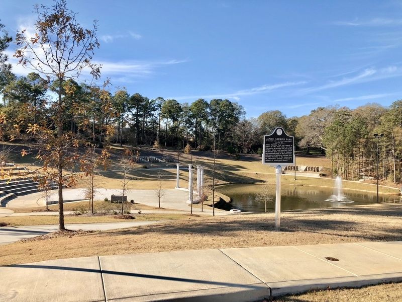
Janice Hawkins Park was named in honor of the First Lady of Troy University, a devoted wife and loving mother, whose work benefited Troy in the fine arts, service to students, internationalization of the University, and support of military veterans. . . . — — Map (db m111581) HM
Near University Avenue, on the right when traveling west.
Built in 1929 and originally named for Gov. Bibb Graves,
this building was renamed in 2020 in memory of U.S. Rep.
Lewis, a central figure in the U.S. civil rights movement.
Nicknamed "the boy from Troy" by Dr. Martin Luther King,
Jr., he was the . . . — — Map (db m168100) HM
The original structure was named for Charles Roderick McCall, Professor of Languages at Troy Normal School from 1890 to 1898. It was constructed in 1960-1961 to house the various sciences. In 1999, the structure was renovated and enlarged to house . . . — — Map (db m38938) HM
Built in 1946 as a men’s dorm. Named for Matthew Downer Pace, who served Troy University from 1891 to 1941 as Professor of Mathematics, Dean and President. The building was made necessary by the heavy influx of male students enrolling immediately . . . — — Map (db m38931) HM
On Luther Drive north of University Avenue, on the right when traveling north.
Originally constructed as the home field for the university’s football and baseball teams. Pace Field, home of the Troy Trojans and the Troy baseball team in the late 1930s and 1940s, stood at the location of the current Riddle - Pace Field. It is . . . — — Map (db m38935) HM
On University Avenue at Luther Drive, on the right when traveling west on University Avenue.
Rushing Hall was named in honor of distinguished Class of 1965 Troy Alumni, Sue and Lewis Rushing, of Birmingham, Alabama by the Troy University Board of Trustees on February 22, 2018. It was named in recognition of the Rushings' loyalty to Troy . . . — — Map (db m205227) HM
Built during 1929, Shackelford Hall opened to students in September 1930. It was named for the institution’s president Edward Madison Shackelford, who served from 1899 to 1936. Adjoining this building was the original dining facility for the campus. . . . — — Map (db m38932) HM
On University Avenue west of Luther Drive, on the left when traveling west.
Troy State Normal School was established by the Alabama General Assembly in 1887. Land and the first building for the original downtown campus and land for the present site were provided by the City of Troy. The College was moved to the present site . . . — — Map (db m38937) HM
On Lafayette Highway, 0.1 miles north of West Point Street, on the right when traveling north.
Randolph County Training School (RCTS) was chartered on
September 15, 1919 as a public school for African Americans. It
opened in the fall of 1920 with 73 students. The original two-story
wood structure was built with contributions from black . . . — — Map (db m235575) HM
In September 1821 Rev. William Capers was sent to Fort Mitchell, by the South Carolina Conference of the Methodist Episcopal Church, to negotiate with the chiefs of the Creek Indian Nations for a mission which would teach their children reading, . . . — — Map (db m26121) HM
On Old Seale Highway (County Road 137) 0.3 miles north of Penny Well Road, on the left when traveling north. Reported missing.
One of the earliest white settlements in the Old Creek Indian Nation. James Elizabeth Glenn, who named the town, and his brother Thompson Glenn, arrived here in 1835 only to have to evacuate during the Indian uprisings of 1836, at which time all . . . — — Map (db m248631) HM
On 5th Avenue at 15th Street, on the left when traveling north on 5th Avenue.
(side 1)
Born at New Site, Alabama, he grew up working on his parents’ farm. In 1916 he worked in the oil fields in Texas and joined the Texas National Guard. He married Agnes Benson of Alabama in 1917. In 1918 he was commissioned an . . . — — Map (db m69114) HM
On 11th Avenue just north of 15th Street, on the right when traveling north.
In 1953 the Phenix City Elementary School for Negroes was constructed during the tenure of L.P. Stough, Phenix City School Superintendent. It was built to accommodate 488 students with 13 classrooms, a multi-purpose room, clinic, library, cafeteria . . . — — Map (db m173475) HM
Near Old Seale Highway (U.S. 431) 0.6 miles south of Villula Road (County Road 58), on the left when traveling south.
Originally known as Vilula, this community was formed about 1848 as a stage coach stop. For many years the only post office in the central part of the county was located here. William A. Lester served as the first postmaster. The Villula . . . — — Map (db m188837) HM
On Oswichee Road (County Road 18) 1.9 miles east of Greenburt/Nuckols Roads (County Road 39), on the right when traveling east.
Macedonia Missionary Baptist Church
Macedonia Baptist Church was organized in 1870 by Pastor Robert Fegins with the assistance of twelve members from Providence Baptist Church. The first person baptized in the church was Mr. Charles Smith . . . — — Map (db m78113) HM
On State Road 25 at County Road 23, on the right when traveling east on State Road 25.
Side 1
James Hardy and his twin brother, Julian, were born and reared in Newala, Alabama, 3 miles east of Montevallo. He attended the consolidated grammar school nearby which had 3 rooms for the 6 grades, then attended high school in . . . — — Map (db m76244) HM
Known as the Alabama College Laboratory School, Montevallo High School was housed in Reynolds’ Hall on the University of Montevallo campus from 1922 until January 1930 when the central portion of this building was completed. The original structure . . . — — Map (db m37428) HM
On Highland Street south of Bloch Street, on the left when traveling north.
Originally named Alabama Girls' Industrial School and later Alabama College, this institution was founded Oct. 12, 1896, by the Alabama Legislature. It was the state college for women until 1956, when it became coeducational. In 1969 the name was . . . — — Map (db m37289) HM
On 8th Street, 0.1 miles south of 8th Avenue, on the right when traveling north.
This park was dedicated on May 15, 1990 to D. O. Langston for his service to the town of Ashville, his support for senior citizens, and his enduring impact on our community.
A native of Oakvale, Mississippi, Mr. Langston was born in 1904 and died . . . — — Map (db m156372) HM
On 5th Street (U.S. 411) at 7th Avenue, on the right when traveling south on 5th Street.
Greek revival antebellum home built by Moses Dean in 1852, acquired by John W. Inzer in 1866. Home occupied by Inzer family from 1866 to 1987. In July 1987 home and its contents, including extensive law library, deeded by family heirs to St. Clair . . . — — Map (db m28092) HM
On Liberty Road at U.S. 411, on the right when traveling west on Liberty Road.
Liberty Cumberland Presbyterian Church was organized on this site in March, 1835. However, the congregation probably met here as early as 1821, when Rev. Peter Harden and other Presbyterians first settled in the valley. The present church building . . . — — Map (db m217728) HM
On North Washington Street (U.S. 11) just north of North Street, on the left when traveling north.
Former site of the Houston-Bailey House, built ca. 1835 as a residence by Matthew C. Houston, a founding citizen and early merchant of Livingston. The home was visited by his cousin, Sam Houston, in 1845. Later residents included Adolph Brown, who . . . — — Map (db m228699) HM
On North Washington Street (State Highway 11), on the left when traveling north.
Chartered in 1840 as Livingston Collegiate Institute (1835: Female Presbyterian Academy planned). In 1883, by work of Julia Tutwiler, Alabama legislature made its first grant of funds to a girls school. In 1907: State Normal school. In 1929: became . . . — — Map (db m109526) HM
On South Street East (State Highway 77) at East Street South, on the right when traveling east on South Street East.
By action of the Alabama Conference of The Methodist Episcopal Church, South in session at Talladega, December 13-18, 1854, Auburn University and Birmingham - Southern College were born. The delegation resolved to “have a college within the . . . — — Map (db m28202) HM
On Ashland Highway (State Highway 77) east of Chaffee Street, on the right when traveling east.
Originally conceived 1864 as a home for children of Confederate dead by Synod in session at Selma.
Opened at Tuskegee 1868 - relocated in Talladega 1891. A haven for dependent youth of Alabama providing training, education, and worship in a . . . — — Map (db m28206) HM
On Brignola St, 0.2 miles east of N East st (Alabama Highway 77).
The distinguished Joiner family lived here in an imposing mansion, demolished in 1970.
James H. Joiner: Pioneer in Talladega's progress while publisher, 1844-73, of one of Alabama's most influential newspapers - The Democratic Watchtower. . . . — — Map (db m37220) HM
On Senator Claude Pepper Drive (Alabama Route 50) at Newell Street, on the left when traveling west on Senator Claude Pepper Drive.
(side 1)
Edward Bell High School
On this site Tallapoosa County Training School, later named Edward Bell High School, became the first high school for African Americans in Tallapoosa County, Alabama in 1931, with graduation of its . . . — — Map (db m92505) HM
On Pittman Avenue (State Highway 50) at Ward Circle, on the right when traveling west on Pittman Avenue.
Lyman Ward Military Academy was founded in 1898 as the Southern Industrial Institute by Dr. Lyman Ward, a Universalist minister from New York. Dr. Ward established SII to educate the poor children of Alabama, many of whom had few opportunities due . . . — — Map (db m25501) HM
On South Broadnax Street at Eufalla Street, on the right when traveling south on South Broadnax Street.
Fletcher Farrington, after graduating from the Alabama Polytechnic Institute (now Auburn University), came to Tallapoosa County as a county agent for the Agricultural Extension Service in 1932. Concluding that soil erosion was the local farmers . . . — — Map (db m95105) HM
On North Broadnax Street at West Lafayett Street, on the right when traveling south on North Broadnax Street.
Alabama’s first medical school.
Trained physicians who
rendered great service to
the State and Confederacy.
Closed by war
and death of its founder,
Philip M. Shepard, M.D. — — Map (db m28741) HM
On East Lafayette Street east of North Spring Street, on the left when traveling east.
A 1907 act of the Alabama Legislature called for the
construction of a new public high school in each
county. Officials selected Dadeville as the location of
Tallapoosa County High School. Residents sought
private funds and used a bond issue to . . . — — Map (db m223975) HM
On Alabama Route 22 east of Drake Road, on the right when traveling east.
Daviston, Alabama
Daviston, incorporated February 16, 1887, is believed to be the first incorporated rural town in Tallapoosa County. The first mayor was J.D. Dunn. Daviston was a natural evolution of the opening of Indian lands in 1832. Much . . . — — Map (db m92502) HM
Near Confederate Parkway, 0.4 miles south of Tannehill Road, on the left when traveling south.
Successor to the first school built in Jefferson County in 1815, this building - of 1923 origins - served the residents of the Beltona Area until 1960. Purchased in 1963 by the Cane Creek Community Club, it was subsequently donated to Tannerhill . . . — — Map (db m107503) HM
Near Confederate Parkway south of Tannehill Road, on the left when traveling south.
Built near West Blocton, Al in 1860 by Winston Stewart, a local contractor. Mr. and Mrs. Fowler occupied the house from 1928 until their death.
Restored as a country School to be a part of the Learning Center in 1978...
Donated by the . . . — — Map (db m107995) HM
After the seat of government was moved to Montgomery in 1847, the Tuscaloosa Capitol and its furnishings were deeded to the University of Alabama to be used for educational purposes.
In 1857, the University Board of Trustees leased the building . . . — — Map (db m29064) HM
On Magnolia Drive north of Paul W. Bryant Drive, on the right when traveling north.
Alpha Delta Pi, the first college secret sisterhood, was organized at Wesleyan Female College, Macon, Georgia, the first women's college to grant academic degrees. Originally identified as Adelpheans, the group had three thousand alumnae and sixty . . . — — Map (db m28783) HM
Daughter of John Gayle, Governor of Alabama.
Wife of Josiah Gorgas, Brigadier General, C. S. A.
Mother of William Crawford Gorgas, Surgeon General, U. S. A.
Untiring nurse in Confederate Hospitals, 1861-1865.
First Historian Alabama Division, . . . — — Map (db m33653) HM
On University Boulevard at Colonial Drive, on the right when traveling west on University Boulevard.
First African American to enroll at the University of Alabama following successful litigation under the historic 1954 Brown v. Board of Education ruling. She began classes on February 3, 1956; however, after three days of tumultuous demonstrations, . . . — — Map (db m108342) HM
Named for Braxton Bragg Comer (1848-1927), Governor of Alabama (1907-1911).
As a member of the University's Corp of Cadets in 1865, Comer witnessed the burning of the campus by Federal troops. Later, as Governor, he strongly supported education . . . — — Map (db m29121) HM
On Paul W Bryant Drive east of 2nd Avenue, on the left when traveling east.
In 1883 the Castle Hill Real Estate and Manufacturing Company began the first eastern expansion of the original 1821 Tuscaloosa city limits. Hoping to stimulate development in the area, the company created a popular amusement park centered around . . . — — Map (db m35467) HM
On Hackberry Lane at Devotie Drive, on the right when traveling south on Hackberry Lane.
Centennial of Women 1893 - 1993
In 1892 Julia Strudwick Tutwiler petitioned the Board of Trustees of the University of Alabama to accept female students into the all-male student body. Admitted in 1893, Anna Adams and Bessie Parker became the . . . — — Map (db m235773) HM
On Lurleen B Wallace Boulevard North (U.S. 43) at 6th Street, on the right when traveling north on Lurleen B Wallace Boulevard North.
The second oldest Episcopal Church in Alabama. Construction begun 1829, completed 1830 at cost of $1700. Enlarged and remodeled in 1880 from original Greek Revival design to present Gothic lines. First pews sold to highest bidder; made free in 1849. . . . — — Map (db m40419) HM
On University Boulevard at Stadium Drive, on the right when traveling west on University Boulevard.
marker Front: Psi Chapter of Delta Kappa Epsilon fraternity first Greek letter fraternity at The University of Alabama. Organized by Louis J. DuPre, chapter installed June 20, 1847. First members initiated at Indian Queen Hotel by Charles . . . — — Map (db m30676) HM
Near University Boulevard west of 6th Avenue, on the right when traveling west.
This bell tower, an enduring symbol of Alabama's first university, was erected in honor of President George H. Denny, under whose leadership (1911 to 1936) The University of Alabama gained national prominence. Conceived by Jerome M. Britchey and . . . — — Map (db m29610) HM
On Hackberry Lane at 4th Street, on the left when traveling south on Hackberry Lane.
Constructed in 1923 through gift of J. T. Horne, this building occupied by Druid City Hospital School of Nursing from 1923 to 1947. Used by University of Alabama from 1951 to 1954 to house first state supported collegiate school of nursing in . . . — — Map (db m29608) HM
On Greensboro Avenue at Stillman Blvd, on the right when traveling south on Greensboro Avenue.
Organized 1820.
Moved to this site 1830.
Present structure erected 1921.
Under the leadership of Dr. Charles A. Stillman, (Minister, 1869-1895) it sponsored the founding of Stillman College in 1876. Its bell was the subject of a poem by . . . — — Map (db m35364) HM
During his term our state moved from frontier to urbanity. The University of Alabama was officially opened. Construction was begun on our first canals and railroads, supplementing existing steamboats and unpaved roads. The Choctaws exchanged their . . . — — Map (db m29023) HM
On Capstone Drive at Colonial Drive, on the right when traveling west on Capstone Drive.
Built 1829 as University dining hall.
Remodeled as a residence 1840.
Occupied by Gorgas family 1879-1953
(Reverse):
Preserved as a memorial to:
General Josiah Gorgas (1818-1883)
Chief of Ordnance, C. S. A. 1861-1865 . . . — — Map (db m29301) HM
On Cherokee Road, 0.4 miles south of Loop Road, on the right when traveling south.
Dr. Hudson Strode (1892-1976) – author, scholar, teacher and world traveler – and his beloved wife, Therese (1900-1986) lived here from 1941 until their deaths. Professor of English at the University of Alabama (1916-1961): he was renowned for his . . . — — Map (db m203509) HM
On Magnolia Drive at Sorority Circle, on the right when traveling north on Magnolia Drive.
Zeta Chapter of Kappa Delta first national Greek letter sorority at the University of Alabama Chapter installed March 12, 1904. First members initiated in the Sigma Nu Hall by Katherine Lovejoy of Theta Chapter at Randolph-Macon Woman's College. . . . — — Map (db m28782) HM
On 6th Avenue at 8th Street, on the right when traveling north on 6th Avenue.
The Autherine Lucy Clock Tower is dedicated to the sacrifice and commitment of a courageous individual who took a stand for change at a crucial time in the history of The University of Alabama. The open arches, which mirror the architecture of . . . — — Map (db m37918) HM
On Stadium Drive north of University Blvd, on the left when traveling north.
Here, on the highest point of the original campus, stands the first celestial observatory at The University of Alabama and one of the oldest observatory buildings in the United States. Through the efforts of Professor F. A. P. Barnard, the first . . . — — Map (db m34842) HM
Named for John Tyler Morgan (1824-1907).
As U.S. Senator, Morgan led the 1882 campaign to obtain federal funds in reparation for the destruction of the University of Alabama campus by Union Troops in 1865.
A member of the Alabama Secession . . . — — Map (db m29223) HM
Erected: 1889
Reconstructed: 2000
Named for professor, scientist, and photographer F.A.P. Barnard who pioneered the study of astronomy at The University of Alabama and established its chapter of Phi Beta Kappa in 1851.
On August 26, 2000, . . . — — Map (db m29402) HM
On University Boulevard, 0.1 miles west of Stadium Drive, on the right when traveling west.
On this site in 1914, Theta Chapter of Phi Gamma Delta built the first Chapter House located on the campus of the University of Alabama. The house was the first structure on what became known as Fraternity Row, later known as "Old Row." That house, . . . — — Map (db m156516) HM
The Rotunda Plaza is dedicated to
John H. and Carolyn Cobb Josey
(Classes of 1950 and 1951, respectively)
In recognition of the establishment in 1992 of the John H. and Carolyn Cobb Josey Library Endowment Fund, ensuring continued . . . — — Map (db m30678) HM
On University Boulevard at 5th Avenue, on the right when traveling west on University Boulevard.
Founded in Tuscaloosa on the campus of the University of Alabama on March 9, 1856. Its chapter designation, Alabama Mu, identifies it as the mother chapter of the national collegiate fraternity.
Founding Members:
Noble Leslie DeVotie •
Nathan . . . — — Map (db m29607) HM
Franklin Hall, an early University dormitory designed by Capt. William Nichols, was erected on this site in 1835. Was one of the buildings destroyed by the Union raid on April 4, 1865. After Civil War the remains of structure were shaped into . . . — — Map (db m30677) HM
Foster Auditorium is the site of the June 11, 1963, “stand in the schoolhouse door” by Governor George C. Wallace in defiance of a court order requiring The University of Alabama to admit African-American students Vivian Malone and James . . . — — Map (db m37917) HM
On 6th Avenue at Capstone Drive, on the right when traveling north on 6th Avenue.
Named for Eugene Allen Smith (1841-1927), University Professor and State Geologist, who served the State in this dual capacity for fifty-four years.
Smith rebuilt the collections of the Alabama Museum of Natural History, which had been . . . — — Map (db m29403) HM
On Stillman Boulevard, on the right when traveling east.
Founded as Tuscaloosa Institute 1876 by Presbyterian Church U.S. under leadership of Dr. Charles Allen Stillman, pastor of First Presbyterian Church, Tuscaloosa, to train Black ministers. Renamed Stillman Institute 1894 for Dr. Stillman, first . . . — — Map (db m35676) HM
The Capitol in Tuscaloosa was designed by English-born architect, William Nichols, who served as State Architect from 1826 - 1832. Nichols also designed and built the campus of The University of Alabama.
Before coming to Alabama he had . . . — — Map (db m29117) HM
On 23rd Avenue at 17th Street when traveling south on 23rd Avenue.
Built in 1837 by skilled slave craftsmen, the Drish Mansion is notable for its unusual combination of Greek Revival and Italianate architecture. John Drish, a physician and contractor, assisted with building Bryce Hospital, old state capitol, and . . . — — Map (db m217201) HM
On Stadiium Drive at McCorvey Drive, on the right when traveling east on Stadiium Drive.
includes
The Gorgas House (1829)
First structure built on the original campus
The Round House (1860)
Used by cadets on guard duty, and another of the four buildings to survive the fires set by Federal troops in 1865.
Woods Hall . . . — — Map (db m29396) HM
On Capstone Drive, on the right when traveling east.
Constructed as a guard house for the Alabama Corps of Cadets during the early 1860's, the Little Round House provided shelter from inclement weather for cadets on sentry duty. Until 1865, it also housed the University Drum Corps, which was composed . . . — — Map (db m25387) HM
On University Boulevard, on the right when traveling east.
In 1838 The University of Alabama Board of Trustees appropriated funds for a more suitable residence for the University's new president Basil Manly. The mansion on this site was built between 1839 and 1841 from plans provided by Michael Barry who . . . — — Map (db m25414) HM
On Paul W. Bryant Drive east of 2nd Avenue, on the right when traveling east.
Founded in 1872 as the first law school in Alabama. Henderson M. Somerville was the first professor and later an Alabama Supreme Court Justice. The first dean was William L. Thorington (1897-1908). The school occupied, in turn, parts of Woods, . . . — — Map (db m35471) HM
Designed by Montgomery architect W. A. Crossland and named for noted professor and state geologist Michael Tuomey.
Tuomey's survey resulted in the landmark 1849 geological map of Alabama and his work began the Geological Survey of Alabama. . . . — — Map (db m29400) HM
On University Blvd. at Queen City Avenue, on the right on University Blvd..
Built 1834 by James Dearing. Purchased by Arthur P. Bagby who occupied the house 1837-41 while Governor of Alabama and since known as the Governor's Mansion. Presented to the University of Alabama 1944 by Herbert David Warner and Mildred Westervelt . . . — — Map (db m29120) HM
Near University Boulevard west of 6th Avenue, on the right when traveling west.
Endowed by Congress 1819
Ordained by State constitution 1819
And established by General Assembly 1820
Instruction Begun 1831
Unofficial Training School Confederate Officers 1861-65
Destroyed by Federal Army April 4, 1865, Rebuilding Begun . . . — — Map (db m29612) HM
The University of Alabama gave to the Confederacy - 7 General Officers, 25 Colonels, 14 Lieutenant - Colonels, 21 Majors, 125 Captains, 273 Staff and other commissioned officers, 66 Non-Commissioned Officers and 294 Private Soldiers. Recognizing . . . — — Map (db m33654) HM
On Hackberry Lane at Margaret Drive, on the right when traveling north on Hackberry Lane.
Buried near this plaque are Jack Rudolph and William “Boysey” Brown, two slaves owned by University of Alabama faculty, and William J. Crawford, a University student who died in 1844.
Rudolph was born in Africa about 1791 and died . . . — — Map (db m40389) HM
Near 7th Avenue near McCorvey Drive and Stadium Drive.
Named for Alva Woods (1794-1887), First President of the University of Alabama, 1831-1837.
Constructed after the Civil War, this gothic revival structure was built of materials salvaged from the original campus, burned by Federal Troops in . . . — — Map (db m29221) HM
On Magnolia Drive at Paul W Bryant Drive, on the left when traveling north on Magnolia Drive.
Nu chapter of Zeta Tau Alpha was installed as the second sorority at the University of Alabama. On April 11, 1910 the chapter's first nine women were initiated in the Sigma Nu hall. In 1925, Zeta Tau Alpha built the first sorority house on the . . . — — Map (db m235502) HM
On Prestwick Road, 0.5 miles west of Johnson Road, on the right when traveling west.
Prestwick Post Office
The Prestwick Post Office was established on
February 24, 1904, with Alice Speadham as
postmaster. It was discontinued temporarily on
October 31, 1923. After it was reestablished in
March 1927, Walter B. Taylor held . . . — — Map (db m244903) HM
On Claiborne Street (Alabama Route 28/41) 0.2 miles west of Firehouse Road, on the right when traveling west.
[side 1 • faces east] In 1886, William Henderson, a Scottish immigrant, former Union Army Officer, and United Presbyterian moved from New York to Wilcox County. He saw the plight of freed slaves and urged his children to begin schools in the . . . — — Map (db m228693) HM
On North Broad Street (Alabama Route 28) at Fail Street, on the left when traveling north on North Broad Street.
Incorporated 1850 by James A. Tait, L. W. Mason, Joseph George and Associates
Original Trustees: Col. J. C. Jones, Joseph George, Maj. M. M. Bonham, D. W. Sterrett, Col. C. C. Sellers, Dr. M. Reid, J. W. Bridges, Dr. Robert Irvin, and Maj. F. . . . — — Map (db m68156) HM
On State Highway 28 at McCall Road (Prairie Mission Road), on the right when traveling west on State Highway 28.
Prairie Mission was established in 1894 by the Freedmen’s Board of the United Presbyterian Church of North America to educate the children of ex-slaves. The Mission consisted of a church, school building, dormitories for male and female students, a . . . — — Map (db m38496) HM
On State Highway 10 at Adams Street on State Highway 10.
Founded in 1882 by John Trotwood Moore, who became a famous author, archeologist, and poet laureate of the State of Tennessee, the original two-story wood frame building served the Pine Apple area from 1882 until the present brick structure was . . . — — Map (db m47705) HM
On Snow Hill Institute Road, 0.3 miles north of County Road 26, on the right when traveling north.
(obverse)
Snow Hill Institute was founded in 1893 by William James Edwards, a graduate of historic Tuskegee Institute established by Booker T. Washington in 1881.
Snow Hill’s lineage extends back to Hampton Institute where Washington . . . — — Map (db m68185) HM
On Wilson Bend Road (County Route 12) north of County Route 242, on the left when traveling north.
The Community’s first four settlers homesteaded land near this site in 1832. The little log schoolhouse, just 18 feet square, was built in 1874. The land, given by L. F. Hembree, is now the site of Bethel Cemetery. With no heat, a dirt floor, and . . . — — Map (db m42861) HM
On County Road 41 south of County Road 3815, on the left when traveling south.
Named for Uncle Harve Smith, patriarch of the Smith Family in this community. Built in 1911 on two acres of land bought for $5.00. Seat of learning of readin' 'ritin', and 'rithmetic until 1923 when it was consolidated with others to form Meek . . . — — Map (db m201369) HM
On County Road 41 north of Nathan Loop Road (County Road 1285), on the left when traveling north.
Meek School was erected on ten acres of land given by Mr. and Mrs. J.E. Wadsworth. Chiefly through the efforts of Warren Hamner and Claude Miller, Meek School become the first consolidated school in Winston County. In the Spring of 1923, Nathan . . . — — Map (db m201368) HM
On Helicon Road (County Route 77) at Nathan Loop Raod (County Route 1285), on the right when traveling west on Helicon Road.
Post office established May 9, 1908. Named for the first postmaster, Nathan B. Langley, who was succeeded by Robert C. Walker and David H. Hamner. Post office discontinued June 30, 1915; housed in a general store operated on this site by
Warren . . . — — Map (db m42860) HM
On County Route 41 south of Mellville Road, on the right when traveling north.
Only two-room schoolhouse for miles around. Built in 1903, “The Big Room” was a two-story building with the Masons using the upper story. “The Little Room” was a later addition. The basic studies were the three R’s and The . . . — — Map (db m42856) HM
On County Route 41 at County Route 275, on the right when traveling north on County Route 41.
Originally known as Dismal School. Built of pine logs in 1900 on 1½ acres of land given by Zeb Humphreys, the building was about 20 feet square. Seats were rough board benches without backs. Students gathered pine knots to burn in the heating . . . — — Map (db m42862) HM
On Alabama Route 195 at County Road 327, on the right when traveling south on State Route 195.
Founded in 1880 by Robert Gold Isbell, President, alumnus of Vanderbilt University, under the jurisdiction of the North Alabama Methodist Conference, one mile west on the Cheatham Road at the town of Motes. Elijah Blanton, Hugh W. Isbell, W.R. . . . — — Map (db m153248) HM
On County Road 63 at County Road 61, on the left when traveling south on County Road 63.
As the 15th Governor of Alabama, Winston signed the bill creating the Alabama Public School System in 1854. He was known as the "Veto Governor” due to his stance against transportation funding. In his honor, Hancock County's name was changed to . . . — — Map (db m182870) HM
On Cushman Street at 4th Avenue on Cushman Street.
In the winter of 1904, the first Fairbanks Public School was opened. Ten students finished the spring term. In the fall of 1905, the school enrolled 50 students. The next year, 150 students attended.
Construction of a much-needed new school on the . . . — — Map (db m219204) HM
On Cushman Street, on the left when traveling north.
In November of 1907, a two-story wooden schoolhouse with a cupola was completed on this site. Over time, to accommodate growth, the schoolhouse was expanded and additions were made. In 1932, the school was destroyed by fire, but rebuit in 1934 as . . . — — Map (db m238727) HM
On Calhoun Avenue north of West 4th Street, on the left when traveling north.
Built by the Civilian Conservation Corps — 1935
Olaf Torkelson, Juneau Street Commissioner from 1924-1936, was instrumental in the success of this project. The overpass was built to provide safe access for children who attended Capital School . . . — — Map (db m181738) HM
Near Mill Street east of Bawden Street, on the left when traveling east.
The Christian cross was planted in Ketchikan's shoreline in 1897, when the settlement was only a creekside collection of Native homes and a trading site for the first white businessman in the area. The missionary priest who staked an ecclesiastical . . . — — Map (db m182004) HM
On Lincoln Street at Monastery Street, on the right when traveling west on Lincoln Street.
has been designated a
Registered National
Historic Landmark
under the provisions of the
Historic Sites Act of August 21, 1935
This site possesses exceptional value
in commemorating and illustrating
the history of the United . . . — — Map (db m181596) HM
On West 26 Bar Road, 0.4 miles west of School Bus Road, on the right when traveling west.
This stone chimney is all that remains of a one room country school house that served pioneer Amity pop. 119 from the early 1880's until closing in April 1930. The Amity Cemetery & Amity Ditch are the only other remains of this early Mormon . . . — — Map (db m36614) HM
On Main Street at West 2nd Street, on the left when traveling north on Main Street.
After the original frame school house burned in 1930, this building served Eagar's children for 53 years. Mothers prepared hot lunch across the street creating Eagar's own depression era "soup lines" at 5 cents a cup for the children. — — Map (db m36628) HM
On East Main Street, 0.2 miles east of South Mountain Avenue, on the right when traveling east.
This bronze school bell summoned children until 1950. This 2 room adobe with high pitched roof & bell tower was added onto with brick, altering the entry & roof in 1927 & again in 1950. The school served the community 99 years. — — Map (db m36653) HM
On Lehner Road, 2 miles north of Palominas Road & State Highway 92, on the left when traveling east.
At this location in 1952, a large bone bed was discovered containing the remains of extinct mammoth, tapir, bison and horse. Found with the bones were the weapons and tools of the Indians who had killed and butchered these animals. The bones and . . . — — Map (db m43633) HM
Constructed in 1956, the William Carmichael Elementary School was the first school to be built in the new Sierra Vista School District. The school first opened its doors on September 5, 1956, with 16 classrooms for 500 children in grades . . . — — Map (db m83848) HM
Near West Mars Hill Road, 0.6 miles west of West Santa Fe Avenue.
Lowell Observatory has been designated a Registered National Historic Landmark Under the provisions of the Historic Sites Act of August 21, 1935 this site possesses exceptional value in commemorating or illustrating the History of The . . . — — Map (db m149455) HM
15327 entries matched your criteria. Entries 401 through 500 are listed above. ⊲ Previous 100 — Next 100 ⊳