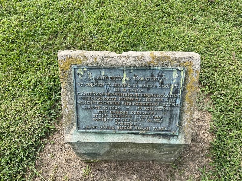
Planted as a tercentenary commemoration to the manorial homes of the men and women who on this site founded Maryland
March 25, 1634 - March 25, 1934. — — Map (db m204925) HM
On Point Breeze Road 0.1 miles east of Colton Point Road, on the left when traveling east.
The Potomac River dory boat was used for the tonging and dredging of oysters in the waters of the Potomac River and its tributaries. Its unique design features a V-bottom planked lengthwise instead of the usual cross-planking. The dory boat . . . — — Map (db m204854) HM
Near Old State House Road at Point Lookout Road (Maryland Route 5).
Mathias de Sousa was the first black Marylander. Of African and Portuguese descent, he was one of nine indentured servants brought to Maryland by Jesuit missionaries and was on The Ark when Lord Baltimore’s expedition arrived in the St. . . . — — Map (db m5626) HM
On Lighthouse Road (Maryland Route 498) south of Hotel Cove Lane, on the left when traveling south.
Most freestanding lighthouses were accompanied by "keeper's quarters," which housed the light keepers and their families. The Piney Point Lighthouse and keeper's quarters were built in 1836 by John Donahoo of Havre de Grace, Maryland. . . . — — Map (db m207240) HM
The Chesapeake Bay and its many tributaries have served as natural highways since the beginning of civilization. With gradual development of villages and settlements along the shorelines, the waterways became the primary means of . . . — — Map (db m192973) HM
On Lighthouse Road (Maryland Route 498) 0.1 miles west of Hotel Cove Lane, on the right when traveling west. Reported permanently removed.
The Potomac River dory boat was built almost exclusively within St. Mary's County, Maryland, and appeared around the 1880s when Maryland was known as the greatest oyster-producing region in the world. Originally designed as a two-masted sailing . . . — — Map (db m203135) HM
On Point Breeze Road west of Dave Bailey Road, on the right when traveling east.
A historical treasure. The Charlotte Hall School is a one-room schoolhouse built in 1820 on land purchased from the Edwards family for $10 per acre. Originally located on Thompson Corner Road in Charlotte Hall, Maryland, the school was . . . — — Map (db m204842) HM
So many new beginnings. A Catholic Mass, the first in English America, was celebrated here on the Island on March 25, 1634. It was a time of beginnings—the first day of the year on the old Julian calendar and the Feast of the Annunciation. . . . — — Map (db m204923) HM
Protecting ships from treacherous waters has been a necessity since ancient times when bonfires and strategically placed cottage lanterns warned seamen of dangers in fog and darkness. Light houses of the Potomac River waterways are variations . . . — — Map (db m192976) HM
On Lighthouse Road (Maryland Route 498) south of Hotel Cove Lane, on the right when traveling south.
Torpedoes arrive at Piney Point. In 1921, the United States Navy sent the first torpedo testing barges from Alexandria, Virginia, to Piney Point. By the onset of World War II, torpedo testing became a regular operation. The Navy purchased . . . — — Map (db m207239) HM
On Lighthouse Road (Maryland Route 498) south of Hotel Cove Lane, on the left when traveling south.
On Christmas Eve 1835, the Federal Government purchased 2.5 acres of land from William and Charlotte Suter for $300. A year later the first lighthouse constructed entirely on the shoreline of the Potomac River went into service at Piney . . . — — Map (db m207241) HM
On Solomons Island Road South (Maryland Route 2) south of Thomas Johnson Road, on the left when traveling south.
This nineteen-foot oystering and crabbing boat was built in 1983 by Francis Goddard of Piney Point, Maryland. Although of relatively recent origin, her design is traditional and she is one of the last of her type to be built in Southern Maryland. . . . — — Map (db m138602) HM
On Lighthouse Road (Route 498) west of Hotel Cove Lane, on the right when traveling west.
Potomac River Dory. The Potomac River dory boat was used for tonging and dredging of oysters in the waters of the Potomac River and its tributaries. Its unique design
features a V-bottom planked lengthwise, instead of the usual . . . — — Map (db m203131) HM
Near Sotterley Lane at Vista Road. Reported permanently removed.
In the 18th century, enslaved African Americans were housed in outlying barns and buildings of the plantation, as well as in the passageways of the manor house. By the 19th century, approximately ten slave cabins were constructed between the . . . — — Map (db m62593) HM
On Point Lookout Road (U.S. 5) at Villa Road, on the right when traveling south on Point Lookout Road.
2000 acres granted Sept. 8th, 1639 to Thomas Cornwaleys who came to Maryland with “The Ark and The Dove.” He and Jerome Hawley were appointed “His Lordship’s Commissioners for the government of said Province” 1633 with . . . — — Map (db m977) HM
On Rennell Avenue West 0.2 miles east of Willows Road, on the left when traveling east.
African Americans continued to migrate to Washington DC, Baltimore, and other urban centers during the worldwide economic depression of the 1930s. However, those who stayed behind working the farms, waterways, and serving as domestics may have . . . — — Map (db m181768) HM
On Point Lookout Road (Maryland Route 5) east of St. Michaels Manor Way, on the right when traveling east.
The U.S. Government, located in Washington D.C., was surrounded by Maryland and Virginia. Since Virginia had already joined the Confederacy, it was critical in the survival of the Union that Maryland not be allowed to secede. The State was . . . — — Map (db m168932) HM
Near Trinity Church Road near Point Lookout Road ( Route 5).
In memory of Thomas Allen Senior, a passenger of the Ark and Dove expedition, member of Assembly of Maryland 1648, Justice of the Peace of Isle of Kent, found shot on the sands of Point Lookout, St. Mary’s County Maryland August 11, 1648. Placed . . . — — Map (db m949) HM
The original Blackistone Lighthouse was built in 1851, ten years before the start of the American Civil War. It was constructed by John Donahoo of Havre De Grace, Maryland, under contract with the U.S. Government. In 1932, it was . . . — — Map (db m204928) HM
Rebuilding for future generations. Josephine Mattingly, granddaughter of Mrs. Josephine Freeman, left a bequest to the St. Clement's Hundred, a non-profit group formed to preserve and enhance St. Clement's Island. Fulfilling this promise, the . . . — — Map (db m204931) HM
Two ships arrive. The 400-ton Ark and the 40-ton Dove landed almost 200 English settlers here in March of 1634. After a stormy passage from England, the 20-year-old Governor Leonard Calvert brother of Lord Baltimore, was looking . . . — — Map (db m204866) HM
This sycamore is the first of 500 new trees to be planted on this "precious spot of land" over the next few years. On October 3, 1993 the Honorable Louis L. Goldstein, Comptroller of the Treasury, State of Maryland, planted this tree on behalf of . . . — — Map (db m204921) HM
Island ties with Bay markets. In 1868, Blackistone's (St. Clement's) Island owner, Dr. Joseph McWilliams, built a steamboat wharf with his sons. The addition opened the island's door to trade with a busy network of Chesapeake Bay ports. Dr. . . . — — Map (db m204926) HM
A rich history. St. Clements Island State Park was the first landfall of settlers to Maryland in 1634. A Potomac River landmark for almost four centuries, it has been a thriving farm, a popular summer resort and a target for large guns. The . . . — — Map (db m204857) HM
On Washington Street just north of Park Avenue, in the median.
The citizens of St. Mary's County dedicate this monument in memory of those who made the supreme sacrifice and those who valiantly served
Korean War
1950 - 1955
• Bennett, Henry A., Pvt USA, Leonardtown, KIA Apr. 11, 1951
• . . . — — Map (db m138982) WM
On Rennell Avenue West just west of South Coral Drive, on the right when traveling west.
The U.S. Navy developed Lexington Park to house white civilian workers who streamed into the area following the establishment of the Patuxent River Naval Air Station. Named for the storied aircraft carrier, USS Lexington, this was the . . . — — Map (db m181773) HM
On Rennell Avenue West just west of South Coral Drive, on the right when traveling west.
In 1942, during the height of World War II, the Department of Defense acquired land in St. Mary's County near the confluence of the Patuxent River Naval Air Station, a facility that would play a crucial role in testing airplanes used on U.S. . . . — — Map (db m181777) HM
The Steuart Petroleum Company, established in 1904, was the Baltimore/Washington D.C. area's largest independent supplier of commercial and residential oil, lubricants and fuel. In 1949, Steuart Petroleum purchased a 320-acre farm bordering . . . — — Map (db m203065) HM
On Lighthouse Road (Maryland Route 498) 0.1 miles west of Hotel Cove Lane, on the right when traveling west. Reported permanently removed.
In 1921, the United States Navy sent the first torpedo testing barge from Alexandria, Virginia to Piney Point where a 33-year testing facility would be established. Later, with the onset of WW II in 1941, the torpedo testing became a 24-hour . . . — — Map (db m138943) HM
On Lighthouse Road (Maryland Route 498) 0.1 miles west of Hotel Cove Lane, on the right when traveling west. Reported permanently removed.
Serving the Washington area since 1904, Steuart Investment Company was a family-owned company headquartered in Chevy Chase, Maryland. Over the years, this company operated many businesses including the Steuart Petroleum Company, also established . . . — — Map (db m138979) HM
African Americans have served in every war since the American Revolution. During the Civil War, more that 180,000 African Americans comprising 170 units served in the Union Army and 29,511 served in the Union Navy. Nearly 700 United States Colored . . . — — Map (db m56476) HM
On Three Notch Road (Maryland Route 5) at Charlotte Hall School Road, on the right when traveling south on Three Notch Road.
St. Mary’s County Welcome Center. Dedicated to all citizens and visitors of St. Mary’s County, Maryland.
In 1634, a group of courageous voyagers left England and all that was familiar and set out for the New World in search of religious . . . — — Map (db m944) HM
The Wharf Connected Leonardtown to the outside world.
Before roads were built, or rails laid for trains, goods and people traveled by ship. In the mid-1600s, ships called directly at the wharves of Maryland plantations to pick up tobacco, . . . — — Map (db m62678) HM
Near Solomons Island Road South (Maryland Route 2) just south of Thomas Johnson Road, on the left when traveling south.
Potomac River dory boats were one of the few V-bottom workboats built on the Chesapeake that were planked fore-and-aft on the bottom, rather than cross-planked. This type was developed on the Potomac River in the later 1800s for oystering under . . . — — Map (db m138581) HM
On Cherryfield Road 0.6 miles north of Boothe Road, on the left when traveling north.
"In later years, I realized how bad it was. At the time, it wasn't no big thing, because you really didn't have nothing else to compare it to. And we did learn how to read and write and add and subtract and so that's better than the . . . — — Map (db m187453) HM
In November 1916, three Catholic priests, Fathers LaFarge, Emerick, and Matthews met with blacks from St. Mary’s county to discuss their plans to have a national industrial school. In May 1917, land was acquired for this school. Archbishop James . . . — — Map (db m128947) HM
On Three Notch Road (Maryland Route 5) at Charlotte Hall School Road, on the right when traveling south on Three Notch Road.
An outgrowth of the “Free Schools” established in Maryland in 1723, founded in 1774 “to provide for the liberal and pious education of the youth of this province, the better to fit them for the discharge of their duties.” . . . — — Map (db m81286) HM
On Rennell Avenue West 0.2 miles east of Willows Road, on the left when traveling east.
In the decade following World War I, citizens of a St. Mary's County still racially and economically divided focused their energies on providing for their families and educating their children toward a promising future.
Economics: . . . — — Map (db m181764) HM
On Point Breeze Road east of Colton Point Road, on the left when traveling east.
The low strip of land across the water in front of you is St. Clement's Island. There, in March of 1634, English settlers first landed on what today is Maryland.
The Catholics among the mostly Protestant settlers were seeking a new life that . . . — — Map (db m204843) HM
On Point Breeze Road 0.1 miles east of Colton Point Road, on the left when traveling east.
A Potomac River landmark, St. Clement's Island has served many functions: a lighthouse site, a summer resort, and farmland. The island became a state park in 1962 and today offers trails, a lighthouse you can explore, wildlife viewing, . . . — — Map (db m204851) HM
On Cherryfield Road 0.5 miles south of Slye Way, on the right when traveling south.
"We had a wood stove. The students had to
bring in the wood. I remember one of the
teachers, she kept a can of water on the
stove, I guess to help the air, and she'd bring a couple of eggs. A certain time of morning, she'd drop . . . — — Map (db m188552) HM
On Cherryfield Road 0.5 miles south of Slye Way, on the right when traveling south.
The Drayden Schoolhouse stands upon its original site on land donated by Mary Ellen and Daniel A. Gross in 1889. The simple one-room design is characteristic of practical Victorian architecture and of other one-room schools in St. Mary's . . . — — Map (db m188554) HM
On Rennell Avenue West 0.2 miles east of Willows Road, on the left when traveling east.
The early 20th c. is commonly referred to as "The Progressive Era." Some of the hallmarks of the era were modernization in communications and transportation and advancements in public health and safety. The expansion of the scope and powers of . . . — — Map (db m181742) HM
In 1774, the Maryland General Assembly passed legislation for the establishment of a school near “Ye Coole Springs” for the education of boys from St. Mary’s, Charles, Calvert, and Prince George’s counties. As a result of the . . . — — Map (db m81186) HM
On Courthouse Drive west of Washington Street ( Route 326), on the right when traveling east.
This cannon was brought to Maryland in 1634 on The Ark. Used in defense of St. Mary’s City and as a St. Inigoes Manor boundary marker. Presented to St. Mary’s County Historical Society by The Society of Jesus.
(original inscription . . . — — Map (db m956) HM
On Maddox Road (Maryland Route 238) at Chaptico Hurry Road, on the left when traveling east on Maddox Road. Reported permanently removed.
Tiny Chaptico was home to many daring men, beginning with John Coode who led Maryland's 1689 Protestant Rebellion. During the Civil War, Chaptico's blockade runners carried medicine and other supplies at night across the Potomac River past Union . . . — — Map (db m282523) HM
On South East Street at Commerce Street, on the right when traveling south on South East Street.
In June 1864, Confederate Gen. Robert E. Lee sent Gen. Jubal A. Early’s corps from Richmond battlefields to the Shenandoah Valley to counter Union Gen. David Hunter’s army. After driving Hunter into West Virginia, Early invaded Maryland to . . . — — Map (db m75747) HM
On Sotterley Lane north of Sotterley Wharf Road, on the right when traveling north.
Sotterley's prime location on the Patuxent River, with access to the Chesapeake Bay, inevitably drew it into conflicts during the Revolutionary War, the War of 1812 and the Civil War.
The Plater families had been prominent in service to . . . — — Map (db m297628) HM
The waterfront was fun and exciting for all ages.
The last quarter of the 19th century has been called Maryland's Golden Age. It was a time of expanding educational and economic opportunities and during those years, the waterfront provided . . . — — Map (db m62711) HM
On Solomons Island Road South south of Alexander Lane, on the right when traveling south.
Named after the first governor of the state of Maryland, the bridge was opened December 17, 1977. It links Calvert County with St. Mary's County. The channel under the center span has a depth of 123'. The fixed bridge has a horizontal . . . — — Map (db m287630) HM
On Washington Street (Business Maryland Route 5) at Leonardtown Road (Business Route 5), in the median on Washington Street.
Named Seymour Town in honor of Governor John Seymour and designated St. Mary’s county seat by the General Assembly in 1708. Name changed to Leonardtown by the General Assembly in 1728 in honor of Leonard Calvert, first colonial governor of . . . — — Map (db m953) HM
On Rennell Avenue West 0.2 miles east of Willows Road, on the left when traveling east.
The Civil War left St. Mary's County with traditional economic and social structures in ruins. For over 150 year Southern Maryland plantation owners had depended on slave labor, and their sympathies were with the Confederacy. Some had crossed . . . — — Map (db m280728) HM
After the battle of Gettysburg, the Union established a prisoner-of-war depot near here. Confederate soldiers and Maryland civilians were imprisoned and guarded by 400 Union troops, with only tents for protection. 3,384 prisoners died. — — Map (db m60283) HM
On West 18th Street at Baynard Boulevard on West 18th Street.
African American Medal of Honor Recipients Memorial
The Medal of Honor takes its place in our country as the highest award for military valor. The honor, awarded by the President in the name of Congress, may only be accorded an . . . — — Map (db m173924) HM WM
On Point Breeze Road 0.2 miles east of Colton Point Road ( Route 242), on the left when traveling east. Reported permanently removed.
The Potomac River dory boat originated around the 1880s and was built almost exclusively within this area of St. Mary's County, Maryland. How the name dory boat came to be is unknown, but its unique design features a V-bottom, planked lengthwise . . . — — Map (db m22148) HM
Near Three Notch Road (Maryland Route 235) east of Laurel Grove Road, on the right when traveling east.
In 2003 the Commissioners of St. Mary's County authorized beginning a rails-to-trails project in St. Mary's County. The Three Notch Trail is a 10' wide multi-use trail constructed on the former railroad right-of-way, which runs south from . . . — — Map (db m135336) HM
Near Lighthouse Road (County Route 498) 1.4 miles east of Piney Point Road (County Route 249), on the left when traveling east.
Here at Piney Point Lighthouse on December 11, 1861, Captain Shore of the steamer Chamberlin disembarked when he saw a distress flag flying. Inside the lighthouse, the wife of Keeper Robert J. Marshall, reported that "five or six loads of . . . — — Map (db m188667) HM
Near Point Lookout Road (Maryland Route 5) 0.2 miles east of Old State House Road, on the right when traveling east.
Most immigrants to early Maryland came as indentured servants. In return for the cost of their voyage, men and women promised to work for four or more years for the person buying their contract or indenture. After completing their promised term, . . . — — Map (db m138692) HM
On Trinity Church Road 0.1 miles west of Point Lookout Road ( Route 5), on the left when traveling west.
In the early 1880s, Marylanders began to commemorate the “lost city” of St. Mary’s as a place of special significance. The 300th anniversary of Maryland’s founding in 1934 brought renewed attention and enthusiasm. The State House replica . . . — — Map (db m959) HM
Near Old State House Road west of Point Lookout Road ( Route 5), on the left when traveling north.
One of the most intriguing residents of Maryland's first capital was Garrett Van Sweringen. Originally a leader of the Dutch colony of New Amstel in Delaware, he lost most of his property when the English captured that settlement in 1664. . . . — — Map (db m138903) HM
Bar Dog got its name from the oyster toadfish, called "bar dogs" by watermen. This is a rare two-log canoe, built in Virginia around 1870. At some point, the canoe was converted from sail to power. It had a Palmer Bros. marine engine when it . . . — — Map (db m138585) HM
Here, where St. Leonard Creek meets the Patuxent River, people lived and events took place that helped shape the region’s — and America’s — history.
Look downriver towards Solomons and see the Governor Thomas Johnson Bridge in the distance. . . . — — Map (db m94695) HM
On Sotterley Lane north of Sotterley Wharf Road, on the right when traveling north.
When the war began in 1861, Sotterley Plantation still relied on slave labor as did other plantations in Southern Maryland. Sotterley's owner, Dr. Walter Hanson Stone Briscoe, served as the surgeon for the Smallwood Vigilantes, a local . . . — — Map (db m297759) HM
On St. Leonard Road (Maryland Route 765) 0.1 miles south of Calvert Beach Road, on the right when traveling south.
The Honorable Thomas Parran (1860-1955)
Thomas Parran, the St. Leonard citizen who played a key role in the construction of the St. Leonard Polling House, was born on February 12, 1860, on the Chestnut Hill Farm (see map) in St. Leonard . . . — — Map (db m181801) HM
Colonial Settlement followed the rivers inland, and harbors with deep water became commercial and social centers. The Maryland colony was founded in 1634, and Chaptico was officially established by 1683. In 1689, Chaptico's John Coode organized a . . . — — Map (db m256081) HM
On Point Lookout Road (Maryland Route 5) east of Old State House Road, on the right when traveling east.
This building before you is one of the oldest standing wooden barns in Maryland. Known today a the Mackall barn, artisans built it in 1785 for John Mackall. After the capital moved to the Annapolis in 1695, John Mackall was the first in a family . . . — — Map (db m138694) HM
On Maddox Road (Maryland Route 238) at Budds Creek Road ( Route 234), on the right when traveling west on Maddox Road.
You are standing at the site of Chaptico's wharf. Despite the Federal forces stationed here, Chaptico's blockade runners carried medicine and other supplies at night down Chaptico Run and across the Potomac River past Union gunships to . . . — — Map (db m282519) HM
On Solomons Island Road South north of Charles Street, on the right when traveling south.
The name "Patuxent" is the diminutive for "Pautuckese," translated means "at the little falls" or "at the falls or rapids." In 1612, Captain John Smith named the river after one of the Werowances villages located along Battle Creek in Calvert . . . — — Map (db m287633) HM
Near Trinity Church Road west of Point Lookout Road ( Route 5).
The National Society, Daughters of Founders and Patriots of America placed this tablet in honor of our National President 1952–1955 Laura Maryland Carpenter Blinn, born in St. Mary’s County and whose ancestors landed here with the Lord . . . — — Map (db m951) HM
Near Balls Bluff Park east of Balls Bluff Road, on the right when traveling west. Reported permanently removed.
Colonel Nathan Evans
A descendant of Welsh nobility, "Shanks" Evans was born in South Carolina in 1824. He was graduated from West Point in 1848 and served with distinction fighting the Plains Indians. In one day in hand-to-hand combat, he . . . — — Map (db m168085) HM
Near Teagues Point Road 0.1 miles south of Fairfax Court.
Discover the War of 1812 on the Star-Spangled Banner National Historic Trail—a path tracing the troop movements through historic places, inspiring landscapes, charming waterfront towns, and waterways of the Chesapeake region.
The trail . . . — — Map (db m128753) HM
Bounded by the Patuxent and the Potomac, St. Mary’s County felt the squeeze as British invaders attacked along both rivers, plundering towns and plantations at will. Officials petitioned for federal help “to rescue and save us.” Little . . . — — Map (db m81180) HM
On Charlotte Hall Road 0.2 miles north of Charlotte Hall School Road, on the left when traveling north.
The Village of Charlotte Hall derived its name from the school located there, authorized by the Maryland General Assembly in 1774. The area was originally known as "Ye Coole Springs" for the purported healing qualities of the drinking water the . . . — — Map (db m135328) HM
During the night of May 19, 1864, Confederate Navy Capt. John Goldsmith and a dozen men slipped past a nearby Union Potomac Flotilla gunboat and disembarked here from the 30-foot sloop Swan. They intended to destroy the Blackistone . . . — — Map (db m204935) HM
Near Reeves Road 0.2 miles south of Old Village Road (Old Route 5), on the right when traveling south.
The federal government purchased the Washington, Brandywine and Point Lookout Railroad, then known as the Farmers' Railroad, in 1942. During WWII, the Navy extended the railroad from Forest Hall to the Patuxent River Naval Air Station to transport . . . — — Map (db m135332) HM
On Court House Drive just east of Washington Street ( Route 326), on the right when traveling east.
Lynching in America. Racial terror lynching claimed the lives of at least 6,500 Black people in the United States between 1865 and 1950. After the Civil War, many white people remained committed to upholding white supremacy. In opposition to . . . — — Map (db m187334) HM
On Rennell Avenue West 0.2 miles east of Willows Road, on the left when traveling east.
Rank and organization: Private, Company C, 38th U.S. Colored Troops. Place and date: At New Market Heights, VA., 29 September 1864. Birth: St. Mary's County, MD. Date of issue: 6 April 1865 . . . — — Map (db m181683) HM WM
On Rennell Avenue West 0.2 miles east of Willows Road, on the left when traveling east.
Rank and organization: Sergeant, Company B, 38th U.S. Colored Troops. Place and date: At New Market Heights, VA., 29 September 1864. Birth: St. Mary's County, MD. Date of issue: 18 February 1874. . . . — — Map (db m181685) HM WM
On Point Lookout Road (Maryland Route 5) at St. Michaels Manor Way, on the right when traveling east on Point Lookout Road.
To the memory of
→•←
seventeen
— unknown —
Confederate dead,
who fell in front of
Washington, D.C.
July 12, 1864.
— by their —
comrades. — — Map (db m76032) WM
Near Wilmott Drive, on the left when traveling south. Reported missing.
Nearby stood Camp Stanton, a Civil War-era recruiting and training post for African American Union soldiers. Named for Secretary of War Edwin Stanton, the camp was established in August 1863. Although black soldiers had served in the nation’s armed . . . — — Map (db m195735) HM
Near Charlotte Hall Road south of Oaks Road, on the right when traveling south.
William F. Chesley began his railroad career as a telegraph operator for the Kansas City Southern Railroad in 1906. He worked every position on the line from track worker to manager.
Mr. Chesley returned home to St. Mary's County and in 1924 . . . — — Map (db m135327) HM
On Court House Drive east of Washington Street ( Route 326), on the right when traveling east.
In 1860, male voters gathered here at the courthouse to cast their ballots. Before the mid-nineteenth century, voice voting was common, with each voter announcing his choices in front of one and all. Then came paper tickets or ballots colorfully . . . — — Map (db m187359) HM
On Rennell Avenue, W west of S. Coral Place, on the right when traveling west.
The U.S. Navy developed Lexington Park to house the civilian workers who streamed into the area following the establishment of the Patuxent River Naval Air Station. Named for the storied carrier Lexington, it was the first planned community . . . — — Map (db m56719) HM
On Three Notch Road (Maryland Route 235) 0.1 miles north of Buse Road, on the left when traveling south.
During the Civil War, more than 700 African American men from St. Mary's County served as soldiers and sailors in the U.S. Army and Navy. Some enlisted to obtain their freedom; some were already free and joined from a sense of duty. Black men . . . — — Map (db m181789) HM
Near Lighthouse Road (County Route 498) 1.4 miles east of Piney Point Road (County Route 249), on the left when traveling east. Reported permanently removed.
In 1861, the U.S. created the Potomac Flotilla (gunboats and other armed vessels) to patrol the river and intercept Confederate blockade runners. Nevertheless, St. Mary's County residents frequently ferried supplies and men across to Virginia. A . . . — — Map (db m188560) HM
Near Point Lookout Trail west of Point Lookout Road ( Route 5), on the right when traveling south.
This site, where the Chesapeake Bay and Potomac River merge, was an observation post for Americans during the War of 1812. It was also staging area for local militia in early summer of 1813.
Two- to Three-thousand British troops occupied the . . . — — Map (db m62446) HM
The Price of Prosperity
By the latter part of the 17th century, the development of the plantation economy of Maryland was well established. The shift of political power from English nobles to wealthy planters and fewer indentured servants . . . — — Map (db m146563) HM
Leonardtown's Early Years
Carved from a large land grant named New Towne Hundred by an act of Maryland's Early Colonial government to advance commerce, this area had been known by several other names --Sheppard's Old Fields, Seymour Towne, . . . — — Map (db m81523) HM
An elderly, single, migrant to St. Mary's County, Moll Dyer lived alone in a small cabin just south of Leonardtown. Known to practice strange customs, concoct herbal medicines, and suspected of casting spells, Dyer was viewed with suspicion and . . . — — Map (db m187333) HM
On Rennell Avenue, W. west of S. Coral Drive, on the right when traveling west.
In 1942, the Department of Defense acquired land in St. Mary’s County and began construction of the Patuxent River Naval Air Station, a facility that would play a crucial role in testing airplanes used on World War II aircraft carriers. The . . . — — Map (db m56863) HM
On Washington Street (Maryland Route 326) just south of Nuthall Lane, on the right when traveling south.
The Breton Bay area has a rich and significant human history, beginning as early as 13,000 years ago. Cooler temperatures and lower sea levels at the time meant that the shoreline extended much further than it does today.
The abundant wild . . . — — Map (db m187448) HM
On Tulagi Place at Three Notch Road on Tulagi Place.
The Monument, a project of Unified Committee for Afro-American Contributions of St. Mary's County, was dedicated On July 29, 2000, Its purpose is to serve as an external reminder of the contributions of African Americans to the growth and . . . — — Map (db m128945) HM
On Church Street, on the right when traveling north.
First Baptist Church
Founded in 1823 as Edgefield Baptist Church, with Basil Manly, Sr., Pastor, Matthew Mims, Clerk, and Arthur Simkins, Moderator, this church led in the establishment here in 1826 of Furman Academy and Theological . . . — — Map (db m12671) HM
Thin black lines indicate changes in relevance. Between each pair of lines entries are ordered geographically but all have the same relevance.
* Inflectional forms of words are their plurals, singulars, and possessives as well as gramatical tenses and similar variations.