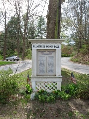
On Plumtrees Road at Taylor Road, on the right when traveling north on Plumtrees Road.
Plumtrees Honor Roll
Parmly Brown • John E. Nelson • Leland Grumman Jr.
Warren Abrams • Arthur Appell • George S Bates • Thomas Bergstrom • Arthur C. Brown • Raymond Capellaro • George Cher • Michael Cher • Stephen Cher • Richard Collier • William . . . — — Map (db m55005) HM
On Plumtrees Road at Taylor Road, on the right when traveling north on Plumtrees Road.
Plumtrees School
The Plumtrees School was built in 1867 as a one room school house for the Plumtrees District of Bethel. The school served the community from 1867 through 1970. At its closing it was the last operating one room school house in . . . — — Map (db m55006) HM
On Main Street at Chestnut Street, on the left when traveling east on Main Street.
Bethel
When this area was settled, soon after 1685, it was part of its present neighbor, Danbury. As population grew, residents petitioned the General Assembly of the Colony for parish status and a church closer than the center of Danbury. In 1759 . . . — — Map (db m114646) HM
On Depot Place at South Street, on the right when traveling south on Depot Place.
The above photo depicts Bethel’s second train station that was completed in 1899 and provided passenger service until 1996 when a new station was constructed further north along the line. Bethel’s original train station occupied this same spot from . . . — — Map (db m48431) HM
Near South Street, 0.1 miles Rector Street, on the left when traveling west.
[ north face ]
In Memory
Of The
Soldiers & Sailors
Of Bethel
Who Gave Their Lives
In Defense Of The Union
1861 1865
[ south face ]
Albert Woodruff 2nd Conn. Art.
Adam Grimm 7th Conn.
James Smith . . . — — Map (db m26819) HM
On School Street at Library Place, on the left when traveling west on School Street.
This monument is dedicated to the brave men and women of the town of Bethel who, in times of war and peace, have faithfully served their country. We honor and express gratitude for their courage and the sacrifices they made to keep America a free . . . — — Map (db m21234) HM
On Greenwood Avenue (Connecticut Route 302) at Library Place, on the right when traveling west on Greenwood Avenue.
“I was born and reared in an atmosphere of merriment my natural bias was developed and strengthened by the associations of my youth; and I feel myself entitled to record the sayings and doings of the wags and eccentricities of Bethel because . . . — — Map (db m69926) HM
Near Noble Avenue north of Crown Street, on the left when traveling north.
Status: Threatened
Formerly an endangered species due to poaching, their population has increased thanks to environmental awareness programs at zoos like Connecticut's Beardsley Zoo.
Near Noble Avenue north of Crown Street, on the left when traveling north.
Size: up to 12.5 feet in length[;] up to 6.5 feet at the shoulders
Weight: up to 2,500 lbs[;] males larger than females
Lifespan: 15-20 years in the wild[;] up to 40 years in captivity
Habitat: grasslands . . . — — Map (db m230894) HM
Near Noble Avenue north of Crown Street, on the left when traveling north.
Size: 18 - 30 inches at the shoulder
Weight: males weigh between 80-200 pounds, females weigh between 62-132 pounds
Lifespan: 10 - 15 years average, up to 20 years
Habitat: temperate forest, with a wide range of . . . — — Map (db m230906) HM
Near Noble Avenue north of Crown Street, on the left when traveling north.
It is estimated that between 1970 - 1983, the Amur leopard lost 80% of its former territory. Indiscriminate logging, forest fires and land conversion for farming are the main causes. There is still hope. Large tracts of forest, which are ideal . . . — — Map (db m230916) HM
Near Noble Avenue north of Crown Street, on the left when traveling north.
AZA Tiger Conservation Campaign
Connecticut's Beardsley Zoo supports the Amur Tiger Conservation projects sponsored by the AZA Tiger Species Survival Plan. The first survey of Amur tigers in the 1930's estimated that only 20 - 30 remained . . . — — Map (db m230926) HM
Near Noble Avenue north of Crown Street, on the left when traveling north.
Height: 4 feet
Weight: up to 33 lbs
Wingspan: 10 to 12 feet
Males: brown eyes,
Females: red eyes and lack the head crest Or carbuncle.
Lifespan: 50 years in the wild. Over 75 years in human . . . — — Map (db m230842) HM
Near Noble Avenue north of Crown Street, on the left when traveling north.
The eagle's drastic decline in the mid-20th century has been attributed to the widespread use of the pesticide DDT. In a process called biological magnification (brought brought forth to the general public by Rachel Carson in her book Silent . . . — — Map (db m230922) HM
Near Noble Avenue north of Crown Street, on the left when traveling north.
Size: 34-43 inches in length
Weight: males 8-9 lbs, females 10-14 lbs
Wingspan: 6-7.5 feet
Lifespan: 25 to 30 in the wild[;] up to 60 years in captivity
Habitat: lakes, rivers and seacoasts
Diet: fish, . . . — — Map (db m230923) HM
Near Noble Avenue north of Crown Street, on the left when traveling north.
Size: 17-20 inches[;] wingspan of 39-43 inches
Weight: 2.5 lbs
Lifespan: 18 years in the wild[;] over 20 years in captivity
Habitat: coniferous forests, swamp and riparian forests
Diet: small mammals, birds, . . . — — Map (db m230893) HM
Near Noble Avenue north of Crown Street, on the left when traveling north.
Size: 19-20 inches
Wingspan: 38-42 inches
Weight: 1.6 pounds
Females are larger than males
Lifespan: 23 years in human care and 10 years or more in the wild
Habitat: Mature forests are their preferred . . . — — Map (db m230934) HM
Near Noble Avenue near Crown Street, on the left when traveling north.
Bears have fascinated and inspired humans since our ancient ancestors first explored the wild world around them and gazed at the skies above.
They connect us deeply with the natural world around us.
Inspired by the rising sun, Sun bears . . . — — Map (db m230880) HM
On Noble Avenue north of Crown Street, on the left when traveling north.
For thousands of years, tribal people around the world have relied on certain animals to provide them with meat, milk, shelter, tools and transportation. Middle-Eastern tribes have relied on Dromedary camels, northern Eurasian tribes have relied . . . — — Map (db m230898) HM
Near Noble Avenue north of Crown Street, on the left when traveling north.
Size: up to 16 inches
Weight: up to 3.5 lbs
Lifespan: 5-8 years in the wild[;] 8-12 years in captivity
Habitat: open, level, arid, short and medium-grass plains
Diet: grasses, weeds, forbs, roots, a small . . . — — Map (db m230882) HM
Near Noble Avenue north of Crown Street, on the left when traveling north.
Size: 1.5-2.5 feet at shoulder
Weight: 66-88 pounds
Lifespan: Up to 9 years
Habitat: Dry thorn forests, plains and marshes of South America
Diet: Cacti, tubers, fruits, flowers
Near Noble Avenue north of Crown Street, on the left when traveling north.
Our Big Cow was originally displayed at the Danbury Fair, one of the largest agriculture fairs in the country for many years.
Thank you to our Big Cow sponsor, Wade's Dairy.
The Big Cow has also become a Time Capsule to be opened in . . . — — Map (db m230931) HM
Near Noble Avenue north of Crown Street, on the left when traveling north.
Wild cattle originated in North Africa, Europe and Southern Asia. Domestic cattle are found worldwide.
Cattle are large, hoofed mammals. They graze on rangelands throughout the world.
Cattle breeds vary in color, shape and size. The . . . — — Map (db m230940) HM
Near Noble Avenue north of Crown Street, on the left when traveling north.
People have kept goat herds for more than 10,000 years.
They originated in Central Asia and are now found worldwide.
The many breeds of domestic goats vary in color, shape and size. The largest breeds can weigh up to 250 pounds, while . . . — — Map (db m230937) HM
On East Main Street (Connecticut Route 127) at Beverly Place, on the right when traveling south on East Main Street.
Frederick Law Olmsted
Beardsley Park was originally designed by Frederick Law Olmsted during the 1880's, and the design completed by his sons in the early 20th century. Known as the father of American landscape architecture, Olmsted . . . — — Map (db m230835) HM
Near Noble Avenue north of Crown Street, on the left when traveling north.
Height at shoulder: 21 - 24 inches
Weight: 150 to 300 lbs
Habitat: Farms across Europe, Africa and the United States
Diet: Shrubs, weeds, bird eggs, mice grasshoppers, roots, tubers, even manure
Status: This . . . — — Map (db m230939) HM
Near Noble Avenue north of Crown Street, on the left when traveling north.
One of the two Amur leopards at Connecticut's Beardsley Zoo is melanistic, causing her to appear all black, while the male has the usual coat pattern. At first, a melanistic cat might look solid black, but even melanistic leopards are spotted. If . . . — — Map (db m230917) HM
Near Noble Avenue north of Crown Street, on the left when traveling north.
Size: 18-30 inches at the shoulder
Weight: 70 to 90 lbs
Lifespan: up to 15 years
Habitat: mountain forests, grasslands and shrublands
Diet: elk, white-tailed deer, mule deer, also known to eat smaller . . . — — Map (db m230875) HM
Near Noble Avenue north of Crown Street, on the left when traveling north.
Size: no taller than 34 inches, measured at the top of the shoulders
Weight: between 150 and 350 pounds
Lifespan: from 25 to 35 years
Found in many nations, particularly in Europe and the Americas
Near Noble Avenue north of Crown Street, on the left when traveling north.
Our myths and legends about wolves vary from reverence to fear.
753 B.C.
Mother to mythic heroes
According to Roman mythology. Romulus and Remus were nurtured as infants by a "she-wolf." Romulus founded the city of Rome on the Tiber . . . — — Map (db m230843) HM
Near Noble Avenue north of Crown Street, on the left when traveling north.
Named for Narragansett Bay in Rhode Island, this is the oldest turkey variety developed in the United States. They originate from the breeding of native wild turkeys in New England to domesticated species brought here by European settlers. . . . — — Map (db m230944) HM
Near Noble Avenue north of Crown Street, on the left when traveling north.
Beardsley Park Zoo was founded as a menagerie featuring animals donated by the P.T. Barnum Circus and area residents. With the historic Greenhouse as a central feature of the park, the Zoo became a beautiful recreation site where visitors could . . . — — Map (db m230840) HM
Near Noble Avenue north of Crown Street, on the left when traveling north.
Wolves have been brought to near extinction, mainly due to conflicts with humans.
1630 - Present
Bounty Hunting for Wolves
In 1630, Massachusetts colonists passed the first wolf bounty law in America. They sought to eliminate wolves . . . — — Map (db m230845) HM
Near Noble Avenue north of Crown Street, on the left when traveling north.
Bearly Recognizable:
While bears come in a wide variety of sizes and colors, all bears have some things in common. Large, powerful, well-furred bodies, long snouts with super-sensitive noses, broad paws with sharp claws and tiny tails are . . . — — Map (db m230878) HM
Near Noble Avenue near Crown Street when traveling north.
Description: Short reddish brown to tawny gray fur, long legs and large ears.
Size: 18"-26" at the shoulder
Weight: 40-90 lbs
Lifespan: 6-7 years in the wild, up to 15 years in captivity
Near Noble Avenue north of Crown Street, on the left when traveling north.
Peafowl are native to India. The males, known as peacocks, are brightly-colored to attract females (peahens).
Guineafowl are native to Africa. Their keen eyesight enables them to prey on invertebrates.
Wild Turkeys are true "American . . . — — Map (db m230945) HM
Near Noble Avenue north of Crown Street, on the left when traveling north.
Size: about 3' tall at the shoulder, length of 6'-7'
Weight: 90 - 130 lbs for females, 130 - 220 lbs for males
Lifespan: up to 10 years in the wild, and up to 20 years in captivity
Diet: a wide variety of . . . — — Map (db m230895) HM
Near Noble Avenue north of Crown Street, on the left when traveling north.
White tigers are not a separate species. All white tigers in North America are the descendants of a single tiger captured in 1951. Generations of inbreeding have increased the frequency of the white coat. Because of this inbreeding and the . . . — — Map (db m230928) HM
On State Street at Markle Court, on the left when traveling east on State Street.
Abraham Lincoln visited this city Saturday evening March 10, 1860, and delivered a political address before a large audience of citizens in Washington Hall, which was then a portion of this building. — — Map (db m170212) HM
On Broad Street at State Street, on the right when traveling south on Broad Street.
Bridgeport
"The Park City"
The area that is now Bridgeport was settled in the mid-17th century by farmers from the older towns of Stratford and Fairfield. Centers of settlement were Stratfield, present North Avenue; Pembroke, now Old Mill Green; . . . — — Map (db m91834) HM
On Broad Street at State Street, on the right when traveling north on Broad Street.
Korea Memorial
Freedom is not free
I will never leave you or forsake you
Hebrews 13 5
In my generation this was not the first occasion
when the strong attacked the
weak. Communism was acting in Korea just as
Hitler, Mussolini and . . . — — Map (db m170213) WM
On Broad Street at State Street, on the right when traveling north on Broad Street.
This Tablet Is Dedicated To Bridgeports Sons And Daughters Who Gave Up Their Lives That The World Might Re A Better Place In Which To Live
Agnew, James • Altman, Walter G. • Anderson, Martin A. • Armstrong, Thomas • Baltonsaita, Ignatz • Banks, . . . — — Map (db m91929) WM
On Broad Street at State Street, on the right when traveling north on Broad Street.
Vietnam
This Memorial Is Dedicated To
Those Who Have Given The Supreme
Sacrifice To Their Country
“If Ye Break Faith
We Shall Have Died In Vain”
Donated By Concerned Citizens
Dedicated - May 29, 1983
( left panel . . . — — Map (db m91928) WM
On Broad Street at State Street, on the right when traveling north on Broad Street.
World War II Memorial
To those who made the ultimate sacrifice so that others would live
Aaron, William • Adams, Thomas • Adelman, Harold • Aitkin, Richard W. • Akalis, Anthony J. • Alderucci, Salvatore • Aleksiewicz, Stephen N. • Anagnos, . . . — — Map (db m91973) WM
On Broad Street at State Street, on the right when traveling north on Broad Street.
In Recognition
Of The Patriotism Of Our Employees
Who Entered The Service Of Our Country
During The Great War
1914 – 1918
The Bryant Electric Company — — Map (db m91931) WM
On Broad Street at State Street, on the right when traveling north on Broad Street.
In Commemoration
Of Those Employees Who Served
In the Armed Forces of the United States
During World War II
1941 – 1945
The Bryant Electric Company — — Map (db m91927) WM
On Lyon Terrace at Golden Hill Street, on the right when traveling south on Lyon Terrace.
This Marker Commemorates The
150th Anniversary
Of The City Of Bridgeport
During This 150th Year
The People Of Bridgeport Reflected On Their Past
Celebrated Their Present Life Together,
And Planned For A Future Full Of Hope And . . . — — Map (db m91975) HM
On Broad Street at South Frontage Road, on the right when traveling north on Broad Street.
James Henry O'Rourke
September 1, 1850 - January 8, 1919
‘Orator Jim' O'Rourke, son of Irish immigrants, was a professional baseball player, scholar, and civil rights activist. The Bridgeport native had the first base hit in National League . . . — — Map (db m91832) HM
On Golden Hill Street at Lafayette Square, on the right when traveling south on Golden Hill Street.
In memory of the construction workers who died at L'Ambiance Plaza April 23, 1987
Michael Addona • Augustus Allman • Glenn Canning • Mario Colello • Francesco D’Adonna • William Daddona • Donald Emanuel • Vincent Figliomeni • Herbert Goeldner, . . . — — Map (db m91977) HM
On Broad Street at State Street, on the right when traveling south on Broad Street.
Lewis Howard Latimer
September 4, 1848 – December 11, 1928
Considered one of the 10 most important black inventors in US history. Lewis Latimer was renowned for his work with the Edison Pioneers. Of his many inventions and patents, his most . . . — — Map (db m91836) HM
On East Washington Avenue at Noble Avenue on East Washington Avenue.
In 1851, P.T. Barnum and William Noble took the land that we now stand on and developed it. Lots were planned and streets were named after their own family members such as Caroline, Hallet, and of course Barnum. A firm was hired to design an English . . . — — Map (db m227305) HM
On Barnum Avenue at Kossuth Street, on the left when traveling west on Barnum Avenue.
In 1851, P.T. Barnum and William Noble took the land that we now stand on and developed it. Lots were planned and streets were named after their own family members such as Caroline, Hallet, and of course Barnum. A firm was hired to design an English . . . — — Map (db m227306) HM
On Noble Avenue north of Crown Street, on the left when traveling north.
Dexter cattle are the smallest North American breed of cattle. Dexter cattle were originally brought to the U.S. in 1912 from Ireland and quickly became popular due to their ideal size for the small family farms of the time. . . . — — Map (db m230943) HM
Near Waldemere Avenue near Park Avenue, on the left when traveling west.
[ south plaque ] Dedicated To The Memory Of The Heroic Men Of Bridgeport, Who Fell In The Late War For The Preservation Of The Union. July, 1876 "It is for us the living to be here dedicated to the great task remaining before us, that from . . . — — Map (db m27137) HM
On Waldemere Avenue at Park Avenue, on the left when traveling west on Waldemere Avenue.
[Inscription on the street (east) side]
This Memorial Arch was erected
AD MCMXVIII to the memory of
William Hunt Perry
of Bridgeport Conn by his wife
Harriet Adelaide Perry
[Inscription on the park side]
This Memorial . . . — — Map (db m27166) HM
Near Waldemere Avenue west of Iranistan Avenue, on the left when traveling west.
The test of mankind's progress is not whether we add more to the abundance of those who have much; it is whether we provide enough for those who have too little. — — Map (db m170069) HM
On Soundview Drive at Monument Drive, on the left when traveling west on Soundview Drive.
In Memoriam
U.S.S. Maine
Destroyed in Havana Harbor
February 15th 1898
This tablet is cast from metal recovered from the U.S.S. Maine — — Map (db m27128) HM
Near Dewey Street near Maplewood Avenue, on the left when traveling north.
[ battle names on the banner at the top ]
Fort Sumter • Vicksburg • Mobile Bay • Antietam • Gettysburg • Appomattox
First Conn Cavalry
Richard R Crawford Lt D d Oct 30 1863 In Hospital Va
Eugene W Starkweather Corp L d . . . — — Map (db m27213) HM
Near Dewey Street at Maplewood Avenue, on the left when traveling north.
This monument is a memorial to Charles S. Stratton, a native of Bridgeport, who gained worldwide fame as Tom Thumb in the exhibitions of P.T. Barnum. The lifesize statue was erected before Tom Thumb's death on July 15, 1883. In 1959 vandals smashed . . . — — Map (db m27168) HM
On Whisconier Road (Connecticut Route 25) at Obtuse Hill Road (Connecticut Route 133), on the right when traveling north on Whisconier Road.
Brookfield
Parish of Newbury
The land which comprises the geographical area of Brookfield belonged to the towns of Danbury, Newtown, and New Milford. In 1754 the Parish of Newbury was incorporated by decree of the General Assembly with boundaries . . . — — Map (db m35170) HM
On Deer Hill Avenue at West Street, on the right on Deer Hill Avenue.
The potato famine of 1846-1851 brought large numbers of Irish immigrants to town. Many purchased homes in the Town Hill neighborhood and St. Peter Church became a focal point for the community.
Germans immigrants were the first major group . . . — — Map (db m71353) HM
On Main Street at Library Place, on the right when traveling south on Main Street.
This handsome Victorian Romanesque building was built as the new headquarters for the Danbury National Bank in 1887.
The architect, Warren Biggs of Bridgeport, used stone from Massachusetts. The building is constructed of Longmeadow . . . — — Map (db m72859) HM
On Memorial Drive, on the left when traveling south.
Afghanistan Iraq ( Iraq War Veterans )
Corporal Kemephoom A. Chanawongse U.S. Marine Corps · Gunnery Sergeant Phillip A. Jordan U.S. Marine Corps · Specialist Wilfredo Perez, Jr. U.S. Army · Staff Sergeant Richard S. Eaton, Jr. U.S. Army . . . — — Map (db m247878) HM
On Ellsworth Avenue, 0.1 miles west of Summit Street when traveling north.
Dedicated to the Memory Of the Black Soldiers of Greater Danbury who Served in the 29th and 30th Regiments, Conn. Volunteer Infantry During the Civil War 1861 – 1865
[ Names inscribed on the back ]
29th Conn . . . — — Map (db m23052) HM
Near White Street at Balmforth Avenue, on the right when traveling east.
Boston & Maine ALCO 2-6-0 Mogul 1455
This steam locomotive was built by the American Locomotive Company in 1907 for the Boston and Maine Railroad, eventually ending up on the Cape Cod Railroad. It was still pulling commuter trains from Boston’s . . . — — Map (db m89544) HM
On Main Street at Library Place, on the right when traveling south on Main Street.
Charles Edward Ives, the ‘Father of Modern Music,’ was born in Danbury on October 20, 1874 to a prominent New England family who were leading citizens of he community. His grandfather, George White Ives, founder of The Savings Bank of Danbury, . . . — — Map (db m71183) HM
On Wooster Street at Deer Hill Avenue, on the right when traveling east on Wooster Street.
Many Danbury land records were destroyed during the British raid of 1777. Historic newspapers, old deeds and early maps help us piece together some of the earliest place names of our city.
Parts of Danbury were lost to Bethel when it broke . . . — — Map (db m71348) HM
Near White Street at Balmforth Avenue, on the right when traveling east.
CV Flatcar
Built in 1923 this flatcar ran on the Central Vermont Railway. It was used at the Bullard Steel Mill in Bridgeport, CT. during the end of its active railroad life. The museum restored this car after purchasing it in 1997. Please note the . . . — — Map (db m89541) HM
On Main Street at Wooster Street, on the left when traveling north on Main Street.
Eight families came from Norwalk in 1685 to settle this area which the Indians called Pahquioque. They built their first homes a half mile south of here and made this green their common. The General Court in October 1687 decreed the . . . — — Map (db m22836) HM
On Main Street at West Street, on the right when traveling north on Main Street.
Although local folklore credits a man by the name of Zadoc Benedict with the start of hatting in Danbury after the Revolutionary War, hatters are thought to have been at work in the Danbury community before that time.
After the . . . — — Map (db m71237) HM
On Main Street at Wooster Street, on the left when traveling south on Main Street.
Dedicated in loving memory to Connecticut victims of the terrorist attack on the United States September 11, 2001
Mayor Mark D. Boughton Danbury 9-11 Memorial Committee September 11, 2004 — — Map (db m22833) HM
On Memorial Drive at South Street (Connecticut Route 53), on the left when traveling south on Memorial Drive.
Korean War
1950 – 1953
to those who died
Honor and Eternal Rest
to those still missing
Rememberance and Hope
to those who returned
Gratitude and Peace
[Inscribed on the left panel]
Danbury . . . — — Map (db m23404) WM
On South Street (Connecticut Route 53) at Memorial Drive, on the right when traveling east on South Street.
1964 Vietnam War 1975
Dedicated this 29th day of May 1988 by the people of the greated Danbury area to those men and women who served their country during the Vietnam War.
This memorial symbolizes the courage and sacrifices made by . . . — — Map (db m43312) HM
On South Street (Connecticut Route 53) at Memorial Drive, on the right when traveling east on South Street.
Dedicated to the Memory
of the Black Soldiers of the
Greater Danbury who served in
the 29th and 30th Regiments Conn.
Volunteer Infantry during the Civil War
1861 — 1865 — — Map (db m248825) WM
On Main Street at West Street, on the right when traveling south on Main Street.
Between 1886 and 1970 the Danbury City Hall was situated in the site of the present library courtyard. This wall, part of the original structure, stands as an enduring symbol preserving our City’s historic heritage. — — Map (db m22790) HM
On Crosby Street near Main Street, on the left when traveling west.
When the Kohanza Reservoir Dam gave way on the night of February 20, 1869, sixty acres of water, ice, lumber and debris roared down north Main Street. It took shops, homes, bridges and factories with it and several lives were lost. A combination . . . — — Map (db m72857) HM
On Main Street, 0.1 miles north of South Street, on the right when traveling north.
On April 26, 1777, 2,000 British soldiers, under the command of General Tryon, marched into Danbury. The town was a supply depot for military stores.
A Corps of Artificers; skilled craftsmen, such as blacksmiths, were formed into special . . . — — Map (db m72558) HM
On Main Street (Connecticut Route 53) just south of West Street, on the right when traveling north.
Entertainment in Danbury has taken many forms. Buffalo Bill's Wild West Show and traveling circuses that passed through town competed with church-related activities and civic events.
The Taylor Opera House, built in 1870 provided first . . . — — Map (db m230137) HM
On Main Street at Library Place, on the right when traveling north on Main Street.
The origins of the Danbury Fair began in 1821 when the Fairfield Agricultural Society held gatherings in Elmwood Park on Main Street. The event gave farmers an opportunity to discuss farming methods and showcase the fruits of their labor. . . . — — Map (db m71186) HM
On West Street at Foster Street, on the right when traveling west on West Street.
• First recorded census taken in 1756, Danbury’s population: 1,527.
• Danbury’s first mayor, elected in 1888, was Lewis LeGrand Hopkins.
• The first train arrived on the tracks of the Danbury & Norwalk Railroad on March 1, 1851.
• . . . — — Map (db m152995) HM
On Memorial Drive at South Street, on the left when traveling south on Memorial Drive.
Center Marker:In Honor of
The Men and Women
of Danbury
who served in the World War
1917 – 1919
In Memory of these men who
made the supreme sacrifice
for liberty
Toby Asmar Co. M. 325th Infantry Killed In Action . . . — — Map (db m23084) WM
On West Street at Foster Street, on the right when traveling west on West Street.
Throughout its history, countless women have contributed to Danbury and the lives of its citizens. Here are just a few that have left their mark on our community.
Mary Bull (1812-1882) dedicated her life to attending the poor and needy of . . . — — Map (db m71247) HM
On Memorial Drive, 0.1 miles south of Lions Way, on the right when traveling south.
In Memory of All Danbury
World War II Veterans
This memorial is in honor of all of World War II Veterans who were involved in the fight for the freedom of America and the free world.
Whether they fought in the Pacific or European . . . — — Map (db m23398) HM
Near White Street at Balmforth Avenue, on the right when traveling east.
Located opposite from where you’re standing stood the roundhouse and adjoining machine shop facility for the Danbury Yard. Built in circa 1914 the structure had 9 stalls for storage, servicing and performing light repairs to the many locomotives . . . — — Map (db m89546) HM
On Ellsworth Avenue, 0.1 miles west of Summit Street, on the left when traveling north.
[ North face ]
David Wooster First Maj. Gen. of the Conn. Troops in the Army of the Revolution. Brig. Gen. of the United Colonies. Born at Stratford, Mar. 2, 1710-11. Wounded at Ridgefield, April 27, 1777, while defending . . . — — Map (db m23074) HM
On Deer Hill Avenue at West Street, on the right when traveling north on Deer Hill Avenue.
The start of the 20th century saw a continual influx of newcomers to Danbury. A religious census taken in 1916 showed that 27 nationalities and 20 creeds were represented among the 22,533 residents of the town.
The 1910 census shows that a . . . — — Map (db m71473) HM
On Deer Hill Avenue at West Street, on the right when traveling north on Deer Hill Avenue.
The first eight families arrived here in 1685; full of hope as they embarked on a new life filled with opportunity. Others soon joined them in this flourishing settlement in a newly born colony.
Most of Danbury’s inhabitants, prior to the . . . — — Map (db m71352) HM
On Main Street at Boughton Street, on the left when traveling south on Main Street.
In 1801, Mr. Major Starr donated the land necessary to take a large curve out of Main Street on condition that it serve as a permanent common. To this end, residents from the southern end of the street raised their own funds and created Elmwood . . . — — Map (db m71476) HM
On Deer Hill Avenue at George Street, on the right when traveling north on Deer Hill Avenue.
During the colonial period, agriculture was the principal occupation in Danbury. The daily tasks of our early settlers included clearing land, raising cattle, growing wheat, rye, corn, beans and squash.
Broad flat tracts of fertile ground . . . — — Map (db m71351) HM
On White Street at Main Street, on the right when traveling west on White Street.
Continuing educational opportunities have long been available in Danbury. In the late 1800s, the Stillman’s Business College, at the corner on Main and White Streets, offered classes in penmanship, commercial law and bookkeeping.
The . . . — — Map (db m71136) HM
On South Street at Main Street, on the left when traveling east on South Street.
Historic Site
Danbury’s First Episcopal Church occupied this site from 1763 until 1884. In 1777, British troops, led by General Tryon, took military stores from the church and burned them in the nearby street, but spared the edifice.
Three . . . — — Map (db m72562) HM
Near White Street east of Patriot Drive, on the right when traveling east.
Alfred Hitchcock filmed portions of his 1951 film Strangers on a Train on this very platform. In the movie, Danbury Union Station played the part of the fictional 'Metcalf Station.' — — Map (db m230162) HM
Near White Street east of Patriot Drive, on the right when traveling east.
Alfred Hitchcock filmed portions of his 1951 film Strangers on a Train on this very platform. In the movie, Danbury Union Station played the part of the fictional 'Metcalf Station.' — — Map (db m230164) HM
2459 entries matched your criteria. The first 100 are listed above. Next 100 ⊳