On Baltimore Street at Canal Street, on the right when traveling east on Baltimore Street.
Through the joint effort of
Operation Gateway
Allegany County Bicentennial Committee
Cumberland Urban Renewal Agency
and the Citizens of Cumberland
In Celebration of
The American Revolution Bicentennial — — Map (db m204085) WM
On Washington Street just east of Prospect Square, on the right when traveling east.
Indians served on both sides during the French and Indian War. Some tribes seemed to switch loyalties during the war, when it better suited their purposes. Indians camped near here to consult with General Braddock just before his fateful . . . — — Map (db m139102) HM
This monument was erected in memory of the Irish laborers who died building the Chesapeake and Ohio Canal and the Baltimore and Ohio Railroad
1828 – 1850 — — Map (db m140190) HM
On Evitts Creek Drive Southeast south of East Industrial Highway (Maryland Route 51), on the right when traveling south.
Jane Frazier
wife of
Lieut. John Frazier
was captured by Indians near this spot in October 1755 and taken to the Miami River. She escaped after eighteen months and made her way back to her home. — — Map (db m402) HM
On W. Harrison Street, on the right when traveling south.
The Chesapeake and Ohio Canal ran from Georgetown in Washington, D.C. (Mile 0) to Cumberland, MD (Mile 184.5), paralleling the Potomac River. Most of the heavy shipping originated from the western terminus at Cumberland. Boatmen carrying coal, . . . — — Map (db m67482) HM
On Greene Street at Canal Street, on the right when traveling east on Greene Street. Reported unreadable.
The Light the Steeples Committee of the Allegany
County Chamber of Commerce extends gratefully
to the Cumberland community and local schools
for participating in lighting the steepled sky in
Cumberland, Maryland
November 10, 1995 — — Map (db m204087) HM
On Prospect Square just south of Washington Street, on the left when traveling south.
Lynching in America
Racial terror lynching between 1865 and 1950 claimed the lives of thousands of African Americans and created a legacy of injustice that can still be felt today. Following the Civil War and the premature end of . . . — — Map (db m236875) HM
On Baltimore Street at Queen City Drive, on the left when traveling east on Baltimore Street.
In the predawn darkness of February 21, 1865, Confederate Lt. Jesse McNeill and his partisan (guerrilla) rangers rode into Cumberland from the west on this road. Unlike most raiders
who targeted the Baltimore and Ohio Railroad for attack, . . . — — Map (db m155354) HM
On Greenway Avenue south of Warwick Avenue, on the left when traveling south.
In memory of the boys
of Fort Hill High School
who made the
Supreme Sacrifice
in World War II
Planted on April 11, 1965 by
Mark W. Rob, Custodian
Dedicated by Students and Teachers
In Memoriam of these Fort . . . — — Map (db m176366) WM
This monument is dedicated to the eternal spirits of our forebears. Their inspiration and determination to begin building our Nation's public infrastructure in Cumberland, Maryland, in 1811, helped secure our country's growth and prosperity. It is . . . — — Map (db m97321) HM
On Greene Street at Baltimore Street, on the right when traveling north on Greene Street.
Fort Cumberland grew out of the efforts of The Ohio Company to speculate in land and establish a fur trade with the Indians between here and the Ohio Valley and the efforts of the British government to enforce land claims in these areas.
The . . . — — Map (db m139107) HM
On North Centre Street, on the right when traveling north.
The De La Salle Christian brothers came to Cumberland in 1851 and opened an
elementary school as one of the very early establishments of the Christian brothers in the
United States in the first Carroll Hall on this property at the request of . . . — — Map (db m219218) HM
On Washington Street at Prospect Square, on the left when traveling west on Washington Street.
On this site originally stood the Headquarters of George Washington, since removed to Riverside Park. He was entertained at David Lynn's house (which later occupied this site) when he came here in 1794 to review the troops during the Whisky . . . — — Map (db m155434) HM
On South Mechanic Street at Baltimore Street, on the left when traveling north on South Mechanic Street.
Owned and managed by Joseph Feldstein, Metro Clothes was established in 1932 and originally located across the street. The business relocated to this site after the 1936 flood. Metro Clothes was a leading outfitter in men’s and boys’ clothing and . . . — — Map (db m176347) HM
The land west of the Allegheny Mountains was exclusively the Indians until the mid 1700's. The local Indians were part of the Shawanese tribe and a sub-division of the Algonquin Nation-one of the most warlike. With the coming of the white man, . . . — — Map (db m167128) HM
Most of the early frontier forts were of the palisado type. Before you is a small sample of this type construction. A palisade is a fence of pales or stakes set firmly in the ground, as for enclosure or defense. The word usage in the 1700's was . . . — — Map (db m17782) HM
On Washington St., on the left when traveling west.
You stand upon historic ground within the north wall of Fort Cumberland. Your location (X) is shown on the diagram. Lines of barracks (I), parallel with the street, were to your front and in the rear along the line of white rocks in the street. The . . . — — Map (db m167129) HM
On McMullen Highway Southwest (U.S. 220) 0.2 miles south of National Freeway (Interstate 68), on the right when traveling south.
In the predawn darkness of February 21, 1865, Confederate Lt. Jesse McNeill and his Partisan Rangers approached Cumberland from the west on this road. Unlike most guerrilla raiders, who targeted the Baltimore and Ohio Railroad, McNeill had other . . . — — Map (db m139089) HM
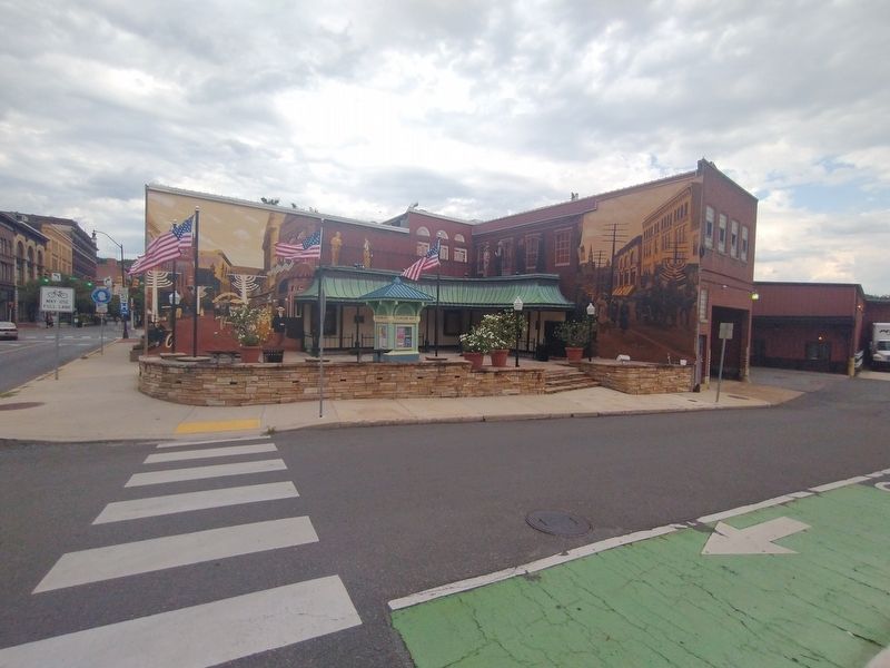
On Baltimore Street at Canal Street, on the right when traveling east on Baltimore Street.
History Of The Fort
Little does the casual observer today realize
that Fort Cumberland once stood on the site
now occupied by the Emmanuel Episcopal
Church. In the 1750's, this fort was a focal
point for the opening battles of the final . . . — — Map (db m204084) HM
On Washington Street at Prospect Square, on the left when traveling west on Washington Street.
Center Plaque
On October 16, 1794, President George Washington arrived in Cumberland to review about 5,000 troops of the Maryland and Virginia militia gathered here during th Whiskey Rebellion. A few days later, this militia army assembled upon . . . — — Map (db m17456) HM
Land for this park was donated to the city in 1893. The park formerly included the site of the bridge approached to your right and an area extending along the river bank upstream. Then, there were extensive walkways, benches, flowerbeds, a viewing . . . — — Map (db m17711) HM
The store houses of The Ohio Company were first located near this point. In 1754 the first fort (called Mt. Pleasant) was built. Gen'l. Edward Braddock enlarged the fort in 1755 and renamed it after his friend the Duke of Cumberland. — — Map (db m167130) HM
On East Oldtown Road at Race Street, on the left when traveling east on East Oldtown Road.
Commemorating the 100th anniversary of St. Mary's Parish Cumberland, Maryland
A.D. 1900-2000
In praise of Mary of the Immaculate
Conception honoring all members of St. Mary's Parish-past, present, and future
This pin oak was planted near the . . . — — Map (db m178116) HM
The First National Bank and Trust Company of Western Maryland was originally chartered as the Cumberland Bank of Alleghany by an act of the 1811 Maryland Legislature and opened for business April 1, 1812. this is the oldest bank in Western . . . — — Map (db m19337) HM
On Washington Street just east of Prospect Square, on the right when traveling east.
You stand near the wall of one of Fort Cumberland's four bastions. These (+) an your position (X) are indicated on the fort diagram. A bastion is a projecting portion of a fortification. It's purpose is to allow defenders added firepower along the . . . — — Map (db m139103) HM
On Washington Street at Prospect Square, on the right when traveling west on Washington Street.
The fort proper was the bastioned work at the west end of the fort. It was to your left (primarily on the site of the Church of Christ Scientist). Besides the four bastions (b) and the joining walls, there were four buildings for provisions (6), two . . . — — Map (db m167356) HM
On National Highway (U.S. 40), on the right when traveling north. Reported permanently removed.
At first, the National Road climbed west from Cumberland up and over Haystack Mountain. In the 1830s, when the road was rebuilt, a new route was chosen. It would be a mile longer but the grade was substantially decreased so that horse teams could . . . — — Map (db m4926) HM
On Baltimore Street at Canal Street, on the left when traveling west on Baltimore Street.
This great water - gap was discovered in 1755 by Lt. Spendelow, a naval officer with the ill - fated Braddock expedition. Cut by the stream now known as Wills Creek, widened by ages of frost and rain, and plunging down over 900 feet from the top of . . . — — Map (db m174246) HM
Near National Highway (Alternate U.S. 40), on the left when traveling north.
The Narrows is a 1000-foot high natural landmark which cuts through Wills and Haystack Mountains. The pass facilitated commerce, travel and migration between Cumberland and the west.
Early roads bypassed the Narrows and followed the Delaware . . . — — Map (db m175915) HM
On National Highway Southwest (Alternate U.S. 40) 0.4 miles north of North Mechanic Street, on the right when traveling north.
At first, the National Road climbed west from Cumberland up and over Haystack Mountain. In the 1830s, when the road was rebuilt, a new route was chosen. It would be a mile longer but the grade was substantially decreased so that horse teams could . . . — — Map (db m243570) HM
The National Pike was also called the National Road (used national funds) or the Cumberland Road (began in Cumberland). Behind you and to the right along the base of the hill, were the storehouses of The Ohio Company. The earliest trails were made . . . — — Map (db m167058) HM
On Washington St. at Prospect Square, on the left when traveling west on Washington St..
Here the Indian envoys were received before Braddock left for his defeat. In 1756-58 the garrison under Col. Washington was still reviewed here. — — Map (db m17453) HM
Which was built in 1755 by order of the British Government and named in honor of the Duke of Cumberland, Captain General of the British Army. It was the base of military operations of General Edward Braddock and Colonel George Washington in the . . . — — Map (db m18733) HM
Near Fayette Street at Tilghman Avenue, on the right when traveling west.
To The Unknown Confederate Dead
Erected by the Ladies of Cumberland, Maryland in 1912 to the heroes who died fighting for the lost cause. — — Map (db m165529) HM
On Bedford Street, 0.2 miles south of Linden Street, on the right when traveling south.
Built by Old German Lutherians
now owned by
First Christian Congregation
Clock awarded by town in contest
National Register of Historic Places — — Map (db m219219) HM
Trenches and Tunnels It was common for forts of this period to have rifle pits or trenches outside the walls as a line of first defense. Fort Cumberland was likely no exception. However, the excavations most people refer to apparently had other . . . — — Map (db m17684) HM
On South Centre Street just south of West Harrison Street, on the left when traveling north.
A memorial to all,
living and dead,
who have served
in our nation's
Armed Forces.
They are not lost who fought and fell.
...they only wait ahead — — Map (db m139117) WM
Near Willowbrook Road (Maryland Route 639) north of Williams Road (Maryland Route 639), on the right when traveling north.
These flags are dedicated with
appreciation to the men and
women of Allegany College of
Maryland, past, present, and
future, who honorably serve
their country, at home and
throughout the world, during
war and peace in the Armed
Forces of . . . — — Map (db m175986) WM
On North Centre Street, on the right when traveling north.
To all
who visit the
Centre Street Parklet.
Originally known
as "Maze” Parklet,
this public space was
created in 1976.
In 2018,
the storefront from
the Malamphy Tavern
that formerly stood at
the corner of Park and
Williams Street . . . — — Map (db m204088) HM
Opened July 1913
National Register of Historic Places
Listed June 1973
Presented by Preservation Society of Allegany County
September 1987 — — Map (db m60547) HM
On Greene Street at Bridge Street on Greene Street.
You are standing at the starting point of this country's first federal road building project, the National Road. A vision of George Washington as a means to develop the continent and to unite the country, his idea was championed by Thomas . . . — — Map (db m17716) HM
On Columbia Street, 0.1 miles west of Polk Street, on the right when traveling west.
Wright Butler House
has been placed on the
National Register
of Historic Places
by the United States
Department of the Interior
c. 1896
— — Map (db m139114) HM
By order of Colonel Bouquet, George Washington’s troops opened this road from Fort Cumberland to Reas-town (Bedford, Pa.) during July 1758. Bouquet and Washington conferred half-way between these places July 30, 1758. — — Map (db m166865) HM
On Ellerslie Road (Maryland Route 35) at Veterans Row, on the left when traveling north on Ellerslie Road.
In memory of our service men who lost
their lives in line of duty and to honor those who served in our Armed Forces
Sgt Jesse Larue USAF • Msgt Emmett Cook USMC • Pvt Harry Airesman USA • Pvt Earl Clites USA • Pvt Russell Devore USA • Pvt John . . . — — Map (db m176159) WM
On Historic National Road (Maryland Route 144) 0.2 miles east of Murley's Branch Road, on the right when traveling east.
War path of the five nations from central New York to the Carolinas. One of the longest Indian trails in America, crossed this highway about this point. — — Map (db m3489) HM
Eons ago, before there was a lake and dam that filled the valley, an ancient stream flowed through from the north. Now known as Rock Gap Run, it slowly cut through the rising sandstone bedrock that eventually became Evitts Mountain.
The . . . — — Map (db m95908) HM
This site is believed to be the homesite and final resting place of Mr. Evart (Evitt) who, reportedly, was the first white settler in Allegany County.
He came here in the early 1700's to escape civilization and live as a hermit.
The . . . — — Map (db m95688) HM
On Headquarters Drive, 0.2 miles west of M. V. Smith Road NE, on the left when traveling west.
Recognizing his contributions
to forest conservation and
historic preservation at
Green Ridge State Forest
25 years of state service 1971-1996
Forest Manager 1975-1988
Author of The Land of the Living
Championed the development . . . — — Map (db m95917) HM
Near Lake Shore Drive north of Exit 50 (Interstate 68).
Before the park was developed
in 1974, this valley was rich with farmland and timber. Seven
farms worked the soil and grew corn,
winter wheat and rye. Two of the farms raised dairy cows. The Raines family farm had approximately 189 acres and had . . . — — Map (db m99149) HM
On Headquarters Drive, 0.3 miles west of M. V. Smith Road NE, on the right when traveling west.
Log Roll Overlook offers the hiker an enjoyable westward view of the Town Creek watershed and a view of three states. The overlook was named for logs that were rolled down the steep mountain slope in the late 1800s, to a sawmill on Town Creek. . . . — — Map (db m95911) HM
On Headquarters Drive, 0.3 miles west of M. V. Smith Road NE, on the right when traveling west.
Long Pond Trail follows the 15-Mile Creek stream valley. This trail winds over ridges and valleys with several steep ascents and descents. These features make it one of the most challenging trails at Green Ridge State Forest.
The trail is named . . . — — Map (db m95916) HM
The National Road enjoyed a revival from about 1910-1960, with the rising popularity of the automobile. Tourist travel began in earnest when cars became reliable enough for the average person to take a long trip. “Waysiders,” people who catered to . . . — — Map (db m4922) HM
On 15 Mile Creek Road Southeast north of National Pike Northeast, on the left when traveling north.
During the Civil War, retribution by one side for "atrocities" committed against civilian by the other quickly escalated. Confederate Gen. Jubal A. Early, during his 1864 Maryland invasion, demanded that several towns pay "ransoms" or be . . . — — Map (db m134413) HM
On Mountain Road, 0.2 miles south of National Pike Northeast (Scenic U.S. 40), on the right when traveling north.
50 acres, purchased December 13, 1930, from Perry Barnes and wife; from Hunter's License Fund for the purpose of propagating game. — — Map (db m199926) HM
On Headquarters Drive, 0.2 miles west of M. V. Smith Road NE, on the right when traveling west.
Pine Lick Trail is connected to landmarks of national historic significance.
THE MASON-DIXON LINE marks the border between Maryland and Pennsylvania, as well as the northern edge of Green Ridge State Forest. Completed in the 1760s, this 230-mile . . . — — Map (db m95909) HM
In 1970, this dam was constructed by the Army Corps of Engineers to impound Rocky Gap Run and create Lake Habeeb. The 243-acre lake is named in honor of Edward Habeeb who inspired the establishment of Rocky Gap State Park.
This lake is . . . — — Map (db m95907) HM
On Headquarters Drive, 0.3 miles west of M. V. Smith Road NE, on the right when traveling west.
This trail allows the hiker to experience Green Ridge State Forest in miniature. The trail follows ridges and valleys along mountain streams and crosses open fields. One section of the trail opens up into an expansive view of Town Hill and the . . . — — Map (db m95913) HM
On National Pike Northeast (Maryland Route 144) at Black Valley Road on National Pike Northeast.
A memorial to our veterans
both living and dead
who served in the Armed Forces
of the United States
In honor of SPL 4 Donald Klinton
awarded the bronze star with V Device
for heroism 1967
Killed Mar. 25, 1968 while serving
with . . . — — Map (db m134412) WM
On East College Avenue just west of Alley 35, on the left when traveling west.
In 1927, construction began for an auditorium-gymnasium and central heating plant. This building was officially named Allegany Hall in 1951 in honor of the institution's host county, and was eventually incorporated into the Guild Center complex in . . . — — Map (db m199903) HM
Near Center Street north of American Avenue, on the left when traveling north.
In 1957 Wendell D. Allen Residence Hall for men was completed. This building was named for the member of the State Board of Education who served in 1935, 1942, 1949, and 1956, and served as Board President 1952 - 1957. — — Map (db m134380) HM
On Historic National Road (Alternate U.S. 40), on the left when traveling west. Reported missing.
“We this day passed the ‘Aligany’ Mountain (Big Savage Mountain) which is a rocky ascent of more than two miles, in many places extremely steep…”
Captain Robert Orme, June 15, 1755
British General Edward Braddock led a 2,100-man army . . . — — Map (db m177978) HM
The Braddock Stone, an early colonial highway marker, is named for British General Edward Braddock (1695—1755). During the early stages of the French and Indian War, General Braddock was dispatched to expel French forces from what is today . . . — — Map (db m135549) HM
Near Park Avenue at Center Street, on the left when traveling north.
In 1965, Brady Health Center was completed. This building was named for Angela Brady, graduate of State Normal School #2 at Frostburg and faculty member for 30 years. — — Map (db m152822) HM
On New Hope Road, 0.2 miles north of Depot Stret, on the right when traveling north.
Bituminous coal had been discovered in what is now Allegany County before the French and Indian War. Although farmers worked small individual diggings prior to the Nineteenth Century, it would not be until about 1820 that coal obtained some degree . . . — — Map (db m96387) HM
Near East College Avenue west of Wood Street, on the left when traveling west.
In 1963, Cook chapel was completed. It was located in the former dining room of Frost Hall and named for Carrie Edith Ricketts Cook, an English Instructor, who taught from 1925 to 1937. — — Map (db m134384) HM
As seen on the right, the Cumberland and Pennsylvania Railroad Depot at Frostburg was constructed in 1891. The depot served as a passenger and freight station enroute between Cumberland, Maryland down the rich coal-mining region of Georges Creek to . . . — — Map (db m48853) HM
Near University Drive south of Planetarium Drive, on the left when traveling south.
In 1970, Dunkle Hall was completed. This building was named for John L. Dunkle, Principal and President of Normal School #2 at Frostburg State Teachers College from 1923 - 1944. — — Map (db m134528) HM
Near Braddock Street (Maryland Route 736) west of Park Avenue, on the right when traveling west.
In 1978, the Administration Building opened. This building was dedicated in 1982 as the Elisabeth Hitchens Administration building to honor a 40-year employee of the College. Hitchins was the institution's first registrar (1934) and the first . . . — — Map (db m134389) HM
On Environmental Drive north of Planetarium Drive, on the left when traveling north.
In 1965, the Jerome Frampton, Jr., library was completed. This building was named for the President of the State Board of Education. — — Map (db m134527) HM
On East Main Street (Alternate U.S. 40) east of Broadway.
This monument, erected in 1877, marks the graves of Meshach Frost (1787–1864) and his wife Catherine (1792–1876), founders of Frostburg. In 1812 they built their first home here. As the tavern Highland Hall, the building later . . . — — Map (db m3550) HM
On East College Avenue west of Wood Street, on the left when traveling west.
In 1919, Frost Hall opened. Named for Catherine Frost, the daughter-in-law of the founder of Frostburg, this was the first residence hall and was designated for Women. — — Map (db m134386) HM
On East Main Street (Alternate U.S. 40) east of Broadway, on the left when traveling east. Reported permanently removed.
Years before St. Michael’s Church was built,
Meshach Frost and his wife Catherine purchased
this property in 1812. When the Frosts bought the
property, construction of the National Road was
already underway. They soon found they were
feeding . . . — — Map (db m3551) HM
On East Main Street west of Water Street, on the right when traveling east. Reported permanently removed.
The National Road has sustained Frostburg
for almost two centuries. As the road was
being surveyed in 1811, Josiah Frost began
laying out lots. Businesses, serving passing
stagecoaches and wagons, soon lined a
developing Main Street.
By . . . — — Map (db m3553) HM
On New Hope Road, 0.2 miles north of Depot Street, on the right.
Frostburg can trace its history back to the very early 1800s, when the community was known as Mt. Pleasant and consisted of only three homes. By the time the National Road opened through in 1812, an early settler named Josiah Frost had lain off the . . . — — Map (db m96388) HM
On New Hope Road, 0.2 miles north of Depot Street, on the right.
Established: 1812
Elevation: 1820'
Population: 9,002
County: Allegany
Situated in the headwaters of the Georges Creek basin, Frostburg was settled in the early 1800's and served as a traveler's stop along the newly constructed National . . . — — Map (db m96390) HM
On West Main Street (U.S. 40) west of South Water Street, on the left when traveling west.
The National Road has sustained Frostburg for almost two centuries. As the road was being surveyed in 1811, Josiah Frost began laying out lots. Businesses, serving passing stagecoaches and wagons, soon lined a developing Main Street.
By the . . . — — Map (db m199906) HM
On East Main Street (Alternate U.S. 40) 0.1 miles west of Depot Trace, on the right when traveling west.
Years before St. Michael's Church was built, Meshach Frost and his wife Catherine purchased this property in 1812. When the Frosts bought the property, construction of the National Road was already underway. They soon found they were feeding and . . . — — Map (db m199913) HM
On Braddock Street (Maryland Route 736) west of Park Avenue, on the right when traveling west.
In 1968, Fuller House was acquired by the college. This building is the former residence of William Fuller, grandson of one of Old Main's builders. — — Map (db m134387) HM
On New Georges Creek Road (Maryland Route 36) at Hoffman Hollow Road, on the right when traveling north on New Georges Creek Road.
During colonial exploration and settlement the valley provided a route to the western frontier. In 1753, preceding the French and Indian War, George Washington traveled this route to deliver Gov. Dinwiddie's order that the French abandon their . . . — — Map (db m84736) HM
Near Environmental Drive north of Planetarium Drive, on the right when traveling north.
In 1960, Gunter Hall opened as the new student center. Named for William A. Gunter, local attorney and former president of both the State Board of College Trustees and State Board of Education, this building originally housed a dining hall, snack . . . — — Map (db m134378) HM
Near St. John's Rock Road, 0.5 miles south of Beall School Road.
The following was taken from the journal of Robert Orme, aid de camp to General Braddock - June 15, 1755: We this day (with 2100 troops, 1500 hundred horses, 200 wagons and twelve cannons) passed the Allegany Mountains, which is a rocky ascent of . . . — — Map (db m166921) HM
Near East College Avenue at Wood Street, on the right when traveling east.
Near this spot, a vibrant African American neighborhood existed prior to the construction of the Frostburg State University campus.
The name and spirit of Brownsville emerged in the late 19th century largely due to the courage and dedication . . . — — Map (db m199904) HM
On West Main Street (Alternate U.S. 40) at South Water Street (Maryland Route 36), on the right when traveling west on West Main Street.
KOREA
1950 - 1955
Thomas A. Dickey • William L. Geary • William R.Jackson • John L. McKenzie • David McKinley • James G. Moran • James W. Rafferty • William R. Seggie • Joseph M. Shannon • Robert E. Shannon • Paul T. Smith • Francis D. Thomas . . . — — Map (db m176728) WM
On Main Street (Alternate U.S. 40) at South Water Street (Maryland Route 36), on the right when traveling west on Main Street.
William Andres • Arthur M. Arnone • Kinney E. Baxter • David Beck • Noah Beeman • Evan Boyer • Darby J. Brady • William P. Brady • John B.Brodbeck • Robert C. Brown • John J. Canning • George Chaney • E. Walker Chapman • Kenneth W. De Vault • . . . — — Map (db m177426) WM
On Main Street (Alternate U.S. 40) at South Water Street (Maryland Route 36), on the right when traveling west on Main Street.
April 6, 1917 - November 11, 1918
Melvin V. Albright • Edward Barry • Thomas Barry • Richard Beall • Edward Britt • Lawrence Campbell • Samuel Campbell • James L. Carson • John R. Fairgrieve • Hugh Farrady • John Farrady • David Hansel • L.G.R. . . . — — Map (db m177427) WM
7476 entries matched your criteria. Entries 101 through 200 are listed above. ⊲ Previous 100 — Next 100 ⊳