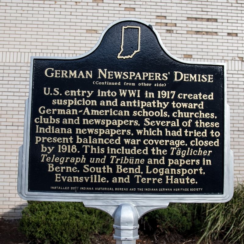
On Delaware Street north of East Maryland Street and Virginia Avenue, on the right when traveling north.
German-language newspapers
thrived as Germans became Indiana’s
largest immigrant population by 1850.
The Täglicher Telegraph und Tribüne,
located near here, was among over
175 German-language newspapers
published in Indiana, . . . — — Map (db m128027) HM
On West Michigan Street at North Fulton Avenue, on the right when traveling east on West Michigan Street.
The first demographic waves of German immigrants occurred in the 1680s when they settled in Pennsylvania. In the nineteenth century, Germans continued to come to America in waves. Quite a few settled in this area between 1836 and 1840. The most . . . — — Map (db m226796) HM
On North Pennsylvania Street north of East North Street, on the right when traveling south.
A World at War
History records that World War II began in earnest on September 1, 1939, when German troops invaded Poland. Treaty allies Great Britain and France declared war on Germany. Italy, already branded an aggressor for its campaign . . . — — Map (db m132860) WM
Dedicated to the men who gave their lives
in service to our country during World War II
Africa, Pantelleria, Sicily, Italy,
India, China and Burma
Fire from the Clouds — — Map (db m163765) WM
Near River Road east of Old Street, on the left when traveling south.
As useful as Munfordville's small ferry was, it couldn't meet the needs of whole armies. As soon as General Alexander McDowell McCook's army arrived at Green River in the fall of 1861, soldiers immediately began building flat-bottomed boats to . . . — — Map (db m40019) HM
Near Baxter Avenue (U.S. 31E/150) at Cherokee Road, on the right when traveling north.
The Battle of Rowlett's Station
On December 17, 1861, the 32nd Indiana Infantry (nicknamed the "1st German” regiment as it consisted entirely of German immigrants) engaged Confederate forces near Munfordville, Kentucky, in the Battle of . . . — — Map (db m245364) HM
Near Baxter Avenue at Payne Street, on the right when traveling north.
The 32nd Indiana at the Battle of Rowletts Station
On December 17, 1861, the "1st German" 32nd Indiana Volunteer Infantry Regiment, commanded by Colonel August Willich, fought Confederate cavalry, infantry and artillery units south of . . . — — Map (db m29483) HM
Near Indian River Drive at Harrison Street, on the right when traveling south.
USAT Dorchester
The Dorchester was a 5,649 ton civilian cruise ship, 368 feet long with a 52-foot beam and a single funnel originally built in 1926 by Newport News Shipbuilding and Dry Dock Company, for the . . . — — Map (db m288653) HM WM
Near East Lutheran Church Road west of South Grimes Road.
Organized in 1832 by German speaking families of the Evangelical Lutheran Church of Rowen County, North Carolina. Migrating to Indiana in 1828. August 7, 1836 Jacob and Elizabeth Linebaugh Bowman deeded land for the First Church and Cemetery. — — Map (db m10027) HM
Near West Main Street (U.S. 31W) at North 9th Street, on the right when traveling west.
[Originally written in German, the inscription transcribed into English, reads:]
Here lie men of the 32nd First German Indiana Regiment sacrificed for the free Institutions of the Republic of the United States of North America. . . . — — Map (db m174948) HM
On East Michigan Avenue (Business Interstate 94) near South Kalamazoo Mall, on the left when traveling east.
Development began in the Haymarket district as early as the 1830s and was spurred by the construction of the Grand Rapids and Indiana Railroad Depot in 1870. The district became a hub for retail, wholesaling and light manufacturing. It was the . . . — — Map (db m190213) HM
On East Michigan Avenue (Business Interstate 94) near South Edwards Street, on the right when traveling east.
Development began in the Haymarket district as early as the 1830s and was spurred by the construction of the Grand Rapids and Indiana Railroad Depot in 1870. The district became a hub for retail, wholesaling and light manufacturing. It was the . . . — — Map (db m190214) HM
On Main Street at Mercer Street, on the right when traveling north on Main Street.
First home of Harmony Society, founded 1804, by George Rapp and German followers. In 1814 moved to New Harmony, Indiana, and settled at Economy in present Ambridge, Beaver County, in 1825. — — Map (db m40359) HM
On West Baden Avenue just west of Broadway Street (Indiana Route 56), on the right when traveling west.
The entrance of West Baden Springs Hotel features a double archway and serves as a gateway to the magnificent hotel. The International Steel and Iron Company was awarded the contract for the construction in 1902. The archway was actually . . . — — Map (db m195090) HM
On Main Street north of Mozart Street, on the right when traveling north.
In the early 1800s, the Ohio River was the font of Midwestern settlement. Easy river travel helped spur colonization. German speaking Swiss people were among the many ethnic groups who migrated to America seeking economic opportunity and freedom . . . — — Map (db m47526) HM
On Stingley Road (County Route 57) 0.2 miles west of Smith Road (County Route 386), on the left when traveling west.
James and Sophia Clemens’ lives are part of a story of tens of thousands of people of color who migrated north in search of land to farm and better lives during the first half of the 19th century. In 1818, James Clemens (1781-1870) purchased 387 . . . — — Map (db m168860) HM
Near Shingle Road 0.1 miles north of Military Road when traveling north.
Tablet #1 Union Batteries 7th Indiana (Sec) Lt. Otho H. Morgan Baird Mouth Chatta. Creek 10th Indiana Capt. Wm. A. Naylor Sheridan Moccasin Point 1st Iowa Lt. James M. Williams Osterhaus W. of Lookout Creek 2d Missouri . . . — — Map (db m35750) HM
On University Boulevard south of West New York Street, on the left when traveling south.
The Normal College, now incorporated into IUPUI’s School of Health and Human Sciences, was the oldest continuously operating physical training school in the country. Founded by German immigrants, the school first opened in New York in 1866, moving . . . — — Map (db m231635) HM
On South Meridian Street south of East Maryland Street.
German immigrant and hardware merchant John H. Vajen constructed his commercial building on 124-126 North Pennsylvania Street in 1872. This building featured a three-story, cast-iron facade in the popular Italianate style. It housed retail shops and . . . — — Map (db m132811) HM
On US Highway 136 (U.S. 136) at Road 5600, on the left when traveling west on US Highway 136.
Located three miles north of this corner, near the Little Blue River, the village of Friedensau ("Peaceful Meadows") was established in 1874 by Lutheran missionary pastor John J. Kern. The town was first settled by his former parishioners from . . . — — Map (db m85667) HM
On South Hall Street at East Bradley Street, on the right when traveling north on South Hall Street.
German native Fridolin (Fred) Fischer (1850-1921) came to Freestone County from Indiana in 1876. In 1893, the same year he opened a local hardware store, he had this home constructed by David P. Winfrey. Built in the Eastlake style, the residence . . . — — Map (db m85009) HM
On Crowsnest Highway (Provincial Highway 3) 0.8 kilometers west of Range Road 195, on the right when traveling west.
Mennonites have been moving to Alberta for well over a century. Mennonite settlement stretches back to 1894 when Mennonites from Waterloo County, Ontario, established a settlement at Didsbury. Didsbury’s first building was a narrow log immigrant . . . — — Map (db m201774) HM
On Prospect Street just east of South Alabama Street, on the right when traveling west.
The South Side Turnverein, an athletic and social club founded in 1893, fostered German cultural traditions in Indianapolis. It promoted the Turner philosophy of integrated mind and body wellness and expanded under the leadership of German . . . — — Map (db m238584) HM
On Lincoln Highway (U.S. 33) at East State Street (Indiana Route 205), on the left when traveling north on Lincoln Highway.
Shortly after the town's founding an application was made to the postal authorities at Washington for a post office under the name "Franklin".
It was refused because a Franklin post office already existed in Indiana and the department would . . . — — Map (db m174726) HM
On West Main Street (U.S. 40) west of Pearl Street, on the right when traveling west.
They traveled West by horse and wagon, oxen and Conestoga, and by foot. They represented a staggering assortment of crafts, talents and trades. They emigrated from Germany in search of affordable land, economic opportunity, and political and . . . — — Map (db m152530) HM
Near N. Arnott Street (County Road 3) at W. Market Street (U.S. 6), on the right when traveling north.
Amish pioneer Christian Stahly purchased this 80 acre farm for his son Moses in 1873. The year before the village of Nappanee was established on the new northern route of the B&O Railroad. Three generations of related Amish families have lived here. . . . — — Map (db m74075) HM
On East Market Street at State Street, on the right when traveling east on East Market Street.
In 1813 John Graham surveyed and platted a town which the Scribner brothers, founders of the town, named New Albany after Albany, New York. Within five years, the new community became the seat of the newly formed Floyd County. Boat building and . . . — — Map (db m194200) HM
On Wabash Street at West 10th Street, on the right when traveling south on Wabash Street.
One of the most striking features of the Haskell & Barker Historic District is the number of large churches with tall spires that include St. Mary's Catholic Church, St. Stanislaus Catholic Church, the First Congregational Church, and the First . . . — — Map (db m292860) HM
On South East Street at Prospect Street, on the right when traveling north on South East Street.
Pharmacist John A. Hook opened his first drug store here in 1900. Hook, the son of German immigrants, graduated from pharmacy college and served the Fountain Square neighborhood with his “Deutsche Apotheke” until 1919. The building was razed in . . . — — Map (db m210965) HM
On Massachusetts Avenue north of East St. Clair Street, on the right when traveling north.
German immigrant William P. Jungclaus established a general contracting firm in Indianapolis with family in the 1870s. In 1895, he incorporated the William P. Jungclaus Co. as its successor and opened its headquarters and mill site here. The . . . — — Map (db m303424) HM
On South East Street at South Stevens Street on South East Street.
Platted 1854; now bounded by South East Street, Virginia Avenue, and interstates 65/70. Early residents were Germans, Irish, Scots, and Welsh. Danes resided in area circa 1870–1890. By 1910, ninety percent of area residents were Italian . . . — — Map (db m1839) HM
On Indian Street at 6th Street, on the left when traveling west on Indian Street.
The first homestead claim in Howard County was filed on March 11, 1871. St. Paul was appointed the county seat in May, and retained that title over Dannebrog in a close 1874 election. A wooden courthouse was built in St. Paul in 1877. By June 1912, . . . — — Map (db m181691) HM
On Main Street at West Front Street, on the left when traveling east on Main Street.
German natives F.W. (Fritz) and Carolyn (Krampitz) Hackbarth arrived in Galveston in 1846 with their two sons. They settled in Austin County, where Fritz farmed and ranched, and the couple had four more children, including F.W. Hackbarth, Jr. . . . — — Map (db m162567) HM
On Crockett Drive south of Memorial Park Drive, on the right when traveling north.
Roy Eldon "Buck" White was born in Brownwood on 28 February 1900. He changed his date of birth so he could enlist in the Navy on 20 April 1917 when he was only 17 years old. Fireman Second Class White was on the USS Alcedo when it was sunk by a . . . — — Map (db m247848) HM WM
Born in New York City to German immigrants Nicholas and Margaretta Heiner, Eugene Thomas Heiner apprenticed himself to a Chicago architect when he was thirteen years old and later completed his training in Berlin, Germany. Heiner became a draftsman . . . — — Map (db m122983) HM
In early twentieth century Robstown, German and Moravian families migrated to this area to farm. Czech-speaking Catholics could not find any places of worship that could provide spiritual services in their native language. Father Joseph Klobouk . . . — — Map (db m211536) HM
On Government Street (U.S. 90) at Espejo Street, on the right when traveling west on Government Street.
Grace is the first Lutheran congregation in the State of Alabama. Organized by German immigrants, the first service was held on October 6, 1867 in the Seaman's Bethel in Mobile. The first Pastor was Theodore Heischmann. The name chosen for the . . . — — Map (db m149320) HM
Near West North Washington Street at North Charles Street, on the right when traveling east.
A New Spiritual Anchor at Canal Park
During the 1830s and 40s the Canal
transformed this region into a new cultural
and economic entity. This new era propelled
a now confident Delphi into the mid and late
19th century. It was now ready . . . — — Map (db m163314) HM
Near S. Main Street (State Road 15) at River Vista Drive, on the right when traveling north.
The folk lore concerning this cemetery has been handed down through generations by word of mouth. Most of it has proved to be factual through the efforts of Gordon Treesh, who researched old records and diaries.
This is not a family cemetery, . . . — — Map (db m74217) HM
On Main Street at Main Street, on the right when traveling west on Main Street.
Bavarian Jewish immigrants Adam and Solomon Gimbel worked as peddlers before establishing a dry goods and clothing store here by 1848. Regular advertising and quality goods drew customers, and the business prospered. The company moved to . . . — — Map (db m272751) HM
On Bluff Road at W. Hanna Avenue, on the right when traveling north on Bluff Road.
(Front Side)
Many of Indiana's German immigrants settled in southwestern Marion County during the mid-1800s and began greenhouses and truck gardens on Bluff Road; area grew to major boundaries of Harding, Raymond, Madison, and Banta . . . — — Map (db m67188) HM
On Saint Louis J Koch Boulevard at West Christmas Boulevard (Indiana Route 162), on the left when traveling south on Saint Louis J Koch Boulevard.
"In 1854, German Immigrants settled into a rural area of Indiana they named Santa Fe. When the community applied for a post office, their application was rejected because there was already a Santa Fe, Indiana. The Santa Claus, Indiana Post Office . . . — — Map (db m286719) HM
On Kaspar Drive at West Christmas Boulevard (Indiana Route 162), on the left when traveling north on Kaspar Drive.
"In 1854, German Immigrants settled into a rural area of Indiana they named Santa Fe. When the community applied for a post office, their application was rejected because there was already a Santa Fe, Indiana. The Santa Claus, Indiana Post Office . . . — — Map (db m286723) HM
On North Niles Avenue 0.1 miles north of Cedar Street, on the left when traveling north.
Hebrew Society of Brotherly Love of South Bend established Jewish cemetery on this site 1859. First Jewish families settling in a new community typically organized a burial society before establishing a formal congregation. Before Civil War era, . . . — — Map (db m2759) HM
On Ferry Street at Franklin Street, on the right when traveling south on Ferry Street.
As soon as immigrant James Dufour saw the area now known as Vevay in the Northwest Territory, he knew it would be an ideal place for his vineyards. The gentle hills were terraced like those in his native district of Vevay, Switzerland, and he named . . . — — Map (db m223349) HM
On Lincoln Highway (U.S. 30) at Sherwood Avenue (Arizona Street), on the right when traveling west on Lincoln Highway.
[south side]Glidden bookends the World Wars with Merle Hay & Enola Gay [north side]Joseph Glidden Inventor of modern barbed wire Donald Sparks • POW☆MIA [west side]Medal of . . . — — Map (db m285858) HM
On Lincoln Highway (U.S. 30) 0.4 miles west of Sherwood Avenue (Arizona Street), on the right when traveling west.
Private Merle D. Hay, a native of Glidden, Iowa, was one of the first three American soldiers killed in action during World War 1. He was posthumously awarded the Silver Star for valor by the Commanding General, 1st Division, for his heroic actions . . . — — Map (db m285867) HM
Near Kentucky Route 235 0.1 miles south of Route 761, on the left when traveling south. Reported permanently removed.
"If it gets too hot for you, shut your eyes my boys - forward!" - Major Gustave Kammerling, 9th Ohio (photo inset) Union Colonel Robert McCook, commanding the Union 3rd Brigade ordered one of the few successful bayonet charges of the Civil . . . — — Map (db m62973) HM
On Vine Avenue West just east of 3rd Street Southwest, on the right when traveling east.
To the memory of Reverend Emil Polášekwho for thirty-two years, from 1905 to 1937, served God as a pastor of The Church of the Holy Redeemer, rejoicing with us in our joys, comforting us in our sorrows, exhorting us by word of mouth . . . — — Map (db m212945) HM
Donald Kyler was sixteen years of age when he enlisted in the Regular Army in April of 1917. A native of Whitley County, Indiana, he grew up on a farm and in the small town of Collamer. With the consent of one of his family, he enlisted at Fort . . . — — Map (db m104048) HM
On County Road 44 0.3 miles east of County Road 7, on the left when traveling east.
Bull Cemetery
Established circa 1848
A Historic Cemetery Listed in Indiana's Cemetery and Burial Grounds Registry of the Indiana Department of Natural Resources
Installed 2009 Indiana Historical Bureau and James G. Hermsen . . . — — Map (db m68576) HM
On South East Street at Virginia Avenue, on the left when traveling south on South East Street. Reported damaged.
German, Irish, Scottish, Danish, and Welsh immigrants moved to this neighborhood starting in the mid-1800s. In the 1890s, Italian families who made their livings selling fruit and vegetables, particularly Sicilians, began to settle in the . . . — — Map (db m303438) HM
On Virginia Avenue just north of East McCarty Street, on the left when traveling north. Reported damaged.
German, Irish, Scottish, Danish, and Welsh immigrants moved to this neighborhood starting in the mid-1800s. In the 1890s, Italian families who made their livings selling fruit and vegetables, particularly Sicilians, began to settle in the . . . — — Map (db m303441) HM
On East South Street at East South Street, on the right when traveling east on East South Street.
Much of this predominantly residential neighborhood was originally “Woodlawn”, the farm of pioneer lawyer and banker Calvin Fletcher. In 1871, the Fletcher Place Methodist Episcopal Church rose at the corner of Fletcher and Virginia Avenues and . . . — — Map (db m303437) HM
On East Michigan Street at North Pennsylvania Street, on the right when traveling west on East Michigan Street.
Originally known as , "Obelisk Square", this park was completed in 1930 and is situated between the American Legion Mall and the Indiana World War Memorial. Its main feature is the Obelisk fountain. This portion of the Plaza was designed originally . . . — — Map (db m132862) HM
Near Army Heritage Trail south of Soldiers Drive, on the right when traveling south.
Donald Kyler was sixteen years of age when he enlisted in the Regular Army in April of 1917. A native of Whitley County, Indiana, he grew up on a farm near the small town of Collamer. With the consent of one of his family, he enlisted at Fort . . . — — Map (db m217213) HM
Near Overlord Circle 0.4 miles west of Burks Hill Road.
Activated on 20 July 1942 at Camp Toccoa, Georgia, the 506th Parachute Infantry Regiment (PIR) came on line under the command of Colonel Robert F. Sink, who remained commander throughout its service. Early in its training near Currahee Mountain in . . . — — Map (db m240607) WM
On Butte Avenue, on the right when traveling north.
The Joint
Ray and Olga Guyett purchased this building in the 1950’s and established The Joint, restaurant and bar. The Joint has been the center of Randsburg’s social life for over forty years and has the distinction of being the longest . . . — — Map (db m53853) HM
Near Rengstorff Avenue 0.1 miles north of Middlefield Road, on the right when traveling north.
This windmill was the very last to stand at its original location in Mountain View — behind the residence at 944 San Leandro Avenue. It was purchased in 1936 from the Geo. W. Sohler & Son Company at 550 California Street. The 8-foot diameter . . . — — Map (db m183428) HM
On Fort Hill Terrace east of Fort Hill Circle, on the left when traveling north.
The Confederate "Army of Tennessee" that defended Dalton from November 1863 to May 1864 briefly returned here the following October. It was much depleted in both size and spirit. Their unsuccessful defense of Atlanta ended with its fall on September . . . — — Map (db m86563) HM
On Park Drive just south of West Main Street, on the right when traveling south.
In the mid 1800s, roughly a quarter-mile east of where you stand, Madison County residents carved a settlement from farm fields, prairie grass, broken forests, and the National Road.
Here, the National Road was little more than a scraped-earth . . . — — Map (db m144106) HM
On Patrol Road south of Trey Street, on the right when traveling south.
Charlestown Indiana in the summer of 1940 was a quiet town with a population of 900. By December of that same year the population had grown to over 13,400. Of this number over 10,000 residents worked at a single plant. The “boom” in Charlestown . . . — — Map (db m206901) HM
On East Valeene Road, on the left when traveling south.
John M. Johnson opened a private
school in Marengo 1869 with 60
students. He designed a course of
study to provide an opportunity
for students to move beyond
common school (elementary)
education. In 1874, Johnson renamed
it Marengo Academy in . . . — — Map (db m264883) HM
On Taft St at W. 10th Ave, on the right when traveling north on Taft St.
St. John's Church, the oldest surviving institution in Gary and north of the Little Calumet River, began with the work of the Rev. Henry Wunder in the early 1860's. He regularly came from Chicago by horse and buggy. Baptism records date from 1863; . . . — — Map (db m200365) HM
On North Meridian Street at East Michigan Street, on the right when traveling west on North Meridian Street.
Originally known as , "Obelisk Square", this park was completed in 1930 and is situated between the American Legion Mall and the Indiana World War Memorial. Its main feature is the Obelisk fountain. This portion of the Plaza was designed originally . . . — — Map (db m132833) HM
On North Pennsylvania Street at East North Street, on the right when traveling south on North Pennsylvania Street.
Originally known as, "Obelisk Square", this park was completed in 1930 and is situated between the American Legion Mall and the Indiana World War Memorial. Its main feature is the Obelisk fountain. This portion of the Plaza was designed . . . — — Map (db m132863) HM
Camp Edwin F. Glenn, named after a former Post Commander, was constructed in 1935. It originally housed the Citizen's Military Training Camp, but served many purposes over time.
Camp Glenn proved successful as a camp within the larger Fort . . . — — Map (db m280267) HM
On Arthur Street north of Church Street, on the left when traveling north.
What is utopia?
Sir Thomas More in 1516 defined it as a place of perfect political and social systems.
Throughout history, people have sought ways to live "in harmony..." So it was that the town of Harmonic, Pennsylvania was established in 1804 . . . — — Map (db m96074) HM
On NW 4th Street at Vine Street, on the right when traveling north on NW 4th Street.
On March 2, 1827, Congress provided a land grant to encourage Indiana to build the Wabash & Erie Canal. The original plan was to link the navigable water of the Maumee with the Wabash through the seven mile portage at Fort Wayne. Work began five . . . — — Map (db m48241) HM
On East Chase Street at North Charles Street on East Chase Street.
In 1903, the Belvedere Hotel became the crowning architectural achievement in the neighborhood. Its signature thirty-five-foot mansard roof has become the symbol for upper Mount Vernon. In the late 1970s, the building was rehabilitated into . . . — — Map (db m102915) HM
Near Dey Street east of N. 5th Street (Michigan Highway 51), on the right when traveling east.
(Obverse Side)
Michigan Central Railroad Depot
This Richardsonian Romanesque-style depot was constructed in 1892 by the Michigan Central Railroad Company. Seeking to create a lasting impression of Michigan for passengers . . . — — Map (db m68480) HM
On Second Street (U.S. 80) east of Goforth Street, on the right when traveling east.
Front
Rubin Lacy was one of the most talented and influential artists in Mississippi blues during his short career as a secular performer. The grandson of a minister, Lacy was born in Pelahatchie on January 2, 1901. He was a well-known . . . — — Map (db m111013) HM
On East Lafayette (Missouri Route 6) just west of North 4th, on the right when traveling west.
Edina, the seat of Knox County, was laid out here in the glacial plains of northeast Missouri, 1839, by W.J. Smallwood. Scotsman S.W.B. Carnegy, who surveyed the new town, named it the poetic form of Edinburgh. The county, formed 1843 and organized . . . — — Map (db m144472) HM
On Cherokee Street west of Indiana Avenue, on the right when traveling east.
The population of the United States and its territories was less than 34 million people in 1860 — and the nation was tearing itself apart along the lines of Free States and those that allowed slavery.
News of impending civil war pushed . . . — — Map (db m124475) HM
On County Route 77 at County Route 366, on the right when traveling north on County Route 77.
The Pioneer Barn is so-called because of its design, not its age. The 48 foot by 36 foot-barn houses the Eash & Yoder Conestoga Wagon and related artifacts of the pioneer era. Using an 1840-era Pennsylvania barn style (also known as German barn . . . — — Map (db m281151) HM
On 5th Avenue Northwest at Skyline Drive, on the right when traveling west on 5th Avenue Northwest.
Arthur C. Mellette was elected first Governor of the State of South Dakota in 1889. Although Watertown lost in its bid to obtain the State Capital, which was established in Pierre, the Mellettes maintained their home in Watertown.
While the . . . — — Map (db m181946) HM
On Hickory Valley Road south of Bonny Oaks Drive, on the right when traveling south. Reported missing.
The Confederate Army of Tennessee occupied Chattanooga in early July, 1863. The Confederates were expecting the pursuing Federal Army of the Cumberland to cross the Tennessee River well above Chattanooga, cut off the Confederate forces at . . . — — Map (db m83072) HM
Near East Springbrook Road east of Lindsay Avenue, on the left when traveling east.
"All good citizens must deplore such a lawless wreaking of vengeance upon the person of an unarmed old man. Such things show how rapidly we are drifting into scenes which must be full of terror for us all." —Rockingham Register, June 24, . . . — — Map (db m304702) HM
On The Embarcadero near Brannan Street, on the right when traveling north.
The Fremont Street Wharf angled 500 feet northeast into the bay from this place from 1869 to 1907. At that time the Alaska Packers; fleet of wooden and iron square rigged ships and barks loaded here, sailing 2,500 miles north to Alaska each spring . . . — — Map (db m92933) HM
On 4th Street Northwest at Indiana Avenue Northwest, on the left when traveling south on 4th Street Northwest.
Welcome to downtown Washington DC - an area rich in history, culture and places to see. You will enjoy visiting the following sites located in the vicinity of this sign.
Clockwise from top:
"Lone Sailor" at the US Navy . . . — — Map (db m110214) HM
On F Street Northwest east of 5th Street Northwest, on the right when traveling east.
Welcome to downtown Washington DC—an area rich in history, culture and places to see.
You will enjoy visiting the following sites located in the vicinity of this sign.
The Courts on Judiciary Square
Judiciary Square is one of the . . . — — Map (db m18439) HM
Near Resaca Lafayette Road Northwest (Georgia Route 136).
Approximately 160,000 men fought on the hills of Resaca. About 7,000 of them died and many, many more were wounded. Some were captured and spent the remainder of the war in either a Confederate or Union prison camp. A few wrote of their experiences. . . . — — Map (db m170996) HM
On East Berry Street, on the right when traveling west.
Construction of the Lincoln Tower began less than
a month before the stock market crash of October
1929 that signaled the beginning of the Great Depression. Completed in November 1930, the 312-foot
Tower was for many years Indiana's tallest . . . — — Map (db m197233) HM
On East Main Street, on the right when traveling east.
In honor of a native son
Samuel Woodfill
Major, United States Army
born near Bryantsburg, Indiana
January 6, 1883
Died Vevay, Indiana
August 10, 1951
Buried in Arlington National
Cemetery
"The outstanding American soldier
in . . . — — Map (db m242693) HM WM
Near Schrage Avenue south of John Street, on the right when traveling south.
Henry Schrage (1844-1932) was born into one of the first families of Whiting. An entrepreneurial spirit, he learned a strong work ethic from his humble beginnings as a German immigrant. Upon returning home after serving in the Union Army in the . . . — — Map (db m256487) HM
On Madison Street at Lincolnway, on the right when traveling south on Madison Street.
Meinrad Rumely
Meinrad Rumely was the founder and guiding spirit of the Rumely Companies for more than 50 years. He came to America from Germany in 1848, and in 1853 on this site opened a blacksmith shop that was to grow into a large . . . — — Map (db m43463) HM
On North Meridian Street at East North Street, on the right when traveling north on North Meridian Street.
Originally known as , "Obelisk Square", this park was completed in 1930 and is situated between the American Legion Mall and the Indiana World War Memorial. Its main feature is the Obelisk fountain. This portion of the Plaza was designed originally . . . — — Map (db m132836) HM
Near Park Road north of Indiana Route 47, on the left when traveling north.
1. As the State's 1916 centennial celebration approached, Lieber put forth the idea of creating a state park system.
Colonel Richard Lieber
"The time has come when Indiana must halt the destruction of the forests, the neglect of . . . — — Map (db m268983) HM
On Indiana 129 0.2 miles east of Detour Road, on the right when traveling east.
This house is one of the few remaining examples of the French colonial architecture that once
characterized the first settlement of Switzerland County. The style was common throughout the
Mississippi Valley. The house was built in 1828 and is a . . . — — Map (db m289222) HM
Near South Dixie Highway (U.S. 31W) 0.1 miles north of L and N Turnpike Road (Kentucky Highway 335), on the left when traveling north.
Organized in Houston in 1861 by Kentucky-born Texas sugar planter Benjamin Franklin Terry, the 8th Texas Cavalry would be better know throughout the Civil War as “Terry’s Texas Rangers”—though Terry was himself among the first casualties in the . . . — — Map (db m250221) HM
On E. 4th Street, on the right when traveling east.
This is an "Improved" German Krupp designed 75mm field gun built in 1910 in the historic Japanese village of Shikano on the Sea of Japan under Osaka Arsenal's control. It is one of 2,900 built and one of only thirty-three in existence presently . . . — — Map (db m241281) HM WM
On Mercer Street at Seneca Drive, on the right when traveling south on Mercer Street.
[Top left painting caption reads] George Washington in his Virginia Regiment uniform. Painting by Charles Willson Peale
On November 30, 1753, 21-year-old George Washington, a major in the Virginia Regiment, camped . . . — — Map (db m244472) HM
On East Union Street at Merchants Alley, on the right when traveling west on East Union Street.
The "Last Purchase” land became Pennsylvania counties. Jefferson County was officially designated in 1806. Rev.
David Barclay and his son-in-law John W. Jenks purchased the land about 1818. In 1821 David Barclay recorded the town site with the . . . — — Map (db m306147) HM
Near Point Park Road 0.1 miles north of East Brow Road.
[Text from the outer plaque facing north]:
On Nov. 23, 1863, Maj. Gen. Hooker was directed to make a demonstration early the following morning on the Point of Lookout Mountain with the troops in Lookout Valley under his command, . . . — — Map (db m23954) HM WM
On West 18th Street at Baynard Boulevard on West 18th Street.
African American Medal of Honor Recipients Memorial
The Medal of Honor takes its place in our country as the highest award for military valor. The honor, awarded by the President in the name of Congress, may only be accorded an . . . — — Map (db m173924) HM WM
On East Bay Street south of Rossiter Place, on the left when traveling east.
On the front, south side is inscribed:
Dedicate May 4, 1986
To honor the members of the
Chatham Artillery
Servants of God, Country,
State and Community
—
Soldiers in War
Patriots in Peace
On the east side . . . — — Map (db m163909) HM
On Western Avenue north of York Street, on the left when traveling south.
Blue Island sits atop a 6-mile long glacial ridge, left behind 14,000 years ago when the 5000-foot thick Laurentide ice sheet melted and retreated, also scraping out the basin of Lake Michigan, to a depth of 340 feet below sea level.
In . . . — — Map (db m297904) HM
112 entries matched your criteria. The first 100 are listed above. The final 12 ⊳
Thin black lines indicate changes in relevance. Between each pair of lines entries are ordered geographically but all have the same relevance.
* Inflectional forms of words are their plurals, singulars, and possessives as well as gramatical tenses and similar variations.