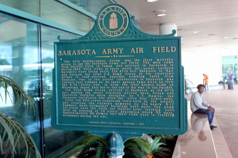
On Airport Circle 0.4 miles east of North Tamiami Trail (U.S. 41), on the right when traveling west.
Sarasota Bradenton International Airport
Citizens from Sarasota and Bradenton began work in 1939 to create a joint airport as two earlier unpaved Sarasota airports became obsolete. With development of the project by the Works progress . . . — — Map (db m146085) HM
On South Washington Boulevard (U.S. 301) at Ringling Boulevard, on the right when traveling north on South Washington Boulevard.
Built by Charles Ringling in 1925 on the site of the number one green of the Old Gillespie Golf Course, this building was originally known as the Ringling Terrace Hotel. It later became known as the Sarasota Terrace Hotel. After passing through . . . — — Map (db m146188) HM
On Ringling Boulevard at Brink Avenue, on the right when traveling east on Ringling Boulevard.
(Front)
Sarasota County was formed in 1921, a year that coincided with the developing Florida Land Boom. Community leaders decided to call attention to the advantages of visiting and living in Sarasota by establishing a county fair and . . . — — Map (db m260670) HM
On Boulevard of the Arts west of North Tamiami Trail (U.S. 41), on the right when traveling west.
(side 1)
The first garden club. known as the Founder's Circle, was organized on May 6, 1927, with Mrs. Mable Ringling as its first president. 1931 marked the circle's first flower show, which was held at the home of Mrs. Ellen Caples. . . . — — Map (db m217059) HM
On South Tamiami Trail (U.S. 41) 0.1 miles north of Bahia Vista Street, on the right when traveling north.
Sarasota High School, in its prior location, had become
accredited in 1915, with its first graduating class of four women.
The Class of 1928 began its senior year here in the new, large
high school building. Since then the school has graduated . . . — — Map (db m306925) HM
On Bayfront Drive (U.S. 41) 0.1 miles north of Main Street, on the right when traveling south.
Sarasota Bay and its downtown bayfront have long been considered the brightest jewels in Sarasota’s crown. In 1910 Bertha Palmer, who helped put Sarasota on the international map, proclaimed Sarasota Bay more beautiful than the Bay of Naples. . . . — — Map (db m97141) HM
On South Bronough Street 0.1 miles south of West Pensacola Avenue, on the right when traveling south.
Sarasota County
The 97th Bomb Group, U.S. Army Air Corps arrived in Sarasota, FL on March 29, 1942 with four squadrons and all service units.
The 97th trained in Sarasota until deployed to England on
May 14, 1942. The 97th . . . — — Map (db m210625) HM WM
On Bayfront Drive at Main Street, on the right when traveling west on Bayfront Drive.
Sarasota War Memorial The Sarasota War Memorial was commissioned by American Legion Bay Post 30 and designed by architect Clare C. Hosmer. On November 11, 1928, it was dedicated at the city’s Five Points intersection in a ceremony observing . . . — — Map (db m148343) WM
On Central Avenue at North Pineapple Avenue, on the left when traveling north on Central Avenue.
On a bright spring morning in 1885, a surveying team from the Florida Mortgage and Investment Company cleared a ten foot area in what is today the center of Five Points. The group was led by Richard Paulson who announced: "We will lay out the . . . — — Map (db m97142) HM
On Fruitville Road (Florida Route 780) at Bearded Oaks Drive, on the right when traveling west on Fruitville Road.
Lynching in America. Racial terror lynchings between 1865 and 1950 claimed the lives of at least 6,500 Black people and terrorized millions more. Racial hierarchy persisted after the Civil War and Emancipation, resulting in . . . — — Map (db m246801) HM
On Main Street east of South Washington Boulevard (U.S. 301), on the right when traveling east.
Side 1
On July 1, 1921, Sarasota County came into existence. Interest in breaking away from Manatee County had led to a series of public meetings the previous summer. Lack of good roads, inadequate representation in Tallahassee, and . . . — — Map (db m146106) HM
On Veterans Boulevard south of State Road 72, on the right when traveling south.
Dedicated to the memory of all the patriotic men and women who answered their country's call to service.
George W. Bush
President of the United States
James B. Peake
Secretary
U.S. Department of Veterans Affairs
William F. Tuerk . . . — — Map (db m241071) WM
On McClellan Parkway at South Osprey Avenue, on the left when traveling north on McClellan Parkway.
Near this spot was Sarasota's First Post Office established in the home and store of Charles E. Abbe, appointed postmaster August 16, 1878 — — Map (db m146390) HM
On State Road 72 (Florida Route 72) 0.1 miles east of Saddle Creek Trail, on the left when traveling east.
Sarasota
VA National Cemetery
Dedicated to the memory of
all the patriotic men and women
who answered their country’s call to service.
George W. Bush
President of the United States
James B. Peake . . . — — Map (db m247712) HM
On Whitfield Avenue just west of Phillips Street, on the left when traveling west.
(side 1)
The southern portion of Whitfield Estates was developed on land originally owned (1876-1912) by Fannie and General John Riggin Jr., an aide-de-camp of General Ulysses S. Grant during the Civil War.
In 1924 a corporation led by . . . — — Map (db m100919) HM
On North Rhodes Avenue at Fruitville Road, on the left when traveling south on North Rhodes Avenue.
(Front)
Franklin Field
When Tony Jannus landed his airboat on Sarasota Bay near the Sarasota Yacht Club on North Gulfstream Avenue in April 1914, the local newspaper expressed hope that his arrival would spawn the . . . — — Map (db m260636) HM
On North Tamiami Trail (U.S. 41) near 11th Street, on the right when traveling south.
This area, so named for its outcroppings of yellow limestone, was the home of Sarasota's first inhabitants-the pre-historic and Calusa Indians. Yellow Bluffs later became the homesite of William H. Whitaker, Sarasota's first known white settler. . . . — — Map (db m41293) HM
On South Pineapple Avenue at Oak Street, on the left when traveling south on South Pineapple Avenue.
Owen Burns (1869-1937)
Owen Burns was one of Sarasota's most distinguished citizens and connected with virtually every early development of the city. He first came to Sarasota on vacation from Chicago in 1910 and decided to make it his . . . — — Map (db m277723) HM
On North Tamiami Trail (U.S. 41) at 10th Street, on the left when traveling north on North Tamiami Trail. Reported permanently removed.
Judah P. Benjamin, later considered "the Brains of the Confederacy," was an American lawyer and statesman. He was born on Saint Croix Island in 1811, grew up in South Carolina, and was educated at Yale College. He practiced law in New Orleans, . . . — — Map (db m65418) HM
On South Pineapple Avenue at Lemon Avenue, on the right when traveling north on South Pineapple Avenue.
L'Aria della Figlia Muta, known as The Mermaid Fountain, was created by Nancy Goodheart Matthews in 1993. In 1995 the Smithsonian Institution chose to register this artwork as a sculpture in their inventory of American artists in public and private . . . — — Map (db m277827) HM
On Central Avenue at 8th Street, on the right when traveling north on Central Avenue.
Rosemary Cemetery is burial place for many early Sarasota citizens, civic leaders, and entrepreneurs including Scotsman John Hamilton Gillespie, first mayor and local manager for Florida Mortgage & Investment Co., British land developers of the . . . — — Map (db m148054) HM
Near McIntosh Road 0.5 miles north of Palmer Ranch Parkway, on the right when traveling north.
The railroad came to Venice in 1911 at the request of Mrs. Potter (Bertha) Palmer. The Seaboard Air Line (SAL) Railway extended its line from Fruitville through Bee Ridge, where the Palmer's Sarasota-Venice Company was developing land, to the . . . — — Map (db m124900) HM
Near Laurel Road East (County Highway 762) 0.5 miles east of Tamiami Trail (Highway 41), on the left when traveling east.
Laurel Turpentine Company
As the turpentine industry spread through southwest Florida, landowners leased turpentine rights to contractors who hired operators for camps that would harvest gum from thousands of acres of pine woods. The Laurel . . . — — Map (db m125006) HM
On Bay Shore Road at Myrtle Street, on the left when traveling north on Bay Shore Road.
(side 1)
5,000 years ago, prehistoric Indians seasonally came to these shore, drawn by freshwater springs, bays teeming with fish and shellfish, and woods rich with game. By 1000 A.D. their middens, ceremonial mounds, and a village plaza . . . — — Map (db m60327) HM
On North Maple Street at Coconut Avenue, on the right when traveling north on North Maple Street.
The Lemon Bay Woman's Club was organized in 1918 by Dr. Mary Green who was a school teacher in Englewood. Originally named the Lemon Bay Mother's Club, a name retained until April 1924, the club played an important role in the development of the . . . — — Map (db m261081) HM
On Central Avenue at 8th Street, on the left when traveling north on Central Avenue.
A Place for Remembrance
Rosemary Cemetery has been established place within the community since 1886, when it was included in Sarasota’s original town plan. The following year, an English settler named Tom Booth marked the first . . . — — Map (db m148068) HM
On North Osprey Avenue at 8th Street, on the right when traveling north on North Osprey Avenue.
(side 1)
John Hamilton Gillespie, the father of Sarasota, arrived here in 1886 at the age of 34. His mission was to rejuvenate the failed Ormiston Colony, a group of 60 Scottish settlers who had come in 1885 expecting to find a "Little . . . — — Map (db m277451) HM
On Central Avenue at 8th Street, on the left when traveling north on Central Avenue.
Individual Variation
As you walk through Rosemary Cemetery, examine each of the markers carefully. They offer clues about the former lives of the deceased and the thoughts of those who buried them.
(sidebar)
Rosemary . . . — — Map (db m148071) HM
On 12th Street 0.1 miles east of North Tamiami Trail (U.S. 41), on the right when traveling east.
In 1882 this "handsome residence" was under construction for Alfred and Mary Bidwell on land Mary purchased from the State of Florida for one dollar an acre. Before construction the Bidwell's apparently occupied the detached kitchen-dining room . . . — — Map (db m97086) HM
On Bee Ridge Road (Florida Route 758) 0.1 miles east of South Tamiami Trail (U.S. 41), on the left when traveling east.
(side 1)
Peter Crocker
Peter Crocker was born in Wheeler, Stuben County, New York, on July 16, 1843. When he was 18 years of age he enlisted as a private in the Volunteer Union Army and served two three-year terms. During the Civil . . . — — Map (db m260761) HM
Near Plaza De Santo Domingo east of Van Wezel Way, on the left when traveling east.
(side 1)
In 1936, the City of Sarasota acquired approximately 40 acres of land for a bayfront civic center. It was located just south of (now) 10th Street and between (now) North Tamiami Trail and the bay. Mayor E. A. Smith announced . . . — — Map (db m217065) HM
On Higel Avenue at Siesta Drive, on the right when traveling north on Higel Avenue.
Siesta
Present Siesta Key appeared on early maps as Clam Island, "Muscle" Island, and Palm Island. Fishery Point lay along the prominent channel of Big Sarasota Pass, called Boca Sarazota in the 1770s, the entrance to Sarasota Bay. The site . . . — — Map (db m170470) HM
On Beach Road (Alternate County Road 789) at Beach Way Drive, on the left when traveling west on Beach Road.
Side 1
This island has had various names. During the 1800s and early 1900s it was known as Little Sarasota Key and Sarasota Key. Common usage of the name Siesta, taken from a residential development at the islands north side, began . . . — — Map (db m146239) HM
Near Benjamin Franklin Dr at Taft Drive, on the left when traveling south.
Side 1
Otto Schmidt Zoldan, a pioneer, settled on the southern tip of this key and in 1904 applied for a homestead. His claim, granted in 1910, included much of the land which became South Lido Park. Once known as Sarasota Key, the . . . — — Map (db m146367) HM
Near Honore Avenue 0.1 miles south of Bee Ridge Road (State Road 758), on the right when traveling south.
The Wilson House is significant as an example of early Sarasota architecture and as the home and medical office of C.B. Wilson.
In 1877, A.M. “Gus” Wilson settled in Miakka, then part of Manatee County. He served the community as . . . — — Map (db m136015) HM
Near Colonia Lane East 0.5 miles east of South Tamiami Trail (U.S. 41), on the left when traveling east.
Turpentine
Early in the 20th Century, turpentine camps were established in Nokomis and Venice. Typically black laborers cut a V-shaped “cat face” in the bark of pine trees, from which gum oozed into a clay or tin pot nailed to the tree. . . . — — Map (db m124982) HM
On 34th Street at Gillespie Avenue, on the right when traveling west on 34th Street.
Side 1
The Robert L. Taylor Community Complex grew out of the "Colored Service Men's Club" building that had served black soldiers during World War II. Newtown resident John Floyd supervised construction of the wood frame structure. . . . — — Map (db m146086) HM
On Adams Lane west of East Avenue, on the right when traveling east.
Side 1
Payne Park was host to many of Major League Baseball's most renowned figures from 1924, when the reigning champion New York Giants of the National League opened spring training, until 1988, when the Chicago White Sox of the American . . . — — Map (db m146026) HM
On John Ringling Boulevard (State Road 789) at Golden Gate Point, on the right when traveling east on John Ringling Boulevard.
Cedar Point/Sunset Park
Cedar Point, a hook of land on Sarasota Bay, was platted in 1899 and recorded as an addition to the Town of Sarasota in 1900. Split into north and south sections by North Gulf Stream Avenue, Cedar Point was home to . . . — — Map (db m97107) HM
On Proctor Road just west of Lords Avenue, on the right when traveling east.
Side 1
Riverview High School originally consisted of modern steel and glass structures set among tall native pines in Sarasota's developing suburbs. When the school opened in 1958, it became known internationally for its innovative architecture, . . . — — Map (db m156534) HM
On Webber Street 0.1 miles west of South Tamiami Trail, on the right when traveling east.
“Never do less than your best.”
Dorothye Smith
First African-American
principal post segregation
Served Southside Elementary School
from 1972 til 1983 — — Map (db m264463) HM
On South Osprey Avenue at Hyde Park Street, on the right when traveling north on South Osprey Avenue.
De Sota Park
During the Florida Land Boom of the 1920's, many new subdivision were platted, both within the City of Sarasota and within expanded city limits. On September 10, 1924, Lewis Combs (1892-1943), a native of Illinois who came to . . . — — Map (db m146044) HM
On South Osprey Aveune at Hibiscus Street, on the right when traveling north on South Osprey Aveune.
De Sota Park
During the Florida Land Boom of the 1920's, many new subdivision were platted, both within the City of Sarasota and within expanded city limits. On September 10, 1924, Lewis Combs (1892-1943), a native of Illinois who came to . . . — — Map (db m146045) HM
On Ringling Boulevard west of South Washington Blvd (U.S. 301), on the right when traveling east.
(side 1)
“The Father of Sarasota,” John Hamilton Gillespie, was born in 1852 in Edinburgh, Scotland. He arrived here in 1886 to assist the failing Florida Mortgage and Investment Company, a development company partially owned . . . — — Map (db m146104) HM
On Gillespie Avenue 0.2 miles south of 12th Street, on the right when traveling south.
The Florida Mortgage and Investment Company deeded five acres in 1905 to Trustees John Mays, Willis G.P. Washington, Lewis Colson, Campbell Mitchell and J.P. Carter for a "colored" cemetery. The land was platted in 1910 as Oaklands Cemetery. For . . . — — Map (db m92862) HM
Near Benjamin Franklin Drive at Grant Drive, on the left when traveling north.
Lido Beach Casino
For nearly thirty years the Lido Beach Casino attracted residents and tourist for pool and gulf swimming, dining, dancing, shopping, and enjoying the beach. Activities such as swim meets, beauty pageants, and school and . . . — — Map (db m146244) HM
On Mound Street (U.S. 41) just east of South Osprey Avenue, on the right when traveling west.
Side 1
Mable Ringling Memorial Fountain
Mable Ringling, born Armilda Burton on March 4, 1875, married John Ringling on 1905 and became a Sarasota winter resident in 1911. Mable, an avid gardener, created the formal Ca'd'Zan rose garden. . . . — — Map (db m121011) HM
Near Circus Boulevard 0.1 miles east of Calliandra Drive. Reported missing.
Bobby Jones' name already was linked to Sarasota when he attended the dedication ceremony February 13, 1927, for Bobby Jones Municipal Course, which had opened the previous June. The course, 2-1/2 miles east of downtown, replaced one just south . . . — — Map (db m218407) HM
On North Tamiami Trail (U.S. 41) at 18th Street, on the right when traveling north on North Tamiami Trail. Reported missing.
Tourism has long been important to Sarasota's history and economy. Winter visitors began coming to the area in the 1880s with some staying in Sarasota's first hotel, The DeSoto Hotel, which was completed in 1887. Tourism increased in the 1920s as . . . — — Map (db m217051) HM
On North Pineapple Ave at 1st Street, on the right when traveling south on North Pineapple Ave.
The Edwards Theatre was the dream of Sarasota County’s native son and early notable mayor, Arthur B. Edwards, who dedicated himself to the proposition that a modern city be built on the shores of Sarasota Bay. He was born October 2, 1874, and . . . — — Map (db m146140) HM
On Imperial Drive 0.2 miles west of North Tamiami Trail (U.S. 41), on the right when traveling west.
Whitaker Family
William Henry Whitaker arrived in Sarasota Bay in the early 1840s. He built a cedar log cabin at “Yellow Bluffs,” part of nearly 200 acres he would acquire along the bay between Hog Creek and today’s Indian Beach . . . — — Map (db m97093) HM
Near Central Sarasota Parkway 0.7 miles east of McIntosh Road, on the right when traveling east.
After her visit to Sarasota in 1910, Mrs. Potter (Bertha) Palmer and family began buying thousands of acres in the region. One large segment extended from their Sarasota-Venice Company's Bee Ridge development south to Laurel. The present 10,000-acre . . . — — Map (db m125021) HM
Near Ringling Boulevard 0.1 miles east of South Links Avenue, on the right when traveling west.
(Side 1)
Charles Ringling, along with his wife Edith and their children, helped Sarasota become a dynamic, thriving West Coast community. Born in 1864, he was actively involved in the operation of the Ringling Brothers and Barnum & Bailey . . . — — Map (db m145879) HM
On North Orange Avenue just south of 35th Street, on the left when traveling north.
Side 1
Emma E. Booker, a pioneer Black educator was teaching in Sarasota's public school for Negro children in the 1910s. By 1918 she was principal of "Sarasota Grammar School" which held classes in rented halls. The Julius Rosenwald Fund helped . . . — — Map (db m121010) HM
On Bahia Vista Street at Brewer Place, on the right when traveling west on Bahia Vista Street.
In December 1913, Oscar and Alice Burton joined real estate developer and future Sarasota mayor Arthur B. Edwards (1914-1915 and 1920-1921) and his wife Fannie in selling the land south of Hudson Bayou to the Sarasota Improvement Company. In . . . — — Map (db m92861) HM
On Mound Street (U.S. 41) 0.1 miles east of South Osprey Avenue, on the right when traveling west.
Don Smally was instrumental to the restoration of Mable Ringling Fountain. The restoration was one of his of his many projects as a respected leader of Sarasota who championed its progress and preserved its heritage. In 1956 Don founded Smally, . . . — — Map (db m148167) HM
Near South Tamiami Trail (U.S. 41) at Constitution Boulevard, on the right when traveling south.
The Edson Keith estate on the south bank of Phillippi Creek, typical of the grand estate houses erected by the extensive Chicago coterie of friends in Sarasota, reflects much of Sarasota's most venerable history. The estate encompasses . . . — — Map (db m151034) HM
On North School Avenue at Main Street, on the right when traveling north on North School Avenue.
(side 1)
A 41-mile Tampa Southern line, "The Fort Ogden Extension," was constructed in 1925-1926 from Sarasota southeasterly to a junction at Southfort on the Lakeland-Naples line of the Atlantic Coast Line. A pair of daily passenger . . . — — Map (db m146103) HM
On North Beneva Road at 12th Street, on the left when traveling north on North Beneva Road. Reported missing.
On January 12, 1929, Sarasota dedicated its first municipal airport located on 160 acres just west of Oriente Avenue, now Beneva Road, and north of Fruitville Rd. Pilots performed aerial maneuvers and stunts for the crowd, many of whom felt an . . . — — Map (db m218405) HM
Near East Venice Avenue near North Seaboard Avenue, on the right.
The first successful railroad into what is now Sarasota County came when the United States and West Indies Railroad and Steamship Company, a subsidiary of the Seaboard Air Line Railway (SAL), brought its first train into Sarasota in 1903. Two . . . — — Map (db m4876) HM
Near Benjamin Franklin Drive at Coolidge Drive, on the right when traveling south.
Side 1
Beaches, a cherished asset to Sarasota County, were not always welcoming to Sarasota’s African–American communities. Prior to Brown vs. the Board of Education and Rosa Parks’ refusal to give up her bus seat to a white . . . — — Map (db m146250) HM
On Siesta Drive (Florida Route 758) at Tangier Terrace, on the left when traveling west on Siesta Drive.
Side 1
Sarasota's population was soaring by the early 1920s, the homes were needed to accommodate those moving into the area. The two parcels of land that would become the nucleus of San Remo Estates were originally purchased by business . . . — — Map (db m146023) HM
On N Lemon Avenue near 1st Street, on the right when traveling north.
On this site in 1903, the U.S. and West Indies Railroad and Steamship Company built a depot. This railroad, subsequently incorporated into the Seaboard Air Line Railway, provided great impetus to the town's turn-of-the-century progress. Trains . . . — — Map (db m41350) HM
Near Northeast 29th Place 0.5 miles south of East Silver Springs Boulevard (State Highway 40).
On June 17, 1955, a fire "of undetermined origin" raced through several of the attractive, 1949 Spanish-style buildings, including the gift shop, café, and offices. Victor A. Lundy, an architect from Sarasota, was selected to design the new . . . — — Map (db m132198) HM
On West Tamiami Circle north of Tennessee Lane, on the right when traveling south.
Side 1
Bay Haven School is one of two elementary schools built in Sarasota from identical plans to accommodate population growth resulting from the 1920s real estate boom. Bay Haven and Southside Elementary were designed by architect M. Leo . . . — — Map (db m146087) HM
On Monica Parkway just east of North Lockwood Ridge Road, in the median.
Side 1
After World War II, Sarasota experienced an influx of new residents, creating a housing boom. Martin Paver, retired from his business in New York, was on a pleasure cruise in 1949 when he and his wife Mildred docked in Sarasota to buy . . . — — Map (db m170464) HM
On St Armands Circle at South Boulevard of the Presidents when traveling south on St Armands Circle.
The incomparable Black American saddle bred mare, Starless Night, owned and trained by Capt. William Heyer, appeared in numerous circuses and other venues throughout her stellar career, including the Ed Sullivan Show. Always in demand and . . . — — Map (db m147144) HM
On St Armands Circle at John Ringling Boulevard, on the left when traveling north on St Armands Circle.
High energy bicycling French family, they were the first European act brought to the U.S. by Ringling Bros. and Barnum & Bailey after World War II. The fast pace of their act, their acrobatic tricks, flashy costumes and comedy antics of Mauris . . . — — Map (db m147362) HM
On Tamiami Trail South (Scenic U.S. 41), on the right when traveling south.
Among the number of circuses that have called Sarasota County home, the Ringling Bros. and Barnum & Bailey Circus (RBBB) is the largest and the one that has had the longest association with Venice. Its roots go back to a small show the five . . . — — Map (db m211950) HM
On Benjamin Franklin Drive at McKinley Drive, on the right when traveling south on Benjamin Franklin Drive.
Side 1
Built by 1950, the Gulf Beach Motel was part of the post World War II motel construction boom that addressed the needs of a growing number of tourists to the area. With the end of war-time gas rationing and the resumption o auto . . . — — Map (db m146331) HM
On Manasota Key Road at Manasota Beach Road, on the right when traveling south on Manasota Key Road.
After the Civil War, many Georgians moved their families to Southern Florida. Joseph Daniel "Jody" Anderson, born in Georgia in 1867, was a child when his father moved to the Tampa/Sara Sota area. In 1884, Joseph became the head of the Anderson . . . — — Map (db m156335) HM
On 33rd Street east of Goodrich Avenue, on the right when traveling west.
Understanding the importance of early education for the young children of their community, several African-American women organized and founded the Newtown Day Nursery. This grassroots organization, established around 1930, included . . . — — Map (db m146223) HM
On St Armands Circle at John Ringling Boulevard, on the left when traveling north on St Armands Circle.
A Ringling Bros. superstar of the 1920s, he was undisputed “King of the Flying Trapeze.” At a time when few had attempted it and even fewer had succeeded, he made the difficult triple back somersault a highlight of every performance, . . . — — Map (db m147667) HM
On South Osprey Avenue at Cherokee Drive, on the right when traveling south on South Osprey Avenue.
(side 1)
Cherokee Park
It Started with a Wall
The founder of Cherokee Park, James C. Brown, commissioned master builder Leadley Ogden to erect the walls, gateposts and corner markers. They were constructed in the . . . — — Map (db m260936) HM
On North Gulfstream Avenue at Main Street, on the right when traveling south on North Gulfstream Avenue.
On December 23, 1885 a number of Scottish families came ashore on or near this spot to settle land they had purchased for their homes in a new country. They met wilderness and hardship instead of the established town promised them; causing many to . . . — — Map (db m97100) HM
On Longmeadow at Glebe Farm Road, on the left when traveling north on Longmeadow.
In 1973, Sir Frank Taylor of Taylor Woodrow
Construction purchased the Newburn Ranch in
unincorporated Sarasota County. On November 14,
1974, Sarasota County approved the development
plan for The Meadows. The Meadows was one of the
first . . . — — Map (db m305962) HM
On St Armands Circle at North Boulevard of the Presidents when traveling west on St Armands Circle.
Clyde Beatty, master trainer of wild animals presented the largest group of jungle beasts ever seen in the circus – 40 lions and tigers in one cage. His spectacular showmanship won him center ring stardom with Ringling and other major . . . — — Map (db m147052) HM
On St Armands Circle near South Boulevard of the Presidents, on the left when traveling east.
Franz Unus, an equilibrist of unequaled skill. Originated and perfected the spectacular one-finger stand in which he balanced his body on his right index finger atop a large electric light bulb. He was a center ring star with Ringling for 13 . . . — — Map (db m147217) HM
On Main Street at North Palm Avenue, on the right when traveling south on Main Street.
Historic
Palm Tower
From livery stable, fish house and pool hall in the 1800’s to
Sarasota’s First “Skyscraper”
Construction began in 1924, was completed in 1925, expanding upwards from a 2-story boarding . . . — — Map (db m148205) HM
On St Armands Circle at John Ringling Boulevard, on the left when traveling north on St Armands Circle.
With the guiding hand of Pablo Rodriguez, he and his family formed what became one of the most accomplished family aerial acts of the 1960s, 1970s and 1980s. Their aerial bar act and double and triple-wide flying trapeze-wide acts were among the . . . — — Map (db m147375) HM
On South Indiana Avenue at 2nd Avenue, on the left when traveling north on South Indiana Avenue.
Green Street Church and Museum
The Green Street Church Museum began as Englewood's first church building, which was initially on Magnolia near Green Street. Community Methodists began holding Sunday School classes in Josie Quimby . . . — — Map (db m268483) HM
On Proctor Road at McIntosh Road, on the right when traveling east on Proctor Road.
From 1877 to 1891, Isaac Alderman Redd was pastor of the Friendship Baptist Church chartered by ten area families. The growing Bee Ridge community included Redd's oldest daughter Laura FeDonia, who with her first husband S.C. Rawls first settled . . . — — Map (db m290631) HM
On Boulevard of the Arts at Central Avenue, on the right when traveling east on Boulevard of the Arts.
(side 1)
This Black community grew as businessmen, fishermen, physicians, nurses, teachers, farmers, contractors, carpenters, laborers, drivers, masons, blacksmiths, laundry workers and railroad workers made this area their home. Along . . . — — Map (db m146209) HM
On Honore Avenue just south of Sawgrass Road, on the right when traveling north.
(Side 1)
Fruitville Elementary School, the largest elementary school in Sarasota County in 1989, began as a converted corn crib in the late 1880's. Charles L. Reaves, a pioneer of the Fruitville area with his wife Martha Tatum of Tatum . . . — — Map (db m150432) HM
On St Armands Circle at John Ringling Boulevard, on the left when traveling south on St Armands Circle.
Hungary’s Richter Family and Germany’s Casselly Family represent two multi-generational circus dynasties dating from 1821. Both families embrace the concept of humans and animals or king side by side in the circus arts, for which they have won . . . — — Map (db m244492) HM
On Nippino Trail East east of North Tamiami Trail (U.S. 41), on the right when traveling east.
One of the area's oldest educational institutions, the Nokomis School, was built in 1924 on Nippino Trail. The photo shows the two-room Mediterranean Revival style school.
Originally, children in grades one through eight attended the . . . — — Map (db m38372) HM
On North Tamiami Trail (U.S. 41) at Spanish Point Road, on the left when traveling north on North Tamiami Trail.
This 30-acre preserve includes prehistoric shell middens and a burial mound dating from 3,000 B.C. to 1,000 A.D., buildings from the homestead of John Greene Webb, and gardens from the winter estate of Mrs. Potter Palmer. In 1975, it became the . . . — — Map (db m60326) HM
On Andrew Avenue 0.2 miles south of Clark Road (County Road 72), on the right when traveling north.
Side 1
The Bee Ridge Woman's Club has been an integral part of the growth and development of the Bee Ridge community, providing social outlet, community pride, and staunch support for many public interest projects since the early 1900s. Organized . . . — — Map (db m136014) HM
On Fruitville Road (State Road 780) at Adelia Avenue, on the right when traveling east on Fruitville Road.
Beginning in 1889, circuit-riding Jesuit priests served the pastoral needs of Sarasota's small, but devoted Catholic community. In 1912, after years of meeting in various homes, the congregation built a small wooden mission church at Adelia and . . . — — Map (db m97105) HM
On 12th Street 0.1 miles east of North Tamiami Trail (U.S. 41), on the right when traveling east.
Whitaker Cemetery
1232 12th Street
The Oldest Cemetery
In Sarasota
First Internment 1879
Maintained By The
Sara De Soto Chapter, NSDAR
Historically Designated
January 20, 2004
By The City Of Sarasota, . . . — — Map (db m148169) HM
On Main Street at South Palm Avenue, on the right when traveling north on Main Street.
American National Bank
Built 1926
Francis Palmer Smith - Architect
Adair & Sentor – Builder
Has been placed in the
National Register of Historic Places
&
Designated A Historic Structure By
The City Of Sarasota, . . . — — Map (db m148224) HM
On South Tamiami Trail (U.S. 41) just north of Fiesta Drive, on the right when traveling north.
Jackson and Katherine Bispham started a dairy in 1922 north of Sarasota with Sarasota County Dairy Permit No. 2. Later that year Bispham moved his operation to the area of present South Tamiami Trail and Fiesta Street, named it Bayside Dairy, and . . . — — Map (db m101064) HM
On St Armands Circle at John Ringling Boulevard, on the left when traveling north on St Armands Circle.
A spectacular aerial performer, he cofounded Circus Sarasota and became the driving force behind its emergence as one of the country’s elite circuses. By presenting top quality performances and conducting a highly regarded community outreach . . . — — Map (db m147501) HM
On McIntosh Road at Proctor Road, on the right when traveling south on McIntosh Road.
Side 1
In 1915, Bee Ridge, then part of Manatee County, supported a train station, post office, hotel, general store, and school. A second wave of settlers who moved into Bee Ridge desired a church in their community. In January, 1917, the . . . — — Map (db m135978) HM
On Arlington Street at South Orange Avenue, on the left when traveling east on Arlington Street.
The Wallenda circus troupe originated in Germany, where its members developed a daring highwire act. Early in their careers they achieved some fame touring with different circuses in Europe, but Karl Wallenda became convinced that circus . . . — — Map (db m92848) HM
On Main Street at South Lemon Avenue, on the right when traveling east on Main Street.
Worth’s Block
Built 1913
H.B. Westbrook
Builder
Has been placed in the
National Register Of Historic Places
&
Designated A Historic Structure By
The City Of Sarasota, Florida — — Map (db m148218) HM
Near Winson Avenue 0.2 miles south of West Fray Street, on the right when traveling south.
You are walking on 2,400 years of garbage. This archaeological midden is the açcumulation of trash from the people who lived here through the centuries. The midden contains pottery, stone tools, shell tools, and personal items like beads. Although . . . — — Map (db m264690) HM
On Bay Shore Road 0.1 miles south of 58th Street, on the right when traveling south.
This Venetian Gothic palace on Sarasota Bay, palatial home of John and Mable Ringling was completed in the mid-20s.
The mansion and the John and Mable Ringling Museum of Art, surrounded by lovely gardens and embellished with Italian statuary . . . — — Map (db m146125) HM
307 entries matched your criteria. The first 100 are listed above. Next 100 ⊳
Thin black lines indicate changes in relevance. Between each pair of lines entries are ordered geographically but all have the same relevance.
* Inflectional forms of words are their plurals, singulars, and possessives as well as gramatical tenses and similar variations.