689 entries match your criteria. Entries 101 through 200 are listed.⊲ Previous 100 — Next 100 ⊳
Historical Markers and War Memorials in
By Jay Noble, August 28, 2026
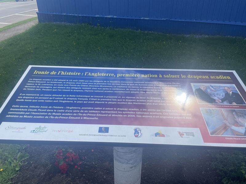
Irony of History: England, First Nation to Salute the Acadian Flag Marker
101 ► Prince Edward Island, Summerside — Irony of History: England, First Nation to Salute the Acadian Flag — Ironie de l'histoire : l'Angleterre, première nation à saluer le drapeau acadien —  |
| On Heather Moyse Drive, on the right when traveling east. | |||
| 102 ► Prince Edward Island, Summerside — R.C.A.F. Station/C. F. B. Summerside 1941-1992 — |
| On Summer Street, on the right when traveling north. | |||
| 103 ► Prince Edward Island, Summerside — R.T. Holman Ltd. — |
| On Water Street, on the right when traveling west. | |||
| 104 ► Prince Edward Island, Summerside — Summerside Steamers / Les bateaux à vapeur de Summerside — |
| On Water Street, on the right when traveling west. | |||
| 105 ► Prince Edward Island, Summerside — The College of Piping & Celtic Performing Arts of Canada — |
| On Water Street, on the left when traveling east. | |||
| 106 ► Prince Edward Island, Summerside — The Drill Shed — |
| On Spring Street north of Church Street, on the right when traveling south. | |||
| 107 ► Prince Edward Island, Summerside — The Great Fire of 1906 — |
| On Foundry Street east of Summer Street, on the left when traveling east. | |||
| 108 ► Prince Edward Island, Summerside — The Great Trail — |
| On Water Street, on the right when traveling west. | |||
| 109 ► Prince Edward Island, Summerside — The Holman Homestead — |
| On Fitzroy Street east of Central Sleep, on the left when traveling west. | |||
| 110 ► Prince Edward Island, Summerside — The Indian Head Lighthouse & Breakwater — |
| On Water Street, on the left when traveling north. | |||
| 111 ► Prince Edward Island, Summerside — The Striped Skunk / La Moufette Rayée — Mephitis mephitis — |
| On Water Street, on the right when traveling west. | |||
| 112 ► Prince Edward Island, Summerside — The Summerside Fire of 1906 / L’Incendie de Summerside en 1906 — |
| On Water Street, on the right when traveling west. | |||
| 113 ► Prince Edward Island, Summerside — Trans Canada Trail Logo — |
| On Harbour Drive, on the right when traveling east. | |||
| 114 ► Prince Edward Island, Summerside — Wastewater Treatment Centre / Centre de traitement des eaux usées |
| On Mackenzie Drive, on the left when traveling west. Reported damaged. | |||
| 115 ► Prince Edward Island, Tignish — Yankee Gale — |
| On Prince Edward Island Route 12 1.6 kilometers south of William Travers Lane, on the right when traveling north. | |||
| 116 ► Prince Edward Island, Tignish Shore — Myrick Shore — |
| On Harbour Road at Tignish Shore Road, on the right when traveling north on Harbour Road. | |||
| 117 ► Prince Edward Island, Tignish Shore — Tignish — |
| On Harbour Road, on the right when traveling north. | |||
| 118 ► Prince Edward Island, Tryon — 200 Years of Worship and Service — 1792-1992 — |
| On Prince Edward Island 10, on the right when traveling north. | |||
| 119 ► Prince Edward Island, Tryon — Tryon Great War and WWII Memorial — |
| On Prince Edward Island 10 at Samuel Holland Lane, on the right when traveling north on Prince Edward Island 10. | |||
| 120 ► Prince Edward Island, Vernon Bridge — Sir Andrew Macphail (1864-1938) — |
| Near MacPhail Park Road, on the right when traveling west. | |||
| 121 ► Prince Edward Island, Vernon Bridge — The Doorstep Stone — |
| Near MacPhail Park Road, on the right when traveling west. | |||
| 122 ► Prince Edward Island, Vernon Bridge — The Sir Andrew Macphail Homestead / La propriété familiale de Sir Andrew MacPhail — |
| On MacPhail Park Road. | |||
| 123 ► Prince Edward Island, Vernon Bridge — The Story of the Pillars — From McGill University to the Macphail Homestead — |
| On MacPhail Park Road, on the right when traveling west. | |||
| 124 ► Prince Edward Island, Victoria — Hotbed of Culture and Art / Un Foyer de Culture et d'art — |
| On Prince Edward Island 116. | |||
| 125 ► Prince Edward Island, Victoria — Victoria By-The-Sea — |
| On Water Street, on the right when traveling east. | |||
| 126 ► China, Beijing, Hǎidiàn Qū — Hall of Dispelling Clouds — (Paiyun Dian) - 排 云 殿 — |
| Near Yudai Road. | |||
| 127 ► China, Beijing, Hǎidiàn Qū — Nuclei as Heavy as Bulls — Through Collision Generate New States of Matter — |
| On Chengfu Road. | |||
| 128 ► China, Beijing, Hǎidiàn Qū — Purple Heaven Hall — 紫 霄 殿 (Zixiao Dian) — |
| Near Yudai Road. | |||
| 129 ► China, Jiang Su Sheng, Wu Xi Shi — Legend of Longguang Tower — |
| Near Qinyuan Street. | |||
| 130 ► China, Jiang Su Sheng, Wu Xi Shi — Scenic Area of Huishan Ancient Town — |
| Near Xiuzhang Street. | |||
| 131 ► Costa Rica, Alajuela, La Fortuna — Amelia Alfara Rojas — |
| On Route 142 just west of Calle 468, on the right when traveling west. | |||
| 132 ► Costa Rica, Alajuela, San Rafael de Guatuso — Founding of the Community of San Rafael — Monseñor Thiel — |
| On Calle Central at Avenida Central (Route 733), on the right when traveling north on Calle Central. | |||
| 133 ► Croatia, Zagreb, Zagreb — Bogoslav Šulek — |
| On Ulica Nikole Tesle at Preradoviæeva Ulica, on the right when traveling east on Ulica Nikole Tesle. | |||
| 134 ► Croatia, Zagreb, Zagreb — Nikola Tesla — |
| On Trg Svetog Marka, on the left when traveling north. | |||
| 135 ► Croatia, Zagreb, Zagreb — Old City Hall — |
| On Trg Sv. Marka (St. Marks Square), on the left when traveling north. | |||
| 136 ► Denmark, Sjælland, Roskilde — Maglekilde — |
| On Maglekildevej close to Weysegangen when traveling north. | |||
| 137 ► Dominica, Saint David Parish, Salybia — Death of Sadwill Bruney — |
| On Windward Coastal Highway close to Aywasi Kalinago Retreat Road, on the left when traveling west. | |||
| 138 ► Dominica, Saint David Parish, Sineku — Carib History — |
| On Windward Coastal Highway at Sineku School Road, on the right when traveling north on Windward Coastal Highway. | |||
| 139 ► Dominica, Saint George Parish, Roseau — Anglican Church — Explore Roseau — |
| On Victoria Street at Turkey Lane, on the right when traveling west on Victoria Street. | |||
| 140 ► Dominica, Saint George Parish, Roseau — Carnegie Library of Roseau — |
| On Victoria Street, on the right when traveling east. | |||
| 141 ► Dominica, Saint George Parish, Roseau — David the Goliath — |
| On Independence Street just east of Bath Street, on the right when traveling north. | |||
| 142 ► Dominica, Saint George Parish, Roseau — Glory to the French from Dominica — |
| On Dame Mary Eugenia Charles Boulevard. | |||
| 143 ► Dominica, Saint George Parish, Roseau — Methodist Church — Explore Roseau — |
| On Virgin Lane at Cross Street, on the right when traveling north on Virgin Lane. | |||
| 144 ► Dominica, Saint George Parish, Roseau — Morne Bruce Garrison — The Defence of Roseau — |
| On Morne Bruce Road, on the left when traveling north. | |||
| 145 ► Dominica, Saint George Parish, Roseau — Morne Bruce Garrison — North Point Battery — |
| Near Unnamed road just west of Morne Bruce Road, on the right when traveling north. | |||
| 146 ► Dominica, Saint George Parish, Roseau — Neg Mawon Emancipation Monument — |
| On Turkey Lane close to Victoria Street. | |||
| 147 ► Dominica, Saint George Parish, Roseau — Old Market Square — |
| Near Church Street just north of Victoria Street, on the left when traveling north. | |||
| 148 ► Dominica, Saint George Parish, Roseau — Old Prison — Explore Roseau — |
| On Old Street at John's Lane, on the left when traveling south on Old Street. | |||
| 149 ► Dominica, Saint George Parish, Roseau — Roseau Bayfront — Roseau Cruise Ship Berth — Explore Roseau — |
| On Dame Mary Eugenia Charles Boulevard just west of Church Street, on the left when traveling west. | |||
| 150 ► Dominica, Saint George Parish, Roseau — Roseau Bayfront — Ferry Terminal — Explore Roseau — |
| On Dame Mary Eugenia Charles Boulevard at Drury Lane, on the left when traveling west on Dame Mary Eugenia Charles Boulevard. | |||
| 151 ► Dominica, Saint George Parish, Roseau — Roseau Cathedral — Explore Roseau — |
| On Virgin Lane just north of Cross Street, on the right when traveling north. | |||
| 152 ► Dominica, Saint George Parish, Roseau — Woodbridge Bay — Explore Roseau — |
| On Edward Oliver Leblanc Highway just north of Charles Avenue, on the left when traveling north. | |||
| 153 ► Dominica, Saint George Parish, Roseau — World Wars Memorial — |
| On Dame Mary Eugenia Charles Boulevard. | |||
| 154 ► Dominica, Saint George Parish, Roseau, Goodwill — Cecil E. A. Rawle — |
| On Federation Drive close to Charles Avenue. | |||
| 155 ► Dominica, Saint George Parish, Roseau, Goodwill — Simon Bolivar — |
| On Princess Lane at Charles Avenue, on the left when traveling north on Princess Lane. | |||
| 156 ► Dominica, Saint George Parish, Roseau, Pottersville — Pottersville — Explore Roseau — |
| On Elliot Avenue at St. John's Avenue, on the left when traveling north on Elliot Avenue. | |||
| 157 ► Dominica, Saint George Parish, Roseau, Pottersville — Pottersville — By the Pottersville Savannah — Explore Roseau — |
| On Goodwill Road just north of Winston Lane, on the left when traveling north. | |||
| 158 ► Dominica, Saint John Parish, Portsmouth, Chance — Cabrits Calendar of Events — Calendrier des Evènements des Cabrits — |
| Near Bay Street. | |||
| 159 ► Dominica, Saint John Parish, Portsmouth, Chance — Cabrits National Park — |
| Near Bay Street. | |||
| 160 ► Dominica, Saint John Parish, Portsmouth, Chance — Fort Shirley — |
| Near Bay Street. | |||
| 161 ► Dominica, Saint John Parish, Portsmouth, Chance — Guard House, Powder Magazine — |
| Near Bay Street. | |||
| 162 ► Dominica, Saint John Parish, Portsmouth, Chance — Officers' Quarters — |
| Near Bay Street. | |||
| 163 ► Dominica, Saint John Parish, Portsmouth, Chance — Prince Rupert's Garrison — |
| Near Bay Street. | |||
| 164 ► Dominica, Saint John Parish, Portsmouth, Chance — The Trees Return — |
| Near Bay Street. | |||
| 165 ► Dominica, Saint John Parish, Portsmouth, Chance — Upper Battery, Signal Station — |
| Near Bay Street. | |||
| 166 ► Dominica, Saint John Parish, Portsmouth, Chance — Water Catchment, Troops' Kitchen, Stables — |
| Near Bay Street. | |||
| 167 ► Dominica, Saint Joseph Parish, Baroui, Salisbury — The Salisbury Declaration — |
| On an unnamed street, on the left when traveling north. | |||
| 168 ► Dominica, Saint Paul Parish, Canefield — Sugar and Canefield Estate — |
| On 3rd Street at Edward Oliver Leblanc Highway, on the right when traveling north on 3rd Street. | |||
| 169 ► Dominica, Saint Paul Parish, Mahaut — Edward Oliver Le Blanc — |
| On West Coast Road, on the left when traveling south. | |||
| 170 ► Dominican Republic, Porta Plata Province, Porta Plata — Bienvenidos al Museo Fortaleza San Felipe / Welcome to the San Felipe Fortress Museum! — |
| Near Desvio a la Puntilla 0.4 kilometers north of Francisco Alberto Caamano Avenue, on the left when traveling north. | |||
| 171 ► Dominican Republic, Porta Plata Province, Porta Plata — Birgenair Flight 301 Monument — |
| Near Desvio a la Puntilla 0.5 kilometers north of Francisco Alberto Caamano Avenue, on the left when traveling north. | |||
| 172 ► Dominican Republic, Porta Plata Province, Porta Plata — General Gregorio Luperon — |
| Near Desvio a la Puntilla 0.5 kilometers north of Francisco Alberto Caamano Avenue, on the right when traveling north. | |||
| 173 ► Dominican Republic, Puerta Plata Province, Puerto Plata — Robert Hermann Schomburgk — (1804-1865) — |
| Near Antigua Via Ferrea south of Calle Duarte, on the left when traveling north. | |||
| 174 ► Dutch Caribbean, Aruba, Noord, Palm Beach — G.F. "Betico" Croes — 1938-1986 — |
| Near J.E. Irausquin Boulevard. | |||
| 175 ► Dutch Caribbean, Aruba, Noord, Palm Beach — J.E. "Juancho" Irausquin — 1904-1962 — |
| Near J.E. Irausquin Boulevard. | |||
| 176 ► Dutch Caribbean, Aruba, Noord, Palm Beach — J.H.A. "Shon Henny" Eman — 1887-1957 — |
| Near J.E. Irausquin Boulevard. | |||
| 177 ► Dutch Caribbean, Aruba, Oranjestad, Oranjestad-West — 1822 Protestant Congregation Foundation — |
| On Wilhelminastraat. | |||
| 178 ► Dutch Caribbean, Aruba, Oranjestad, Oranjestad-West — Willems III Tower — Monumento Proteha — Oranjestraat/Zouthmanstraat — |
| On Zoutmanstraat. | |||
| 179 ► Dutch Caribbean, Aruba, Santa Cruz, Oranjestad-West — Statue Princess Wilhelmina — |
| On L.G. Smith Boulevard. | |||
| 180 ► Dutch Caribbean, Curaçao, Jan Kok — Rif St.Marie — International protected area under the Ramsar Convention - (February 5th, 2013) — Unique Nature Areas of Curacao — |
| On Weg naar St Willibrordus, on the right when traveling east. | |||
| 181 ► Dutch Caribbean, Curaçao, Lagun — Libertat Galite — |
| Near Weg Zonder Naam, on the left when traveling south. | |||
| 182 ► Dutch Caribbean, Curaçao, Lagun — Start of the Revolt against Slavery — |
| On Weg Zonder Naam, on the right when traveling west. | |||
| 183 ► Dutch Caribbean, Curaçao, Lagun — Tula Monument — |
| On Weg Zonder Naam, on the left when traveling west. | |||
| 184 ► Dutch Caribbean, Curaçao, Sint Willibrordus — 1st Battle won by Freedom Fighters — |
| On Weg naar St Willibrordus, on the right when traveling east. | |||
| 185 ► Dutch Caribbean, Curaçao, Sint Willibrordus — Area Information: Rif St Marie — History — |
| Near Weg Zonder Naam. | |||
| 186 ► Dutch Caribbean, Curaçao, Sint Willibrordus — Headquarters & Meeting with Father Schinck — |
| Near Weg naar Daaibooi. | |||
| 187 ► Dutch Caribbean, Curaçao, Willemstad, Fleur de Marie — Queen Juliana Bridge Memorial — |
| On Presidente Rómulo Betancourt Boulevard, on the right when traveling west. | |||
| 188 ► Dutch Caribbean, Curaçao, Willemstad, Otrobanda — de Rouvilleweg 39 — |
| On De Rouvilleweg, on the left when traveling east. | |||
| 189 ► Dutch Caribbean, Curaçao, Willemstad, Otrobanda — de Rouvilleweg 7 — Kura Agostini — |
| On De Rouvilleweg, on the left when traveling east. | |||
| 190 ► Dutch Caribbean, Curaçao, Willemstad, Otrobanda — de Rouvilleweg 9 — Kura Agostini — |
| On De Rouvilleweg, on the left when traveling east. | |||
| 191 ► Dutch Caribbean, Curaçao, Willemstad, Otrobanda — Dr. Efrain Jonckheer — 1917 - 1987 — |
| On Gouverneur van Slobbeweg, on the right when traveling north. | |||
| 192 ► Dutch Caribbean, Curaçao, Willemstad, Otrobanda — Feliz Chacuto Labor Memorial — |
| On Klipstraat, on the right when traveling south. | |||
| 193 ► Dutch Caribbean, Curaçao, Willemstad, Otrobanda — Fred Arends - The Traditional Dutch Master — Art Gallery Absolute — |
| On Klipstraat, on the right when traveling west. | |||
| 194 ► Dutch Caribbean, Curaçao, Willemstad, Otrobanda — Free at Last — |
| On John F. Kennedy Boulevard, on the right when traveling east. | |||
| 195 ► Dutch Caribbean, Curaçao, Willemstad, Otrobanda — Freedom Monument — |
| On John F. Kennedy Boulevard, in the median. | |||
| 196 ► Dutch Caribbean, Curaçao, Willemstad, Otrobanda — Hulanda Village — Bon Bini to our beautiful village — |
| On Klipstraat, on the right when traveling west. | |||
| 197 ► Dutch Caribbean, Curaçao, Willemstad, Otrobanda — Hulanda Village — Bon Bini to our beautiful village — |
| On De Rouvilleweg, on the left when traveling east. | |||
| 198 ► Dutch Caribbean, Curaçao, Willemstad, Otrobanda — 3/7 — Language — Historical Walking Tour — |
| Near Baden Powellweg. | |||
| 199 ► Dutch Caribbean, Curaçao, Willemstad, Otrobanda — Leonard Burlington Smith — |
| On De Rouvilleweg, on the right when traveling east. | |||
| 200 ► Dutch Caribbean, Curaçao, Willemstad, Otrobanda — Luis Brion Monument — |
| On De Rouvilleweg, on the right when traveling south. | |||
689 entries matched your criteria. Entries 101 through 200 are listed above. ⊲ Previous 100 — Next 100 ⊳