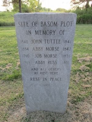
By Anton Schwarzmueller, July 24, 2015
The only other burial marker here
| On Alleghany Road (New York State Route 77) 0.1 miles south of Judge Road ( Route 63), on the right when traveling south. |
| On Lewiston Road (County Route 12) 1 mile east of Allegheny Road ( Route 63), on the left when traveling east. |
| On Lewiston Road (New York State Route 77) 2.7 miles north of Allegany Road ( Route 63), on the left when traveling north. |
| Near Lewiston Road (New York State Route 77) 0.5 miles east of Salt Road. |
| On Alleghany Road (New York State Route 77) at McAlpine Road, on the right when traveling north on Alleghany Road. |
| On Knowlesville Road (County Route 23) 0.8 miles south of Podunk Road, on the right when traveling south. |
| On Judge Road (New York State Route 63) east of Knowlesville Road, on the left when traveling west. |
| On Alleghany Road (New York State Route 63) south of Lewiston Road ( Route 77), on the right when traveling south. |
| Near Lewiston Road (New York State Route 77) 0.5 miles south of Salt Works Road (County Route 43), on the right when traveling west. |
| On Buffalo Street at Church Street, on the right when traveling west on Buffalo Street. |
| On Church Street, on the right when traveling west. |
| On Buffalo Street, on the left when traveling west. |
| On West Main Street (New York State Route 5/63/33) 0.2 miles east of Oak Street ( Route 98), on the right when traveling east. |
| On Harvester Avenue 0.1 miles south of Main Street ( Route 33/5), on the left when traveling south. |
| On West Main Street (New York State Route 5) at Thomas Avenue, on the left when traveling west on West Main Street. |
| On West Main Street (New York State Route 5) west of Ellicott Street ( Route 63), on the right when traveling east. |
| On West Main Street (New York State Route 5) west of Ellicott Street ( Route 63), on the right. |
| Near Harvester Avenue 0.2 miles south of East Main Street ( Route 5). |
| On Upton Road 0.2 miles south of Lear Road, on the left when traveling south. |
| On West Main Street when traveling west. |
| On East Main Street (New York State Route 5) at Ward Street, on the right when traveling west on East Main Street. |
| On Richmond Avenue, on the right when traveling east. |
| On Cedar Street 0.5 miles south of Florence Avenue. |
| On South Lyon Street 0.2 miles south of West Main Street ( Route 5), on the right when traveling south. |
| On West Main Street at Thomas Avenue, on the left when traveling west on West Main Street. |
| On Main Street west of Evans Street ( Route 33), on the left when traveling west. |
| On Main Street near Ellicott Street, on the left when traveling west. |
| On Harvester Avenue, on the left when traveling south. |
| Near Harvester Avenue 0.2 miles south of East Main Street ( Route 5). |
| On West Main Street (New York State Route 5) 0.2 miles east of Oak Street ( Route 98), on the right when traveling east. |
| On Harvester Avenue 0.2 miles south of East Main Street ( Route 5), on the left when traveling south. |
| On East Main Street (New York State Route 5/33) near Bank Street, on the right when traveling west. |
| On West Main Street (New York State Route 5) west of Ellicott Street ( Route 63), on the right when traveling east. |
| On East Main Street (New York State Route 5) at Ellicott Street ( Route 63), on the left when traveling east on East Main Street. |
| On West Main Street Road (New York State Route 5 at milepost 12.1), on the right when traveling east. |
| On Harvester Avenue 0.2 miles south of Main Street ( Route 5). |
| On Harvester Avenue 0.1 miles north of Ellicott Street ( Route 63), on the left when traveling south. |
| On West Main Street (New York State Route 5) near Thomas Avenue, on the left when traveling west. |
| On West Sweden Road 0.2 miles Swamp Road (County Route 6), on the right when traveling north. |
| On Lake Avenue (New York State Route 19) at Townline Road, on the left when traveling south on Lake Avenue. |
| On Lake Street (New York State Route 19) at LeRoy Street, on the right when traveling north on Lake Street. |
| On Clinton St at McKenzie St, on the left when traveling south on Clinton St. |
| On South Lake Avenue (New York State Route 19) just south of Rochester Street, on the right when traveling north. |
| On North Lake Avenue (New York State Route 19) at Leroy Street, on the left when traveling north on North Lake Avenue. |
| On Buffalo Road (New York State Route 33) at Rochester Street, on the left when traveling north on Buffalo Road. |
| On Bethany Center Road (County Route 15) 0.3 miles north of Broadway Street (U.S. 20), on the left when traveling north. |
| On Raymond Road (County Route 49) at Memory Lane, on the right when traveling east on Raymond Road. |
| On Memory Lane 1.2 miles east of Bethany Center Road, on the right when traveling east. |
| On Memory Lane 0.1 miles south of Raymond Road (County Route 49), on the right when traveling south. |
| On Memory Lane 0.5 miles south of Raymond Road (County Route 49), on the right when traveling south. |
| On Bethany Center Road 0.1 miles south of Raymond Road (County Route 49), on the right when traveling north. |
| On Bethany Center Road (County Route 15) at Raymond Road (County Route 49), on the left when traveling south on Bethany Center Road. |
| On Byron Holley Rd (New York State Route 237), on the right when traveling south. |
| On Townline Road (New York State Route 262) 0.1 miles west of Swamp Road, on the left when traveling east. |
| On Holley Byron Road (New York State Route 237) north of New Guinea Road, on the right when traveling north. |
| On Alleghany Road (New York State Route 77) near East Main Street ( Route 33), on the left when traveling south. |
| On Alleghany Road (New York State Route 77) near Sumner Road (Route 21). |
| Near Governor Thomas E. Dewey Thruway (Interstate 90 at milepost 397), 4.3 miles east of Alleghany Road ( Route 77), on the right when traveling east. |
| On Alleghany Road (New York State Route 77) north of West Main Street ( Route 33), on the left when traveling north. |
| Near Alleghany Road (New York State Route 77) near Sumner Road ( Route 21), on the right when traveling north. |
| On Broadway (U.S. 20) 0.3 miles east of Colby Road, on the left when traveling east. |
| On West Muck Road at Quaker Hill Road ( Route 98), on the right when traveling south on West Muck Road. |
| On South Main Street (New York State Route 98) 0.1 miles south of Chapel Street, on the right when traveling north. |
| On Chapel Street at South Main Street ( Route 98), on the right when traveling east on Chapel Street. |
| On South Main St (New York State Route 98) south of Chapel Street, on the left when traveling south. |
| On Chapel Street 0.1 miles east of South Main Street ( Route 98). |
| On South Main Street (New York State Route 98) 0.2 miles south of West Avenue, on the right when traveling south. |
| On West Main St (New York State Route 5) at Clay St ( Route 19), on the right when traveling east on West Main St. |
| On Asbury Road 0.4 miles south of East Main Road ( Route 5), on the right when traveling south. |
| On Lake Street (New York State Route 19) 0.2 miles north of Mills Street, on the right when traveling north. |
| On East Main Road 0.2 miles east of East Avenue, on the right when traveling west. |
| On Main Street (New York State Route 5) 0 miles east of Mill Street, on the right when traveling west. Reported missing. |
| On Wolcott Street 0.1 miles south of E. Main Street, on the right when traveling north. |
| On Wolcott Street at E. Main Street, on the right when traveling north on Wolcott Street. |
| On West Main Street (New York State Route 5) at Clay Street (Route 19), on the right when traveling east on West Main Street. |
| On Main Street (New York State Route 5) at Wolcott Street, on the right on Main Street. |
| On East Main Street (New York State Route 5) west of North Street, on the right when traveling west. |
| On Main Street (New York State Route 5) at Mill Street, on the right when traveling west on Main Street. |
| On Main Street (New York State Route 5) at Wolcott Street, on the right when traveling east on Main Street. |
| On Lake St (New York State Route 19) at Main St ( Route 5), on the right when traveling north on Lake St. |
| On North St, on the right when traveling south. |
| On Gulf Rd (County Road 25), on the right when traveling west. |
| On Parmelee Road 0.1 miles south of Lake Street Road. |
| Near NY Thruway (Interstate 90), on the right when traveling west. |
| On Parmelee Road 0.1 miles north of Lake Street Road, on the right when traveling south. |
| On East Main Road (New York State Route 5 at milepost 9.9), 0.2 miles east of Circular Hill Road (County Route 25A), on the right when traveling west. |
| On E Main Street at Church Street, on the right when traveling west on E Main Street. |
| On Wolcott Street 0.2 miles south of E. Main St. ( Route 5). |
| On North Street 0.1 miles north of North Avenue, on the right when traveling south. |
| On East Main Street (New York State Route 5) 0.1 miles west of North Street, on the right when traveling west. |
| On East Main Street (New York State Route 5) at Clay Street ( Route 19), on the left when traveling west on East Main Street. |
| Near East Main Street (New York State Route 5) 0.1 miles west of North Street, on the right when traveling west. |
| On East Main Street at Trigon Park, on the right when traveling east on East Main Street. |
| On Keeney Road 0.1 miles south of Randall Road (County Route 8), on the right when traveling north. Reported missing. |
| On West Main Street (New York State Route 5) west of Clay Street ( Route 19), on the right when traveling east. |
| On South Main Street (New York State Route 63) at Drake Street ( Route 262) on South Main Street. |
| On Drake Street Road (New York State Route 262) just east of North Pearl Street. |
| On Main Street (New York State Route 63) at Drake Street ( Route 262), on the left when traveling south on Main Street. |
| On Main Street (New York State Route 63) at Pearl Street, on the left when traveling south on Main Street. |
1456 entries matched your criteria. The first 100 are listed above.
Next 100 ⊳
