67 entries match your criteria.
Historical Markers on the Avalon Peninsula Region
By Barry Swackhamer, June 22, 2014
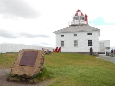
Cape Spear Lighthouse Marker
1 ► Newfoundland and Labrador, CensusDiv 1 - Avalon Peninsula-St. John's, Blackhead — Cape Spear Lighthouse — Le Phare du Cap Spear —  |
| On Blackhead Road. | |||
| 2 ► Newfoundland and Labrador, CensusDiv 1 - Avalon Peninsula-St. John's, Blackhead — World War II Battery — Batterie del a IIième Guerre mondaile — Fort Cape Spear / Le fort du cap Spear — |
| Near Blackhead Road. | |||
| 3 ► Newfoundland and Labrador, CensusDiv 1 - Avalon Peninsula-St. John's, Brigus — Captain Robert Abram Bartlett — Le Capitaine Robert Abram Bartlett — 1875-1946 — |
| On Middle Ridge, on the right when traveling south. | |||
| 4 ► Newfoundland and Labrador, CensusDiv 1 - Avalon Peninsula-St. John's, Brigus — Hawthorne Cottage / Cottage Hawthorne — |
| On South Street, on the left when traveling north. | |||
| 5 ► Newfoundland and Labrador, CensusDiv 1 - Avalon Peninsula-St. John's, Brigus — The Brigus Tunnel — |
| On Church Hill, on the right when traveling south. | |||
| 6 ► Newfoundland and Labrador, CensusDiv 1 - Avalon Peninsula-St. John's, Carbonear — CN Railway Station — c1917-1918 — |
| On Water Street, on the left when traveling north. | |||
| 7 ► Newfoundland and Labrador, CensusDiv 1 - Avalon Peninsula-St. John's, Carbonear — Former Carbonear Railway Station / L'Ancienne Gare de Carbonear — |
| On Water Street, on the left when traveling north. | |||
| 8 ► Newfoundland and Labrador, CensusDiv 1 - Avalon Peninsula-St. John's, Ferryland — Colony of Avalon — La colonie d’Avalon — Sir David Kirke, c. 1597-1654 — |
| Near Newfoundland and Labrador Route 10, on the right when traveling north. | |||
| 9 ► Newfoundland and Labrador, CensusDiv 1 - Avalon Peninsula-St. John's, Ferryland — The French Attack Ferryland — Les Français attaquent Ferryland — |
| Near Newfoundland and Labrador Route 10, on the right when traveling north. | |||
| 10 ► Newfoundland and Labrador, CensusDiv 1 - Avalon Peninsula-St. John's, Harbour Grace — Harbour Grace Court House / Palais de Justice D'Harbour Grace — |
| On Cathedral Street (Newfoundland and Labrador Route 70) at Harvey Street, on the left when traveling east on Cathedral Street. | |||
| 11 ► Newfoundland and Labrador, CensusDiv 1 - Avalon Peninsula-St. John's, Harbour Grace — Laurence Coughlan — |
| On Water Street East, on the right when traveling north. | |||
| 12 ► Newfoundland and Labrador, CensusDiv 1 - Avalon Peninsula-St. John's, Harbour Grace — Rothesay House, Munn/Godden Residence — Built 1855, reconstructed 1906 — |
| On Water Street West, on the left when traveling north. | |||
| 13 ► Newfoundland and Labrador, CensusDiv 1 - Avalon Peninsula-St. John's, Harbour Grace — Transatlantic Flights / Vols Transatlantiques — 1919-1937 — |
| On Water Street East, on the right when traveling north. | |||
| 14 ► Newfoundland and Labrador, CensusDiv 1 - Avalon Peninsula-St. John's, Harbour Grace, Harbour Grace South — Amelia Earhart — |
| On Water Street West, on the right when traveling north. | |||
| 15 ► Newfoundland and Labrador, CensusDiv 1 - Avalon Peninsula-St. John's, Harbour Grace, Harbour Grace South — Education & Confederation — |
| On Water Street West, on the right when traveling north. | |||
| 16 ► Newfoundland and Labrador, CensusDiv 1 - Avalon Peninsula-St. John's, Harbour Grace, Harbour Grace South — Otterbury Schoolhouse (Built circa 1884) / Preserving the Schoolhouse — |
| On Water Street West north of Harvey Street (Local Road 70), on the right when traveling north. | |||
| 17 ► Newfoundland and Labrador, CensusDiv 1 - Avalon Peninsula-St. John's, Heart's Content — Western Union Operator's House — Built circa 1921 — |
| On Newfoundland and Labrador Route 80, on the left when traveling north. | |||
| 18 ► Newfoundland and Labrador, CensusDiv 1 - Avalon Peninsula-St. John's, Placentia — (Fort Royal) — Outer Defences / Défenses avancées — |
| Near Castle Hill Road. | |||
| 19 ► Newfoundland and Labrador, CensusDiv 1 - Avalon Peninsula-St. John's, Placentia — Castle Hill — |
| On Castle Hill Road close to Route 100 South. | |||
| 20 ► Newfoundland and Labrador, CensusDiv 1 - Avalon Peninsula-St. John's, Placentia — Castle Hill — |
| On Castle Hill Road close to Route 100 South. | |||
| 21 ► Newfoundland and Labrador, CensusDiv 1 - Avalon Peninsula-St. John's, Placentia — Fort Frederick — |
| On Main Street (Route 100 South) close to Orcan Drive, on the left when traveling south. | |||
| 22 ► Newfoundland and Labrador, CensusDiv 1 - Avalon Peninsula-St. John's, Placentia — Fort Royal (Plaisance) — le fort Royal — |
| Near Castle Hill Road. | |||
| 23 ► Newfoundland and Labrador, CensusDiv 1 - Avalon Peninsula-St. John's, Placentia — Port Royal and Castle Graves / Port Royal et Castle Graves — |
| Near Castle Hill Road. | |||
| 24 ► Newfoundland and Labrador, CensusDiv 1 - Avalon Peninsula-St. John's, St. John's — (Royal Newfoundland Constabulary Monument) — |
| On Queens Road at Gower Street, in the median on Queens Road. | |||
| 25 ► Newfoundland and Labrador, CensusDiv 1 - Avalon Peninsula-St. John's, St. John's — 1892: The Great Fire — 1892: Le grand incendie — |
| Near Signal Hill Road. | |||
| 26 ► Newfoundland and Labrador, CensusDiv 1 - Avalon Peninsula-St. John's, St. John's — Bank of British North America — 1849 — |
| On Duckworth Street close to Soloman's Lane, on the left when traveling north. | |||
| 27 ► Newfoundland and Labrador, CensusDiv 1 - Avalon Peninsula-St. John's, St. John's — Battle of Signal Hill / La bataille de Signal Hill — |
| Near Signal Hill Road. | |||
| 28 ► Newfoundland and Labrador, CensusDiv 1 - Avalon Peninsula-St. John's, St. John's — Cabot Tower — La Tour Cabot — |
| Near Signal Hill Road. | |||
| 29 ► Newfoundland and Labrador, CensusDiv 1 - Avalon Peninsula-St. John's, St. John's — Fever Hospital — L’hôpital des maladies contagieuses — |
| On Signal Hill Road. | |||
| 30 ► Newfoundland and Labrador, CensusDiv 1 - Avalon Peninsula-St. John's, St. John's — First Transatlantic Wireless Signal — |
| On Signal Hill Road. | |||
| 31 ► Newfoundland and Labrador, CensusDiv 1 - Avalon Peninsula-St. John's, St. John's — Fishery — Le pêche — |
| Near Signal Hill Road. | |||
| 32 ► Newfoundland and Labrador, CensusDiv 1 - Avalon Peninsula-St. John's, St. John's — Former Bank of British North America — L’ancienne Bank of North America — |
| On Duckworth Street close to Soloman's Lane, on the left when traveling north. | |||
| 33 ► Newfoundland and Labrador, CensusDiv 1 - Avalon Peninsula-St. John's, St. John's — Former Newfoundland Railway Headquarters — L’ancien siège social du chemin de fer de Terre-Neuve — |
| On Water Street close to Job Street, on the left when traveling south. | |||
| 34 ► Newfoundland and Labrador, CensusDiv 1 - Avalon Peninsula-St. John's, St. John's — Gower Street United Church — Built 1894-1896 — |
| On Queen's Road at Church Hill, on the left when traveling south on Queen's Road. | |||
| 35 ► Newfoundland and Labrador, CensusDiv 1 - Avalon Peninsula-St. John's, St. John's — Herbert J. Russell, C.B.E. — |
| On Water Street close to Job Street, on the left when traveling south. | |||
| 36 ► Newfoundland and Labrador, CensusDiv 1 - Avalon Peninsula-St. John's, St. John's — Ice — Les Glaces — |
| Near Signal Hill Road. | |||
| 37 ► Newfoundland and Labrador, CensusDiv 1 - Avalon Peninsula-St. John's, St. John's — Mary Meager Southcott — (1862-1943) — |
| On Forest Road close to Taaffe's Lane, on the right when traveling west. | |||
| 38 ► Newfoundland and Labrador, CensusDiv 1 - Avalon Peninsula-St. John's, St. John's — Masonic Temple — 1894-1897 — |
| On Cathedral Street close to Gower Street, on the right when traveling west. | |||
| 39 ► Newfoundland and Labrador, CensusDiv 1 - Avalon Peninsula-St. John's, St. John's — Noon Day Gun — Canon de midi — |
| Near Signal Hill Road. | |||
| 40 ► Newfoundland and Labrador, CensusDiv 1 - Avalon Peninsula-St. John's, St. John's — O’Dwyer Block — 1847 — |
| On Water Street close to Beck's Cove, on the right when traveling north. | |||
| 41 ► Newfoundland and Labrador, CensusDiv 1 - Avalon Peninsula-St. John's, St. John's — Peacetime Use — Utilisation en temps de paix — |
| Near Signal Hill Road. | |||
| 42 ► Newfoundland and Labrador, CensusDiv 1 - Avalon Peninsula-St. John's, St. John's — Sir Robert Gillespie Reid — |
| On Water Street close to Job Street, on the left when traveling south. | |||
| 43 ► Newfoundland and Labrador, CensusDiv 1 - Avalon Peninsula-St. John's, St. John's — St. John the Baptist Anglican Cathedral — Cathédrale Anglicane St. John the Baptist — |
| On Church Hill close to Gower Street, on the right when traveling north. | |||
| 44 ► Newfoundland and Labrador, CensusDiv 1 - Avalon Peninsula-St. John's, St. John's — St. John’s Court House — Le Palais de justice de St. John’s — |
| On Water Street close to McMurdo's Lane, on the left when traveling north. | |||
| 45 ► Newfoundland and Labrador, CensusDiv 1 - Avalon Peninsula-St. John's, St. John's — Swiling — La chasse au phoque — |
| Near Signal Hill Road. | |||
| 46 ► Newfoundland and Labrador, CensusDiv 1 - Avalon Peninsula-St. John's, St. John's — Thompson Building — c 1847 — |
| On Water Street close to Beck's Cove, on the right when traveling north. | |||
| 47 ► Newfoundland and Labrador, CensusDiv 1 - Avalon Peninsula-St. John's, St. John's — Transatlantic Radio Signals — Le premier message radiotélégraphique transatlantique — |
| On Signal Hill Road. | |||
| 48 ► Newfoundland and Labrador, CensusDiv 1 - Avalon Peninsula-St. John's, St. John's — William Carson — 1770-1843 — |
| On Duckworth Street at Cathedral Street, on the left when traveling north on Duckworth Street. | |||
| 49 ► Newfoundland and Labrador, CensusDiv 1 - Avalon Peninsula-St. John's, St. John's, Central St. John's — Government House / Résidence Du Lieutenant-Gouverneur — |
| On Military Road, on the left when traveling east. | |||
| 50 ► Newfoundland and Labrador, CensusDiv 1 - Avalon Peninsula-St. John's, St. John's, Central St. John's — Harris Cottage — Built circa 1833 — |
| On Monkstown Road, on the right when traveling east. | |||
| 51 ► Newfoundland and Labrador, CensusDiv 1 - Avalon Peninsula-St. John's, St. John's, Central St. John's — Rennie's Mill Road Historic District / Le District Historique de Rennie's Mill Road — |
| On Rennies Mill Road. | |||
| 52 ► Newfoundland and Labrador, CensusDiv 1 - Avalon Peninsula-St. John's, St. John's, Downtown — 28 Cochrane Street — Built circa 1893 — |
| On 28 Cochrane Street at York Street, on the right when traveling north on 28 Cochrane Street. | |||
| 53 ► Newfoundland and Labrador, CensusDiv 1 - Avalon Peninsula-St. John's, St. John's, Downtown — 32 Queen's Road — c1854-1875 — |
| On Queens Road, on the left when traveling north. | |||
| 54 ► Newfoundland and Labrador, CensusDiv 1 - Avalon Peninsula-St. John's, St. John's, Downtown — Anderson House — Built circa 1804 — |
| On Powers Court at Signal Hill Road, on the right when traveling west on Powers Court. | |||
| 55 ► Newfoundland and Labrador, CensusDiv 1 - Avalon Peninsula-St. John's, St. John's, Downtown — Apothecary Hall — 1922 — |
| On Water Street at Brennan Street, on the right when traveling south on Water Street. | |||
| 56 ► Newfoundland and Labrador, CensusDiv 1 - Avalon Peninsula-St. John's, St. John's, Downtown — Bannerman House — 1840-1849 — |
| On Bannerman Street, on the left when traveling south. | |||
| 57 ► Newfoundland and Labrador, CensusDiv 1 - Avalon Peninsula-St. John's, St. John's, Downtown — Fort Townshend — |
| On Harvey Road near Bonaventure Avenue, on the right when traveling south. | |||
| 58 ► Newfoundland and Labrador, CensusDiv 1 - Avalon Peninsula-St. John's, St. John's, Downtown — Fort William / Le Fort William — |
| On Cavendish Square at Duckworth Street, on the right when traveling north on Cavendish Square. | |||
| 59 ► Newfoundland and Labrador, CensusDiv 1 - Avalon Peninsula-St. John's, St. John's, Downtown — John Reeves — (1752-1829) — |
| On Duckworth Street at Church Hill, on the right when traveling north on Duckworth Street. | |||
| 60 ► Newfoundland and Labrador, CensusDiv 1 - Avalon Peninsula-St. John's, St. John's, Downtown — Sir Humphrey Gilbert — ca. 1537-1583 — |
| On Water Street. | |||
| 61 ► Newfoundland and Labrador, CensusDiv 1 - Avalon Peninsula-St. John's, St. John's, Downtown — The Newfoundland National War Memorial — Le Monument Commémoratif National de Guerre de Terre-Neuve — |
| On Water Street at Queens Cove, on the left when traveling north on Water Street. | |||
| 62 ► Newfoundland and Labrador, CensusDiv 1 - Avalon Peninsula-St. John's, St. John's, Quidi Vidi — Christ Church — Built 1842 — |
| On Quidi Vidi Village Road, on the right when traveling north. | |||
| 63 ► Newfoundland and Labrador, CensusDiv 1 - Avalon Peninsula-St. John's, St. John's, Quidi Vidi — Christ Church — |
| On Quidi Vidi Village Road, on the right when traveling north. | |||
| 64 ► Newfoundland and Labrador, CensusDiv 1 - Avalon Peninsula-St. John's, St. John's, Quidi Vidi — Mallard Cottage / La Maison Mallard — |
| On Barrows Road, on the left when traveling south. | |||
| 65 ► Newfoundland and Labrador, CensusDiv 1 - Avalon Peninsula-St. John's, St. John's, St John's — Anderson House — c1804-1805 — |
| On Powers Court at Signal Hill Road, on the right when traveling west on Powers Court. | |||
| 66 ► Newfoundland and Labrador, CensusDiv 1 - Avalon Peninsula-St. John's, Trepassey, Ferryland — Ferryland — Population 717 (1996) — Settled 1621 • Inc. 1971 — |
| On Newfoundland and Labrador Route 10, on the left when traveling north. | |||
| 67 ► Newfoundland and Labrador, CensusDiv 6 - Central Nfld-Grand Falls-Windsor, Gander — Arrow Air Crash — The Silent Witness Memorial — Cross of Sacrifice — |
| On Silent Witness Memorial Road close to Trans-Canada Highway (Route 1), on the right when traveling south. | |||