535 entries match your criteria. The first 100 are listed. ⊳
Historical Markers and War Memorials
in the New River Gorge Region
By Roger Miller, October 30, 2016
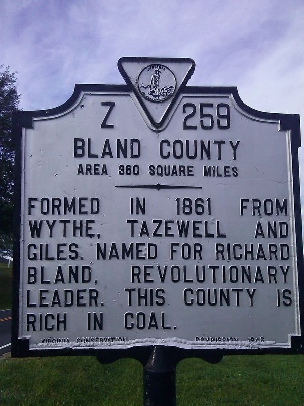
Giles County/Bland County Marker
1 ► Virginia, Giles County, Bland — Z-259 — Giles County / Bland County — Area 369 square miles / Area 360 square miles —  |
| On Walkers Creek Valley Road (Virginia Route 42) 1.6 miles west of Flat Hollow Road ( Route 670), on the right when traveling west. | |||
| 2 ► Virginia, Giles County, Eggleston — KB-56 — Eggleston's Springs — |
| On Eggleston Road (Virginia Route 730) at Cliffview Street ( Route 612), on the right when traveling west on Eggleston Road. | |||
| 3 ► Virginia, Giles County, Glen Lyn — Z-211 — West Virginia / Giles County Virginia — / Area 369 Square Miles — |
| On Virginia Avenue (U.S. 460) 0.1 miles south of Ball Avenue (State Road 648), on the right when traveling north. | |||
| 4 ► Virginia, Giles County, Midway — Z-289 — Giles County / West Virginia — |
| On Federal Street (U.S. 219) just south of Giles-Fayette-Kanawa Turnpike (in WV) (Route 24/8), on the right when traveling south. | |||
| 5 ► Virginia, Giles County, Narrows — KG-22 — Narrows — |
| On MacArthur Lane (Virginia Route 61) just south of Princeton Lane (Lurich Road) (County Route 649), on the left when traveling south. | |||
| 6 ► Virginia, Giles County, Narrows — KG-19 — New River — |
| On Virginia Avenue (U.S. 460), on the right when traveling east. | |||
| 7 ► Virginia, Giles County, Narrows — World Wars I & II Memorial — 🦅 — |
| On Main Street (Virginia Route 100) at Monroe Street ( Route 61), on the left when traveling east on Main Street. | |||
| 8 ► Virginia, Giles County, Pearisburg — Andrew Johnston House — 208 North Main Street — |
| On North Main Street. | |||
| 9 ► Virginia, Giles County, Pearisburg — KG-20 — First Court of Giles County — |
| On Virginia Avenue (U.S. 460) 2.2 miles west of Thomas Drive, on the right when traveling west. | |||
| 10 ► Virginia, Giles County, Pearisburg — Giles County Confederate Monument — |
| On North Main Street (Business U.S. 460) at Wenonah Avenue, on the right when traveling north on North Main Street. | |||
| 11 ► Virginia, Giles County, Pearisburg — Giles County War Memorial — |
| On Wenonah Avenue (Business U.S. 460) at North Main Street, on the right when traveling west on Wenonah Avenue. | |||
| 12 ► Virginia, Giles County, Pearisburg — Grist Mill Stones — |
| Near North Main Street (Business U.S. 460), on the right when traveling north. | |||
| 13 ► Virginia, Giles County, Pearisburg — McClaugherty Mill Stone — |
| On North Main Street (Business U.S. 460) north of Wenonah Avenue, on the right when traveling north. | |||
| 14 ► Virginia, Giles County, Pearisburg — KG-21 — Pearisburg — |
| On North Main Street (Business U.S. 460) at Wenonah Avenue (Business U.S. 460), on the right when traveling north on North Main Street. | |||
| 15 ► Virginia, Giles County, Pearisburg — Revolutionary War Soldiers — Giles County — |
| On Wenonah Avenue (Business U.S. 460) at North Main Street, on the left when traveling east on Wenonah Avenue. | |||
| 16 ► Virginia, Giles County, Pearisburg — Stepping Stone — |
| Near North Main Street (Business U.S. 460) at Mountain Lake Avenue, on the right when traveling north. | |||
| 17 ► Virginia, Giles County, Pearisburg — Thomas Farley, Sr. — |
| On Pulaski Giles Highway (Virginia Route 100) at Bane Road, on the left when traveling north on Pulaski Giles Highway. | |||
| 18 ► Virginia, Giles County, Pembroke — KG-14 — Camp John J. Pershing — Civilian Conservation Corps Company 1370-2386 — |
| On Virginia Avenue (U.S. 460) at Snidow Street, on the right when traveling east on Virginia Avenue. | |||
| 19 ► Virginia, Giles County, Pembroke — Snidow Pioneers — |
| On Cascade Drive (County Route T-623) at Virginia Avenue (U.S. 460), on the right when traveling south on Cascade Drive. | |||
| 20 ► Virginia, Giles County, Pembroke — Welcome to Cascades — A Walk Into the Past — |
| On Cascade Drive, on the right when traveling north. | |||
| 21 ► Virginia, Giles County, Ripplemead — KG-17 — Snidow's Ferry — |
| On Virginia Avenue (U.S. 460) 0.4 miles west of Big Stony Creek Road ( Road 635), on the right when traveling west. | |||
| 22 ► Virginia, Giles County, Staffordsville — Z-258 — Giles County / Pulaski County — |
| On Pulaski Giles Turnpike (Virginia Route 100) 0.3 miles north of Little Creek Road ( Route 601), on the right when traveling north. | |||
| 23 ► Virginia, Giles County, Staffordsville — KG-15 — Mountain Evangelist — |
| On Eggleston Road (Virginia Route 730) at Redbud Lane, on the right when traveling east on Eggleston Road. | |||
| 24 ► Virginia, Giles County, Staffordsville — KG-16 — Old-Fashioned Camp Meeting — |
| On Pulaski Giles Turnpike (Virginia Route 100) 0.3 miles south of Big Rock Road ( Route 692), on the right when traveling north. | |||
| 25 ► Virginia, Montgomery County, Blacksburg — Coal Car — |
| Near Merrimac Road at Route 701, on the left when traveling north. | |||
| 26 ► Virginia, Montgomery County, Blacksburg — Coal Car Hoist — |
| Near Merrimac Road at County Route 701, on the left when traveling north. | |||
| 27 ► Virginia, Montgomery County, Blacksburg — Hoist Foundation — |
| Near Merrimac Road at Route 701, on the left when traveling north. | |||
| 28 ► Virginia, Montgomery County, Blacksburg — KG-25 — Price's Fork — |
| On Prices Fork Road (Virginia Route 685) east of Thomas Lane ( Route 737), on the right when traveling west. | |||
| 29 ► Virginia, Montgomery County, Blacksburg — The Commissary — |
| Near Merrimac Road at Route 701, on the left when traveling north. | |||
| 30 ► Virginia, Montgomery County, Blacksburg — The Hotel — |
| Near Merrimac Road at Route 701, on the left when traveling north. | |||
| 31 ► Virginia, Montgomery County, Blacksburg — The Tipple — |
| Near Merrimac Road at Route 701, on the left when traveling north. | |||
| 32 ► Virginia, Montgomery County, Blacksburg — I-2-a — Virginia Polytechnic Institute and State University — |
| On Pandapas Pond Road (U.S. 460) at Forest Service Road (Road P188-2), on the right when traveling east on Pandapas Pond Road. | |||
| 33 ► Virginia, Montgomery County, Blacksburg, Downtown — Alexander Black House — 1897 — |
| On Draper Road SW south of Lee Street SW, on the right when traveling south. | |||
| 34 ► Virginia, Montgomery County, Blacksburg, Downtown — Blacksburg Motor Company Building 1924 — |
| On South Main Street (Business U.S. 460) at Clay Street SW, on the left when traveling west on South Main Street. | |||
| 35 ► Virginia, Montgomery County, Blacksburg, Downtown — Five Chimneys — 1852 — |
| On Draper Road Southwest north of Clay Street Southwest, on the left when traveling north. | |||
| 36 ► Virginia, Montgomery County, Blacksburg, Downtown — The Armory — 1936 — |
| On Draper Road NW at Jackson Street NW, on the right when traveling south on Draper Road NW. | |||
| 37 ► Virginia, Montgomery County, Blacksburg, Downtown — The Cellar Building — Ca. 1890 — |
| On College Avenue Extension at North Main Street (Business U.S. 460), on the right when traveling west on College Avenue Extension. | |||
| 38 ► Virginia, Montgomery County, Blacksburg, Downtown — Thomas-Conner House — 1878 — |
| On Draper Road SW at Wall Street, on the right when traveling south on Draper Road SW. | |||
| 39 ► Virginia, Montgomery County, Blacksburg, Downtown — KG-24 — William Black — |
| On North Main Street (Business U.S. 460) at Jackson Street NE ( Route 785), on the right when traveling north on North Main Street. | |||
| 40 ► Virginia, Montgomery County, Blacksburg, Downtown Eastside — To the Memory of the Confederate Dead — |
| Near Jackson Street Northeast at Owens Street Northeast. | |||
| 41 ► Virginia, Montgomery County, Blacksburg, Downtown Eastside — Westview Cemetery — Confederate and Union Burial Ground — |
| Near Owens Street at East Roanoke Street, on the right when traveling west. | |||
| 42 ► Virginia, Montgomery County, Blacksburg, Hethwood - Prices Fork — Restoring Stroubles Creek — |
| Near Stroubles Creek Road south of Foxridge Lane. | |||
| 43 ► Virginia, Montgomery County, Blacksburg, Mountain View — Eastern Continental Divide & 1763 Proclamation Line — |
| On South Main Street (Business U.S. 460) at Graves Avenue, on the right when traveling west on South Main Street. | |||
| 44 ► Virginia, Montgomery County, Blacksburg, University — 1820 Slave Cabin — Historic Smithfield Plantation — |
| On Smithfield Plantation Road 0.1 miles Smithfield Road, on the right when traveling south. | |||
| 45 ► Virginia, Montgomery County, Blacksburg, University — April 16th Memorial — We Remember — |
| Near Drillfield Drive 0.1 miles west of Stanger Street. | |||
| 46 ► Virginia, Montgomery County, Blacksburg, University — Carol Montgomery Newman — (1879-1941) — |
| On Drillfield Drive at College Street, on the right when traveling north on Drillfield Drive. | |||
| 47 ► Virginia, Montgomery County, Blacksburg, University — Charles Henry Burchard — (1915-1990) — |
| Near West Turner Street west of Stanger Street. | |||
| 48 ► Virginia, Montgomery County, Blacksburg, University — Clinton Harriman Cowgill — (1897-1975) — |
| Near West Turner Street west of Stanger Street. | |||
| 49 ► Virginia, Montgomery County, Blacksburg, University — Earl Bertram Norris — (1882-1966) — |
| Near Drillfield Drive west of Stanger Street. | |||
| 50 ► Virginia, Montgomery County, Blacksburg, University — Enslaved People and the Prestons / From Plantation to College Campus — |
| Near West Campus Drive at Drillfield Drive, on the right when traveling south. | |||
| 51 ► Virginia, Montgomery County, Blacksburg, University — Frank Leigh Robeson — (1884-1974) — |
| Near West Campus Drive north of Drillfield Drive. | |||
| 52 ► Virginia, Montgomery County, Blacksburg, University — Frederick Dewey Durham — (1899-1998) — |
| On Barger Street west of Stanger Street, on the right when traveling west. | |||
| 53 ► Virginia, Montgomery County, Blacksburg, University — George Burke Johnston — (1907 - 1995) — |
| Near West Campus Drive at Perry Street. | |||
| 54 ► Virginia, Montgomery County, Blacksburg, University — Harvey Lee Price — (1874-1951) — |
| On Drillfield Drive 0.1 miles east of West Campus Drive, on the right when traveling east. | |||
| 55 ► Virginia, Montgomery County, Blacksburg, University — John Edward Williams — (1867-1943) — |
| On Drillfield Drive 0.1 miles east of Greenhouse Road, on the right when traveling west. | |||
| 56 ► Virginia, Montgomery County, Blacksburg, University — John Houston Squires — (1882-1934) — |
| On Alumni Mall (Virginia Route 314) west of North Main Street (Business U.S. 460), on the right when traveling east. | |||
| 57 ► Virginia, Montgomery County, Blacksburg, University — John McLaren McBryde — (1841-1923) — |
| On Stanger Street north of Drillfield Drive, on the left when traveling north. | |||
| 58 ► Virginia, Montgomery County, Blacksburg, University — John Redd Hutcheson — (1886-1962) — |
| On Drillfield Drive 0.1 miles east of West Campus Drive, on the right when traveling east. | |||
| 59 ► Virginia, Montgomery County, Blacksburg, University — John William Hancock Jr. — (1904-1994) — |
| Near West Turner Street west of Stanger Street. | |||
| 60 ► Virginia, Montgomery County, Blacksburg, University — Julian Ashby Burruss — (1876-1947) — President 1919-1945 — |
| On Drillfield Drive 0.2 miles east of Greenhouse Road, on the right when traveling west. | |||
| 61 ► Virginia, Montgomery County, Blacksburg, University — Lingan Strother Randolph — (1868-1922) — |
| Near West Turner Street west of Stanger Street. | |||
| 62 ► Virginia, Montgomery County, Blacksburg, University — KG-10 — Mary Draper Ingels — |
| On Duckpond Drive near W Campus Drive, on the right when traveling south. | |||
| 63 ► Virginia, Montgomery County, Blacksburg, University — Native Stewardship / The Monacan Peoples — |
| Near West Campus Drive at Drillfield Drive, on the left when traveling north. | |||
| 64 ► Virginia, Montgomery County, Blacksburg, University — Paul Ernest Torgersen — (1931- ) — |
| On Stanger Street at VPI Mall, on the right when traveling north on Stanger Street. | |||
| 65 ► Virginia, Montgomery County, Blacksburg, University — Paul Neyron Derring — (1894-1973) — |
| Near West Campus Drive at Perry Street. | |||
| 66 ► Virginia, Montgomery County, Blacksburg, University — People and Place / Land Grant College — |
| On Alumni Mall (Business U.S. 460) west of North Main Street, on the right when traveling west. | |||
| 67 ► Virginia, Montgomery County, Blacksburg, University — Revolutionary War Patriots — |
| Near Smithfield Plantation Road 0.1 miles south of Smithfield Road. | |||
| 68 ► Virginia, Montgomery County, Blacksburg, University — Robert James Davidson — (1862-1915) Professor 1891-1915 — Dean, Scientific Department 1903-1913 Dean, Department of Applied Science 1913-1915 — |
| On Drillfield Drive 0.1 miles east of Greenhouse Road, on the right when traveling west. | |||
| 69 ► Virginia, Montgomery County, Blacksburg, University — Roy Jay Holden — (1870-1945) — |
| Near Stanger Street north of Drillfield Drive. | |||
| 70 ► Virginia, Montgomery County, Blacksburg, University — Site Of The Law Offices Of Wm. Ballard Preston — Historic Smithfield Plantation — |
| Near Smithfield Plantation Road 0.2 miles Smithfield Road, on the right when traveling south. | |||
| 71 ► Virginia, Montgomery County, Blacksburg, University — Slaves' Garden — Historic Smithfield Plantation — |
| Near Smithfield Plantation Road 0.1 miles south of Smithfield Road, on the right when traveling south. | |||
| 72 ► Virginia, Montgomery County, Blacksburg, University — Smithfield Plantation — Historic Smithfield Plantation — |
| Near Smithfield Plantation Road 0.2 miles south of Smithfield Road, on the right when traveling south. | |||
| 73 ► Virginia, Montgomery County, Blacksburg, University — I-20 — Solitude — |
| On Greenhouse Drive at Drillfield Drive, on the right when traveling south on Greenhouse Drive. | |||
| 74 ► Virginia, Montgomery County, Blacksburg, University — Student Diversity — |
| Near Kent Street south of Drillfield Drive, on the right when traveling south. | |||
| 75 ► Virginia, Montgomery County, Blacksburg, University — The Alwood Oak — Dedicated October 14, 2011 in tribute to William Bradford Alwood — |
| On Drillfield Drive, on the left when traveling west. | |||
| 76 ► Virginia, Montgomery County, Blacksburg, University — The Early Years / Campus Over Time — |
| On Alumni Mall west of North Main Street (Business U.S. 460), on the right when traveling east. | |||
| 77 ► Virginia, Montgomery County, Blacksburg, University — The Stroubles Creek Watershed and the Duck Pond — |
| Near Duckpond Drive near Smithfield Road. | |||
| 78 ► Virginia, Montgomery County, Blacksburg, University — Theodorick Pryor Campbell — (1861-1928) — |
| On Drillfield Drive 0.2 miles south of Kent Street, on the right when traveling north. | |||
| 79 ► Virginia, Montgomery County, Blacksburg, University — Thomas Barksdale Hutcheson — (1882-1950) — |
| On Drillfield Drive 0.1 miles east of West Campus Drive, on the right when traveling east. | |||
| 80 ► Virginia, Montgomery County, Blacksburg, University — Thomas Marshall Hahn Jr. — (1926- ) — |
| Near West Campus Drive east of Duckpond Road. | |||
| 81 ► Virginia, Montgomery County, Blacksburg, University — Thomas Oldham Sandy — (1857-1919) — State Demonstration Agent 1907-1917 — |
| On Drillfield Drive 0.1 miles east of West Campus Drive, on the right when traveling east. | |||
| 82 ► Virginia, Montgomery County, Blacksburg, University — Time Capsule — Virginia Tech 150 (1872-2022) — |
| On Drillfield Drive 0.1 miles south of Stanger Street, on the right when traveling south. | |||
| 83 ► Virginia, Montgomery County, Blacksburg, University — I 2d — Virginia Polytechnic Institute and State University — |
| On Alumni Mall (Virginia Route 314) at North Main Street (Business U.S. 460), on the right when traveling west on Alumni Mall. | |||
| 84 ► Virginia, Montgomery County, Blacksburg, University — I-23 — Virginia Tech Airport — |
| On Tech Center Drive 0.1 miles east of Kraft Drive, on the right when traveling west. | |||
| 85 ► Virginia, Montgomery County, Blacksburg, University — Virginia Tech War Memorial Chapel — "That I May Serve" — |
| On Drillfield Drive at Alumni Mall ( Route 314), on the left when traveling north on Drillfield Drive. | |||
| 86 ► Virginia, Montgomery County, Blacksburg, University — William Addison Caldwell — |
| Near Stanger Street 0.1 miles north of Drillfield Drive, on the right when traveling north. | |||
| 87 ► Virginia, Montgomery County, Blacksburg, University — William Bradford Alwood — (1845 - 1946) — |
| On Drillfield Drive, on the right when traveling west. | |||
| 88 ► Virginia, Montgomery County, Blacksburg, University — William Frank Henderson — (1853-1935) — |
| Near Alumni Mall (Virginia Route 314) west of North Main Street (Business U.S. 460). | |||
| 89 ► Virginia, Montgomery County, Blacksburg, University — William MacFarland Patton — (1845-1905) — |
| On Drillfield Drive west of Alumni Mall, on the left when traveling west. | |||
| 90 ► Virginia, Montgomery County, Blacksburg, University — Women's History / Women on Campus — |
| On Drillfield Drive at Kent Street, on the right when traveling north on Drillfield Drive. | |||
| 91 ► Virginia, Montgomery County, Blacksburg, Virginia Tech — Cemetery Landscape — Historic Smithfield Plantation — |
| Near Smithfield Plantation Road 0.2 miles south of Smithfield Road, on the left when traveling south. | |||
| 92 ► Virginia, Montgomery County, Blacksburg, Virginia Tech — K-64 — Founding of the Future Farmers of Virginia — |
| On Southgate Drive north of Bypass U.S. 460, on the right when traveling north. | |||
| 93 ► Virginia, Montgomery County, Blacksburg, Virginia Tech — Liberty and Justice for All — |
| On Smithfield Plantation Road 0.1 miles south of Smithfield Road. | |||
| 94 ► Virginia, Montgomery County, Blacksburg, Virginia Tech — Preston Cemetery — Historic Smithfield Plantation — |
| Near Smithfield Plantation Road south of Smithfield Road. | |||
| 95 ► Virginia, Montgomery County, Blacksburg, Virginia Tech — KG-9 — Smithfield — |
| On Southgate Drive north of Bypass U.S. 460, on the right when traveling north. | |||
| 96 ► Virginia, Montgomery County, Blacksburg, Virginia Tech — Smithfield Blacksmith Shop — Historic Smithfield Plantation — |
| On Smithfield Plantation Road, on the right when traveling south. | |||
| 97 ► Virginia, Montgomery County, Blacksburg, Virginia Tech — KG-27 — Virginia 4-H State Congress — |
| On Southgate Drive north of Bypass U.S. 460, on the right when traveling north. | |||
| 98 ► Virginia, Montgomery County, Blacksburg, Virginia Tech — I 2-e — Virginia Polytechnic Institute and State University — |
| On Southgate Drive north of Bypass U.S. 460, on the right when traveling north. | |||
| 99 ► Virginia, Montgomery County, Blacksburg, Virginia Tech — William Ballard Preston — The Preston Resolution — |
| Near Smithfield Plantation Road 0.1 miles south of Smithfield Road. | |||
| 100 ► Virginia, Montgomery County, Christiansburg — K-72 — Christiansburg — |
| On Roanoke Street (U.S. 11) 0.1 miles east of Depot Street ( Route 111), on the right when traveling south. | |||
535 entries matched your criteria. The first 100 are listed above. Next 100 ⊳