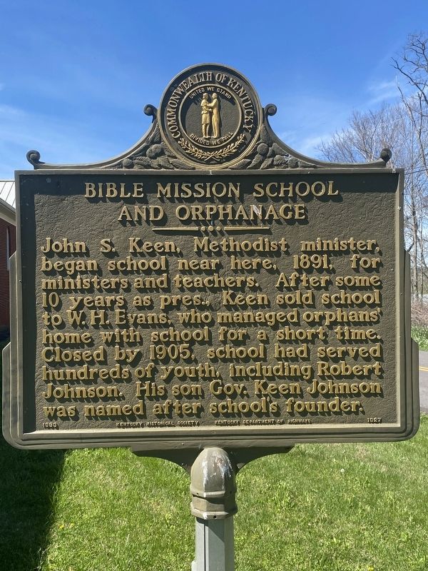
By Darren Jefferson Clay, April 6, 2024
Bible Mission School / Bible Mission School and Orphanage Marker
GEOGRAPHIC SORT Title Sort Marker Number Sort Marker Number Sort for Trails Publication Order Sort Publication Order Sort A Erected Year Sort Most Viewed Sort Most Recent-Interest Sort Most Recently Changed Sort SEE FAQ #33 FOR DESCRIPTIONS
On State Highway 1351 at Groce Gibson Road, on the left when traveling south on State Highway 1351.
On Cumberland Street at South Cross Street, on the left when traveling west on Cumberland Street.
Near Clear Fork Road 0.1 miles east of County Road 1150K, on the left when traveling east.
On North Washington Street at Cumberland Street, on the left when traveling north on North Washington Street.
On Jefferson Street at South Cross Street (Business U.S. 127), on the left when traveling east on Jefferson Street.
Near South Clearfork Road 0.3 miles north of Cedar Knob Road (Kentucky Route 969), on the right when traveling north. Reported missing.
On North Washingtgon Street at Jefferson Street, on the left when traveling north on North Washingtgon Street.
On Seventy Six Falls Road (State Road 1062) west of Morris Thomas Road, on the right when traveling north.
On Cumberland Falls Road (Kentucky Route 90), on the left when traveling west.
On Moonbow Trail west of Cumberland Falls Road, on the right when traveling north.
On Cumberland Falls Road (Kentucky Route 90), on the right when traveling east.
On Cumberland Falls Road (Kentucky Route 90), on the left when traveling west. Reported missing.
On U.S. 27 at Old U.S. 27 (State Highway 92), on the right when traveling south on U.S. 27.
On Henderson Street at Golf Course Road, on the left when traveling east on Henderson Street.
On Kentucky Route 1651 at Kinne Street, on the left when traveling south on Kentucky Route 1651.
Paid Advertisement
On Henderson Street at Golf Course Road, on the left when traveling east on Henderson Street.
On Henderson Street at Route 1651, on the right when traveling east on Henderson Street.
On Main Street (Kentucky Route 1651) at Gary Street, on the right when traveling south on Main Street.
On Main Street (Kentucky Route 1651) at Court Street/Geary Avenue, on the right when traveling south on Main Street.
Near Main Street (U.S. 27) south of West Lakeshore Drive, on the right when traveling south.
On Main Street (U.S. 27) at East French Avenue, on the right when traveling north on Main Street.
On Main Street (U.S. 27) north of French Avenue, on the left when traveling north.
On West Lakeshore Drive west of West French Avenue, on the left when traveling west.
Near Bobtown Road (State Road 80) 0.2 miles east of State Route 235, on the left when traveling east. Reported permanently removed.
Near State Road 235 0.1 miles south of State Route 761, on the left when traveling south. Reported permanently removed.
Near Kentucky Route 235 0.1 miles south of Route 761, on the left when traveling south.
Near Kentucky Route 235 south of McGlothin Road, on the right when traveling south. Reported permanently removed.
Near Route 235 south of McGlothin Road, on the right when traveling south.
Near Kentucky Route 235 0.1 miles south of Route 761, on the left when traveling south. Reported permanently removed.
On Kentucky Route 235 south of Route 761, on the right when traveling north.
Near State Highway 80 0.3 miles east of State Highway 235, on the left when traveling east.
Paid Advertisement
Near State Highway 80 0.2 miles State Highway 235, on the left when traveling east.
Near Kentucky Route 235 0.1 miles Route 761, on the left when traveling south.
On Kentucky Route 235 0.6 miles south of Burton Road, on the left when traveling south.
Near State Road 235 0.1 miles south of State Route 761, on the left when traveling south.
Near State Road 235 0.1 miles south of State Road 761, on the left when traveling south.
Near Kentucky Route 235 south of Route 761, on the left when traveling south.
Near Kentucky Route 235 0.1 miles south of Route 761, on the left when traveling south. Reported permanently removed.
On Kentucky Route 235 0.1 miles south of Route 761, on the left when traveling south.
Near State Highway 80 0.3 miles east of State Highway 235, on the left when traveling east.
On Kentucky Route 235 0.8 miles south of Route 761, on the right when traveling south.
Near Kentucky Route 235 0.1 miles south of Route 761.
Near Kentucky Route 235 0.1 miles south of Route 761, on the left when traveling south.
On Kentucky Route 235 0.1 miles south of Route 761, on the left when traveling south.
On Kentucky Route 235 0.1 miles south of Route 761, on the left when traveling south.
Near Kentucky Route 235 0.1 miles south of Route 761, on the left when traveling south. Reported permanently removed.
Near Kentucky Route 235 south of Route 761, on the left when traveling south.
Paid Advertisement
Near State Highway 235 0.1 miles south of State Route 761, on the left when traveling south.
Near Kentucky Route 235 0.1 miles south of Road 761, on the left when traveling south. Reported permanently removed.
Near Kentucky Route 235 south of Route 761, on the left when traveling south.
On Kentucky Route 235 0.1 miles south of Route 761, on the left when traveling south.
Near State Highway 80 0.2 miles east of State Highway 235, on the left when traveling east.
Near State Road 235 0.1 miles south of State Road 761, on the left when traveling south. Reported permanently removed.
On Mill Springs-Battlefield Road 0.3 miles south of Muskett Road, on the right when traveling south.
Near Kentucky Route 235 0.3 miles south of Route 761, on the left when traveling south.
On Sellars Road at Mill Springs-Battlefield Road, on the right when traveling east on Sellars Road.
Near Kentucky Route 235 0.1 miles south of Route 761, on the left when traveling south.
Near Kentucky Route 235 0.1 miles south of Route 761, on the left when traveling south. Reported permanently removed.
Near Kentucky Route 235 south of Route 761, on the left when traveling south.
On Kentucky Route 235 0.3 miles south of Route 761, on the left when traveling south.
Near State Road 235 0.1 miles south of State Road 761, on the left when traveling south.
Near Kentucky Route 235 0.1 miles Route 761, on the left when traveling south.
Near State Road 235 0.1 miles south of State Road 761, on the left when traveling south. Reported permanently removed.
Paid Advertisement
Near Kentucky Route 235 0.1 miles south of Route 761, on the left when traveling south.
On Route 235 1.7 miles south of Route 761, on the left when traveling south. Reported permanently removed.
On Kentucky Route 235 0.4 miles south of Route 761, on the left when traveling south.
Near Kentucky Route 235 0.1 miles Route 761, on the left when traveling south.
Near U.S. 39 south of Wayne Pierce Street, on the right when traveling south.
On Kentucky Route 39 south of Wayne Pierce Street, on the right when traveling north.
On East Oak Street at North Central Avenue, on the left when traveling east on East Oak Street.
On North Main Street at East Columbia Street, on the right when traveling north on North Main Street.
On South Vine Street north of Elm Street, on the left when traveling north.
On Cumberland Parkway (State Highway 80) at State Highway 1674, on the right when traveling east on Cumberland Parkway.
On South Vine Street north of Elm Street, on the left when traveling north.
On Kentucky 379 at Road 1058, on the right when traveling north on Kentucky 379.
On North Main Street (Business U.S. 127) at East Cumberland Avenue ( Route 619), in the median on North Main Street.
On South Main Street (Kentucky Route 92) at Lewis Alley, on the right when traveling south on South Main Street.
On South Main Street (Kentucky Route 92) at Lewis Alley, on the right when traveling south on South Main Street.
Paid Advertisement
On Main Street (Kentucky Route 379) at Jamestown Street ( Route 430), on the right when traveling north on Main Street.
On U.S. Highway 127 (U.S. 127) at State Route 76, on the right when traveling south on U.S. Highway 127.
On Kentucky Route 1275 at Old Mill Springs Road, on the right when traveling west on Kentucky Route 1275.
On Kentucky Route 1275 at Mill Springs - Gap of the Ridge Road, on the left when traveling west on Kentucky Route 1275.
On Kentucky Route 1275 at Mill Springs Battlefield Road, on the right when traveling west on Kentucky Route 1275.
On Kentucky Route 1275 at Old Mill Springs Road, on the right when traveling west on Kentucky Route 1275.
Near Kentucky Route 1275 at Old Mill Springs Road, on the right when traveling west.
On Old Mill Springs Road 1.2 miles south of Route 1275, on the left when traveling south.
On Old Mill Springs Road 1.2 miles south of Route 1275, on the right when traveling north.
On Court Street at North Main Street, on the left when traveling west on Court Street.
On North Main Street at Court Street, on the right when traveling south on North Main Street.
On South Main Street (Kentucky Route 167) at College Street, on the right when traveling south on South Main Street.
On North Main Street at Court Street, on the left when traveling north on North Main Street.
On Columbia Avenue (Kentucky Route 92) at South Main Street, in the median on Columbia Avenue.
On Mill Springs Battlefield Road 3 miles south of Route 235, on the right when traveling south.
Near Mill Springs Battlefield Road 3 miles south of Route 235, on the right when traveling south.
Paid Advertisement
On Mill Springs Battlefield Road 2.3 miles south of State Route 235, on the right when traveling south. Reported permanently removed.
On Mill Springs Battlefield Road at Sellars Road (County Route 1523D) when traveling south on Mill Springs Battlefield Road. Reported permanently removed.
Near Mill Springs Battlefield Road 3 miles south of Route 235, on the right when traveling south.
On Mill Springs Battlefield Road 3 miles Highway 235, on the right when traveling south. Reported permanently removed.
On Mill Springs-Battlefield Road, on the right when traveling south.
︽
101 entries matched your criteria. The first 100 are listed above.
The final 1 ⊳