12363 entries match your criteria. The first 100 are listed. ⊳
Entries Containing the Word «ohio»
► Are you looking for a list of all entries in a state or province called Ohio?
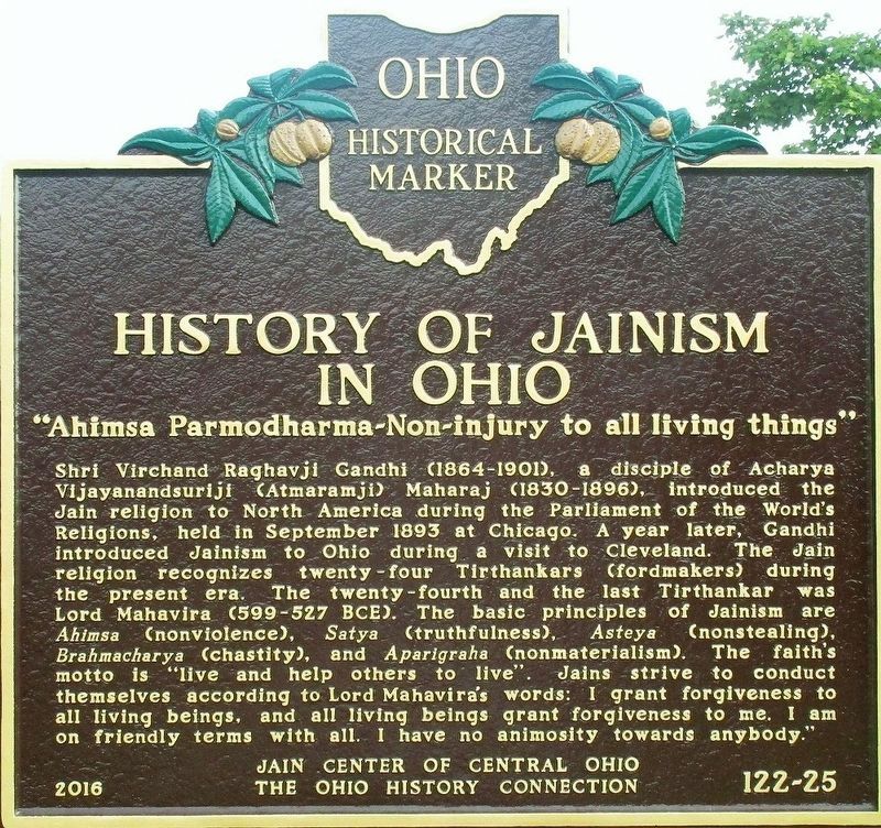
By Rev. Ronald Irick, July 14, 2017
History of Jainism in Ohio Marker
RANKED BY RELEVANCE
1 ► Ohio, Delaware County, Lewis Center — 122-25 — First Jain Temple in Central Ohio / History of Jainism in Ohio —  |
| On South Old State Road (County Route 10) at Ashcreek Avenue, on the right when traveling north on South Old State Road. | |||
| 2 ► Ohio, Butler County, Bethany — 19-9 — First Jain Temple in Ohio / History of Jainism in Ohio — |
| Near Cincinnati Dayton Road. | |||
| 3 ► Ohio, Franklin County, Columbus, Uptown District — 80-25 — Ohio in the Civil War / Defending Ohio — The Ohio National Guard and the 37th (Buckeye) Infantry Division — |
| On East State Street west of South 3rd Street, on the right when traveling west. | |||
| 4 ► Ohio, Tuscarawas County, New Philadelphia — 5-79 — The Ohio-Erie Canal In Tuscarawas County / The Ohio-Erie Canal 1825-1913 — |
| On Commercial Avenue SE (Ohio Route 416) at Canal Avenue SE, on the left when traveling south on Commercial Avenue SE. | |||
| 5 ► Ohio, Franklin County, Columbus, Fairgrounds — 72-25 — The Ohio State Fair — |
| Near East 17th Street west of Interstate 71. | |||
| 6 ► Ohio, Perry County, Somerset — 2-64 — A Seed of Catholic Education in Ohio / The Cradle of Catholicity in Ohio — |
| On South Columbus Street (Ohio Route 13) north of Summit Street, on the right when traveling south. | |||
| 7 ► Ohio, Franklin County, Columbus, Teakwood — 114- 25 — Ohio Dominican University Est. 1911 / Early Sister-Founderesses of Ohio Dominican University — |
| On Sunbury Road, on the left when traveling south. | |||
| 8 ► Ohio, Hardin County, Ada — 14-33 — Ohio Northern University — |
| On Main Street (Ohio Route 235) at College Avenue, on the right when traveling south on Main Street. | |||
| 9 ► Ohio, Franklin County, Columbus, South Columbus — 92-25 — Site of First Ohio State Home Football Game / The Ohio State University First Football Team — / 1890 |
| On East Whittier Street at Blackberry Alley, on the right when traveling west on East Whittier Street. Reported missing. | |||
| 10 ► Ohio, Montgomery County, Dayton, McPherson — State of Ohio Korean War Memorial — and All Veterans' Memorial Walkway — |
| On Riverside Drive at the north bank of the Great Miami River, on the right when traveling north on Riverside Drive. | |||
| 11 ► Ohio, Huron County, New Haven — 7-39 — Historic New Haven, Ohio / Residents of Early New Haven, Ohio — |
| On Prairie Street east of North Street ( Route 61), on the right when traveling east. | |||
| 12 ► Ohio, Lucas County, Toledo — A86 — Michigan - Ohio State Line — Ohio Revolutionary Memorial Trail — Hull-Winchester Marches |
| On North Detroit Avenue south of Benore Road, on the right when traveling north. Reported missing. | |||
| 13 ► Ohio, Wood County, Luckey — A126 — to Whittaker's Reserve / to Dudley's Massacre — Ohio Revolutionary Memorial Trail — Harrison's March |
| On Fremont Pike (U.S. 20) at Bradner Road (County Route 16), on the right when traveling east on Fremont Pike. Reported missing. | |||
| 14 ► Ohio, Wood County, Perrysburg — A125 — to Brady's Island / to Fort Miami — Ohio Revolutionary Memorial Trail — Harrison's March |
| On Fremont Pike (U.S. 20) east of Thompson Road, on the right when traveling east. Reported missing. | |||
| 15 ► Ohio, Wood County, Perrysburg — A123 — to Fort Meigs / to Fort Meigs — Ohio Revolutionary Memorial Trail — Harrison-Hull-Tupper Marches |
| On West Boundary Street (Ohio Route 25) near West Front Street ( Route 65), on the left when traveling north. Reported missing. | |||
| 16 ► Ohio, Wood County, Perrysburg — A124 — to Fort Stephenson / to Fort Meigs — Ohio's Revolutionary Memorial Trail — Harrison's March 1813 |
| On West Front Street (Ohio Route 65) at West Boundary Street ( Route 25), on the right when traveling west on West Front Street. Reported missing. | |||
| 17 ► Ohio, Wyandot County, Morral, Pitt Township — A147 — to Fort Morrow / to Fort Ferree — Ohio's Revolutionary Memorial Trail — Harrison's March 1813 |
| On County Route 113 south of County Route 126, on the right when traveling south. Reported permanently removed. | |||
| 18 ► West Virginia, Ohio County, Wheeling — Ohio County / State of Ohio |
| On Zane Street (U.S. 40) near Bridge Park, on the right when traveling west. Reported missing. | |||
| 19 ► Ohio, Lucas County, Maumee — A84 — to Hull's Crossing / to River Raisin — Ohio Revolutionary Memorial Trail — Hull-Winchester Marches |
| On River Road at South Detroit Avenue, on the right when traveling north on River Road. Reported missing. | |||
| 20 ► Ohio, Wood County, Perrysburg — A122 — to Dudley's Massacre / to Portage Stockade — Ohio Revolutionary Memorial Trail — Harrison-Hull-Tupper Marches |
| On Dixie Highway (Ohio Route 25) at Ovitt Road (County Route 104), on the left when traveling north on Dixie Highway. Reported missing. | |||
| 21 ► Ohio, Wyandot County, Lovell — A140 — to Crawford's Burning / to Battle Island — Ohio Revolutionary Memorial Trailh — Harrison's March |
| On Ohio Route 199 at County Route 42, on the left when traveling north on Ohio Route 199. Reported missing. | |||
| 22 ► Tennessee, Hardin County, Shiloh, Pittsburg Landing — 65th Ohio Infantry — Garfield's Brigade - Wood's Division — Army of the Ohio — |
| On Pittsburg Landing Road, on the right when traveling west. | |||
| 23 ► Tennessee, Hardin County, Shiloh, Pittsburg Landing — Battery A, 1st Ohio Light Artillery — McCook's Division — Army of the Ohio — |
| On Pittsburg Landing Road, on the right when traveling west. | |||
| 24 ► Pennsylvania, Adams County, Gettysburg, Cumberland Township — 29th Ohio Infantry — 1st Brigade, 2nd Division — 12th Corps — |
| On Slocum Avenue, on the right when traveling north. | |||
| 25 ► Tennessee, Hamilton County, Lookout Mountain — MT250-51 — Ohio — |
| Near Shingle Road 0.1 miles north of Military Road. | |||
| 26 ► Ohio, Wyandot County, Upper Sandusky — C481 — Fort Ferree — Ohio Revolutionary Memorial Trail |
| On S. Sandusky Avenue (Ohio Route 53) at E. Wyandot Avenue (U.S. 30), on the right when traveling north on S. Sandusky Avenue. Reported permanently removed. | |||
| 27 ► Tennessee, Hardin County, Shiloh, Pittsburg Landing — 5th Ohio Cavalry — 1st, 2nd, and 3rd Battalions — Army of the Tennessee — |
| On Pittsburg Landing Road, on the right when traveling west. | |||
| 28 ► Ohio, Hancock County, Findlay — 14-32 — The Ohio Oil Co - Marathon Oil Co / Gas Boom Era — |
| On Main Cross Street (Ohio Route 12) at Cory Street, on the right when traveling west on Main Cross Street. | |||
| 29 ► Tennessee, Hamilton County, Chattanooga, Missionary Ridge — MT-247 — Ohio Monument — |
| On South Crest Road south of Ridge Road, on the right when traveling south. | |||
| 30 ► Ohio, Athens County, Athens — 9-5 — Ohio University — Peden Stadium — |
| On South Green Drive 0.1 miles east of Richland Avenue (U.S. 50), on the right when traveling east. | |||
| 31 ► Georgia, Walker County, Fort Oglethorpe — MT-975 — 21st Ohio Infantry — Sirwell's Brigade — Negley's Division — |
| Near Vittetoe Road west of Vittetoe-Chickamauga Road when traveling west. | |||
| 32 ► Ohio, Franklin County, Columbus, University District — 38-25 — Old Ohio Union — |
| On 12th Avenue, on the right when traveling west. | |||
| 33 ► Ohio, Columbiana County, East Liverpool — 16-15 — Ohio's Gateway — |
| Near Walnut Street. | |||
| 34 ► Ohio, Pickaway County, Circleville — 5-65 — Camp Circleville — 90th Ohio Volunteer Infantry / 114th Ohio Volunteer Infantry — |
| On Tarlton Road at Kingston Pike, on the left when traveling east on Tarlton Road. | |||
| 35 ► Pennsylvania, Adams County, Gettysburg, Cumberland Township — 107th Ohio Infantry — Ohio's Token of Gratitude — |
| On Howard Avenue 0.5 miles east of Carlisle Road (Pennsylvania Highway 34), on the right when traveling east. | |||
| 36 ► Pennsylvania, Adams County, Gettysburg, Cumberland Township — 5th Ohio Infantry — 1st Brigade — 2nd Division 12th Corps — |
| On Geary Avenue at Slocum Avenue, on the left when traveling north on Geary Avenue. | |||
| 37 ► Ohio, Pike County, Waverly — 6-66 — Ohio and Erie Canal — |
| On Wendy Lane at 2nd Street ( Route 335), on the right when traveling south on Wendy Lane. | |||
| 38 ► Ohio, Meigs County, Portland — 25 — Buffington Island — War Reaches Ohio — John Hunt Morgan Heritage Trail — |
| Near Ohio River Scenic Byway (Ohio Route 124) south of New Portland Road, on the right when traveling south. | |||
| 39 ► Kentucky, Henderson County, Henderson — The Ohio River — |
| Near North Water Street south of 2nd Street, on the left when traveling north. | |||
| 40 ► Pennsylvania, Adams County, Gettysburg, Cumberland Township — 25th and 75th Ohio Infantry — 2nd Brigade 1st Division 11th Corps — |
| On Howard Avenue 0.2 miles north of Old Harrisburg Road (Business U.S. 15), on the right when traveling east. | |||
| 41 ► Ohio, Erie County, Sandusky — 15-22 — Ohio Veterans Home — (Ohio Soldiers' and Sailors' Home, 1888-1979) — |
| Near Milan Road (U.S. 20) east of Dewitt Avenue (County Route 92), on the right when traveling east. | |||
| 42 ► Ohio, Lucas County, Maumee — C27 — Dudley's Massacre — Ohio Revolutionary Memorial Trail — |
| On River Road 0.1 miles north of East John Street, on the right when traveling south. | |||
| 43 ► Ohio, Athens County, Athens — 4-5 — Ohio University — |
| On Union Street at Court Street, on the right when traveling east on Union Street. | |||
| 44 ► Ohio, Erie County, Sandusky — 19-22 — Ohio Veterans Home — (Ohio Soldiers' and Sailors' Home, 1888-1979) — |
| On Milan Road (U.S. 250) east of Dewitt Avenue (County Route 92), on the right when traveling east. | |||
| 45 ► Ohio, Washington County, Marietta — 11-84 — The Northwest Ordinance, 1787 / The Ohio Company Purchase — |
| On Second Street at St. Clair Street, on the right when traveling south on Second Street. | |||
| 46 ► Ohio, Champaign County, Mingo — 7-11 — Ohio Caverns — |
| Near Ohio 245. | |||
| 47 ► Ohio, Wayne County, Wooster — 3-85 — Ohio Agricultural Experiment Station — |
| On Williams Road at Gerlaugh Drive, on the left when traveling east on Williams Road. | |||
| 48 ► Ohio, Fulton County, Archbold — 3-26 — The Ohio Art Company — |
| On S. Defiance Street (Ohio Route 66) south of Stryker Street ( Route 2), on the left when traveling south. | |||
| 49 ► Tennessee, Hamilton County, Chattanooga, Missionary Ridge — MT-249 — Ohio at Chickamauga — September 18 - 21, 1863. — |
| On South Crest Road 0.1 miles south of Ridge Road, on the right when traveling south. | |||
| 50 ► Ohio, Stark County, Canal Fulton, Lawrence Township — 1-76 — Ohio and Erie Canal — |
| Near Congressman Ralph Regula Towpath Trail 1.3 miles east of Cherry Street West ( Route 93), on the right when traveling east. | |||
| 51 ► Ohio, Summit County, Akron, Downtown — 52-77 — Ohio Education Association — |
| On South High Street at Church Street, on the right when traveling north on South High Street. | |||
| 52 ► Pennsylvania, Adams County, Gettysburg, Cumberland Township — 1st Ohio Light Artillery, Battery H (Huntington's Battery) — 3rd Volunteer Brigade — Artillery Reserve — |
| Near Taneytown Road (State Highway 134), on the right when traveling north. | |||
| 53 ► Pennsylvania, Adams County, Gettysburg, Cumberland Township — 7th Ohio Infantry — 1st Brigade, 2nd Division — 12th Corps — |
| On Slocum Avenue at Williams Avenue, on the right when traveling north on Slocum Avenue. | |||
| 54 ► Ohio, Athens County, Athens — Ohio University Sundial — |
| On University Terrace 0.1 miles south of East Union Street, on the left when traveling north. | |||
| 55 ► Ohio, Licking County, Heath — Ohio Canal Was Started — |
| On Hebron Road (Ohio Route 79) 0.1 miles south of Coffman Boulevard, on the left when traveling south. | |||
| 56 ► Ohio, Franklin County, Columbus, Fairgrounds — Geological Cross Section of Ohio — |
| On East 11th Avenue at Essex Avenue, on the right when traveling north on East 11th Avenue. | |||
| 57 ► Ohio, Franklin County, Columbus, Fairgrounds — Ohio Shapes A Nation — The heart of it all was the start of it all — |
| On East 11th Avenue at Essex Avenue, on the right when traveling west on East 11th Avenue. | |||
| 58 ► Ohio, Fulton County, Seward, Royalton Township — 2-26 — The Ohio Michigan Boundary War / Battle of Phillips Corners — Ohio Historical Markers — |
| On Ohio Route 109 at Route 120, on the left when traveling north on Ohio Route 109. | |||
| 59 ► Indiana, Martin County, Shoals — Shoals Golden Spike — Baltimore and Ohio • Ohio and Mississippi — |
| On Main Street south of 4th Street (U.S. 50), on the left when traveling south. | |||
| 60 ► Ohio, Franklin County, Columbus, University District — 5-25 — The Ohio State University — |
| Near Neil Avenue. | |||
| 61 ► Ohio, Franklin County, Columbus, Woodland Park — 139-25 — Ohio Baptist General Association Headquarters — |
| On Parkwood Avenue at Maplewood Alley, on the right when traveling north on Parkwood Avenue. | |||
| 62 ► Ohio, Franklin County, Columbus, Olentangy West — 117- 25 — A. B. Graham and the 4-H Movement / Nationwide and Ohio Farm Bureau 4-H Center — |
| On Fred Taylor Drive at Borror Dr., on the left when traveling north on Fred Taylor Drive. | |||
| 63 ► Pennsylvania, Adams County, Gettysburg — 4th Ohio Infantry — 1st Brigade, 3rd Division — 2nd Corps — |
| On Baltimore Pike (State Highway 97), on the right when traveling north. | |||
| 64 ► Pennsylvania, Adams County, Gettysburg, Cumberland Township — 8th Ohio Infantry — Carroll's Brig. 3d Div. 2d Corps, July 2, 3, 1863. — Ohio's Tribute — |
| On Steinwehr Avenue (Business U.S. 15) at Long Lane, on the left when traveling north on Steinwehr Avenue. | |||
| 65 ► Pennsylvania, Adams County, Gettysburg, Cumberland Township — Companies G and I, 4th Ohio Infantry — 1st Brigade, 3d Division, 2d Corps — July 2, 1863 — |
| On Steinwehr Avenue (Business U.S. 15) at Hancock Avenue, on the right when traveling north on Steinwehr Avenue. | |||
| 66 ► Pennsylvania, Adams County, Gettysburg, Cumberland Township — Sixth Ohio Cavalry — 2nd Brigade, 2nd Division — Cavalry Corps — |
| On Taneytown Road (Route 134) at Pleasonton Avenue, on the right when traveling south on Taneytown Road. | |||
| 67 ► Tennessee, Hamilton County, Chattanooga, Missionary Ridge — MT-254 — 3d Ohio Cavalry — Long's Brigade - Crook's Division — Stanley's Corps — |
| On South Crest Road 0.1 miles Ridge Road, on the right when traveling south. | |||
| 68 ► Georgia, Catoosa County, Fort Oglethorpe — MT-1023 — 93rd Ohio Infantry — Baldwin's Brigade — |
| On Battleline Road south of Alexander Bridge Road, on the right when traveling south. | |||
| 69 ► Ohio, Hamilton County, Cincinnati, Over-The-Rhine — C62 — Ohio Military Trails — Ohio Revolutionary Memorial Trail — |
| On East Central Parkway (U.S. 42) near Main Street, in the median. | |||
| 70 ► Ohio, Delaware County, Delaware — C — Pluggy's Town — Ohio Revolutionary Memorial Trail |
| On North Sandusky Street at East Lincoln Avenue, on the right when traveling north on North Sandusky Street. Reported permanently removed. | |||
| 71 ► Ohio, Lucas County, Toledo, Glendale-Heatherdowns — 24-48 — Medical College of Ohio — Ohio Historical Marker — |
| On MUOT Boulevard north of Glendale Avenue, on the right when traveling north. | |||
| 72 ► Tennessee, Hardin County, Shiloh, Pittsburg Landing — 64th Ohio Infantry — Garfield's Brigade - Wood's Division — Army of the Ohio — |
| On Pittsburg Landing Road, on the right when traveling west. | |||
| 73 ► Ohio, Franklin County, Columbus, West Campus — 71-25 — Ohio Agricultural Experiment Station — |
| On Carmack Road 0.2 miles north of West Lane Avenue, on the right when traveling north. | |||
| 74 ► Ohio, Muskingum County, Zanesville — 7-60 — Second Capital of Ohio — |
| On Main Street (U.S. 40) east of 4th Street, on the left when traveling east. | |||
| 75 ► Pennsylvania, Adams County, Gettysburg, Cumberland Township — 82nd Ohio Volunteer Infantry Regiment — |
| On Howard Avenue 0.1 miles east of Carlisle Road (Pennsylvania Highway 34), on the right when traveling east. | |||
| 76 ► West Virginia, Jefferson County, Harpers Ferry — The Race to the Ohio — |
| Near South Potomac Street. | |||
| 77 ► Ohio, Defiance County, Defiance — A95 — Fort Defiance — Ohio Revolutionary Memorial Trail — Wayne-Harrison-Winchester-Clay-Bird Marches — |
| On Fort Street at South Clinton Street ( Route 66), on the right when traveling west on Fort Street. | |||
| 78 ► Ohio, Defiance County, Defiance — A96 — Fort Winchester — Ohio Revolutionary Memorial Trail — Wayne-Harrison-Winchester-Clay-Bird Marches — |
| On Fort Street at Washington Avenue, on the right when traveling west on Fort Street. | |||
| 79 ► Pennsylvania, Adams County, Gettysburg, Cumberland Township — 25th and 75th Ohio Infantry Regiments — 2nd Brigade, 1st Division — 11th Corps — |
| On Wainwright Avenue, on the left when traveling north. | |||
| 80 ► Ohio, Adams County, Manchester — 11-1 — Manchester, Ohio — First Settlement, Virginia Military District — |
| On West Front Street at Pearl Street, on the right when traveling west on West Front Street. | |||
| 81 ► Ohio, Cuyahoga County, Cleveland, Downtown — 79-18 — The Ohio AFL-CIO — |
| On Lakeside Avenue at East 6th Street on Lakeside Avenue. | |||
| 82 ► Ohio, Seneca County, Fort Seneca — A1340 — to Brady's Island / to Battle Island — Ohio Revolutionary Memorial Trail — Harrison-Shelby Marches — |
| On Fremont-Tiffin Road (Ohio Route 53) at Township Road 1020 on Fremont-Tiffin Road. | |||
| 83 ► Ohio, Shelby County, Fort Loramie — C — Pioneer Portage — Ohio Revolutionary Memorial Trail |
| On North Main Street (Ohio Route 66) at Elm Street ( Route 362), on the right when traveling south on North Main Street. Reported missing. | |||
| 84 ► Ohio, Stark County, Alliance — 20-76 — Alliance-Birthplace of Ohio's State Flower - The Scarlet Carnation — |
| On West Main Street 0.1 miles west of South Union Avenue ( Route 183), on the right when traveling west. | |||
| 85 ► Pennsylvania, Adams County, Gettysburg — 73rd Ohio Infantry — 2d Brigade, 2d Division — 11th Corps — |
| On Taneytown Road / Washington Street (State Highway 134), on the right when traveling north. | |||
| 86 ► Ohio, Brown County, Russellville — B — Logan's Crossing 1796 Directional Marker — Ohio Revolutionary Memorial Trail — |
| On Columbus Street (U.S. 62) near Main Street ( Route 125), on the right when traveling south. | |||
| 87 ► Ohio, Clark County, Springfield — C — Kenton's Stockade — Ohio Revolutionary Memorial Trail — |
| On Main Street (U.S. 40) west of Broadway Street, on the right when traveling west. | |||
| 88 ► Ohio, Fairfield County, Lockville — Ohio's Canal System |
| Near Pickerington Road Northwest (County Road 20) south of Broad Street Northwest, on the right when traveling south. Reported permanently removed. | |||
| 89 ► Ohio, Logan County, West Liberty — C — Mac-O-Chee Towns — Ohio Revolutionary Memorial Trail |
| On Route 245 at Township Road 47, on the right when traveling east on Route 245. Reported missing. | |||
| 90 ► Ohio, Ross County, Metzger — 15-71 — The Great Seal of the State of Ohio — |
| Near Main Road. | |||
| 91 ► Tennessee, Hamilton County, Chattanooga, Missionary Ridge — MT-268 — 14th Ohio Infantry — Phelp's Brig., Baird's Div., 14 Corps. — Lieut. Col. Henry D. Kingsbury. — |
| On North Crest Road north of Crest Terrace Drive, on the left when traveling north. | |||
| 92 ► Ohio, Carroll County, Malvern — 2-10 — The Great Trail / The Ohio Country in the Revolution — |
| Near West Canal Street (Ohio Route 183), on the right when traveling east. | |||
| 93 ► Tennessee, Hamilton County, Chattanooga, Missionary Ridge — MT-248 — Ohio at Chattanooga — November 23-25, 1863 — |
| On South Crest Road 0.1 miles Ridge Road, on the right when traveling south. | |||
| 94 ► Tennessee, Hardin County, Shiloh — 1st Ohio Infantry — Rousseau's Brigade - McCook's Division — Army of the Ohio — |
| On Corinth-Pittsburg Landing Road, on the right when traveling west. | |||
| 95 ► Indiana, Spencer County, Troy — Ohio River Scenic Byway — |
| On Indiana Route 66 just east of County Road 1290E, on the right when traveling east. | |||
| 96 ► Ohio, Belmont County, St. Clairsville — 20-7 — Belmont County / Groundbreaking Site of the National Road in Ohio — |
| On West Main Street (U.S. 40) at South Market Street, on the left when traveling east on West Main Street. | |||
| 97 ► Ohio, Defiance County, Defiance — C32 — Fort Winchester — Ohio Revolutionary Memorial Trail — |
| On West 2nd Street at Washington Avenue, on the right when traveling east on West 2nd Street. | |||
| 98 ► Ohio, Hamilton County, Cincinnati, Central Business District — 12-31 — 1749 French Claims to Ohio River Valley — |
| Near Purple People Bridge. | |||
| 99 ► Ohio, Miami County, Piqua — C — Fort Pickawillany — Ohio Revolutionary Memorial Trail |
| On North Hardin Road (County Route 110) north of Ohio Route 66, on the right when traveling north. Reported missing. | |||
| 100 ► Ohio, Muskingum County, Norwich — The Historic National Road in Ohio — Mile Markers — |
| Near East Pike National Road (U.S. 40) at Zane Grey Road (County Route 199). | |||
12363 entries matched your criteria. The first 100 are listed above. Next 100 ⊳
Thin black lines indicate changes in relevance. Between each pair of lines entries are ordered geographically but all have the same relevance.
* Inflectional forms of words are their plurals, singulars, and possessives as well as gramatical tenses and similar variations.
Nov. 11, 2026