141 entries match your criteria. The first 100 are listed. ⊳
Historical Markers and War Memorials
in South County Region
By Cosmos Mariner
Memorial detail: Names & Dates
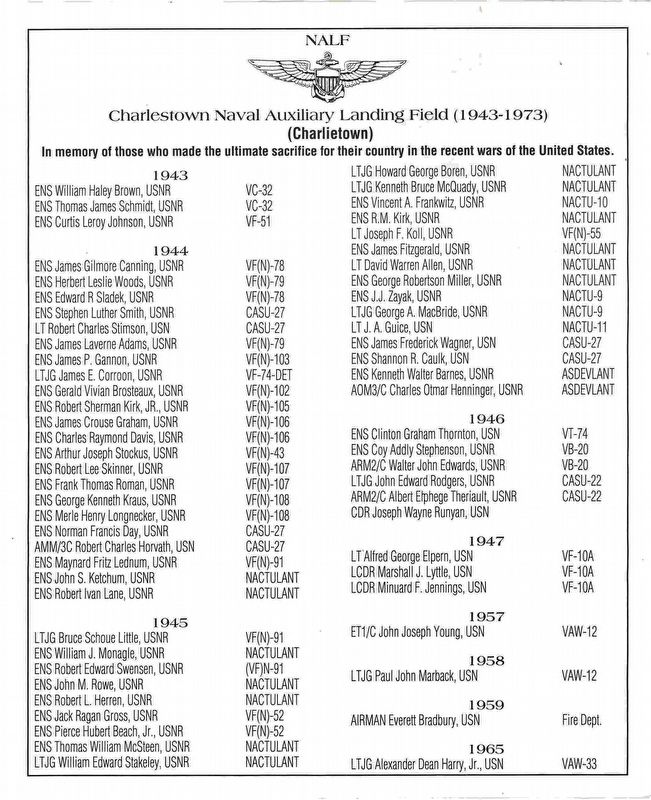
1 ► Rhode Island, Washington County, Charlestown — Charlestown Naval Auxiliary Landing Field Memorial — -1943- “Charlietown” -1973- —  |
| On Park Lane south of Old Post Road (Rhode Island Route 1A), on the left when traveling south. | |||
| 2 ► Rhode Island, Washington County, Charlestown — Cross' Mills — Welcomes You — Est. 1709 | Charlestown, RI. — |
| On Old Post Road (Rhode Island Route 1A) at Cross Mills Road when traveling west on Old Post Road. | |||
| 3 ► Rhode Island, Washington County, Charlestown — Cross' Mills Common Burying Ground — |
| On East Arnolda Drive at Old Post Road ( Route 1A), on the right when traveling south on East Arnolda Drive. | |||
| 4 ► Rhode Island, Washington County, Charlestown — Fort Ninigret — |
| On Old Post Road (U.S. 1A) at Fort Ninigret Road, on the right when traveling east on Old Post Road. | |||
| 5 ► Rhode Island, Washington County, Charlestown — Fort Ninigret — |
| On Fort Ninigret Road 0.2 miles south of Old Post Road (State Route 1A), on the right when traveling south. | |||
| 6 ► Rhode Island, Washington County, Charlestown — Grumman F6F-5N Hellcat Crash — |
| On Park Lane south of Old Post Road ( Route 1A), on the left when traveling south. | |||
| 7 ► Rhode Island, Washington County, Charlestown — Liberty Tree Memorial — |
| On Park Lane south of Old Post Road ( Route 1A), on the right when traveling south. | |||
| 8 ► Rhode Island, Washington County, Charlestown — Ninigret National Wildlife Refuge — |
| On Ninigret Entrance Road 0.2 miles east of Post Road (U.S. 1), on the right when traveling east. | |||
| 9 ► Rhode Island, Washington County, Charlestown — Ninigret Park History — Welcome to Ninigret Park — |
| Near Park Lane 0.5 miles east of Old Post Road ( Road 1A), on the right when traveling east. | |||
| 10 ► Rhode Island, Washington County, Charlestown, Quonochontaug — General Joseph Stanton Monument — |
| On Old Post Road near Post Road (U.S. 1), on the left when traveling west. | |||
| 11 ► Rhode Island, Washington County, Exeter — Town of Exeter — Incorporated 1742 — |
| On Ten Rod Road (Rhode Island Route 102) east of Widow Sweets Road, on the left when traveling east. | |||
| 12 ► Rhode Island, Washington County, Exeter — World War II Memorial — 🦅 — Valor — |
| On Ten Rod Road (Rhode Island Route 102) east of Widow Sweets Road, on the right when traveling west. | |||
| 13 ► Rhode Island, Washington County, Exeter, Escoheag — 43d Infantry Division Memorial — |
| On South County Trail. | |||
| 14 ► Rhode Island, Washington County, Exeter, Escoheag — Address by President Abraham Lincoln — November 19, 1863 — |
| Near South County Trail (Rhode Island Route 2) 0.2 miles south of Main Street (Exeter Road), on the right when traveling south. | |||
| 15 ► Rhode Island, Washington County, Exeter, Escoheag — Armed Services Memorial — |
| On South County Trail (Cemetery Entrance). | |||
| 16 ► Rhode Island, Washington County, Exeter, Escoheag — Dedicated to All Patriots — |
| Near South County Trail (Rhode Island Route 2) 0.2 miles south of Main Street (Exeter Road), on the right when traveling south. | |||
| 17 ► Rhode Island, Washington County, Exeter, Escoheag — In Memory of All War Veterans — Patriots Memorial Grove — |
| Near South County Trail (Rhode Island Route 2) 0.2 miles south of Main Street (Exeter Road), on the right when traveling south. | |||
| 18 ► Rhode Island, Washington County, Exeter, Escoheag — Jewish War Veterans — |
| On Veterans Place. | |||
| 19 ► Rhode Island, Washington County, Exeter, Escoheag — Lonely Lookout Memorial — |
| On South County Trail (Cemetery Entrance). | |||
| 20 ► Rhode Island, Washington County, Exeter, Escoheag — Medal of Honor-Honor Roll — |
| On South County Trail. | |||
| 21 ► Rhode Island, Washington County, Exeter, Escoheag — Rhode Island National Guard — |
| On South County Trail. | |||
| 22 ► Rhode Island, Washington County, Exeter, Escoheag — U.S. Navy Armed Guard Memorial — |
| On South County Trail. | |||
| 23 ► Rhode Island, Washington County, Exeter, Escoheag — We Aim-To Deliver — |
| On South County Trail. | |||
| 24 ► Rhode Island, Washington County, Hopkinton — Governor Stephen Hopkins — |
| On Townhouse Road south of Main Street ( Route 3) when traveling south. | |||
| 25 ► Rhode Island, Washington County, Hopkinton — Town of Hopkinton Founders Monument — |
| On Townhouse Road south of Main Street ( Route 3), on the left when traveling south. | |||
| 26 ► Rhode Island, Washington County, Hopkinton, Ashaway — 7th Day Baptist Churches of Hopkinton and Westerly — |
| On Nooseneck Hill Road (U.S. 3) at Chase Hill Road, on the right when traveling south on Nooseneck Hill Road. | |||
| 27 ► Rhode Island, Washington County, Hopkinton, Ashaway — First Seventh Day Baptist Church of Hopkinton — 1622-1935 — |
| On Church Street at Main St. (U.S. 3), on the right when traveling west on Church Street. | |||
| 28 ► Rhode Island, Washington County, Hopkinton, Ashaway — Seventh Day Baptist Minister's Monument — 1680 - 1899 — |
| On Chase Hill Road at Rt 3 and Chase Hill Road (U.S. 3), on the left when traveling east on Chase Hill Road. | |||
| 29 ► Rhode Island, Washington County, Hopkinton, Ashaway — World War I Memorial — |
| On Main Street (Rhode Island Route 3) at Townhouse Road, on the right when traveling south on Main Street. | |||
| 30 ► Rhode Island, Washington County, Hopkinton, Hope Valley — Depot Square Park — |
| On Mechanic Street at Nooseneck Hill Road ( Route 3), on the right when traveling north on Mechanic Street. | |||
| 31 ► Rhode Island, Washington County, Hopkinton, Hope Valley — Old Stone Dam — Circa 1765 — |
| On Mechanic Street at Maple Avenue, on the left when traveling south on Mechanic Street. | |||
| 32 ► Rhode Island, Washington County, Hopkinton, Hope Valley — Polish-American Citizens Club World War II Memorial — 1941 - 1945 — 🦅 — |
| On Mechanic Street at Highview Avenue, on the left when traveling north on Mechanic Street. | |||
| 33 ► Rhode Island, Washington County, Hopkinton, Hope Valley — Welcome to Brushy Brook — Mechanic Street Access — Located at 8 Mechanic Street — |
| On Mechanic Street south of Main Street ( Route 3), on the left when traveling south. | |||
| 34 ► Rhode Island, Washington County, Narragansett, Point Judith — "Chief Canonchet" — |
| On Ocean Road (Rhode Island Route 1A) at Beach Street, on the left when traveling north on Ocean Road. | |||
| 35 ► Rhode Island, Washington County, Narragansett, Point Judith — “Prisoners of Conscience“ — A Living Memorial — Amnesty International — |
| On Beach Street at Ocean Road, on the right when traveling north on Beach Street. | |||
| 36 ► Rhode Island, Washington County, Narragansett, Point Judith — A Model of Innovation — 1948 - 76 — |
| On Great Island Road just north of State Street, on the left when traveling north. | |||
| 37 ► Rhode Island, Washington County, Narragansett, Point Judith — From Fishing Village to Fishing Port — Up to 1948 — |
| On Great Island Road at Galilee Connector Road, on the right when traveling north on Great Island Road. | |||
| 38 ► Rhode Island, Washington County, Narragansett, Point Judith — From Trap to Table — |
| On Great Island Road north of State Street, on the left when traveling north. | |||
| 39 ► Rhode Island, Washington County, Narragansett, Point Judith — From Trawl to Table — |
| On Ferry Terminal just west of Great Island Road, on the left when traveling west. | |||
| 40 ► Rhode Island, Washington County, Narragansett, Point Judith — Galilee: A Working Waterfront — |
| On Great Island Road just north of Ferry Terminal, on the right when traveling south. | |||
| 41 ► Rhode Island, Washington County, Narragansett, Point Judith — Growth and Its Limits — 1976 - 90 — |
| On Great Island Road just north of Galilee Connector Road, on the left when traveling north. | |||
| 42 ► Rhode Island, Washington County, Narragansett, Point Judith — Honor Roll Town of Narragansett World War — |
| On Kingstown Road at Strathmore Street on Kingstown Road. | |||
| 43 ► Rhode Island, Washington County, Narragansett, Point Judith — In It for the Long Haul — 1990 - Modern Day — |
| On Great Island Road north of State Street, on the left when traveling north. | |||
| 44 ► Rhode Island, Washington County, Narragansett, Point Judith — Point Judith Light House — |
| On Ocean Road (Rhode Island Route 108). | |||
| 45 ► Rhode Island, Washington County, Narragansett, Point Judith — The Narragansett Pier — Towers & Casino — Architects: McKim, Mead & White — |
| On Ocean Road. | |||
| 46 ► Rhode Island, Washington County, Narragansett, Point Judith — The S.S. Black Point — |
| On Ocean Road. | |||
| 47 ► Rhode Island, Washington County, New Shoreham, Block Island — A strong community-based conservation ethic. — |
| On Ocean Avenue just south of West Side Road, on the left when traveling south. | |||
| 48 ► Rhode Island, Washington County, New Shoreham, Block Island — Block Island Historical Society — 1942 — |
| On Old Town Road at Ocean Avenue, on the left when traveling north on Old Town Road. | |||
| 49 ► Rhode Island, Washington County, New Shoreham, Block Island — Double Ender — |
| On Old Town Road just south of Ocean Avenue, on the right when traveling south. | |||
| 50 ► Rhode Island, Washington County, New Shoreham, Block Island — Fort Island — 🥁 Indian Fort — 1661 |
| On Ocean Avenue 0.1 miles south of West Side Road, on the right when traveling south. Reported damaged. | |||
| 51 ► Rhode Island, Washington County, New Shoreham, Block Island — Fresh Pond — Elevation 78 Ft. — 1661 — |
| On Lakeside Drive at Old Center Road on Lakeside Drive. | |||
| 52 ► Rhode Island, Washington County, New Shoreham, Block Island — Harbor Bay and Harbor Pond — 1707 — Block Island Historical Society — |
| On Corn Neck Road 0.2 miles north of Ocean Avenue, on the left when traveling north. | |||
| 53 ► Rhode Island, Washington County, New Shoreham, Block Island — Korean War Memorial — |
| On West Side Road at Legion Way, on the left when traveling west on West Side Road. | |||
| 54 ► Rhode Island, Washington County, New Shoreham, Block Island — Life Saving Cart — |
| On Old Town Road just south of Ocean Avenue, on the right when traveling south. | |||
| 55 ► Rhode Island, Washington County, New Shoreham, Block Island — Mohegan Bluffs — Elevation 163 Ft. — |
| Near Spring Street. | |||
| 56 ► Rhode Island, Washington County, New Shoreham, Block Island — New Shoreham — |
| On Water Street at Dodge Street, on the right when traveling north on Water Street. | |||
| 57 ► Rhode Island, Washington County, New Shoreham, Block Island — Nicholas Ball Park — |
| On Adrian House Lane south of Water Street, on the right when traveling south. | |||
| 58 ► Rhode Island, Washington County, New Shoreham, Block Island — Old Mill and Garrison Stone House — Block Island Historical Society — 1942 — |
| On Old Town Road 0.1 miles west of Mill Pond Lane, on the right when traveling west. | |||
| 59 ► Rhode Island, Washington County, New Shoreham, Block Island — To your left is the Great Salt Pond, the jewel of Block Island. — |
| On Ocean Avenue just south of West Side Road, on the left when traveling south. | |||
| 60 ► Rhode Island, Washington County, New Shoreham, Block Island — Transfer of Block Island — |
| On Old Town Road 0.1 miles west of Mill Pond Lane, on the left when traveling west. | |||
| 61 ► Rhode Island, Washington County, New Shoreham, Block Island — Trustrum Dodge — Block Island Historical Society — 1942 — |
| On Corn Neck Road 0.3 miles north of Dodge Street, on the right when traveling north. | |||
| 62 ► Rhode Island, Washington County, New Shoreham, Block Island — U.S.S. Block Island — |
| On West Side Road at Legion Way, on the left when traveling west on West Side Road. | |||
| 63 ► Rhode Island, Washington County, New Shoreham, Block Island — Vietnam War Memorial — |
| On West Side Road at Legion Way, on the left when traveling west on West Side Road. | |||
| 64 ► Rhode Island, Washington County, New Shoreham, Block Island — World War I Memorial — 🦅 — |
| On Dodge Street at Old Town Road, on the right when traveling east on Dodge Street. | |||
| 65 ► Rhode Island, Washington County, New Shoreham, Block Island — World War II Memorial — |
| On West Side Road at Legion Way, on the left when traveling west on West Side Road. | |||
| 66 ► Rhode Island, Washington County, North Kingstown — Captain John Gallup — |
| Near Richard Smith Drive east of Post Road (U.S. 1), on the right when traveling east. | |||
| 67 ► Rhode Island, Washington County, North Kingstown — Cocumscussoc Archaeological Site — (Smith’s Castle) — |
| Near Richard Smith Drive east of Post Road (U.S. 1), on the right when traveling east. | |||
| 68 ► Rhode Island, Washington County, North Kingstown — Here Were Bvried — |
| Near Richard Smith Drive east of Post Road (U.S. 1), on the right when traveling east. | |||
| 69 ► Rhode Island, Washington County, North Kingstown — Rabbit Island — 🐄 — |
| Near Richard Smith Drive. | |||
| 70 ► Rhode Island, Washington County, North Kingstown — Roger Williams — |
| On Post Road (U.S. 1) south of Old Post Road, on the right when traveling north. | |||
| 71 ► Rhode Island, Washington County, North Kingstown — The Fighting Bee — A Rhode Island Creation — |
| On Iafrate Way north of Gate Road, on the right when traveling north. | |||
| 72 ► Rhode Island, Washington County, North Kingstown, Lafayette — A Millworker's Life — Lafayette — A Southern Rhode Island Mill Village — |
| Near Ten Rod Road (Rhode Island Route 102) just east of Advent Street, on the right when traveling east. | |||
| 73 ► Rhode Island, Washington County, North Kingstown, Lafayette — Centerpiece of the Rodman Empire — Lafayette — A Southern Rhode Island Mill Village — |
| On Ten Rod Road (Rhode Island Route 102) east of Advent Street, on the right when traveling east. | |||
| 74 ► Rhode Island, Washington County, North Kingstown, Lafayette — Hortense Rodman Allen House — 781 Ten Rod Road — Lafayette Village Historic District — |
| On Ten Rod Road (Rhode Island Route 102) east of Rodman Lane, on the right when traveling west. | |||
| 75 ► Rhode Island, Washington County, North Kingstown, Lafayette — Robert Rodman's Village — Lafayette — A Southern Rhode Island Mill Village — |
| On Ten Rod Road (Rhode Island Route 108) east of Advent Street, on the right when traveling east. | |||
| 76 ► Rhode Island, Washington County, North Kingstown, Lafayette — The New Mill & New Beginnings — Lafayette — A Southern Rhode Island Mill Village — |
| On Ten Rod Road (Rhode Island Route 102) east of Advent Street, on the right when traveling east. | |||
| 77 ► Rhode Island, Washington County, North Kingstown, Lafayette — The Rail Connection — Lafayette — A Southern Rhode Island Mill Village — |
| On Ten Rod Road (Rhode Island Route 102) east of Advent Street, on the right when traveling east. | |||
| 78 ► Rhode Island, Washington County, North Kingstown, Lafayette — The Shewatuck & The Beginnings of Industry — Lafayette — A Southern Rhode Island Mill Village — |
| On Ten Rod Road (Rhode Island Route 102) at Advent Street, on the right when traveling east on Ten Rod Road. | |||
| 79 ► Rhode Island, Washington County, North Kingstown, Saunderstown — Gilbert Stuart — Born here 1755 - Died in Boston 1828 — |
| On Gilbert Stuart Road west of Snuff Mill Road, on the right when traveling west. | |||
| 80 ► Rhode Island, Washington County, North Kingstown, Saunderstown — Gilbert Stuart Birthplace — |
| Near Gilbert Stuart Road. | |||
| 81 ► Rhode Island, Washington County, North Kingstown, Saunderstown — Gilbert Stuart Birthplace — |
| On Gilbert Stuart Road west of Snuff Mill Road, on the right when traveling west. | |||
| 82 ► Rhode Island, Washington County, North Kingstown, Saunderstown — Gilbert Stuart Snuff Mill — |
| On Boston Neck Road at Snuff Mill Road, on the right when traveling south on Boston Neck Road. | |||
| 83 ► Rhode Island, Washington County, North Kingstown, Wickford — North Kingstown G.A.R. Monument — |
| On Boston Neck Road (Rhode Island Route 1A) just north of Reynolds Street, on the right when traveling north. | |||
| 84 ► Rhode Island, Washington County, Richmond — A Maturing Town — Richmond Heritage Trail — |
| On Richmond Heritage Trail north of Country Acres Road, on the right when traveling south. | |||
| 85 ► Rhode Island, Washington County, Richmond — Early European Settlement — Richmond Heritage Trail — |
| On Richmond Heritage Trail north of Country Acres Road, on the right when traveling west. | |||
| 86 ► Rhode Island, Washington County, Richmond — Early Town of Richmond — Richmond Heritage Trail — |
| On Richmond Heritage Trail north of Country Acres Road, on the right when traveling south. | |||
| 87 ► Rhode Island, Washington County, Richmond — Post-Glaciation and Native Peoples — Richmond Heritage Trail — |
| On Richmond Heritage Trail north of Country Acres Road, on the right when traveling north. | |||
| 88 ► Rhode Island, Washington County, Richmond — Recent Times and the Future of Richmond — Richmond Heritage Trail — |
| On Richmond Heritage Trail north of Country Acres Road, on the right when traveling south. | |||
| 89 ► Rhode Island, Washington County, Richmond — Richmond: A Town with Vision of Its Heritage and History — Richmond Heritage Trail — |
| On Richmond Heritage Trail north of Country Acres Road, on the right when traveling north. | |||
| 90 ► Rhode Island, Washington County, Richmond — Vietnam and Desert Storm Memorial — |
| On Richmond Townhouse Road (Route 112) at Kingstown Road ( Route 138), on the left when traveling north on Richmond Townhouse Road. | |||
| 91 ► Rhode Island, Washington County, Richmond — World War I, World War II and the Korean Campaign Memorial — 1917 - 1955 — 🦅 — |
| On Richmond Townhouse Road at Route 112, on the right when traveling west on Richmond Townhouse Road. | |||
| 92 ► Rhode Island, Washington County, South Kingstown — Building a Legacy — The National Wildlife Refuge System — Celebrating a Century of Conservation — |
| Near Matunuck School House Road 0.3 miles east of Walden Way when traveling east. | |||
| 93 ► Rhode Island, Washington County, South Kingstown — Habitat Restoration at Trustom Pond National Wildlife Refuge — |
| On Farmer Trail Loop south of Matunuck School House Road, on the right when traveling south. | |||
| 94 ► Rhode Island, Washington County, South Kingstown — Pettaquamscutt Rock — |
| On Middlebridge Road at John Street, on the right when traveling south on Middlebridge Road. | |||
| 95 ► Rhode Island, Washington County, South Kingstown — Samuel E. Perry Grist Mill — South Kingstown Land Trust — |
| On Moonstone Beach Road 0.2 miles south of Commodore Perry Highway (U.S. 1), on the right when traveling north. | |||
| 96 ► Rhode Island, Washington County, South Kingstown — Trustom Pond National Wildlife Refuge — |
| On Farmer Loop Trail south of Matunuck School House Road, on the right when traveling south. | |||
| 97 ► Rhode Island, Washington County, South Kingstown, Kingston — "Little Rest" — |
| On Kingstown Road (Rhode Island Route 138) at Upper College Road, on the right when traveling west on Kingstown Road. | |||
| 98 ► Rhode Island, Washington County, South Kingstown, Kingston — Kings County Court House — 1776 - 1907 — |
| On Kingstown Road (Rhode Island Route 138) at Upper College Road, on the right when traveling west on Kingstown Road. | |||
| 99 ► Rhode Island, Washington County, South Kingstown, Kingston — Washington County Jail — 2636 Kingstown Road — |
| On Kingstown Road. | |||
| 100 ► Rhode Island, Washington County, South Kingstown, Wakefield — Griffin's Hollow — |
| On Main Street (Rhode Island Route 1A) south of Robinson Street, on the left when traveling south. | |||
141 entries matched your criteria. The first 100 are listed above. The final 41 ⊳